
Watling Street
Encyclopedia
Watling Street is the name given to an ancient trackway
in England and Wales
that was first used by the Britons
mainly between the modern cities of Canterbury
and St Albans
. The Romans later paved the route, part of which is identified on the Antonine Itinerary
as Iter III: "Item a Londinio ad portum Dubris" - from London to the port of Dover
. Its route is now covered by the A2 road
from Dover to London, and the A5 road from London to Wroxeter
.
The name derives from the Old English Wæcelinga Stræt. Originally the word "street" simply meant a paved road
(Latin: "via strata"), and did not have the modern association with populated areas.
in the south-east by way of a ford of the Thames at present-day Westminster
to near Wroxeter
, where one section went on to Holyhead
and another, by way of Chester
, on towards Scotland.
recorded in the Antonine Itinerary
as "Iter III" linked London and Dover. The last section of the long Iter II route from Hadrian's Wall
travelled through Viroconium (now Wroxeter in Shropshire
), past Letocetum
(modern day Wall
) in Staffordshire, Manduessedum
(modern day Mancetter
- possible site of Boudica
's last battle
), Venonis (modern day High Cross
) in Leicestershire, Bannaventa
near Norton in modern-day Northamptonshire, Lactodurum
(modern day Towcester
- near another possible site of Boudica's last battle), then through Stony Stratford
and Magiovinium (Fenny Stratford
) in modern-day Milton Keynes
, Durocobrivis (modern day Dunstable
) in Bedfordshire (where it crosses the even older Icknield Way
), Verulamium
(near modern-day St Albans
in Hertfordshire
) and London (by way of the ford at Thorney Island
until London Bridge
was finished, and the line of the modern Old Kent Road
) to Rutupiae
(now Richborough
in Kent
) on the southeast coast of England. While another section of Iter II linked Wroxeter to Chester, and other roads were built into north Wales
and central Wales, these are not generally considered to be part of Watling Street. Thus the Roman routes which comprise Watling Street are all of Iter III and the middle-southern section of Iter II.
Wæcelinga Stræt by the Anglo-Saxons, meaning "the paved road pertaining to the people of Wæcel". Wæcel could, possibly, be a variation of the Old English word for 'foreigner' which was applied to the Celt
ic people inhabiting what is now Wales. This place-name element also gave us the name for Wæclingacaester (the early English name for Verulamium) and it seems likely that the road-name was originally applied first to the section between that town and London before being applied to the entire road.
A number of ancient names that contain the Old English element stræt testify to the ancient route of Watling Street: Boughton Street
, Kent; Colney Street
, Hertfordshire; Fenny Stratford
, Stony Stratford
and Old Stratford
, all in Buckinghamshire; Stretton under Fosse and Stretton Baskerville
, both in Warwickshire; the three adjacent settlements of All Stretton
, Church Stretton
and Little Stretton
in Shropshire; and Stretton Sugwas
, Herefordshire.
 Stone Street ran southeast for some 12 miles from Watling Street at Canterbury
(the Roman Durovernum) to Lympne
(Lemanis) at the western edge of the Romney Marsh
. Most of it is now the current B2068 road that runs from the M20 motorway
to Canterbury
.
Another Stone Street from Magnis
(Kenchester) in modern Herefordshire
to Caerleon
, Isca Augusta
and the main Roman legion
ary base in the south of Roman Wales.
in 61 AD between the Roman governor Gaius Suetonius Paulinus
and the Briton leader Boudica
.
required the defeated Danes to withdraw to an area north and east of Watling Street, thus establishing the Danelaw
.
to Canterbury
in his Canterbury Tales.
firstly in 1707 when the section from Fourne hill north of Hockliffe
to Stony Stratford
was paved following an Act of Parliament on March 4, 1707.
This was the first Turnpike Trust and showed how financially hazardous the undertaking could be.
The road was re-paved in the early 19th century by Thomas Telford
who brought it back into use as a turnpike road for use by mail coaches bringing mail to and from Ireland
, his road being extended to the port of Holyhead
on the Isle of Anglesey in Wales
. At this time the section south of London became known as the Great Dover Road. The toll system ended in 1875.
Most of the road is still in use today, apart from a few sections where it has been diverted. The stretch of the road between London and Dover is today known as the A2
, and the stretch between London and Shrewsbury
is today known as the A5 (which now continues to Holyhead
). The sections of the road which pass through Central London are known by a variety of names, including Edgware Road and Maida Vale
. At Blackheath
the Roman road ran along Old Dover Road, then turning and running through Greenwich Park to head to a location perhaps a little north of the existing Deptford Bridge. Through Milton Keynes
, the A5 is diverted onto a new dual-carriageway and Watling Street forms part of the new town's grid system and carries the additional designation V4.
in Southeast London and on into Kent
(including the towns of Canterbury
, Gillingham, Rochester, Gravesend
and Dartford
). Also, in London, a major road joining the A5 in north west London is called Watling Avenue. North of London, the name Watling Street still occurs in Hertfordshire
(including St Albans
), Bedfordshire
, Buckinghamshire
(including Milton Keynes
), Northamptonshire
(including Towcester
), Leicestershire
, Warwickshire
(including Nuneaton
), Staffordshire
(including Cannock
, Wall
and Lichfield
), Shropshire
(including in Church Stretton
as the residential Watling St North and South) and Gwynedd
.
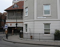
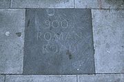
A section of Watling Street still exists in the City of London
close to Mansion House underground station on the route of the original Roman road which traversed the River Thames
via the first London Bridge
and ran through the City in a straight line from London Bridge to Newgate
.
which leads from Manchester to Ribchester
.
The Roman Road from Cataractonium (now Catterick
, North Yorkshire
) to Corstopitum (now Corbridge
, Northumberland
) and on to the Antonine Wall
(also known as Grym's Dyke
or Graham's Dyke, from Grim, a name of Woden
) also came to be known as Watling Street, with perhaps a similar Old English
etymology
owing to its path into the foreign land of Scotland
. This route is also known as Dere Street
. This may also be the case for another Watling Street between Manchester
(Mamucium) and Ribchester
(Bremetennacum
) which ultimately led to another 'foreign land' in Saxon times, that of Rheged
or modern Cumbria
.
A Watling Street Road exists to this day in the city of Preston, Lancashire
. It connects the districts of Ribbleton and Fulwood
and passes the site of Sharoe Green Hospital.
Ancient trackway
Ancient trackway can refer to any track or trail whose origin is lost in antiquity. Such paths existed from the earliest prehistoric times and in every inhabited part of the globe...
in England and Wales
Wales
Wales is a country that is part of the United Kingdom and the island of Great Britain, bordered by England to its east and the Atlantic Ocean and Irish Sea to its west. It has a population of three million, and a total area of 20,779 km²...
that was first used by the Britons
Britons (historical)
The Britons were the Celtic people culturally dominating Great Britain from the Iron Age through the Early Middle Ages. They spoke the Insular Celtic language known as British or Brythonic...
mainly between the modern cities of Canterbury
Canterbury
Canterbury is a historic English cathedral city, which lies at the heart of the City of Canterbury, a district of Kent in South East England. It lies on the River Stour....
and St Albans
St Albans
St Albans is a city in southern Hertfordshire, England, around north of central London, which forms the main urban area of the City and District of St Albans. It is a historic market town, and is now a sought-after dormitory town within the London commuter belt...
. The Romans later paved the route, part of which is identified on the Antonine Itinerary
Antonine Itinerary
The Antonine Itinerary is a register of the stations and distances along the various roads of the Roman empire, containing directions how to get from one Roman settlement to another...
as Iter III: "Item a Londinio ad portum Dubris" - from London to the port of Dover
Dubris
Dubris or Portus Dubris was a town in Roman Britain. It is now Dover, Kent, England.As the closest point to continental Europe and the site of the estuary of the Dour, the site chosen for Dover was ideal for a cross-channel port...
. Its route is now covered by the A2 road
A2 road (Great Britain)
The A2 is a major road in southern England, connecting London with the English Channel port of Dover in Kent. This route has always been of importance as a connection between the British capital of London and sea trade routes to Continental Europe...
from Dover to London, and the A5 road from London to Wroxeter
Wroxeter
Wroxeter is a village in Shropshire, England. It forms part of the civil parish of Wroxeter and Uppington and is located in the Severn Valley about south-east of Shrewsbury.-History:...
.
The name derives from the Old English Wæcelinga Stræt. Originally the word "street" simply meant a paved road
Romano-British road names
There are no records of names used by the Romano-British for their roads, if they used names at all. The few surviving Roman maps and documents, such as the Antonine Itinerary only distinguish roads by the towns which they served...
(Latin: "via strata"), and did not have the modern association with populated areas.
History
British
The Roman road followed the broad, grassy trackway already used by the Britons for many hundreds of years, although the newer road was made to follow a more direct course. It led from RichboroughRichborough
Richborough is a settlement north of Sandwich on the east coast of the county of Kent, England. Richborough lies close to the Isle of Thanet....
in the south-east by way of a ford of the Thames at present-day Westminster
Westminster
Westminster is an area of central London, within the City of Westminster, England. It lies on the north bank of the River Thames, southwest of the City of London and southwest of Charing Cross...
to near Wroxeter
Wroxeter
Wroxeter is a village in Shropshire, England. It forms part of the civil parish of Wroxeter and Uppington and is located in the Severn Valley about south-east of Shrewsbury.-History:...
, where one section went on to Holyhead
Holyhead
Holyhead is the largest town in the county of Anglesey in the North Wales. It is also a major port adjacent to the Irish Sea serving Ireland....
and another, by way of Chester
Chester
Chester is a city in Cheshire, England. Lying on the River Dee, close to the border with Wales, it is home to 77,040 inhabitants, and is the largest and most populous settlement of the wider unitary authority area of Cheshire West and Chester, which had a population of 328,100 according to the...
, on towards Scotland.
Roman
A Roman roadRoman road
The Roman roads were a vital part of the development of the Roman state, from about 500 BC through the expansion during the Roman Republic and the Roman Empire. Roman roads enabled the Romans to move armies and trade goods and to communicate. The Roman road system spanned more than 400,000 km...
recorded in the Antonine Itinerary
Antonine Itinerary
The Antonine Itinerary is a register of the stations and distances along the various roads of the Roman empire, containing directions how to get from one Roman settlement to another...
as "Iter III" linked London and Dover. The last section of the long Iter II route from Hadrian's Wall
Hadrian's Wall
Hadrian's Wall was a defensive fortification in Roman Britain. Begun in AD 122, during the rule of emperor Hadrian, it was the first of two fortifications built across Great Britain, the second being the Antonine Wall, lesser known of the two because its physical remains are less evident today.The...
travelled through Viroconium (now Wroxeter in Shropshire
Shropshire
Shropshire is a county in the West Midlands region of England. For Eurostat purposes, the county is a NUTS 3 region and is one of four counties or unitary districts that comprise the "Shropshire and Staffordshire" NUTS 2 region. It borders Wales to the west...
), past Letocetum
Letocetum
Letocetum is the remains of a Roman settlement. It was an important military staging post and posting station near the junction of Watling Street, the Roman military road to North Wales , and Icknield Street . The site is now within the parish of Wall, Staffordshire, England...
(modern day Wall
Wall, Staffordshire
Wall is a small village and civil parish in Staffordshire, England, just south of Lichfield. It lies on the site of the Roman settlement of Letocetum.The nearby junction of the A5 and A5127 roads and the M6 Toll motorway is often referred to as Wall junction....
) in Staffordshire, Manduessedum
Manduessedum
Manduessedum was a Roman fort and later a civilian small town in the Roman Province of Britannia. Today it is known as Mancetter, located in the English county of Warwickshire.The fort was founded in around c AD 50-AD 60 on the Watling Street Roman road...
(modern day Mancetter
Mancetter
Mancetter is a village and civil parish on the outskirts of Atherstone in North Warwickshire, at the crossing of Watling Street over the River Anker.-History:...
- possible site of Boudica
Boudica
Boudica , also known as Boadicea and known in Welsh as "Buddug" was queen of the British Iceni tribe who led an uprising against the occupying forces of the Roman Empire....
's last battle
Battle
Generally, a battle is a conceptual component in the hierarchy of combat in warfare between two or more armed forces, or combatants. In a battle, each combatant will seek to defeat the others, with defeat determined by the conditions of a military campaign...
), Venonis (modern day High Cross
High Cross, Leicestershire
High Cross is the name given to the former crossroads of the Roman roads of Watling Street and Fosse Way in Leicestershire, England. It is located about a mile west of the village of Claybrooke Magna and was located in the hundred of Guthlaxton...
) in Leicestershire, Bannaventa
Bannaventa
Bannaventa was a Romano British Fortified Town which was situated on the Roman road of Watling Street, which today is known as the A5 trunk road. Bannaventa is northeast of the village of Norton in the English county of Northamptonshire...
near Norton in modern-day Northamptonshire, Lactodurum
Lactodurum
Lactodurum was a town in the Roman province of Britannia. Today it is known as Towcester, located in the English county of Northamptonshire.Towcester lays claim to being the oldest town in Northamptonshire and possibly, because of the antiquity of recent Iron Age finds in the town, to be one of the...
(modern day Towcester
Towcester
Towcester , the Roman town of Lactodorum, is a small town in south Northamptonshire, England.-Etymology:Towcester comes from the Old English Tófe-ceaster. Tófe refers to the River Tove; Bosworth and Toller compare it to the "Scandinavian proper names" Tófi and Tófa...
- near another possible site of Boudica's last battle), then through Stony Stratford
Stony Stratford
Stony Stratford is a constituent town of Milton Keynes and is a civil parish with a town council within the Borough of Milton Keynes. It is in the north west corner of Milton Keynes, bordering Northamptonshire and separated from it by the River Great Ouse...
and Magiovinium (Fenny Stratford
Fenny Stratford
Fenny Stratford is a constituent town of Milton Keynes, ceremonial county of Buckinghamshire, England and in the Civil Parish of Bletchley and Fenny Stratford. Originally an independent town, it was included in the Milton Keynes "designated area" area in 1967...
) in modern-day Milton Keynes
Milton Keynes
Milton Keynes , sometimes abbreviated MK, is a large town in Buckinghamshire, in the south east of England, about north-west of London. It is the administrative centre of the Borough of Milton Keynes...
, Durocobrivis (modern day Dunstable
Dunstable
Dunstable is a market town and civil parish located in Bedfordshire, England. It lies on the eastward tail spurs of the Chiltern Hills, 30 miles north of London. These geographical features form several steep chalk escarpments most noticeable when approaching Dunstable from the north.-Etymology:In...
) in Bedfordshire (where it crosses the even older Icknield Way
Icknield Way
The Icknield Way is an ancient trackway in southern England. It follows the chalk escarpment that includes the Berkshire Downs and Chiltern Hills.-Background:...
), Verulamium
Verulamium
Verulamium was an ancient town in Roman Britain. It was sited in the southwest of the modern city of St Albans in Hertfordshire, Great Britain. A large portion of the Roman city remains unexcavated, being now park and agricultural land, though much has been built upon...
(near modern-day St Albans
St Albans
St Albans is a city in southern Hertfordshire, England, around north of central London, which forms the main urban area of the City and District of St Albans. It is a historic market town, and is now a sought-after dormitory town within the London commuter belt...
in Hertfordshire
Hertfordshire
Hertfordshire is a ceremonial and non-metropolitan county in the East region of England. The county town is Hertford.The county is one of the Home Counties and lies inland, bordered by Greater London , Buckinghamshire , Bedfordshire , Cambridgeshire and...
) and London (by way of the ford at Thorney Island
Thorney Island (London)
Thorney Island was the eyot on the Thames, upstream of mediæval London, where Westminster Abbey and the Palace of Westminster were built...
until London Bridge
London Bridge
London Bridge is a bridge over the River Thames, connecting the City of London and Southwark, in central London. Situated between Cannon Street Railway Bridge and Tower Bridge, it forms the western end of the Pool of London...
was finished, and the line of the modern Old Kent Road
Old Kent Road
The Old Kent Road is a road in South East London, England and forms part of Watling Street, the Roman road which ran from Dover to Holyhead. The street is famous as the equal cheapest property on the London Monopoly board and as the only one in South London....
) to Rutupiae
Rutupiae
Richborough Castle contains the ruined remains of a Roman Saxon Shore Fort. It situated in Richborough near Sandwich, Kent.The site has many phases of Roman remains, collectively known as Richborough Fort or Richborough Roman Fort, still visible today and under the care of English Heritage.Rutupiæ ...
(now Richborough
Richborough
Richborough is a settlement north of Sandwich on the east coast of the county of Kent, England. Richborough lies close to the Isle of Thanet....
in Kent
Kent
Kent is a county in southeast England, and is one of the home counties. It borders East Sussex, Surrey and Greater London and has a defined boundary with Essex in the middle of the Thames Estuary. The ceremonial county boundaries of Kent include the shire county of Kent and the unitary borough of...
) on the southeast coast of England. While another section of Iter II linked Wroxeter to Chester, and other roads were built into north Wales
Wales
Wales is a country that is part of the United Kingdom and the island of Great Britain, bordered by England to its east and the Atlantic Ocean and Irish Sea to its west. It has a population of three million, and a total area of 20,779 km²...
and central Wales, these are not generally considered to be part of Watling Street. Thus the Roman routes which comprise Watling Street are all of Iter III and the middle-southern section of Iter II.
Main section
The main section of the road is that from Dover to Wroxeter. It was namedStreet name
A street name or odonym is an identifying name given to a street. The street name usually forms part of the address...
Wæcelinga Stræt by the Anglo-Saxons, meaning "the paved road pertaining to the people of Wæcel". Wæcel could, possibly, be a variation of the Old English word for 'foreigner' which was applied to the Celt
Celt
The Celts were a diverse group of tribal societies in Iron Age and Roman-era Europe who spoke Celtic languages.The earliest archaeological culture commonly accepted as Celtic, or rather Proto-Celtic, was the central European Hallstatt culture , named for the rich grave finds in Hallstatt, Austria....
ic people inhabiting what is now Wales. This place-name element also gave us the name for Wæclingacaester (the early English name for Verulamium) and it seems likely that the road-name was originally applied first to the section between that town and London before being applied to the entire road.
A number of ancient names that contain the Old English element stræt testify to the ancient route of Watling Street: Boughton Street
Boughton Street
Boughton Street is a village in the borough of Swale in Kent, England. It is located on the erstwhile main road between Faversham and Canterbury , which now bypasses the village. The 13th century parish church of St Peter and Paul stands about a mile away from the main village.In times past,...
, Kent; Colney Street
Colney Street
Colney Street is a village in the English county of Hertfordshire.It lies on the A5183 road, this was formerly the A5 road and, before that, Roman Britain's Watling Street. In addition its northern boundary is delineated by the M25 motorway. These location advantages have led to it becoming a...
, Hertfordshire; Fenny Stratford
Fenny Stratford
Fenny Stratford is a constituent town of Milton Keynes, ceremonial county of Buckinghamshire, England and in the Civil Parish of Bletchley and Fenny Stratford. Originally an independent town, it was included in the Milton Keynes "designated area" area in 1967...
, Stony Stratford
Stony Stratford
Stony Stratford is a constituent town of Milton Keynes and is a civil parish with a town council within the Borough of Milton Keynes. It is in the north west corner of Milton Keynes, bordering Northamptonshire and separated from it by the River Great Ouse...
and Old Stratford
Old Stratford
Old Stratford is a village in the south of the English county of Northamptonshire. The river Great Ouse forms the boundary with Buckinghamshire and Milton Keynes.-Location:...
, all in Buckinghamshire; Stretton under Fosse and Stretton Baskerville
Stretton Baskerville
Stretton Baskerville is a deserted medieval village and civil parish in the English county of Warwickshire.It shares a parish council with the nearby parish of Burton Hastings....
, both in Warwickshire; the three adjacent settlements of All Stretton
All Stretton
All Stretton is a village and civil parish in Shropshire, England.-Geography:All Stretton lies about a mile to the north of the market town of Church Stretton, on the old Shrewsbury Road - the county town is 12 miles to the north. Similarly, the small village of Little Stretton lies to the south...
, Church Stretton
Church Stretton
Church Stretton is a small town and civil parish in Shropshire, England. The population of the town was recorded as 2,789 in 2001, whilst the population of the wider parish was recorded as 4,186...
and Little Stretton
Little Stretton, Shropshire
Little Stretton is a village in Shropshire, England.It lies on the B5477 to the south of the town of Church Stretton ; similarly, the small village of All Stretton lies to the north of Church Stretton on the same road...
in Shropshire; and Stretton Sugwas
Stretton Sugwas
Stretton Sugwas is a village and civil parish in Herefordshire, England, about four miles north-west of Hereford. The parish also includes the village of Swainshill. The Stretton in the name comes from the Roman road which passes east-west through the village.-External links:...
, Herefordshire.
Subsidiary routes
Canterbury
Canterbury is a historic English cathedral city, which lies at the heart of the City of Canterbury, a district of Kent in South East England. It lies on the River Stour....
(the Roman Durovernum) to Lympne
Lympne
Lympne is a village situated on the former sea cliffs above the Romney Marsh in Kent. It lies approximately west of Folkestone, 2 miles west of Hythe and east of Ashford....
(Lemanis) at the western edge of the Romney Marsh
Romney Marsh
Romney Marsh is a sparsely populated wetland area in the counties of Kent and East Sussex in the south-east of England. It covers about 100 mi ² .-Quotations:*“As Egypt was the gift of the Nile, this level tract .....
. Most of it is now the current B2068 road that runs from the M20 motorway
M20 motorway
The M20 is a motorway in Kent, England. It runs from the M25 motorway to Folkestone, providing a link to the Channel Tunnel and the ports at Dover. It is long...
to Canterbury
Canterbury
Canterbury is a historic English cathedral city, which lies at the heart of the City of Canterbury, a district of Kent in South East England. It lies on the River Stour....
.
Another Stone Street from Magnis
Magnis (Kenchester)
Magnis was a Romano-British town and an important market centre for the British Dobunni tribe, located near modern-day Kenchester in Herefordshire, England...
(Kenchester) in modern Herefordshire
Herefordshire
Herefordshire is a historic and ceremonial county in the West Midlands region of England. For Eurostat purposes it is a NUTS 3 region and is one of three counties that comprise the "Herefordshire, Worcestershire and Gloucestershire" NUTS 2 region. It also forms a unitary district known as the...
to Caerleon
Caerleon
Caerleon is a suburban village and community, situated on the River Usk in the northern outskirts of the city of Newport, South Wales. Caerleon is a site of archaeological importance, being the site of a notable Roman legionary fortress, Isca Augusta, and an Iron Age hill fort...
, Isca Augusta
Isca Augusta
Isca Augusta was a Roman legionary fortress and settlement, the remains of which lie beneath parts of the present-day village of Caerleon on the northern outskirts of the city of Newport in South Wales.-Name:...
and the main Roman legion
Roman legion
A Roman legion normally indicates the basic ancient Roman army unit recruited specifically from Roman citizens. The organization of legions varied greatly over time but they were typically composed of perhaps 5,000 soldiers, divided into maniples and later into "cohorts"...
ary base in the south of Roman Wales.
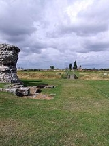
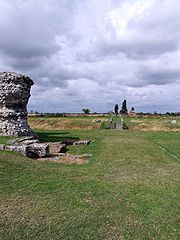
Battle of Watling Street
Part of the route was the site of the Roman victory at the Battle of Watling StreetBattle of Watling Street
The Battle of Watling Street took place in Roman-occupied Britain in AD 60 or 61 between an alliance of indigenous British peoples led by Boudica and a Roman army led by Gaius Suetonius Paulinus. Although outnumbered, the Romans decisively defeated the allied tribes, inflicting heavy losses on them...
in 61 AD between the Roman governor Gaius Suetonius Paulinus
Gaius Suetonius Paulinus
Gaius Suetonius Paulinus, also spelled Paullinus, was a Roman general best known as the commander who defeated the rebellion of Boudica.-Career:...
and the Briton leader Boudica
Boudica
Boudica , also known as Boadicea and known in Welsh as "Buddug" was queen of the British Iceni tribe who led an uprising against the occupying forces of the Roman Empire....
.
Danelaw
In the 9th century, Watling Street was used as the demarcation line between the Anglo-Saxon and Danish-ruled parts of England. The Treaty of WedmoreTreaty of Wedmore
The Peace of Wedmore is a term used by historians for an event referred to by the monk Asser in his Life of Alfred, outlining how in 878 the Viking leader Guthrum was baptised and accepted Alfred as his adoptive father. Guthrum agreed to leave Wessex and a "Treaty of Wedmore" is often assumed by...
required the defeated Danes to withdraw to an area north and east of Watling Street, thus establishing the Danelaw
Danelaw
The Danelaw, as recorded in the Anglo-Saxon Chronicle , is a historical name given to the part of England in which the laws of the "Danes" held sway and dominated those of the Anglo-Saxons. It is contrasted with "West Saxon law" and "Mercian law". The term has been extended by modern historians to...
.
Chaucer's Pilgrims
Like most of the Roman road network, the Roman paving fell into disrepair when the Romans left Britain, although the route continued to be used for centuries afterwards. It is likely that Chaucer's pilgrims used Watling Street to travel from SouthwarkSouthwark
Southwark is a district of south London, England, and the administrative headquarters of the London Borough of Southwark. Situated east of Charing Cross, it forms one of the oldest parts of London and fronts the River Thames to the north...
to Canterbury
Canterbury
Canterbury is a historic English cathedral city, which lies at the heart of the City of Canterbury, a district of Kent in South East England. It lies on the River Stour....
in his Canterbury Tales.
Turnpike
The road north of London became a TurnpikeTurnpike trust
Turnpike trusts in the United Kingdom were bodies set up by individual Acts of Parliament, with powers to collect road tolls for maintaining the principal highways in Britain from the 17th but especially during the 18th and 19th centuries...
firstly in 1707 when the section from Fourne hill north of Hockliffe
Hockliffe
Hockliffe is a village and civil parish in Bedfordshire on the crossroads of the A5 road which lies upon the course of the roman road known as Watling Street and the A4012 road.It is about four miles east of Leighton Buzzard...
to Stony Stratford
Stony Stratford
Stony Stratford is a constituent town of Milton Keynes and is a civil parish with a town council within the Borough of Milton Keynes. It is in the north west corner of Milton Keynes, bordering Northamptonshire and separated from it by the River Great Ouse...
was paved following an Act of Parliament on March 4, 1707.
This was the first Turnpike Trust and showed how financially hazardous the undertaking could be.
The Fourne hill to Stony Stratford case provides more evidence that Parliament would void undertakers’ rights if they were negligent. The trustees for the Fourne hill to Stony Stratford road borrowed more than 7000 pounds in 1707 and 1708 to improve the road. The creditors, however, claim to have been misinformed regarding the expected revenues from the tolls, and requested in 1709 that a new act extend the term and increase the tolls. A new act was passed in 1709 extending the term, but the tolls were not increased. It also included a provision that the creditors could take receivership of the tolls if the trustees had not repaid their debts by 1711.
Apparently, the trustees were unable to borrow and the creditors took over the tolls. In 1716,
Parliament tried to clarify the situation by passing an act that vested authority in the trustees from the 1709 act and another group appointed by the Justices of the Peace for Buckinghamshire.
The 1716 act was not amended for its entire term of 23 years, but once it was set to expire,
Parliament decided that it would not renew the rights of the existing trustees for the Fourne hill to Stony Stratford road. In 1736, the trustees submitted a petition for an extension of their rights, but it failed to pass and in 1739 their authority ended. In 1740, a new act was passed naming a replacement body of trustees. In the petition for the new bill, the inhabitants of Buckinghamshire described the road as being ‘ruined.’ This sentiment was affirmed by the
Member heading the committee for the bill.
The road was re-paved in the early 19th century by Thomas Telford
Thomas Telford
Thomas Telford FRS, FRSE was a Scottish civil engineer, architect and stonemason, and a noted road, bridge and canal builder.-Early career:...
who brought it back into use as a turnpike road for use by mail coaches bringing mail to and from Ireland
Ireland
Ireland is an island to the northwest of continental Europe. It is the third-largest island in Europe and the twentieth-largest island on Earth...
, his road being extended to the port of Holyhead
Holyhead
Holyhead is the largest town in the county of Anglesey in the North Wales. It is also a major port adjacent to the Irish Sea serving Ireland....
on the Isle of Anglesey in Wales
Wales
Wales is a country that is part of the United Kingdom and the island of Great Britain, bordered by England to its east and the Atlantic Ocean and Irish Sea to its west. It has a population of three million, and a total area of 20,779 km²...
. At this time the section south of London became known as the Great Dover Road. The toll system ended in 1875.
Modern road
Most of the road is still in use today, apart from a few sections where it has been diverted. The stretch of the road between London and Dover is today known as the A2
A2 road (Great Britain)
The A2 is a major road in southern England, connecting London with the English Channel port of Dover in Kent. This route has always been of importance as a connection between the British capital of London and sea trade routes to Continental Europe...
, and the stretch between London and Shrewsbury
Shrewsbury
Shrewsbury is the county town of Shropshire, in the West Midlands region of England. Lying on the River Severn, it is a civil parish home to some 70,000 inhabitants, and is the primary settlement and headquarters of Shropshire Council...
is today known as the A5 (which now continues to Holyhead
Holyhead
Holyhead is the largest town in the county of Anglesey in the North Wales. It is also a major port adjacent to the Irish Sea serving Ireland....
). The sections of the road which pass through Central London are known by a variety of names, including Edgware Road and Maida Vale
Maida Vale
Maida Vale is a residential district in West London between St John's Wood and Kilburn. It is part of the City of Westminster. The area is mostly residential, and mainly affluent, consisting of many large late Victorian and Edwardian blocks of mansion flats...
. At Blackheath
Blackheath, London
Blackheath is a district of South London, England. It is named from the large open public grassland which separates it from Greenwich to the north and Lewisham to the west...
the Roman road ran along Old Dover Road, then turning and running through Greenwich Park to head to a location perhaps a little north of the existing Deptford Bridge. Through Milton Keynes
Milton Keynes
Milton Keynes , sometimes abbreviated MK, is a large town in Buckinghamshire, in the south east of England, about north-west of London. It is the administrative centre of the Borough of Milton Keynes...
, the A5 is diverted onto a new dual-carriageway and Watling Street forms part of the new town's grid system and carries the additional designation V4.
Continued use of the name along the ancient road
The use of the street name is retained along the ancient road in many places: for instance, in BexleyheathBexleyheath
Bexleyheath is a main suburban district of Southeast London, England, in the London Borough of Bexley with a small percentage of the district itself being in the London Borough of Greenwich. Bexleyheath is located on the border of Inner London and Outer London. It is east south-east of Charing Cross...
in Southeast London and on into Kent
Kent
Kent is a county in southeast England, and is one of the home counties. It borders East Sussex, Surrey and Greater London and has a defined boundary with Essex in the middle of the Thames Estuary. The ceremonial county boundaries of Kent include the shire county of Kent and the unitary borough of...
(including the towns of Canterbury
Canterbury
Canterbury is a historic English cathedral city, which lies at the heart of the City of Canterbury, a district of Kent in South East England. It lies on the River Stour....
, Gillingham, Rochester, Gravesend
Gravesend, Kent
Gravesend is a town in northwest Kent, England, on the south bank of the Thames, opposite Tilbury in Essex. It is the administrative town of the Borough of Gravesham and, because of its geographical position, has always had an important role to play in the history and communications of this part of...
and Dartford
Dartford
Dartford is the principal town in the borough of Dartford. It is situated in the northwest corner of Kent, England, east south-east of central London....
). Also, in London, a major road joining the A5 in north west London is called Watling Avenue. North of London, the name Watling Street still occurs in Hertfordshire
Hertfordshire
Hertfordshire is a ceremonial and non-metropolitan county in the East region of England. The county town is Hertford.The county is one of the Home Counties and lies inland, bordered by Greater London , Buckinghamshire , Bedfordshire , Cambridgeshire and...
(including St Albans
St Albans
St Albans is a city in southern Hertfordshire, England, around north of central London, which forms the main urban area of the City and District of St Albans. It is a historic market town, and is now a sought-after dormitory town within the London commuter belt...
), Bedfordshire
Bedfordshire
Bedfordshire is a ceremonial county of historic origin in England that forms part of the East of England region.It borders Cambridgeshire to the north-east, Northamptonshire to the north, Buckinghamshire to the west and Hertfordshire to the south-east....
, Buckinghamshire
Buckinghamshire
Buckinghamshire is a ceremonial and non-metropolitan home county in South East England. The county town is Aylesbury, the largest town in the ceremonial county is Milton Keynes and largest town in the non-metropolitan county is High Wycombe....
(including Milton Keynes
Milton Keynes
Milton Keynes , sometimes abbreviated MK, is a large town in Buckinghamshire, in the south east of England, about north-west of London. It is the administrative centre of the Borough of Milton Keynes...
), Northamptonshire
Northamptonshire
Northamptonshire is a landlocked county in the English East Midlands, with a population of 629,676 as at the 2001 census. It has boundaries with the ceremonial counties of Warwickshire to the west, Leicestershire and Rutland to the north, Cambridgeshire to the east, Bedfordshire to the south-east,...
(including Towcester
Towcester
Towcester , the Roman town of Lactodorum, is a small town in south Northamptonshire, England.-Etymology:Towcester comes from the Old English Tófe-ceaster. Tófe refers to the River Tove; Bosworth and Toller compare it to the "Scandinavian proper names" Tófi and Tófa...
), Leicestershire
Leicestershire
Leicestershire is a landlocked county in the English Midlands. It takes its name from the heavily populated City of Leicester, traditionally its administrative centre, although the City of Leicester unitary authority is today administered separately from the rest of Leicestershire...
, Warwickshire
Warwickshire
Warwickshire is a landlocked non-metropolitan county in the West Midlands region of England. The county town is Warwick, although the largest town is Nuneaton. The county is famous for being the birthplace of William Shakespeare...
(including Nuneaton
Nuneaton
Nuneaton is the largest town in the Borough of Nuneaton and Bedworth and in the English county of Warwickshire.Nuneaton is most famous for its associations with the 19th century author George Eliot, who was born on a farm on the Arbury Estate just outside Nuneaton in 1819 and lived in the town for...
), Staffordshire
Staffordshire
Staffordshire is a landlocked county in the West Midlands region of England. For Eurostat purposes, the county is a NUTS 3 region and is one of four counties or unitary districts that comprise the "Shropshire and Staffordshire" NUTS 2 region. Part of the National Forest lies within its borders...
(including Cannock
Cannock
Cannock is the most populous of three towns in the district of Cannock Chase in the central southern part of the county of Staffordshire in the West Midlands region of England....
, Wall
Letocetum
Letocetum is the remains of a Roman settlement. It was an important military staging post and posting station near the junction of Watling Street, the Roman military road to North Wales , and Icknield Street . The site is now within the parish of Wall, Staffordshire, England...
and Lichfield
Lichfield
Lichfield is a cathedral city, civil parish and district in Staffordshire, England. One of eight civil parishes with city status in England, Lichfield is situated roughly north of Birmingham...
), Shropshire
Shropshire
Shropshire is a county in the West Midlands region of England. For Eurostat purposes, the county is a NUTS 3 region and is one of four counties or unitary districts that comprise the "Shropshire and Staffordshire" NUTS 2 region. It borders Wales to the west...
(including in Church Stretton
Church Stretton
Church Stretton is a small town and civil parish in Shropshire, England. The population of the town was recorded as 2,789 in 2001, whilst the population of the wider parish was recorded as 4,186...
as the residential Watling St North and South) and Gwynedd
Gwynedd
Gwynedd is a county in north-west Wales, named after the old Kingdom of Gwynedd. Although the second biggest in terms of geographical area, it is also one of the most sparsely populated...
.
A section of Watling Street still exists in the City of London
City of London
The City of London is a small area within Greater London, England. It is the historic core of London around which the modern conurbation grew and has held city status since time immemorial. The City’s boundaries have remained almost unchanged since the Middle Ages, and it is now only a tiny part of...
close to Mansion House underground station on the route of the original Roman road which traversed the River Thames
River Thames
The River Thames flows through southern England. It is the longest river entirely in England and the second longest in the United Kingdom. While it is best known because its lower reaches flow through central London, the river flows alongside several other towns and cities, including Oxford,...
via the first London Bridge
London Bridge
London Bridge is a bridge over the River Thames, connecting the City of London and Southwark, in central London. Situated between Cannon Street Railway Bridge and Tower Bridge, it forms the western end of the Pool of London...
and ran through the City in a straight line from London Bridge to Newgate
Newgate
Newgate at the west end of Newgate Street was one of the historic seven gates of London Wall round the City of London and one of the six which date back to Roman times. From it a Roman road led west to Silchester...
.
Other Watling Streets
In Lancashire, Watling Street is the Roman Road through AffetsideAffetside
Affetside is an upland village located in the West Pennine Moors area, in the Metropolitan Borough of Bury, in Greater Manchester, bordering Bolton in North West England. Historically, it was part of Lancashire. It is also in the Local Council Ward of Tottington, and is situated in the Bury North...
which leads from Manchester to Ribchester
Ribchester
Ribchester is a village and civil parish within the Ribble Valley district of Lancashire, England. It lies on the banks of the River Ribble, northwest of Blackburn and east of Preston.The village has a long history with evidence of Bronze Age beginnings...
.
The Roman Road from Cataractonium (now Catterick
Catterick, North Yorkshire
Catterick , sometimes Catterick Village, to distinguish it from the nearby Catterick Garrison, is a village and civil parish in the Richmondshire district of North Yorkshire, England...
, North Yorkshire
North Yorkshire
North Yorkshire is a non-metropolitan or shire county located in the Yorkshire and the Humber region of England, and a ceremonial county primarily in that region but partly in North East England. Created in 1974 by the Local Government Act 1972 it covers an area of , making it the largest...
) to Corstopitum (now Corbridge
Corbridge
Corbridge is a village in Northumberland, England, situated west of Newcastle and east of Hexham. Villages in the vicinity include Halton, Acomb, Aydon and Sandhoe.-Roman fort and town:...
, Northumberland
Northumberland
Northumberland is the northernmost ceremonial county and a unitary district in North East England. For Eurostat purposes Northumberland is a NUTS 3 region and is one of three boroughs or unitary districts that comprise the "Northumberland and Tyne and Wear" NUTS 2 region...
) and on to the Antonine Wall
Antonine Wall
The Antonine Wall is a stone and turf fortification built by the Romans across what is now the Central Belt of Scotland, between the Firth of Forth and the Firth of Clyde. Representing the northernmost frontier barrier of the Roman Empire, it spanned approximately 39 miles and was about ten feet ...
(also known as Grym's Dyke
Grim's Ditch
Grim's Ditch, Grim's Dyke or Grim's Bank is a name shared by a number of prehistoric bank and ditch earthworks...
or Graham's Dyke, from Grim, a name of Woden
Woden
Woden or Wodan is a major deity of Anglo-Saxon and Continental Germanic polytheism. Together with his Norse counterpart Odin, Woden represents a development of the Proto-Germanic god *Wōdanaz....
) also came to be known as Watling Street, with perhaps a similar Old English
Old English language
Old English or Anglo-Saxon is an early form of the English language that was spoken and written by the Anglo-Saxons and their descendants in parts of what are now England and southeastern Scotland between at least the mid-5th century and the mid-12th century...
etymology
Etymology
Etymology is the study of the history of words, their origins, and how their form and meaning have changed over time.For languages with a long written history, etymologists make use of texts in these languages and texts about the languages to gather knowledge about how words were used during...
owing to its path into the foreign land of Scotland
Scotland
Scotland is a country that is part of the United Kingdom. Occupying the northern third of the island of Great Britain, it shares a border with England to the south and is bounded by the North Sea to the east, the Atlantic Ocean to the north and west, and the North Channel and Irish Sea to the...
. This route is also known as Dere Street
Dere Street
Dere Street or Deere Street, was a Roman road between Eboracum and Veluniate, in what is now Scotland. It still exists in the form of the route of many major roads, including the A1 and A68 just north of Corbridge.Its name corresponds with the post Roman Anglo-Saxon kingdom of Deira, through...
. This may also be the case for another Watling Street between Manchester
Manchester
Manchester is a city and metropolitan borough in Greater Manchester, England. According to the Office for National Statistics, the 2010 mid-year population estimate for Manchester was 498,800. Manchester lies within one of the UK's largest metropolitan areas, the metropolitan county of Greater...
(Mamucium) and Ribchester
Ribchester
Ribchester is a village and civil parish within the Ribble Valley district of Lancashire, England. It lies on the banks of the River Ribble, northwest of Blackburn and east of Preston.The village has a long history with evidence of Bronze Age beginnings...
(Bremetennacum
Bremetennacum
Bremetennacum was a Roman fort which is now the village of Ribchester in Lancashire . The site is a Scheduled Ancient Monument. The first Roman activity on the site was the establishment of a timber fort believed to have been constructed during the campaigns of Petillius Cerialis around AD 72/3...
) which ultimately led to another 'foreign land' in Saxon times, that of Rheged
Rheged
Rheged is described in poetic sources as one of the kingdoms of the Hen Ogledd , the Brythonic-speaking region of what is now northern England and southern Scotland, during the Early Middle Ages...
or modern Cumbria
Cumbria
Cumbria , is a non-metropolitan county in North West England. The county and Cumbria County Council, its local authority, came into existence in 1974 after the passage of the Local Government Act 1972. Cumbria's largest settlement and county town is Carlisle. It consists of six districts, and in...
.
A Watling Street Road exists to this day in the city of Preston, Lancashire
Lancashire
Lancashire is a non-metropolitan county of historic origin in the North West of England. It takes its name from the city of Lancaster, and is sometimes known as the County of Lancaster. Although Lancaster is still considered to be the county town, Lancashire County Council is based in Preston...
. It connects the districts of Ribbleton and Fulwood
Fulwood, Lancashire
Fulwood is an unparished area of the City of Preston, Lancashire, England, about north of the city centre. It had a population of 33,171 in 2001.- Economy and society :Fulwood remains a distinctive division of Preston...
and passes the site of Sharoe Green Hospital.
See also
- Great Dover Road
- Roman BritainRoman BritainRoman Britain was the part of the island of Great Britain controlled by the Roman Empire from AD 43 until ca. AD 410.The Romans referred to the imperial province as Britannia, which eventually comprised all of the island of Great Britain south of the fluid frontier with Caledonia...
- Roman roads in BritainRoman roads in BritainRoman roads, together with Roman aqueducts and the vast standing Roman army , constituted the three most impressive features of the Roman Empire. In Britain, as in other provinces, the Romans constructed a comprehensive network of paved trunk roads Roman roads, together with Roman aqueducts and the...
- Fenny StratfordFenny StratfordFenny Stratford is a constituent town of Milton Keynes, ceremonial county of Buckinghamshire, England and in the Civil Parish of Bletchley and Fenny Stratford. Originally an independent town, it was included in the Milton Keynes "designated area" area in 1967...
(Magiovinium) - TowcesterTowcesterTowcester , the Roman town of Lactodorum, is a small town in south Northamptonshire, England.-Etymology:Towcester comes from the Old English Tófe-ceaster. Tófe refers to the River Tove; Bosworth and Toller compare it to the "Scandinavian proper names" Tófi and Tófa...
(Lactodorum) - BannaventaBannaventaBannaventa was a Romano British Fortified Town which was situated on the Roman road of Watling Street, which today is known as the A5 trunk road. Bannaventa is northeast of the village of Norton in the English county of Northamptonshire...
- TripontiumTripontiumTripontium was a town in Roman Britain. It lay on the Roman road later called Watling Street at a site now chiefly within the civil parish of Newton and Biggin in the English county of Warwickshire and partly in Leicestershire, some 3.4 miles north-east of Rugby and 3.1 miles south of...
- ManduessedumManduessedumManduessedum was a Roman fort and later a civilian small town in the Roman Province of Britannia. Today it is known as Mancetter, located in the English county of Warwickshire.The fort was founded in around c AD 50-AD 60 on the Watling Street Roman road...
External links
- The Antonine Itinerary
- 'Watling Street - A Journey through Roman Britain' web page by the BBCBBCThe British Broadcasting Corporation is a British public service broadcaster. Its headquarters is at Broadcasting House in the City of Westminster, London. It is the largest broadcaster in the world, with about 23,000 staff...
- Stone Street, Suffolk - Thayer