
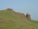
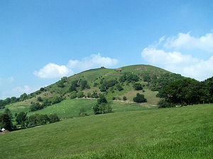
Caer Caradoc Hill
Encyclopedia
Hill
A hill is a landform that extends above the surrounding terrain. Hills often have a distinct summit, although in areas with scarp/dip topography a hill may refer to a particular section of flat terrain without a massive summit A hill is a landform that extends above the surrounding terrain. Hills...
in the English county
Counties of England
Counties of England are areas used for the purposes of administrative, geographical and political demarcation. For administrative purposes, England outside Greater London and the Isles of Scilly is divided into 83 counties. The counties may consist of a single district or be divided into several...
of Shropshire
Shropshire
Shropshire is a county in the West Midlands region of England. For Eurostat purposes, the county is a NUTS 3 region and is one of four counties or unitary districts that comprise the "Shropshire and Staffordshire" NUTS 2 region. It borders Wales to the west...
. It overlooks the town of Church Stretton
Church Stretton
Church Stretton is a small town and civil parish in Shropshire, England. The population of the town was recorded as 2,789 in 2001, whilst the population of the wider parish was recorded as 4,186...
and the village of All Stretton
All Stretton
All Stretton is a village and civil parish in Shropshire, England.-Geography:All Stretton lies about a mile to the north of the market town of Church Stretton, on the old Shrewsbury Road - the county town is 12 miles to the north. Similarly, the small village of Little Stretton lies to the south...
and offers panoramic views to the north towards The Wrekin
The Wrekin
The Wrekin is a hill in east Shropshire, England. It is located some west of Telford, on the border between the unitary authorities of Shropshire and Telford and Wrekin. Rising to a height of above the Shropshire Plain, it is a prominent and well-known landmark, marking the entrance to Shropshire...
, east to Wenlock Edge
Wenlock Edge
Wenlock Edge is a limestone escarpment near Much Wenlock, Shropshire, England. It is long and runs from South West to North East between Craven Arms and Much Wenlock. It is roughly 330 metres high...
, and west over the nearby Long Mynd
Long Mynd
The Long Mynd in Shropshire, England, is a part of the Shropshire Hills Area of Outstanding Natural Beauty. It is south of the county town Shrewsbury, and has an area of over 22 square kilometres , most of which takes the form of a heathland plateau. Most of the land on the Long Mynd is owned by...
. On a clear day it is possible to see the hills of north-east Wales
Wales
Wales is a country that is part of the United Kingdom and the island of Great Britain, bordered by England to its east and the Atlantic Ocean and Irish Sea to its west. It has a population of three million, and a total area of 20,779 km²...
to the north, the high-rise buildings of Birmingham
Birmingham
Birmingham is a city and metropolitan borough in the West Midlands of England. It is the most populous British city outside the capital London, with a population of 1,036,900 , and lies at the heart of the West Midlands conurbation, the second most populous urban area in the United Kingdom with a...
to the east, Worcester Beacon in the Malvern Hills
Malvern Hills
The Malvern Hills are a range of hills in the English counties of Worcestershire, Herefordshire and a small area of northern Gloucestershire, dominating the surrounding countryside and the towns and villages of the district of Malvern...
to the south-east, and Hay Bluff
Twmpa
Twmpa or Lord Hereford's Knob is a mountain in south-east Wales, forming a part of the great northwest scarp of the Black Mountains. It lies 3 km west of the border with England, and around 7 km south of Hay-on-Wye. To the northeast lies the Gospel Pass through which runs a minor road...
in the Black Mountains, Wales
Black Mountains, Wales
The Black Mountains are a group of hills spread across parts of Powys and Monmouthshire in southeast Wales, and extending across the national border into Herefordshire, England. They are the easternmost of the four ranges of hills that comprise the Brecon Beacons National Park, and are frequently...
and the peaks of the Brecon Beacons
Brecon Beacons
The Brecon Beacons is a mountain range in South Wales. In a narrow sense, the name refers to the range of popular peaks south of Brecon, including South Wales' highest mountain, Pen y Fan, and which together form the central section of the Brecon Beacons National Park...
, to the south. Caer Caradoc is hill G/WB-006 in Summits on the Air
Summits on the Air
Summits On The Air is an amateur radio operating award program. Its aim is to encourage operation from mountainous locations. Licensed amateur radio operators combine mountain climbing with operating their radios from the summits of hills and mountains.Those who set up a station on a summit are...
. This Caer Caradoc is not to be confused with the Caer Caradoc 1km to the west of Chapel Lawn village near Bucknell.
Caer Caradoc rises sharply and steeply up out of the narrow valley in which the town of Church Stretton
Church Stretton
Church Stretton is a small town and civil parish in Shropshire, England. The population of the town was recorded as 2,789 in 2001, whilst the population of the wider parish was recorded as 4,186...
is situated, known as the Stretton Gap. It is the highest point on a high, narrow, northeast–southwest "whaleback ridge", sometimes called a hogsback ridge. The Wrekin
The Wrekin
The Wrekin is a hill in east Shropshire, England. It is located some west of Telford, on the border between the unitary authorities of Shropshire and Telford and Wrekin. Rising to a height of above the Shropshire Plain, it is a prominent and well-known landmark, marking the entrance to Shropshire...
is a very similarly shaped hill and on the same alignment, some 10 miles (16.1 km) to the north-east. Caer Caradoc may be fairly easily climbed from Church Stretton town but the ascent / descent is steep; a more gentle climb is from the village of Cardington
Cardington
Cardington may refer to:*Cardington, Bedfordshire, a village and civil parish in England*Cardington, Shropshire, a village and civil parish in England*Cardington, Ohio, a village in the United States...
, which lies two miles (3 km) to the east. A good way of climbing Caer Caradoc is to do a linear walk from along the aforementioned ridge, including the nearby summits of Ragleth Hill and The Lawley to gain the best perspective on each http://www.geograph.org.uk/photo/619707. Otherwise, the ascent of the hill and return is some 7 miles (11.3 km) from the town.
The hill is volcanic in origin, like the Wrekin etc., formed of narrow ridges of resistant Pre-Cambrian rock, thrust upwards by movements deep down along the Church Stretton fault. This fault runs from Staffordshire
Staffordshire
Staffordshire is a landlocked county in the West Midlands region of England. For Eurostat purposes, the county is a NUTS 3 region and is one of four counties or unitary districts that comprise the "Shropshire and Staffordshire" NUTS 2 region. Part of the National Forest lies within its borders...
to South Wales
South Wales
South Wales is an area of Wales bordered by England and the Bristol Channel to the east and south, and Mid Wales and West Wales to the north and west. The most densely populated region in the south-west of the United Kingdom, it is home to around 2.1 million people and includes the capital city of...
and can be seen on OS
Ordnance Survey
Ordnance Survey , an executive agency and non-ministerial government department of the Government of the United Kingdom, is the national mapping agency for Great Britain, producing maps of Great Britain , and one of the world's largest producers of maps.The name reflects its creation together with...
maps as a line of springs on this hill.

Brython
The Britons were the Celtic people culturally dominating Great Britain from the Iron Age through the Early Middle Ages. They spoke the Insular Celtic language known as British or Brythonic...
Iron Age
Iron Age
The Iron Age is the archaeological period generally occurring after the Bronze Age, marked by the prevalent use of iron. The early period of the age is characterized by the widespread use of iron or steel. The adoption of such material coincided with other changes in society, including differing...
or late Bronze Age
Bronze Age
The Bronze Age is a period characterized by the use of copper and its alloy bronze as the chief hard materials in the manufacture of some implements and weapons. Chronologically, it stands between the Stone Age and Iron Age...
hill fort
Hill fort
A hill fort is a type of earthworks used as a fortified refuge or defended settlement, located to exploit a rise in elevation for defensive advantage. They are typically European and of the Bronze and Iron Ages. Some were used in the post-Roman period...
. It is this which the hill is named after - Caer Caradog in Welsh
Welsh language
Welsh is a member of the Brythonic branch of the Celtic languages spoken natively in Wales, by some along the Welsh border in England, and in Y Wladfa...
meaning Caradog's fort. Local legend has it that this was the site of the last stand
Battle of Caer Caradoc
The Battle of Caer Caradoc was the final battle in Caratacus's resistance to Roman rule. Fought in 50, the Romans defeated the Britons and thus secured the southern areas of the province of Britannia....
of Caractacus against the Roman legion
Roman legion
A Roman legion normally indicates the basic ancient Roman army unit recruited specifically from Roman citizens. The organization of legions varied greatly over time but they were typically composed of perhaps 5,000 soldiers, divided into maniples and later into "cohorts"...
s during the Roman conquest of Britain
Roman conquest of Britain
The Roman conquest of Britain was a gradual process, beginning effectively in AD 43 under Emperor Claudius, whose general Aulus Plautius served as first governor of Britannia. Great Britain had already frequently been the target of invasions, planned and actual, by forces of the Roman Republic and...
, and that after the battle he hid in the cave near its summit. Others say his last stand was in the locality but that this was one of his fortresses.