
Caversham, New Zealand
Encyclopedia
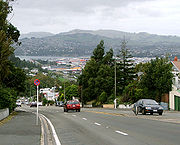
Caversham is one of the older suburbs of the South Island
New Zealand
city of Dunedin
. It is sited at the western edge of the city's central plain at the mouth of the steep Caversham Valley, which rises to the saddle of Lookout Point. Major road and rail routes south lie nearby; the South Island Main Trunk railway runs through the suburb, and a bypass
skirts its main retail area, connecting Dunedin's one-way street system with the Dunedin Southern Motorway
. The suburb is linked by several bus routes to its neighbouring suburbs and central Dunedin.
The suburb was founded by wealthy pioneer William Henry Valpy
, and its name reflects his family connections with the town of Reading
, in the English
county of Berkshire
. Caversham grew rapidly during the Central Otago Gold Rush
of the 1860s because of its location on routes south to the Otago
hinterland. By the end of the 19th century, Caversham was heavily industrialised, and its population included many skilled or semi-skilled tradespeople. This, combined with the community's strong Protestant roots, led to the area's generally left-leaning political stance. Caversham's early history has been the subject of the Caversham Project, a major historical and archaeological study by the University of Otago
. Caversham was a separate borough until 1904, when it was amalgamated with Dunedin city. It is currently administered as part of the city's South Dunedin ward. At a national level, it is part of the Dunedin South
electorate.
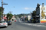
Caversham is now predominantly residential, with some industrial premises in the east (notably the Hillside Railway Workshops) and a retail district centred on South Road and Hillside Road. Residents are generally of low socio-economic status. Caversham's notable buildings include the heritage listed
Lisburn House and several prominent church buildings. Another landmark is the suburb's war memorial, which is the main gate of Caversham School, one of the suburb's two primary schools. Caversham also contains a special needs school
. The nearest secondary schools are located in St Clair, 1 kilometre (0.621372736649807 mi) to the south.
Caversham has strong sporting connections, and is the location of Carisbrook
, one of the city's main sports venues. The suburb is home to the Southern Rugby Football Club, and gives its name to Caversham Football Club
. Several notable sportspeople have associations with Caversham, among them Test cricket
er Clarrie Grimmett
and father and son rugby union
administrators "Old Vic"
and "Young Vic" Cavanagh
. Other notable people with Caversham connections include politician Thomas Kay Sidey, architect Edmund Anscombe
, and surveyor John Turnbull Thomson
.
's main urban area, 4 kilometres (2.5 mi) southwest of the city centre, and 2 kilometres (1.2 mi) north of the Pacific
coast at St Clair
. To the south lies Calton Hill, a spur of Forbury Hill, on which the suburbs of Calton Hill, Corstorphine
and Kew are located.
The suburbs of Balaclava and Maryhill
lie to the north, close to the western end of the ridge that runs along the northern edge of central Dunedin. These hills were all once part of the rim of the Dunedin volcano, the long-extinct crater of which now forms Otago Harbour
. Other suburbs nearby include Forbury, South Dunedin
, Kensington, and Lookout Point.
Caversham Valley has long been the major route out of the central city to the south. The suburb is located close to the start of the Dunedin Southern Motorway
(part of State Highway 1
), the main road access to central Dunedin from the south, and close to the South Island Main Trunk railway.
The railway provides the suburb's most important industry, through the Hillside Railway Workshops, which are located in the southeast of the suburb and in the adjoining suburb of South Dunedin
. Despite this, there are no longer any public railway stations or halts in Caversham, the last station having closed in 1962.
The hill slopes to the north of Caversham are less densely populated, and still retain some tree cover. This, along with the steepness of the land, forms a natural barrier between Caversham and the suburb of Maryhill. Only a few winding roads traverse this barrier, most notably Glen Road, at the eastern end of Caversham. At this end, the suburb draws close to the foot of the hills, and a natural valley, known locally as "The Glen", provides easier road access to the hill ridge.
To the northeast of the Glen, a hill spur including a 20 metres (65.6 ft) cliff separates Caversham from the central part of the city. Though the name is rarely used, this spur is called Montecillo Ridge, named for the mansion of early settler W.H. Reynolds. It is occasionally referred to as "Hillside", after the house of the city's founding father Captain William Cargill
which was located here. This ridge overlooks "The Flat", as the plain stretching across to the Pacific coast was (and is still) locally known. South Road winds around the spur, connecting with the southern end of Princes Street
. One of the city's older and more historic cemeteries, Dunedin Southern Cemetery
, lies on the inner city side of this spur.
 At the top of Caversham Valley are a ridge
and the saddle of Lookout Point. Lookout Point commands views to the southwest past the outer suburbs of Burnside
and Green Island
to Saddle Hill
, as well as providing a view to the east across the southern part of the central city to Otago Harbour and the Otago Peninsula
.
The Māori
name for Lookout Point is Ko Raka-a-runga-te-raki. It was the burial site of chief Rangi-Ihia, a late 18th century Kati Mamoe
chief who was largely responsible for joining the Kai Tahu and Kati Mamoe iwi
. He was buried here so that "his spirit might see thence his old haunts to the southward."
The most prominent building in Lookout Point is the local fire station, which also serves both Caversham and Green Island. This 1956 structure is located immediately to the north of the saddle and is a prominent landmark upon entering or leaving Dunedin. The Dunedin Southern Motorway
officially begins at the Lookout Point saddle, between Calton Hill and Maryhill, and sweeps down over broken hill country past Green Island to Mosgiel
and the Taieri Plains
.
Lookout Point is also the home of the former Caversham Industrial School, located to the northeast of the fire station on Mornington Road. Established in 1869, the school was later a boys' home, and is now an adult training centre
. Lookout Point's main streets include South Road, Caversham Valley Road, Riselaw Road, and Mornington Road.
A 3.4 hectares (8.4 acre) forest reserve is located on the upper slopes of Caversham Valley below Lookout Point. Purchased by the Dunedin City Council in 1994 with the assistance of the Royal Forest and Bird Protection Society, it is home to various native bird and invertebrate
species, including one species of Peripatus
(velvet worm) believed to be endemic to the Dunedin area.
 Caversham was named for Caversham, Berkshire
, a suburb of Reading
, by William Henry Valpy
, a wealthy early settler who farmed the areas around the lower slopes of Forbury Hill; his initial farm, "The Forbury", was located in what is now St Clair
, close to a street which now bears his name. A member of Valpy's family was born in the English
Caversham.
In the early days of Dunedin, it was impossible for a dray
to reach the Caversham Valley in wet weather unless it went by a circuitous route around the hills. Valpy solved this problem by hiring men at his own expense to build a crude road from the southern end of Princes Street
to his farm at Forbury. This formed the basis for later roads into the suburb. The road curved around the edge of the hills at the Glen to avoid a large swamp, the site of which is now occupied by Carisbrook
sports ground.
 Settlement in the area was slow, though Caversham Valley was a preferred route south out of the city. The Central Otago Gold Rush
of 1861 led to rapid changes when thousands of people began using the road on their way to and from the gold fields. The suburb began to expand rapidly at about this time, and the first public house
, the Edinburgh Castle Hotel, was erected in 1861. By the end of the decade, Caversham had its own school, post office, drill hall
(from the Southern District Rifles), and Anglican and Presbyterian churches. A third church, for the Baptist
denomination, followed in 1872.
Several charitable organisations have had properties in Caversham, including the Otago Benevolent Institution home for invalids, and an IHC New Zealand
centre at Kew Park. The Royal New Zealand Foundation of the Blind
still has its Otago premises in Hillside Road.
 Early industries in the area included C & W Sheil's brickworks, which had quarries in Forbury, St Clair and Caversham, and Caversham Gasworks, which operated from 1882 until 1909. The last buildings of the gasworks were a local landmark, and were not removed until the construction of the Caversham bypass
in the 1970s and 1980s. Other noted industries in early Caversham included breweries, a tannery, and a match factory.
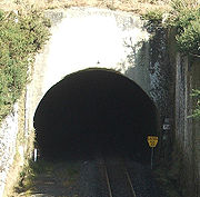
Construction of the South Island Main Trunk railway south of Dunedin that began in 1871 led to the construction of a 865 metres (2,837.9 ft) tunnel beneath Lookout Point, connecting Caversham with Green Island
. A second parallel 1407 metres (4,616.1 ft) tunnel – the first double-track tunnel in the country – was built starting in 1907, and all rail traffic moved to the new tunnel in 1910. Caversham was served by its own railway station until its closure in 1962. There has been a long-running campaign to have the older tunnel converted into a cycleway, though this scheme has never gained wholehearted council support.
By the 1870s the population of Caversham was growing rapidly, and in 1877, with the population at around 4,000, it was declared a borough. It held this status until amalgamation with Dunedin city in 1904. The borough's area included much of modern Forbury and St Clair, as well as what is usually regarded as Caversham today.
, known simply as The Caversham Project. Over the course of the last 30 years, a database has been compiled of life in early South Dunedin, focussing on the borough of Caversham. This database is unique in its size for a historical study within New Zealand or Australia, containing some 9.4 gigabyte
s of data, and has allowed for the examination and publication of details relating to the socioeconomic and demographic mix of early Dunedin.
The multidisciplinary nature of the study has resulted in information being gathered on subjects ranging from urban planning to gender studies. By using both quantitative and qualitative analyses, and by including considerable amounts of oral history, it has allowed for a vivid recreation of the society of early urban New Zealand. Several books have resulted from the project, among them Sites of Gender: Women, Men and Modernity, 1890–1939, edited by B. Brookes, A. Cooper, and R. Law (Auckland University Press, 2003) and Class and Occupation: The New Zealand Reality by E. Olssen and M. Hickey (University of Otago Press, 2005).
. The borough of Caversham, which existed until November 1904, took in a far larger area than the current suburb, including much of Saint Clair, South Dunedin, Kew, and Kensington, and stretched to the Pacific
coast in the south and Otago Harbour
in the east. The names of several of the borough's mayors are commemorated in streets within the former borough, among them Robert Rutherford, William Bridgman, and Thomas Kay Sidey.
The Dunedin City Council currently administers Caversham; the suburb is located in the city's South Dunedin ward, one of the city's six wards. This ward covers a considerable part of Dunedin's main urban area, as well as the entirety of the Otago Peninsula
. It elects four councillors to Dunedin's 14-member city council.
At a national level, Caversham was a separate electorate
from 1866 to 1908. MPs
for the electorate included Thomas Kay Sidey and future Premier
Robert Stout
. Since 1908 Caversham has been in various electorates, and is currently part of the Dunedin South
electorate. , its MP
is Clare Curran
(Labour
).
. There is little evidence of this distinction in modern Caversham, other than the origins of local street names, several of which reflect the names of English counties and early English settlers.
Caversham began largely as a lower-middle to working-class suburb. Many of the early residents were skilled or semi-skilled tradespeople. In its early days, Caversham was known as "The carpenters' borough", as a high proportion of the skilled workers within the borough were employed in the building trade. The socioeconomic mix of the borough, combined with the Protestant religious make-up of Caversham, led to strong traditions of egalitarian and social humanitarian politics in the borough.
The left-leaning politics of the area is still reflected to some extent in local political views. The Dunedin South
electorate, of which Caversham is a part, tends to return New Zealand Labour Party
Members of Parliament and support this and other left-of-centre parties. In the 2008 New Zealand general election
, 54.8% of valid party votes cast in Caversham's two polling stations were for the Labour Party and 10.4% were for the three other main left-of-centre parties (Green, Alliance
, and Progressive). The vote for these parties over the whole Dunedin South electorate was 46.7% and 9.4% respectively. The equivalent figures for New Zealand as a whole were 34.0% and 7.7% respectively.
Many residents of Caversham are still of relatively low socio-economic status when compared to those in surrounding hill suburbs. A 2007 Dunedin City Council report indicated that a high proportion (39%) of the suburb's houses were one- or two-bedroom dwellings.
Caversham's 2006 population was 5,058. The suburb has a slightly higher proportion of elderly residents than the Otago
average, with 15.8% of residents aged 65 and over. It also has a considerably higher proportion of residents of Māori and Pacific island descent than the Otago average (10.3% and 4.4% respectively). Caversham also has nearly twice the average Otago proportion of one-parent families (26.5%). Ownership of and access to home telecommunications (such as the internet) and to private motor vehicles is considerably lower than the Otago average.
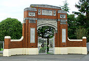 Caversham has no secondary schools, although it does contain two primary schools and a special needs school. Caversham Primary School, at the corner of South Road and Surrey Street, has been at its present site since 1921. The school dates back to the early 1860s, and has a current enrollment of around 80 pupils. The school's two-storey 1920s brick buildings were pulled down and replaced in 1961, because of their structural unsoundness. The school's main gate – the only surviving remnant of the earlier structure – is the suburb's war memorial.
College Street School, south of South Road's retail area, was built on an earlier site of Caversham Primary School. It was officially part of Caversham Primary School until 1959, when it was declared a separate institution, and now has about 250 pupils. A third school, the Sara Cohen School
in Rutherford Street, was established in 1926. This school caters for special needs pupils
from primary school age through adulthood. The school was named for the late wife of Mark Cohen, city councillor, campaigner for women's rights, and editor of the Evening Star
newspaper from 1893 to 1920. In 1889, Mark Cohen was a major figure behind the founding of New Zealand's first kindergarten.
There are kindergarten
s and child-care centres in both Rutherford Street (by Kew Park) and South Road (to the east of the main retail area), and there are numerous pre-school facilities and further primary schools in the suburbs of Forbury and Saint Clair
, immediately to the south of Caversham. The nearest secondary schools are the single-sex schools of Queen's High School
and King's High School
, located alongside each other close to the boundary between Saint Clair and South Dunedin
, 1 kilometre (0.621372736649807 mi) to the south.
 In its early years, Caversham was heavily industrialised, but also contained a large number of residential properties. The population included a large number of skilled tradespeople and craftspeople, and both large and small industries abounded. Local industries at the beginning of the twentieth century included a brickworks, a gasworks, breweries, a smithy, milliners, several bakeries, a tannery, a bootmakers, and Rutherford's Wax Vesta match factory at Forbury Corner. In 1900, the South Road-David Street-Forbury Corner area was home to over 50 businesses.
Today, the suburb is mainly residential, though it has areas of retail and light industrial businesses. The main retail area is on South Road between the start of the rise up Caversham Valley and David Street, extending into David Street and the western end of Hillside Road (Forbury Corner, sometimes referred to as Kew Corner). A few shops are also located on South Road 0.8 kilometre (0.497098189319845 mi) to the east, near Carisbrook
. Hillside Road becomes increasingly light industrial as it approaches South Dunedin, with automotive engineers
, car sales yards, joiner
ies, a rope factory, and a funeral parlour. One of Dunedin’s largest industrial sites, the Hillside Railway Workshops, dominates the eastern end of Hillside Road, close to which lie other, smaller, industrial sites. Beyond this is the shopping precinct of South Dunedin.
Caversham has four public house
s – considerably fewer than in its formative years. These are the Carisbrook Hotel, close to the sports ground for which it is named, Mitchell's Tavern in the South Road retail area, the Waterloo Hotel at Forbury Corner, and the Fitzroy Hotel on Hillside Road near Bathgate Park.
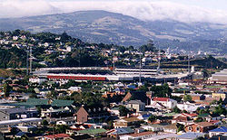 Carisbrook
, the city's main rugby union
venue and a former Test cricket
ground, is at the eastern end of the suburb between The Glen and the Hillside Railway Workshops. As of 2009, the future of Carisbrook is in doubt, with the construction of a new stadium in North Dunedin (the Forsyth Barr Stadium at University Plaza). This stadium, which is due to open in 2011, will be the new home of the Otago Rugby Union and Highlanders Super 14
franchise. The new stadium, also known as the Awatea Street Stadium, has met with some opposition within Dunedin, with objections focusing largely on the expected cost of a stadium that may find limited use.
Other than Carisbrook, the suburb's main sports ground is Bathgate Park, which lies at the border of Caversham and South Dunedin in the southeast. There are several open areas of recreation ground and parkland, notably Kew Park at Forbury Corner and Sidey Park and adjacent parkland along the northern flank of the by-pass, and there are tennis courts close to Kew Park on Thorn Street, and a croquet club between South Road and the Caversham by-pass. Kew Park is also home to one of the area's most prominent petanque
clubs.
Other sporting links with the suburb include Caversham Football Club
, one of Dunedin's most successful soccer teams. Caversham has reached the semi-finals of the national knockout competition
(the Chatham Cup
) on three occasions, and was a member of the former New Zealand National Soccer League
for several seasons in the 1970s with a highest final position of fourth in 1975. They also played in the competition's final season (2003). Despite its name, Caversham play at Tonga Park, located in the adjacent suburb of Forbury, a ground they share with the Carisbrook-Dunedin Cricket Club. Caversham is also home to one of Dunedin's main athletics clubs.
The Southern Rugby Football Club, a rugby union club, is located at Bathgate Park to the southeast of Caversham. Southern is consistently among Dunedin's stronger club sides, and has been Otago
club champion on over 20 occasions. It was formed from a merger of the Caversham and Pacific clubs in 1899. Southern's players have included over 20 All Blacks
, including Stephen Bachop
, Stu Forster
, Jamie Joseph
, Laurie Mains
, and Gary Seear
.
 Hillside Railway Workshops dominate the southeast of Caversham and the neighbouring suburb of South Dunedin. Established at this site in 1875, the workshops are the main railway construction and repair shop in the South Island. The workshops cover 8 hectares (19.8 acre), of which 3 hectares (7.4 acre) are covered floor space.
To the north of the workshops is Carisbrook
, arguably Dunedin's main sports venue. Opened in 1883, the ground has a capacity of 35,000 people, and has been floodlit since the 1990s. Carisbrook is used primarily for rugby union, but has also been used for other sports, notably as a Test cricket venue. The ground is named for the former home of early colonial settler James Macandrew
, which in turn was named for Carisbrooke Castle
on the Isle of Wight
in southern England.
Lisburn House is one of the finest surviving 1860s townhouses in New Zealand. Now run as a bed and breakfast establishment, this house was built in 1865 for the Fulton family, a pioneer farming family at their "Ravenscliffe" property on the Taieri Plains
. The house was named for the family's origins in Lisburn
, Northern Ireland
, and is Category I heritage listed
. William Clayton
designed the 12-room house, notable for its steeply angled slate roof and polychromatic brickwork. Two other Category II heritage buildings are on Fitzroy Street: Faringdon Villa, and an untitled house.
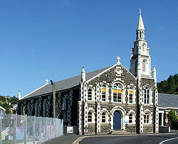
Other buildings of note in Caversham include the suburb's churches. The Presbyterian church is located on Thorn Street, roughly halfway between the South Road retail area and Forbury Corner. It was built in 1883 following the destruction of the previous building by fire. The current building, built in Port Chalmers
bluestone
with Oamaru stone
facings, was designed by T. B. Cameron.
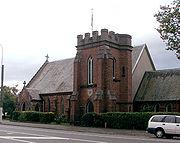
 Caversham's Anglican church, St. Peter's, is located on Hillside Road. Designed by H. F. Hardy, the foundation stone was laid in 1882. The original design called for the church to have a spire, but because of problems with the tower's foundations (which left the tower leaning 6 inches (15.2 cm) from the perpendicular) this was never constructed.
Caversham Baptist church is located at the corner of South Road and Surrey Street, close to Caversham School. Unusual among Dunedin buildings, this church has a formal Classical style, with its brickwork augmented by pediment
s and square columns. The foundation stone for the building was laid in 1906. The former Baptist Church, in Playfair Street, is now used as a Gospel Hall.
A further church, located in South Dunedin close to the southeastern edge of Caversham, is the South Dunedin Wesley Methodist Church in Hillside Road. This building, constructed in 1893, is (as of 2009) under threat of demolition.
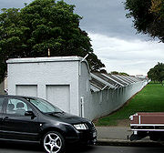
Part of the factory of Donaghy's Industries, adjacent to the eastern edge of Bathgate Park, is notable because of its unusual shape. This structure, which is less than 4 metres (13.1 ft) wide yet some 380 metres (1,246.7 ft) in length, serves as a ropewalk
for Donaghy's, who have been manufacturing rope and twine at this site since 1876.
 Noted residents in the Caversham area have included members of the Sidey family, several of whom were local or national politicians. Among these was Thomas Sidey
, New Zealand Attorney General
1928–31. Sidey Park, close to the northern edge of the Caversham bypass, and Sidey Street in Corstorphine
are both named in his honour.
Captain William Cargill
, founder of the Otago settlement, lived just to the northeast of Caversham above The Glen; his house "Hillside" gave its name to Hillside Road, which was at one time called Cargill Road. The area around the site of Cargill's long-demolished house between The Glen and Kensington is still referred to as Hillside. Cargill's Corner, the major road junction at the South Dunedin end of Hillside Road, is also named in his honour.
Architect Edmund Anscombe
was a Caversham resident. Anscombe was responsible for numerous important buildings in early 20th century New Zealand, many of which survive to the present day. Among them are the Sarjeant Art Gallery in Wanganui
and the Former Post and Telegraph Building
in Wellington
. Noted local buildings with work by Anscombe include extensions to the University of Otago Clocktower complex
in Dunedin North
, the main building of Otago Girls' High School
in central Dunedin, and the Allied Press
building in Lower Stuart Street
, Dunedin.
Another notable local resident was surveyor and architect John Turnbull Thomson
. Thomson was Chief Surveyor of the Otago Province from 1856 to 1873, and Surveyor-General of New Zealand from 1876 to 1879. During his time as provincial Chief Surveyor, Thomson explored and mapped large sections of the interior of the southern South Island. Many of the place names in this region reflect Thomson's Northumbrian
origins, with prosaic names in the form of a Northumbrian dialectic name for an animal. As a result, the area is still occasionally referred to as "Thomson's Barnyard" or "The Farmyard Patch".
Among sportspeople with Caversham connections, Australian Test cricketer and 1931 Wisden Cricketer of the year
Clarrie Grimmett
is perhaps the best known. Grimmett, the first player to take 200 Test
wickets, was born in the suburb on Christmas Day, 1891. Noted rugby union administrators "Old Vic" Cavanagh
and "Young Vic" Cavanagh
were also born in Caversham. Between them, the father and son were responsible for changes to the way the game of rugby union was played through their innovative coaching methods and tactics.
 The suburb's main road is South Road, which at its eastern (Glen) end winds around the flanks of hills before joining with Princes Street
and Dunedin's central business district
. A slip road connects South Road with State Highway 1
at the foot of these hills, just above Carisbrook.
Hillside Road, which runs parallel with South Road several hundred metres to the south, is an arterial route connecting South Dunedin
(at its eastern end) with Dunedin's southwestern suburbs. At its western end is Forbury Corner, a road junction linking Hillside Road with suburban arterial routes to the suburbs of Saint Clair
(Forbury Road) and Corstorphine
(Easther Crescent), as well as David Street, the major road link between Hillside Road and South Road. Numerous other small residential streets run parallel with David Street between Hillside Road and South Road. The suburb's other main roads include Caversham Valley Road, Playfair Street, Surrey Street, and Glen Road. The latter of these lies at the Glen at the eastern end of Caversham, providing a link between South Road and the hill suburbs of Maryhill
, Balaclava, and Mornington
.
A Caversham bypass
was constructed in the late 1970s and early 1980s, and was officially opened in 1987. It now carries State Highway 1 away from the retail heart of the suburb, connecting at its northern end with the city's one-way street system. With the construction of the bypass, Caversham Valley Road was truncated close to its junction with South Road, and the upper stretch of the road continued as part of State Highway 1, connecting the bypass with Dunedin Southern Motorway
.
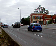
Until the construction of the bypass, South Road and Caversham Valley Road formed the main route out of Dunedin to the south. State Highway 1 followed South Road through the main retail area, then followed Caversham Valley Road to Lookout Point. Above its retail area, South Road winds around the flank of Calton Hill; Caversham Valley Road forms a straighter, steep route that originally continued from the end of South Road's retail area. For this reason, the part of South Road running through the retail area is also sometimes referred to as part of Caversham Valley Road. The Dunedin City Council, for many years, has planned improvements to Caversham Valley Road to ease congestion and increase safety on this busy stretch of road, but these plans lack the necessary funding. A junction at the north end of Caversham's main retail area connects South Road with the bypass.
Trams served Caversham between 1880 and 1954, operating in Hillside Road, South Road, and David Street. Several bus routes now serve Caversham, connecting it with the heart of the city. Citibus and Dunedin Passenger Transport
run routes from the city centre to Saint Clair and Corstorphine via Hillside Road, and to Lookout Point via South Road. Dunedin passenger transport also runs services between The Octagon
and both Mosgiel
and Brighton
via South Road. Cargill's Corner, at the South Dunedin
end of Hillside Road, is a major suburban bus hub.
South Island
The South Island is the larger of the two major islands of New Zealand, the other being the more populous North Island. It is bordered to the north by Cook Strait, to the west by the Tasman Sea, to the south and east by the Pacific Ocean...
New Zealand
New Zealand
New Zealand is an island country in the south-western Pacific Ocean comprising two main landmasses and numerous smaller islands. The country is situated some east of Australia across the Tasman Sea, and roughly south of the Pacific island nations of New Caledonia, Fiji, and Tonga...
city of Dunedin
Dunedin
Dunedin is the second-largest city in the South Island of New Zealand, and the principal city of the Otago Region. It is considered to be one of the four main urban centres of New Zealand for historic, cultural, and geographic reasons. Dunedin was the largest city by territorial land area until...
. It is sited at the western edge of the city's central plain at the mouth of the steep Caversham Valley, which rises to the saddle of Lookout Point. Major road and rail routes south lie nearby; the South Island Main Trunk railway runs through the suburb, and a bypass
Bypass (road)
A bypass is a road or highway that avoids or "bypasses" a built-up area, town, or village, to let through traffic flow without interference from local traffic, to reduce congestion in the built-up area, and to improve road safety....
skirts its main retail area, connecting Dunedin's one-way street system with the Dunedin Southern Motorway
Dunedin Southern Motorway
The Dunedin Southern Motorway is the main arterial route south from the South Island city of Dunedin, part of New Zealand's State Highway 1. It is one of the world's southernmost motorways.-Route:...
. The suburb is linked by several bus routes to its neighbouring suburbs and central Dunedin.
The suburb was founded by wealthy pioneer William Henry Valpy
William Henry Valpy
William Henry Valpy was a noted early settler of Dunedin, New Zealand. He is sometimes referred to locally as "The father of Saint Clair", as he was the first settler in the area now occupied by the suburb of Saint Clair....
, and its name reflects his family connections with the town of Reading
Reading, Berkshire
Reading is a large town and unitary authority area in England. It is located in the Thames Valley at the confluence of the River Thames and River Kennet, and on both the Great Western Main Line railway and the M4 motorway, some west of London....
, in the English
England
England is a country that is part of the United Kingdom. It shares land borders with Scotland to the north and Wales to the west; the Irish Sea is to the north west, the Celtic Sea to the south west, with the North Sea to the east and the English Channel to the south separating it from continental...
county of Berkshire
Berkshire
Berkshire is a historic county in the South of England. It is also often referred to as the Royal County of Berkshire because of the presence of the royal residence of Windsor Castle in the county; this usage, which dates to the 19th century at least, was recognised by the Queen in 1957, and...
. Caversham grew rapidly during the Central Otago Gold Rush
Central Otago Gold Rush
The Central Otago Gold Rush was a gold rush that occurred during the 1860s in Central Otago, New Zealand...
of the 1860s because of its location on routes south to the Otago
Otago
Otago is a region of New Zealand in the south of the South Island. The region covers an area of approximately making it the country's second largest region. The population of Otago is...
hinterland. By the end of the 19th century, Caversham was heavily industrialised, and its population included many skilled or semi-skilled tradespeople. This, combined with the community's strong Protestant roots, led to the area's generally left-leaning political stance. Caversham's early history has been the subject of the Caversham Project, a major historical and archaeological study by the University of Otago
University of Otago
The University of Otago in Dunedin is New Zealand's oldest university with over 22,000 students enrolled during 2010.The university has New Zealand's highest average research quality and in New Zealand is second only to the University of Auckland in the number of A rated academic researchers it...
. Caversham was a separate borough until 1904, when it was amalgamated with Dunedin city. It is currently administered as part of the city's South Dunedin ward. At a national level, it is part of the Dunedin South
Dunedin South
Dunedin South is a New Zealand Parliamentary electorate. It first existed from 1881–1890, then from 1905–1946 and was re-established for the introduction of MMP in 1996. A Labour Party stronghold, it has been represented by Clare Curran since the .-Area:...
electorate.
Caversham is now predominantly residential, with some industrial premises in the east (notably the Hillside Railway Workshops) and a retail district centred on South Road and Hillside Road. Residents are generally of low socio-economic status. Caversham's notable buildings include the heritage listed
New Zealand Historic Places Trust
The New Zealand Historic Places Trust is a non-profit trust that advocates for the protection of ancestral sites and heritage buildings in New Zealand...
Lisburn House and several prominent church buildings. Another landmark is the suburb's war memorial, which is the main gate of Caversham School, one of the suburb's two primary schools. Caversham also contains a special needs school
Special education
Special education is the education of students with special needs in a way that addresses the students' individual differences and needs. Ideally, this process involves the individually planned and systematically monitored arrangement of teaching procedures, adapted equipment and materials,...
. The nearest secondary schools are located in St Clair, 1 kilometre (0.621372736649807 mi) to the south.
Caversham has strong sporting connections, and is the location of Carisbrook
Carisbrook
Carisbrook was a major sporting venue in Dunedin, New Zealand. The city's main domestic and international rugby union venue, it has also been used for other sports such as cricket, football, rugby league and motocross. Carisbrook has also hosted a Joe Cocker concert and frequently hosted pre-game...
, one of the city's main sports venues. The suburb is home to the Southern Rugby Football Club, and gives its name to Caversham Football Club
Caversham (soccer)
Caversham is an illustrious association Football club in Dunedin, New Zealand. They are competing in the ODT FootballSouth Premier League.They are named for the suburb of Caversham to the southwest of Dunedin's city centre, best known for its former international sports venue Carisbrook...
. Several notable sportspeople have associations with Caversham, among them Test cricket
Test cricket
Test cricket is the longest form of the sport of cricket. Test matches are played between national representative teams with "Test status", as determined by the International Cricket Council , with four innings played between two teams of 11 players over a period of up to a maximum five days...
er Clarrie Grimmett
Clarrie Grimmett
Clarence Victor "Clarrie" Grimmett was a cricketer; although born in New Zealand, he played most of his cricket in Australia. He is thought by many to be one of the finest early spin bowlers, and usually credited as the developer of the flipper.Grimmett was born in Caversham a suburb of Dunedin,...
and father and son rugby union
Rugby union
Rugby union, often simply referred to as rugby, is a full contact team sport which originated in England in the early 19th century. One of the two codes of rugby football, it is based on running with the ball in hand...
administrators "Old Vic"
Vic Cavanagh (born 1874)
Victor George Cavanagh , known as "Old Vic" Cavanagh, was a New Zealand rugby union administrator. He was born in Caversham, Dunedin. He was the father of "Young Vic" Cavanagh...
and "Young Vic" Cavanagh
Vic Cavanagh (born 1909)
Victor George Cavanagh , known as "Young Vic" Cavanagh, was a New Zealand rugby union administrator. He was born in Caversham, Dunedin. He was the son of "Old Vic" Cavanagh...
. Other notable people with Caversham connections include politician Thomas Kay Sidey, architect Edmund Anscombe
Edmund Anscombe
Edmund Anscombe was one of the most important figures to shape the architectural and urban fabric of New Zealand. He was important, not only because of the prolific nature of his practice and the quality of his work, but also because of the range and the scale of his built and speculative projects...
, and surveyor John Turnbull Thomson
John Turnbull Thomson
John Turnbull Thomson was a British civil engineer and artist who played an instrumental role in the development of the early infrastructure of nineteenth century Singapore and New Zealand. -Biography:...
.
Geography
Caversham lies at the mouth and in the lower reaches of a valley in the west of DunedinDunedin
Dunedin is the second-largest city in the South Island of New Zealand, and the principal city of the Otago Region. It is considered to be one of the four main urban centres of New Zealand for historic, cultural, and geographic reasons. Dunedin was the largest city by territorial land area until...
's main urban area, 4 kilometres (2.5 mi) southwest of the city centre, and 2 kilometres (1.2 mi) north of the Pacific
Pacific Ocean
The Pacific Ocean is the largest of the Earth's oceanic divisions. It extends from the Arctic in the north to the Southern Ocean in the south, bounded by Asia and Australia in the west, and the Americas in the east.At 165.2 million square kilometres in area, this largest division of the World...
coast at St Clair
Saint Clair, New Zealand
St Clair is a leafy residential suburb of the New Zealand city of Dunedin. It is located on the Pacific Ocean coast five kilometres from the city centre on the southwesternmost part of the coastal plain which makes up the southern part of the urban area, and also climbs the slopes of Forbury Hill...
. To the south lies Calton Hill, a spur of Forbury Hill, on which the suburbs of Calton Hill, Corstorphine
Corstorphine, New Zealand
Corstorphine is a suburb of southwest Dunedin in the South Island of New Zealand. It is located on the slopes of Calton Hill - a spur of Forbury Hill - between Caversham Valley and the Pacific Ocean...
and Kew are located.
The suburbs of Balaclava and Maryhill
Maryhill, New Zealand
Maryhill is a residential suburb of the New Zealand city of Dunedin. It is located on a ridge to the southwest of the central city between the suburbs of Mornington, Kenmure, and Caversham. The smaller suburb of Balaclava lies immediately to its west. Maryhill takes its name from a district in the...
lie to the north, close to the western end of the ridge that runs along the northern edge of central Dunedin. These hills were all once part of the rim of the Dunedin volcano, the long-extinct crater of which now forms Otago Harbour
Otago Harbour
Otago Harbour is the natural harbour of Dunedin, New Zealand, consisting of a long, much-indented stretch of generally navigable water separating the Otago Peninsula from the mainland. They join at its southwest end, from the harbour mouth...
. Other suburbs nearby include Forbury, South Dunedin
South Dunedin
South Dunedin is a major inner city suburb of the New Zealand city of Dunedin. It is located, as its name suggests, to the south of the city centre, on part of a large plain known locally simply as "The Flat". The suburb is a mix of industrial, retail, and predominantly lower-quality residential...
, Kensington, and Lookout Point.
Caversham Valley has long been the major route out of the central city to the south. The suburb is located close to the start of the Dunedin Southern Motorway
Dunedin Southern Motorway
The Dunedin Southern Motorway is the main arterial route south from the South Island city of Dunedin, part of New Zealand's State Highway 1. It is one of the world's southernmost motorways.-Route:...
(part of State Highway 1
State Highway 1 (New Zealand)
State Highway 1 is the longest and most significant road in the New Zealand roading network, running the length of both main islands. It appears on road maps as SH 1 and on road signs as a white number 1 on a red shield, but it has the official designations SH 1N in the North Island, SH 1S in the...
), the main road access to central Dunedin from the south, and close to the South Island Main Trunk railway.
The railway provides the suburb's most important industry, through the Hillside Railway Workshops, which are located in the southeast of the suburb and in the adjoining suburb of South Dunedin
South Dunedin
South Dunedin is a major inner city suburb of the New Zealand city of Dunedin. It is located, as its name suggests, to the south of the city centre, on part of a large plain known locally simply as "The Flat". The suburb is a mix of industrial, retail, and predominantly lower-quality residential...
. Despite this, there are no longer any public railway stations or halts in Caversham, the last station having closed in 1962.
The hill slopes to the north of Caversham are less densely populated, and still retain some tree cover. This, along with the steepness of the land, forms a natural barrier between Caversham and the suburb of Maryhill. Only a few winding roads traverse this barrier, most notably Glen Road, at the eastern end of Caversham. At this end, the suburb draws close to the foot of the hills, and a natural valley, known locally as "The Glen", provides easier road access to the hill ridge.
To the northeast of the Glen, a hill spur including a 20 metres (65.6 ft) cliff separates Caversham from the central part of the city. Though the name is rarely used, this spur is called Montecillo Ridge, named for the mansion of early settler W.H. Reynolds. It is occasionally referred to as "Hillside", after the house of the city's founding father Captain William Cargill
William Cargill
William Walter Cargill was the founder of the Otago settlement in New Zealand, after serving as an officer in the British Army. He was a Member of Parliament and Otago's first Superintendent.-Early life:...
which was located here. This ridge overlooks "The Flat", as the plain stretching across to the Pacific coast was (and is still) locally known. South Road winds around the spur, connecting with the southern end of Princes Street
Princes Street, Dunedin
Princes Street is a major street in Dunedin, the second largest city in the South Island of New Zealand. It runs south-southwest for two kilometres from The Octagon in the city centre to the Oval sports ground, close to the city's Southern Cemetery...
. One of the city's older and more historic cemeteries, Dunedin Southern Cemetery
Dunedin Southern Cemetery
The Southern Cemetery in the New Zealand city of Dunedin was the first major cemetery to be opened in the city. The cemetery was opened in 1858, ten years after the founding of the city in an area known as "Little Paisley"...
, lies on the inner city side of this spur.
Lookout Point
Ridge
A ridge is a geological feature consisting of a chain of mountains or hills that form a continuous elevated crest for some distance. Ridges are usually termed hills or mountains as well, depending on size. There are several main types of ridges:...
and the saddle of Lookout Point. Lookout Point commands views to the southwest past the outer suburbs of Burnside
Burnside, Otago
Burnside is a mainly industrial suburb of the New Zealand city of Dunedin. It is located at the mouth of a long valley, the Kaikorai Valley, through which flows the Kaikorai Stream. This valley stretches to the northeast for . Burnside is to the southwest of the city centre, close to eastern end...
and Green Island
Green Island, New Zealand
Green Island is an island off the coast of Dunedin, New Zealand, also the name of one of the city's suburbs. The suburb is not on the sea — formerly a borough, it took its name from the Green Island bush, uncleared native forest extending from the valley where the town is centred over the hills...
to Saddle Hill
Saddle Hill, New Zealand
Saddle Hill is a prominent landmark overlooking the northeastern end of the Taieri Plains in Otago, New Zealand. Within the limits of Dunedin city, it is located 18 kilometres to the west of the city centre, between Mosgiel and Green Island, and is clearly visible from many of the city's southern...
, as well as providing a view to the east across the southern part of the central city to Otago Harbour and the Otago Peninsula
Otago Peninsula
The Otago Peninsula is a long, hilly indented finger of land that forms the easternmost part of Dunedin, New Zealand. Volcanic in origin, it forms one wall of the eroded valley that now forms Otago Harbour. The peninsula lies south-east of Otago Harbour and runs parallel to the mainland for...
.
The Māori
Maori language
Māori or te reo Māori , commonly te reo , is the language of the indigenous population of New Zealand, the Māori. It has the status of an official language in New Zealand...
name for Lookout Point is Ko Raka-a-runga-te-raki. It was the burial site of chief Rangi-Ihia, a late 18th century Kati Mamoe
Kati Mamoe
Kāti Mamoe, or Ngāti Mamoe, is an historic Māori iwi. Originally from the Heretaunga area they moved in the 16th century to the South Island which at the time was occupied by Waitaha....
chief who was largely responsible for joining the Kai Tahu and Kati Mamoe iwi
Iwi
In New Zealand society, iwi form the largest everyday social units in Māori culture. The word iwi means "'peoples' or 'nations'. In "the work of European writers which treat iwi and hapū as parts of a hierarchical structure", it has been used to mean "tribe" , or confederation of tribes,...
. He was buried here so that "his spirit might see thence his old haunts to the southward."
The most prominent building in Lookout Point is the local fire station, which also serves both Caversham and Green Island. This 1956 structure is located immediately to the north of the saddle and is a prominent landmark upon entering or leaving Dunedin. The Dunedin Southern Motorway
Dunedin Southern Motorway
The Dunedin Southern Motorway is the main arterial route south from the South Island city of Dunedin, part of New Zealand's State Highway 1. It is one of the world's southernmost motorways.-Route:...
officially begins at the Lookout Point saddle, between Calton Hill and Maryhill, and sweeps down over broken hill country past Green Island to Mosgiel
Mosgiel
Mosgiel is an urban satellite of Dunedin in Otago, New Zealand, fifteen kilometres west of the city's centre. Since the re-organisation of New Zealand local government in 1989 it has been inside the Dunedin City Council area, but was physically separate from the contiguous suburbs until...
and the Taieri Plains
Taieri Plains
The Taieri Plains are an area of fertile agricultural land to the southwest of Dunedin, in Otago, New Zealand. The plains cover an area of some 300 square kilometres, with a maximum extent of 30 kilometres....
.
Lookout Point is also the home of the former Caversham Industrial School, located to the northeast of the fire station on Mornington Road. Established in 1869, the school was later a boys' home, and is now an adult training centre
Adult education
Adult education is the practice of teaching and educating adults. Adult education takes place in the workplace, through 'extension' school or 'school of continuing education' . Other learning places include folk high schools, community colleges, and lifelong learning centers...
. Lookout Point's main streets include South Road, Caversham Valley Road, Riselaw Road, and Mornington Road.
A 3.4 hectares (8.4 acre) forest reserve is located on the upper slopes of Caversham Valley below Lookout Point. Purchased by the Dunedin City Council in 1994 with the assistance of the Royal Forest and Bird Protection Society, it is home to various native bird and invertebrate
Invertebrate
An invertebrate is an animal without a backbone. The group includes 97% of all animal species – all animals except those in the chordate subphylum Vertebrata .Invertebrates form a paraphyletic group...
species, including one species of Peripatus
Peripatus
Peripatus is a genus of Onychophora . It is an invertebrate which gives birth to live young rather than laying eggs. It is said to be a living fossil because it has been unchanged for approximately...
(velvet worm) believed to be endemic to the Dunedin area.
History
Caversham, Berkshire
Caversham is a suburb and former village in the unitary authority of Reading, England. It lies on the north bank of the River Thames, within the royal county of Berkshire, on the opposite bank from the rest of Reading...
, a suburb of Reading
Reading, Berkshire
Reading is a large town and unitary authority area in England. It is located in the Thames Valley at the confluence of the River Thames and River Kennet, and on both the Great Western Main Line railway and the M4 motorway, some west of London....
, by William Henry Valpy
William Henry Valpy
William Henry Valpy was a noted early settler of Dunedin, New Zealand. He is sometimes referred to locally as "The father of Saint Clair", as he was the first settler in the area now occupied by the suburb of Saint Clair....
, a wealthy early settler who farmed the areas around the lower slopes of Forbury Hill; his initial farm, "The Forbury", was located in what is now St Clair
Saint Clair, New Zealand
St Clair is a leafy residential suburb of the New Zealand city of Dunedin. It is located on the Pacific Ocean coast five kilometres from the city centre on the southwesternmost part of the coastal plain which makes up the southern part of the urban area, and also climbs the slopes of Forbury Hill...
, close to a street which now bears his name. A member of Valpy's family was born in the English
England
England is a country that is part of the United Kingdom. It shares land borders with Scotland to the north and Wales to the west; the Irish Sea is to the north west, the Celtic Sea to the south west, with the North Sea to the east and the English Channel to the south separating it from continental...
Caversham.
In the early days of Dunedin, it was impossible for a dray
Wagon
A wagon is a heavy four-wheeled vehicle pulled by draught animals; it was formerly often called a wain, and if low and sideless may be called a dray, trolley or float....
to reach the Caversham Valley in wet weather unless it went by a circuitous route around the hills. Valpy solved this problem by hiring men at his own expense to build a crude road from the southern end of Princes Street
Princes Street, Dunedin
Princes Street is a major street in Dunedin, the second largest city in the South Island of New Zealand. It runs south-southwest for two kilometres from The Octagon in the city centre to the Oval sports ground, close to the city's Southern Cemetery...
to his farm at Forbury. This formed the basis for later roads into the suburb. The road curved around the edge of the hills at the Glen to avoid a large swamp, the site of which is now occupied by Carisbrook
Carisbrook
Carisbrook was a major sporting venue in Dunedin, New Zealand. The city's main domestic and international rugby union venue, it has also been used for other sports such as cricket, football, rugby league and motocross. Carisbrook has also hosted a Joe Cocker concert and frequently hosted pre-game...
sports ground.
Central Otago Gold Rush
The Central Otago Gold Rush was a gold rush that occurred during the 1860s in Central Otago, New Zealand...
of 1861 led to rapid changes when thousands of people began using the road on their way to and from the gold fields. The suburb began to expand rapidly at about this time, and the first public house
Public house
A public house, informally known as a pub, is a drinking establishment fundamental to the culture of Britain, Ireland, Australia and New Zealand. There are approximately 53,500 public houses in the United Kingdom. This number has been declining every year, so that nearly half of the smaller...
, the Edinburgh Castle Hotel, was erected in 1861. By the end of the decade, Caversham had its own school, post office, drill hall
Drill hall
A drill hall is a place such as a building or a hangar where soldiers practice and perform military drill. In the United Kingdom and Commonwealth, the term was also used for the whole headquarters building of a military reserve unit, which usually incorporated such a hall...
(from the Southern District Rifles), and Anglican and Presbyterian churches. A third church, for the Baptist
Baptist
Baptists comprise a group of Christian denominations and churches that subscribe to a doctrine that baptism should be performed only for professing believers , and that it must be done by immersion...
denomination, followed in 1872.
Several charitable organisations have had properties in Caversham, including the Otago Benevolent Institution home for invalids, and an IHC New Zealand
IHC New Zealand
IHC New Zealand is a New Zealand non-governmental organization providing support and care for people of all ages with intellectual disabilities.The acronym stands for "Intellectually Handicapped Children"....
centre at Kew Park. The Royal New Zealand Foundation of the Blind
Royal New Zealand Foundation of the Blind
The Royal New Zealand Foundation of the Blind is a provider of services to blind, deafblind and vision-impaired people. It was formerly the Royal New Zealand Foundation for the Blind.-History:...
still has its Otago premises in Hillside Road.
Bypass (road)
A bypass is a road or highway that avoids or "bypasses" a built-up area, town, or village, to let through traffic flow without interference from local traffic, to reduce congestion in the built-up area, and to improve road safety....
in the 1970s and 1980s. Other noted industries in early Caversham included breweries, a tannery, and a match factory.
Construction of the South Island Main Trunk railway south of Dunedin that began in 1871 led to the construction of a 865 metres (2,837.9 ft) tunnel beneath Lookout Point, connecting Caversham with Green Island
Green Island, New Zealand
Green Island is an island off the coast of Dunedin, New Zealand, also the name of one of the city's suburbs. The suburb is not on the sea — formerly a borough, it took its name from the Green Island bush, uncleared native forest extending from the valley where the town is centred over the hills...
. A second parallel 1407 metres (4,616.1 ft) tunnel – the first double-track tunnel in the country – was built starting in 1907, and all rail traffic moved to the new tunnel in 1910. Caversham was served by its own railway station until its closure in 1962. There has been a long-running campaign to have the older tunnel converted into a cycleway, though this scheme has never gained wholehearted council support.
By the 1870s the population of Caversham was growing rapidly, and in 1877, with the population at around 4,000, it was declared a borough. It held this status until amalgamation with Dunedin city in 1904. The borough's area included much of modern Forbury and St Clair, as well as what is usually regarded as Caversham today.
Caversham Project
The early history of the suburb and surrounding parts of southern Dunedin has been the subject of a major ongoing archaeological and historical research project into early Dunedin by the University of OtagoUniversity of Otago
The University of Otago in Dunedin is New Zealand's oldest university with over 22,000 students enrolled during 2010.The university has New Zealand's highest average research quality and in New Zealand is second only to the University of Auckland in the number of A rated academic researchers it...
, known simply as The Caversham Project. Over the course of the last 30 years, a database has been compiled of life in early South Dunedin, focussing on the borough of Caversham. This database is unique in its size for a historical study within New Zealand or Australia, containing some 9.4 gigabyte
Gigabyte
The gigabyte is a multiple of the unit byte for digital information storage. The prefix giga means 109 in the International System of Units , therefore 1 gigabyte is...
s of data, and has allowed for the examination and publication of details relating to the socioeconomic and demographic mix of early Dunedin.
The multidisciplinary nature of the study has resulted in information being gathered on subjects ranging from urban planning to gender studies. By using both quantitative and qualitative analyses, and by including considerable amounts of oral history, it has allowed for a vivid recreation of the society of early urban New Zealand. Several books have resulted from the project, among them Sites of Gender: Women, Men and Modernity, 1890–1939, edited by B. Brookes, A. Cooper, and R. Law (Auckland University Press, 2003) and Class and Occupation: The New Zealand Reality by E. Olssen and M. Hickey (University of Otago Press, 2005).
Governance
In its formative days, the Caversham Road Board administered Caversham. This organisation served as a council for Caversham until May 1877, when it became a boroughBorough
A borough is an administrative division in various countries. In principle, the term borough designates a self-governing township although, in practice, official use of the term varies widely....
. The borough of Caversham, which existed until November 1904, took in a far larger area than the current suburb, including much of Saint Clair, South Dunedin, Kew, and Kensington, and stretched to the Pacific
Pacific Ocean
The Pacific Ocean is the largest of the Earth's oceanic divisions. It extends from the Arctic in the north to the Southern Ocean in the south, bounded by Asia and Australia in the west, and the Americas in the east.At 165.2 million square kilometres in area, this largest division of the World...
coast in the south and Otago Harbour
Otago Harbour
Otago Harbour is the natural harbour of Dunedin, New Zealand, consisting of a long, much-indented stretch of generally navigable water separating the Otago Peninsula from the mainland. They join at its southwest end, from the harbour mouth...
in the east. The names of several of the borough's mayors are commemorated in streets within the former borough, among them Robert Rutherford, William Bridgman, and Thomas Kay Sidey.
The Dunedin City Council currently administers Caversham; the suburb is located in the city's South Dunedin ward, one of the city's six wards. This ward covers a considerable part of Dunedin's main urban area, as well as the entirety of the Otago Peninsula
Otago Peninsula
The Otago Peninsula is a long, hilly indented finger of land that forms the easternmost part of Dunedin, New Zealand. Volcanic in origin, it forms one wall of the eroded valley that now forms Otago Harbour. The peninsula lies south-east of Otago Harbour and runs parallel to the mainland for...
. It elects four councillors to Dunedin's 14-member city council.
At a national level, Caversham was a separate electorate
Caversham (New Zealand electorate)
Caversham was a parliamentary electorate in the city of Dunedin in the Otago Region of New Zealand, from 1866 to 1908.-History:Caversham was first established in 1866 and abolished in 1890. It was recreated in 1893 and abolished again in 1908....
from 1866 to 1908. MPs
Member of Parliament
A Member of Parliament is a representative of the voters to a :parliament. In many countries with bicameral parliaments, the term applies specifically to members of the lower house, as upper houses often have a different title, such as senate, and thus also have different titles for its members,...
for the electorate included Thomas Kay Sidey and future Premier
Prime Minister of New Zealand
The Prime Minister of New Zealand is New Zealand's head of government consequent on being the leader of the party or coalition with majority support in the Parliament of New Zealand...
Robert Stout
Robert Stout
Sir Robert Stout, KCMG was the 13th Premier of New Zealand on two occasions in the late 19th century, and later Chief Justice of New Zealand. He was the only person to hold both these offices...
. Since 1908 Caversham has been in various electorates, and is currently part of the Dunedin South
Dunedin South
Dunedin South is a New Zealand Parliamentary electorate. It first existed from 1881–1890, then from 1905–1946 and was re-established for the introduction of MMP in 1996. A Labour Party stronghold, it has been represented by Clare Curran since the .-Area:...
electorate. , its MP
Member of Parliament
A Member of Parliament is a representative of the voters to a :parliament. In many countries with bicameral parliaments, the term applies specifically to members of the lower house, as upper houses often have a different title, such as senate, and thus also have different titles for its members,...
is Clare Curran
Clare Curran
Clare Elizabeth Curran is the 3rd and current member of the New Zealand Parliament for Dunedin South.-Early life and education:Curran grew up and was educated in Dunedin, she attended Moreau College where she achieved School Certificate...
(Labour
New Zealand Labour Party
The New Zealand Labour Party is a New Zealand political party. It describes itself as centre-left and socially progressive and has been one of the two primary parties of New Zealand politics since 1935....
).
Demographics
Unlike most of Dunedin, which was settled by Scots, many early settlers in Caversham were English. This led to some degree of antagonism by the councils of the city and Caversham borough in the early days of settlement; Dunedin had been settled by the Presbyterian church, whereas Caversham's population was largely Anglican, Methodist, and BaptistBaptist
Baptists comprise a group of Christian denominations and churches that subscribe to a doctrine that baptism should be performed only for professing believers , and that it must be done by immersion...
. There is little evidence of this distinction in modern Caversham, other than the origins of local street names, several of which reflect the names of English counties and early English settlers.
Caversham began largely as a lower-middle to working-class suburb. Many of the early residents were skilled or semi-skilled tradespeople. In its early days, Caversham was known as "The carpenters' borough", as a high proportion of the skilled workers within the borough were employed in the building trade. The socioeconomic mix of the borough, combined with the Protestant religious make-up of Caversham, led to strong traditions of egalitarian and social humanitarian politics in the borough.
The left-leaning politics of the area is still reflected to some extent in local political views. The Dunedin South
Dunedin South
Dunedin South is a New Zealand Parliamentary electorate. It first existed from 1881–1890, then from 1905–1946 and was re-established for the introduction of MMP in 1996. A Labour Party stronghold, it has been represented by Clare Curran since the .-Area:...
electorate, of which Caversham is a part, tends to return New Zealand Labour Party
New Zealand Labour Party
The New Zealand Labour Party is a New Zealand political party. It describes itself as centre-left and socially progressive and has been one of the two primary parties of New Zealand politics since 1935....
Members of Parliament and support this and other left-of-centre parties. In the 2008 New Zealand general election
New Zealand general election, 2008
The 2008 New Zealand general election was held on 8 November 2008 to determine the composition of the 49th New Zealand parliament. The conservative National Party, headed by its Parliamentary leader John Key, won a plurality of votes and seats, ending 9 years of government dominated by the social...
, 54.8% of valid party votes cast in Caversham's two polling stations were for the Labour Party and 10.4% were for the three other main left-of-centre parties (Green, Alliance
Alliance (New Zealand political party)
The Alliance is a left-wing political party in New Zealand. It was formed in 1991, and was influential in the 1990s, but has since declined and has no representation in parliament. It suffered a major setback after Jim Anderton, the party's leader, left the party in 2002, taking several of the...
, and Progressive). The vote for these parties over the whole Dunedin South electorate was 46.7% and 9.4% respectively. The equivalent figures for New Zealand as a whole were 34.0% and 7.7% respectively.
Many residents of Caversham are still of relatively low socio-economic status when compared to those in surrounding hill suburbs. A 2007 Dunedin City Council report indicated that a high proportion (39%) of the suburb's houses were one- or two-bedroom dwellings.
Caversham's 2006 population was 5,058. The suburb has a slightly higher proportion of elderly residents than the Otago
Otago
Otago is a region of New Zealand in the south of the South Island. The region covers an area of approximately making it the country's second largest region. The population of Otago is...
average, with 15.8% of residents aged 65 and over. It also has a considerably higher proportion of residents of Māori and Pacific island descent than the Otago average (10.3% and 4.4% respectively). Caversham also has nearly twice the average Otago proportion of one-parent families (26.5%). Ownership of and access to home telecommunications (such as the internet) and to private motor vehicles is considerably lower than the Otago average.
Education
College Street School, south of South Road's retail area, was built on an earlier site of Caversham Primary School. It was officially part of Caversham Primary School until 1959, when it was declared a separate institution, and now has about 250 pupils. A third school, the Sara Cohen School
Sara Cohen School
The Sara Cohen School in Rutherford Street, Caversham, Dunedin is a special needs school in New Zealand.The Sara Cohen School was established in 1926. This school caters for special needs pupils from primary school age through adulthood, or ages 5 to 21...
in Rutherford Street, was established in 1926. This school caters for special needs pupils
Special education
Special education is the education of students with special needs in a way that addresses the students' individual differences and needs. Ideally, this process involves the individually planned and systematically monitored arrangement of teaching procedures, adapted equipment and materials,...
from primary school age through adulthood. The school was named for the late wife of Mark Cohen, city councillor, campaigner for women's rights, and editor of the Evening Star
Evening Star (Dunedin)
The Evening Star was a daily evening newspaper published in Dunedin, New Zealand from June 1863. Second-longest lasting of Dunedin's newspapers, it was the only rival to the Otago Daily Times to survive beyond the first few years of the twentieth century.The Star - as the paper was originally...
newspaper from 1893 to 1920. In 1889, Mark Cohen was a major figure behind the founding of New Zealand's first kindergarten.
There are kindergarten
Kindergarten
A kindergarten is a preschool educational institution for children. The term was created by Friedrich Fröbel for the play and activity institute that he created in 1837 in Bad Blankenburg as a social experience for children for their transition from home to school...
s and child-care centres in both Rutherford Street (by Kew Park) and South Road (to the east of the main retail area), and there are numerous pre-school facilities and further primary schools in the suburbs of Forbury and Saint Clair
Saint Clair, New Zealand
St Clair is a leafy residential suburb of the New Zealand city of Dunedin. It is located on the Pacific Ocean coast five kilometres from the city centre on the southwesternmost part of the coastal plain which makes up the southern part of the urban area, and also climbs the slopes of Forbury Hill...
, immediately to the south of Caversham. The nearest secondary schools are the single-sex schools of Queen's High School
Queen's High School, Dunedin
Queen's High School is a state single-sex girls' secondary school in Dunedin. It is located at the southern end of the city close to the boundary between the suburbs of St. Clair and Forbury, next to the parallel single-sex boys' school, King's, with which it shares some facilities....
and King's High School
King's High School, Dunedin
King's High School is a state single-sex boys' secondary school in Dunedin, New Zealand. It is located at the southern end of the city close to the boundary between the suburbs of South Dunedin, St. Clair and Forbury, next to the parallel single-sex girls' school, Queen's High School...
, located alongside each other close to the boundary between Saint Clair and South Dunedin
South Dunedin
South Dunedin is a major inner city suburb of the New Zealand city of Dunedin. It is located, as its name suggests, to the south of the city centre, on part of a large plain known locally simply as "The Flat". The suburb is a mix of industrial, retail, and predominantly lower-quality residential...
, 1 kilometre (0.621372736649807 mi) to the south.
Economy
Today, the suburb is mainly residential, though it has areas of retail and light industrial businesses. The main retail area is on South Road between the start of the rise up Caversham Valley and David Street, extending into David Street and the western end of Hillside Road (Forbury Corner, sometimes referred to as Kew Corner). A few shops are also located on South Road 0.8 kilometre (0.497098189319845 mi) to the east, near Carisbrook
Carisbrook
Carisbrook was a major sporting venue in Dunedin, New Zealand. The city's main domestic and international rugby union venue, it has also been used for other sports such as cricket, football, rugby league and motocross. Carisbrook has also hosted a Joe Cocker concert and frequently hosted pre-game...
. Hillside Road becomes increasingly light industrial as it approaches South Dunedin, with automotive engineers
Automotive engineering
Modern automotive engineering, along with aerospace engineering and marine engineering, is a branch of vehicle engineering, incorporating elements of mechanical, electrical, electronic, software and safety engineering as applied to the design, manufacture and operation of motorcycles, automobiles,...
, car sales yards, joiner
Joiner
A joiner differs from a carpenter in that joiners cut and fit joints in wood that do not use nails. Joiners usually work in a workshop since the formation of various joints generally requires non-portable machinery. A carpenter normally works on site...
ies, a rope factory, and a funeral parlour. One of Dunedin’s largest industrial sites, the Hillside Railway Workshops, dominates the eastern end of Hillside Road, close to which lie other, smaller, industrial sites. Beyond this is the shopping precinct of South Dunedin.
Caversham has four public house
Public house
A public house, informally known as a pub, is a drinking establishment fundamental to the culture of Britain, Ireland, Australia and New Zealand. There are approximately 53,500 public houses in the United Kingdom. This number has been declining every year, so that nearly half of the smaller...
s – considerably fewer than in its formative years. These are the Carisbrook Hotel, close to the sports ground for which it is named, Mitchell's Tavern in the South Road retail area, the Waterloo Hotel at Forbury Corner, and the Fitzroy Hotel on Hillside Road near Bathgate Park.
Sport
Carisbrook
Carisbrook was a major sporting venue in Dunedin, New Zealand. The city's main domestic and international rugby union venue, it has also been used for other sports such as cricket, football, rugby league and motocross. Carisbrook has also hosted a Joe Cocker concert and frequently hosted pre-game...
, the city's main rugby union
Rugby union
Rugby union, often simply referred to as rugby, is a full contact team sport which originated in England in the early 19th century. One of the two codes of rugby football, it is based on running with the ball in hand...
venue and a former Test cricket
Test cricket
Test cricket is the longest form of the sport of cricket. Test matches are played between national representative teams with "Test status", as determined by the International Cricket Council , with four innings played between two teams of 11 players over a period of up to a maximum five days...
ground, is at the eastern end of the suburb between The Glen and the Hillside Railway Workshops. As of 2009, the future of Carisbrook is in doubt, with the construction of a new stadium in North Dunedin (the Forsyth Barr Stadium at University Plaza). This stadium, which is due to open in 2011, will be the new home of the Otago Rugby Union and Highlanders Super 14
Super 14
Super Rugby is the largest and pre-eminent professional Rugby union competition in the Southern Hemisphere...
franchise. The new stadium, also known as the Awatea Street Stadium, has met with some opposition within Dunedin, with objections focusing largely on the expected cost of a stadium that may find limited use.
Other than Carisbrook, the suburb's main sports ground is Bathgate Park, which lies at the border of Caversham and South Dunedin in the southeast. There are several open areas of recreation ground and parkland, notably Kew Park at Forbury Corner and Sidey Park and adjacent parkland along the northern flank of the by-pass, and there are tennis courts close to Kew Park on Thorn Street, and a croquet club between South Road and the Caversham by-pass. Kew Park is also home to one of the area's most prominent petanque
Pétanque
Pétanque is a form of boules where the goal is, while standing inside a starting circle with both feet on the ground, to throw hollow metal balls as close as possible to a small wooden ball called a cochonnet or jack. It is also sometimes called a bouchon or le petit...
clubs.
Other sporting links with the suburb include Caversham Football Club
Caversham (soccer)
Caversham is an illustrious association Football club in Dunedin, New Zealand. They are competing in the ODT FootballSouth Premier League.They are named for the suburb of Caversham to the southwest of Dunedin's city centre, best known for its former international sports venue Carisbrook...
, one of Dunedin's most successful soccer teams. Caversham has reached the semi-finals of the national knockout competition
Single-elimination tournament
A single-elimination tournament, also called a knockout, cup or sudden death tournament, is a type of elimination tournament where the loser of each match or bracket is immediately eliminated from winning the championship or first prize in the event...
(the Chatham Cup
Chatham Cup
The Chatham Cup, currently known as the ASB Chatham Cup for sponsorship purposes, is New Zealand's premier knockout tournament in men's football...
) on three occasions, and was a member of the former New Zealand National Soccer League
New Zealand National Soccer League
The National Soccer League is a name given to competitions in which New Zealand's top soccer clubs play each other, at least two times, on a home and away basis . At the completion of the competition, the best-performed team is declared as the New Zealand champion...
for several seasons in the 1970s with a highest final position of fourth in 1975. They also played in the competition's final season (2003). Despite its name, Caversham play at Tonga Park, located in the adjacent suburb of Forbury, a ground they share with the Carisbrook-Dunedin Cricket Club. Caversham is also home to one of Dunedin's main athletics clubs.
The Southern Rugby Football Club, a rugby union club, is located at Bathgate Park to the southeast of Caversham. Southern is consistently among Dunedin's stronger club sides, and has been Otago
Otago Rugby Football Union
The Otago Rugby Football Union is the official governing body of rugby union for the Otago Region of New Zealand. The union is based in the city of Dunedin, and its home ground is Forsyth Barr Stadium. The top representative team competes in the ITM Cup, New Zealand's top provincial...
club champion on over 20 occasions. It was formed from a merger of the Caversham and Pacific clubs in 1899. Southern's players have included over 20 All Blacks
All Blacks
The New Zealand men's national rugby union team, known as the All Blacks, represent New Zealand in what is regarded as its national sport....
, including Stephen Bachop
Stephen Bachop
Stephen Bachop is a former rugby player from New Zealand. He is the older brother of fellow All Black Graeme Bachop.-Provincial:...
, Stu Forster
Stu Forster
Stuart Thomas Forster is a former All Black half-back.-External links:...
, Jamie Joseph
Jamie Joseph
James Whitinui Joseph is a former All Black flanker.Joseph's All Blacks career spanned 30 matches including 20 tests from 1992 to 1995 including the 1995 World Cup....
, Laurie Mains
Laurie Mains
Laurence William 'Laurie' Mains MNZM is a former rugby union footballer and coach who represented New Zealand. Mains' representative career started when he first played for Otago in 1967. He made his All Blacks début in 1971, against the British and Irish Lions. His last Test was against Ireland...
, and Gary Seear
Gary Seear
Gary Alan Seear is a former All Black number eight. He now works as a commercial property sales consultant for worldwide real estate firm Colliers International in Christchurch, New Zealand.-External links:...
.
Landmarks
To the north of the workshops is Carisbrook
Carisbrook
Carisbrook was a major sporting venue in Dunedin, New Zealand. The city's main domestic and international rugby union venue, it has also been used for other sports such as cricket, football, rugby league and motocross. Carisbrook has also hosted a Joe Cocker concert and frequently hosted pre-game...
, arguably Dunedin's main sports venue. Opened in 1883, the ground has a capacity of 35,000 people, and has been floodlit since the 1990s. Carisbrook is used primarily for rugby union, but has also been used for other sports, notably as a Test cricket venue. The ground is named for the former home of early colonial settler James Macandrew
James Macandrew
James Macandrew was a New Zealand ship-owner and politician. He served as a Member of Parliament from 1853 to 1887 and as the last Superintendent of Otago Province.-Early life:...
, which in turn was named for Carisbrooke Castle
Carisbrooke Castle
Carisbrooke Castle is a historic motte-and-bailey castle located in the village of Carisbrooke, near Newport, Isle of Wight, England. Charles I was imprisoned at the castle in the months prior to his trial.-Early history:...
on the Isle of Wight
Isle of Wight
The Isle of Wight is a county and the largest island of England, located in the English Channel, on average about 2–4 miles off the south coast of the county of Hampshire, separated from the mainland by a strait called the Solent...
in southern England.
Lisburn House is one of the finest surviving 1860s townhouses in New Zealand. Now run as a bed and breakfast establishment, this house was built in 1865 for the Fulton family, a pioneer farming family at their "Ravenscliffe" property on the Taieri Plains
Taieri Plains
The Taieri Plains are an area of fertile agricultural land to the southwest of Dunedin, in Otago, New Zealand. The plains cover an area of some 300 square kilometres, with a maximum extent of 30 kilometres....
. The house was named for the family's origins in Lisburn
Lisburn
DemographicsLisburn Urban Area is within Belfast Metropolitan Urban Area and is classified as a Large Town by the . On census day there were 71,465 people living in Lisburn...
, Northern Ireland
Northern Ireland
Northern Ireland is one of the four countries of the United Kingdom. Situated in the north-east of the island of Ireland, it shares a border with the Republic of Ireland to the south and west...
, and is Category I heritage listed
New Zealand Historic Places Trust
The New Zealand Historic Places Trust is a non-profit trust that advocates for the protection of ancestral sites and heritage buildings in New Zealand...
. William Clayton
William Clayton (architect)
William Henry Clayton was a New Zealand colonial architect.-Early life:Born in Norfolk Plains, Australia, Clayton trained as an architect in England, and designed more than three hundred buildings in Tasmania before emigrating to New Zealand in 1863.-New Zealand career:He established the practice...
designed the 12-room house, notable for its steeply angled slate roof and polychromatic brickwork. Two other Category II heritage buildings are on Fitzroy Street: Faringdon Villa, and an untitled house.
Other buildings of note in Caversham include the suburb's churches. The Presbyterian church is located on Thorn Street, roughly halfway between the South Road retail area and Forbury Corner. It was built in 1883 following the destruction of the previous building by fire. The current building, built in Port Chalmers
Port Chalmers
Port Chalmers is a suburb and the main port of the city of Dunedin, New Zealand, with a population of 3,000. Port Chalmers lies ten kilometres inside Otago Harbour, some 15 kilometres northeast from Dunedin's city centre....
bluestone
Bluestone
Bluestone is a cultural or commercial name for a number of dimension or building stone varieties, including:*a feldspathic sandstone in the U.S. and Canada;*limestone in the Shenandoah Valley in the U.S...
with Oamaru stone
Oamaru stone
Oamaru stone is a hard, compact limestone, quarried at Weston, near Oamaru in Otago, New Zealand.The stone is used for building purposes, especially where ornate moulding is required. The finished stonework has a creamy, sandy colour...
facings, was designed by T. B. Cameron.
Caversham Baptist church is located at the corner of South Road and Surrey Street, close to Caversham School. Unusual among Dunedin buildings, this church has a formal Classical style, with its brickwork augmented by pediment
Pediment
A pediment is a classical architectural element consisting of the triangular section found above the horizontal structure , typically supported by columns. The gable end of the pediment is surrounded by the cornice moulding...
s and square columns. The foundation stone for the building was laid in 1906. The former Baptist Church, in Playfair Street, is now used as a Gospel Hall.
A further church, located in South Dunedin close to the southeastern edge of Caversham, is the South Dunedin Wesley Methodist Church in Hillside Road. This building, constructed in 1893, is (as of 2009) under threat of demolition.
Part of the factory of Donaghy's Industries, adjacent to the eastern edge of Bathgate Park, is notable because of its unusual shape. This structure, which is less than 4 metres (13.1 ft) wide yet some 380 metres (1,246.7 ft) in length, serves as a ropewalk
Ropewalk
A ropewalk is a long straight narrow lane, or a covered pathway, where long strands of material were laid before being twisted into rope.Ropewalks historically were harsh sweatshops, and frequently caught on fire, as hemp dust forms an explosive mixture. Rope was essential in sailing ships and the...
for Donaghy's, who have been manufacturing rope and twine at this site since 1876.
Notable people
Thomas Sidey
Sir Thomas Kay Sidey was a New Zealand politician from the Otago Region, remembered for his successful advocacy of daylight saving time.-Early life:...
, New Zealand Attorney General
Attorney-General (New Zealand)
The Attorney-General is a political office in New Zealand. It is simultaneously a ministerial position and an administrative office, and has responsibility for supervising New Zealand law and advising the government on legal matters...
1928–31. Sidey Park, close to the northern edge of the Caversham bypass, and Sidey Street in Corstorphine
Corstorphine, New Zealand
Corstorphine is a suburb of southwest Dunedin in the South Island of New Zealand. It is located on the slopes of Calton Hill - a spur of Forbury Hill - between Caversham Valley and the Pacific Ocean...
are both named in his honour.
Captain William Cargill
William Cargill
William Walter Cargill was the founder of the Otago settlement in New Zealand, after serving as an officer in the British Army. He was a Member of Parliament and Otago's first Superintendent.-Early life:...
, founder of the Otago settlement, lived just to the northeast of Caversham above The Glen; his house "Hillside" gave its name to Hillside Road, which was at one time called Cargill Road. The area around the site of Cargill's long-demolished house between The Glen and Kensington is still referred to as Hillside. Cargill's Corner, the major road junction at the South Dunedin end of Hillside Road, is also named in his honour.
Architect Edmund Anscombe
Edmund Anscombe
Edmund Anscombe was one of the most important figures to shape the architectural and urban fabric of New Zealand. He was important, not only because of the prolific nature of his practice and the quality of his work, but also because of the range and the scale of his built and speculative projects...
was a Caversham resident. Anscombe was responsible for numerous important buildings in early 20th century New Zealand, many of which survive to the present day. Among them are the Sarjeant Art Gallery in Wanganui
Wanganui
Whanganui , also spelled Wanganui, is an urban area and district on the west coast of the North Island of New Zealand. It is part of the Manawatu-Wanganui region....
and the Former Post and Telegraph Building
Former Post and Telegraph Building, Wellington
The Former Post and Telegraph Building is a building located in Wellington, New Zealand.The building, located on Herd Street, was designed by Edmund Anscombe and built in 1939. It originally had two full-size tennis courts on the roof. The courts were later demolished to make way for a sixth storey...
in Wellington
Wellington
Wellington is the capital city and third most populous urban area of New Zealand, although it is likely to have surpassed Christchurch due to the exodus following the Canterbury Earthquake. It is at the southwestern tip of the North Island, between Cook Strait and the Rimutaka Range...
. Noted local buildings with work by Anscombe include extensions to the University of Otago Clocktower complex
University of Otago Clocktower complex
The University of Otago Clocktower complex is a group of architecturally and historically significant buildings in the centre of the University of Otago campus. Founded in Dunedin, New Zealand, in 1869, the University of Otago was the expression of the province's Scottish founders' commitment to...
in Dunedin North
Dunedin North
Dunedin North, also known as North Dunedin, is a major inner suburb of the New Zealand city of Dunedin, located to the northeast of the city centre. It contains many of the city's major institutions, including the city's university, polytechnic, main hospital, and largest museum...
, the main building of Otago Girls' High School
Otago Girls' High School
Otago Girls' High School is a secondary school in Dunedin, Otago, New Zealand. It was opened 6 February 1871, after a long campaign by educationalist Learmonth Whyte Dalrymple...
in central Dunedin, and the Allied Press
Allied Press
Allied Press is a New Zealand publishing company based in Dunedin. The company's main asset is the Otago Daily Times, New Zealand's oldest daily newspaper...
building in Lower Stuart Street
Stuart Street, Dunedin
Stuart Street is one of the main streets of Dunedin, New Zealand. As with many of Dunedin's streets, it is named after a main street in Edinburgh, Scotland....
, Dunedin.
Another notable local resident was surveyor and architect John Turnbull Thomson
John Turnbull Thomson
John Turnbull Thomson was a British civil engineer and artist who played an instrumental role in the development of the early infrastructure of nineteenth century Singapore and New Zealand. -Biography:...
. Thomson was Chief Surveyor of the Otago Province from 1856 to 1873, and Surveyor-General of New Zealand from 1876 to 1879. During his time as provincial Chief Surveyor, Thomson explored and mapped large sections of the interior of the southern South Island. Many of the place names in this region reflect Thomson's Northumbrian
Northumberland
Northumberland is the northernmost ceremonial county and a unitary district in North East England. For Eurostat purposes Northumberland is a NUTS 3 region and is one of three boroughs or unitary districts that comprise the "Northumberland and Tyne and Wear" NUTS 2 region...
origins, with prosaic names in the form of a Northumbrian dialectic name for an animal. As a result, the area is still occasionally referred to as "Thomson's Barnyard" or "The Farmyard Patch".
Among sportspeople with Caversham connections, Australian Test cricketer and 1931 Wisden Cricketer of the year
Wisden Cricketers of the Year
The Wisden Cricketers of the Year are cricketers selected for the honour by the annual publication Wisden Cricketers' Almanack, based primarily on their "influence on the previous English season"...
Clarrie Grimmett
Clarrie Grimmett
Clarence Victor "Clarrie" Grimmett was a cricketer; although born in New Zealand, he played most of his cricket in Australia. He is thought by many to be one of the finest early spin bowlers, and usually credited as the developer of the flipper.Grimmett was born in Caversham a suburb of Dunedin,...
is perhaps the best known. Grimmett, the first player to take 200 Test
Test cricket
Test cricket is the longest form of the sport of cricket. Test matches are played between national representative teams with "Test status", as determined by the International Cricket Council , with four innings played between two teams of 11 players over a period of up to a maximum five days...
wickets, was born in the suburb on Christmas Day, 1891. Noted rugby union administrators "Old Vic" Cavanagh
Vic Cavanagh (born 1874)
Victor George Cavanagh , known as "Old Vic" Cavanagh, was a New Zealand rugby union administrator. He was born in Caversham, Dunedin. He was the father of "Young Vic" Cavanagh...
and "Young Vic" Cavanagh
Vic Cavanagh (born 1909)
Victor George Cavanagh , known as "Young Vic" Cavanagh, was a New Zealand rugby union administrator. He was born in Caversham, Dunedin. He was the son of "Old Vic" Cavanagh...
were also born in Caversham. Between them, the father and son were responsible for changes to the way the game of rugby union was played through their innovative coaching methods and tactics.
Transportation
Princes Street, Dunedin
Princes Street is a major street in Dunedin, the second largest city in the South Island of New Zealand. It runs south-southwest for two kilometres from The Octagon in the city centre to the Oval sports ground, close to the city's Southern Cemetery...
and Dunedin's central business district
Central business district
A central business district is the commercial and often geographic heart of a city. In North America this part of a city is commonly referred to as "downtown" or "city center"...
. A slip road connects South Road with State Highway 1
State Highway 1 (New Zealand)
State Highway 1 is the longest and most significant road in the New Zealand roading network, running the length of both main islands. It appears on road maps as SH 1 and on road signs as a white number 1 on a red shield, but it has the official designations SH 1N in the North Island, SH 1S in the...
at the foot of these hills, just above Carisbrook.
Hillside Road, which runs parallel with South Road several hundred metres to the south, is an arterial route connecting South Dunedin
South Dunedin
South Dunedin is a major inner city suburb of the New Zealand city of Dunedin. It is located, as its name suggests, to the south of the city centre, on part of a large plain known locally simply as "The Flat". The suburb is a mix of industrial, retail, and predominantly lower-quality residential...
(at its eastern end) with Dunedin's southwestern suburbs. At its western end is Forbury Corner, a road junction linking Hillside Road with suburban arterial routes to the suburbs of Saint Clair
Saint Clair, New Zealand
St Clair is a leafy residential suburb of the New Zealand city of Dunedin. It is located on the Pacific Ocean coast five kilometres from the city centre on the southwesternmost part of the coastal plain which makes up the southern part of the urban area, and also climbs the slopes of Forbury Hill...
(Forbury Road) and Corstorphine
Corstorphine, New Zealand
Corstorphine is a suburb of southwest Dunedin in the South Island of New Zealand. It is located on the slopes of Calton Hill - a spur of Forbury Hill - between Caversham Valley and the Pacific Ocean...
(Easther Crescent), as well as David Street, the major road link between Hillside Road and South Road. Numerous other small residential streets run parallel with David Street between Hillside Road and South Road. The suburb's other main roads include Caversham Valley Road, Playfair Street, Surrey Street, and Glen Road. The latter of these lies at the Glen at the eastern end of Caversham, providing a link between South Road and the hill suburbs of Maryhill
Maryhill, New Zealand
Maryhill is a residential suburb of the New Zealand city of Dunedin. It is located on a ridge to the southwest of the central city between the suburbs of Mornington, Kenmure, and Caversham. The smaller suburb of Balaclava lies immediately to its west. Maryhill takes its name from a district in the...
, Balaclava, and Mornington
Mornington, Otago
Mornington is a suburb of the city of Dunedin, in the South Island of New Zealand. It is situated on hilly slopes to the west of the city centre, the slopes forming part of a ridge which surrounds the heart of the city....
.
A Caversham bypass
Bypass (road)
A bypass is a road or highway that avoids or "bypasses" a built-up area, town, or village, to let through traffic flow without interference from local traffic, to reduce congestion in the built-up area, and to improve road safety....
was constructed in the late 1970s and early 1980s, and was officially opened in 1987. It now carries State Highway 1 away from the retail heart of the suburb, connecting at its northern end with the city's one-way street system. With the construction of the bypass, Caversham Valley Road was truncated close to its junction with South Road, and the upper stretch of the road continued as part of State Highway 1, connecting the bypass with Dunedin Southern Motorway
Dunedin Southern Motorway
The Dunedin Southern Motorway is the main arterial route south from the South Island city of Dunedin, part of New Zealand's State Highway 1. It is one of the world's southernmost motorways.-Route:...
.
Until the construction of the bypass, South Road and Caversham Valley Road formed the main route out of Dunedin to the south. State Highway 1 followed South Road through the main retail area, then followed Caversham Valley Road to Lookout Point. Above its retail area, South Road winds around the flank of Calton Hill; Caversham Valley Road forms a straighter, steep route that originally continued from the end of South Road's retail area. For this reason, the part of South Road running through the retail area is also sometimes referred to as part of Caversham Valley Road. The Dunedin City Council, for many years, has planned improvements to Caversham Valley Road to ease congestion and increase safety on this busy stretch of road, but these plans lack the necessary funding. A junction at the north end of Caversham's main retail area connects South Road with the bypass.
Trams served Caversham between 1880 and 1954, operating in Hillside Road, South Road, and David Street. Several bus routes now serve Caversham, connecting it with the heart of the city. Citibus and Dunedin Passenger Transport
Passenger Transport (New Zealand)
Invercargill Passenger Transport Ltd is a bus company which operates public transport routes and school transport services in Dunedin and Invercargill and leisure and tourism transport services throughout New Zealand.-Public transport services:Passenger Transport operates almost all public...
run routes from the city centre to Saint Clair and Corstorphine via Hillside Road, and to Lookout Point via South Road. Dunedin passenger transport also runs services between The Octagon
The Octagon, Dunedin
The Octagon is the city centre of Dunedin, in the South Island of New Zealand.-Features:The Octagon is an eight sided plaza bisected by the city's main street, which is called George Street to the northeast and Princes Street to the southwest...
and both Mosgiel
Mosgiel
Mosgiel is an urban satellite of Dunedin in Otago, New Zealand, fifteen kilometres west of the city's centre. Since the re-organisation of New Zealand local government in 1989 it has been inside the Dunedin City Council area, but was physically separate from the contiguous suburbs until...
and Brighton
Brighton, New Zealand
"Ocean View, New Zealand" redirects here. For the inner Dunedin suburb occasionally referred to as Ocean View, see Andersons BayBrighton is a small seaside town within the city limits of Dunedin, in New Zealand's South Island. It is located 20 kilometres southwest from the city centre on the...
via South Road. Cargill's Corner, at the South Dunedin
South Dunedin
South Dunedin is a major inner city suburb of the New Zealand city of Dunedin. It is located, as its name suggests, to the south of the city centre, on part of a large plain known locally simply as "The Flat". The suburb is a mix of industrial, retail, and predominantly lower-quality residential...
end of Hillside Road, is a major suburban bus hub.
Works cited
- Bishop, D. G., and Turnbull, I. M. (compilers) (1996). Geology of the Dunedin Area. Lower Hutt, NZ: Institute of Geological & Nuclear Sciences. ISBN 0-478-09521-X.
- Brosnahan, Seán G., and Read, Peter J. (2002). The Birth of Modern Times: Dunedin's Southern Suburbs, 1890–1940. Dunedin: Otago Settlers' Museum. ISBN 0-908910-28-2.
- Chester, Rod; Palenski, Ron; and McMillan, Neville, (1998). The Encyclopedia of New Zealand Rugby. Auckland: Hodder Moa Beckett. ISBN 1-86958-630-1.
- Croot, Charles (1999). Dunedin Churches Past and Present. Dunedin: Otago Settlers Association. ISBN 0-473-03979-6.
- Dann, Christine, and Peat, NevilleNeville PeatNeville Peat is a Dunedin-born New Zealand author and photographer, based at Broad Bay on the Otago Peninsula. He specialises in topics about natural history, notably that of southern New Zealand and New Zealand's sub-antarctic islands...
, (1989). Dunedin, North and South Otago. Wellington: GP Books. ISBN 0-477-01438-0. - Galer, Lois (1981). Houses and Homes. Dunedin: Allied Press.
- Goodall, Maarire, and Griffiths, George J., (1980). Maori Dunedin. Dunedin: Otago Heritage Books. ISBN 0-908774-45-1.
- Knight, HardwickeHardwicke KnightFrederick Hardwicke Knight was a prominent author and photographer from Broad Bay, New Zealand...
, and Wales, Niel, (1988). Buildings of Dunedin. Dunedin: John McIndoe. ISBN 0-86868-106-7. - Hayward, Paul (1999). Even More Intriguing Dunedin Street Walks. Dunedin: Express Office Services.
- Hayward, Paul (1998). Intriguing Dunedin Street Walks. Dunedin: Express Office Services.
- Herd, Joyce, and Griffiths, George J., (1980). Discovering Dunedin. Dunedin: John McIndoe. ISBN 0-86868-030-3.
- Olssen, Erik (1995). Building the New World: Work, Politics and Society in Caversham, 1880s-1920s. Auckland: Auckland University Press. ISBN 1-86940-106-9.
- Reed, Alexander Wyclif (1975). Place Names of New Zealand. Wellington: A.H. & A.W. Reed. ISBN 0-589-00933-8.
- Rutherford, Alma (1978). The Edge of the Town. Dunedin: New Zealand Historic Places Trust (Otago Regional Committee). ISBN 0-908565-60-7.
- Sorrell, Paul (ed.) (1999). "Caversham" and "Lookout Point" in The Cyclopedia of Otago and Southland, volume 1. Dunedin: Dunedin City Council. ISBN 0-9597722-9-4.