

Dunedin North
Encyclopedia

New Zealand
New Zealand is an island country in the south-western Pacific Ocean comprising two main landmasses and numerous smaller islands. The country is situated some east of Australia across the Tasman Sea, and roughly south of the Pacific island nations of New Caledonia, Fiji, and Tonga...
city of Dunedin
Dunedin
Dunedin is the second-largest city in the South Island of New Zealand, and the principal city of the Otago Region. It is considered to be one of the four main urban centres of New Zealand for historic, cultural, and geographic reasons. Dunedin was the largest city by territorial land area until...
, located 1.5 kilometre (0.93205910497471 mi) to the northeast of the city centre. It contains many of the city's major institutions, including the city's university, polytechnic, main hospital, and largest museum. Dunedin North's 2001 population, including the University area, was 7,047.
Dunedin North is located immediately to the north and northeast of the city's CBD
Central business district
A central business district is the commercial and often geographic heart of a city. In North America this part of a city is commonly referred to as "downtown" or "city center"...
. The suburb of Woodhaugh lies immediately to the northwest, and Dalmore and the Gardens Corner lie to the north. It is centred on a widening of the inner city plain around the lower reaches of the Water of Leith
Water of Leith, New Zealand
The Water of Leith , is a small river in the South Island of New Zealand.It rises to the north of the city of Dunedin, flowing for 14 kilometres southeast through the northern part of the city and the campus of the University of Otago before reaching the Otago Harbour...
, and on land reclaimed from the Otago Harbour
Otago Harbour
Otago Harbour is the natural harbour of Dunedin, New Zealand, consisting of a long, much-indented stretch of generally navigable water separating the Otago Peninsula from the mainland. They join at its southwest end, from the harbour mouth...
, including the former Pelichet Bay. The suburb is not entirely flat, however; a spur of Signal Hill
Signal Hill, New Zealand
Signal Hill is a prominent landform in the city of Dunedin, New Zealand. It is located close to, and due north of, the head of the Otago Harbour and reaches an elevation of 393 m . The suburbs Ravensbourne, St. Leonards, and Opoho lie on its southern, eastern, and northwestern flanks, respectively...
extends across the plain to the south of the Dunedin Botanic Gardens
Dunedin Botanic Gardens
The Dunedin Botanical Gardens are located at the northern end of central Dunedin, in the South Island of New Zealand. They are located close to the University of Otago and one of the city's most historic cemeteries, the Northern Cemetery, on a spur of Signal Hill and on the river plain immediately...
, rising into the small peak of Tani Hill immediately to the northeast of the University of Otago
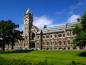
University of Otago
The University of Otago in Dunedin is New Zealand's oldest university with over 22,000 students enrolled during 2010.The university has New Zealand's highest average research quality and in New Zealand is second only to the University of Auckland in the number of A rated academic researchers it...
. The hill's name, not officially recognised and nowadays rarely used, is a corruption of "Botanic Hill", and dates from the time when the Dunedin Botanic Gardens were located on the site now occupied by the university. Two university halls of residence, Arana College
Arana College
Arana College is a residential college of the University of Otago, founded in 1943 by the Rev. William Turner and the Stuart Residence Halls Council. The name "Arana" is a Māori transliteration of "Allen", chosen to honour Sir James Allen, a former Vice Chancellor and Chancellor of the University...
and Studholme College, sit close to the peak of Tani Hill.
Dunedin North's main streets include George Street
George Street, Dunedin
George Street is the main street of Dunedin, the second largest city in the South Island of New Zealand. It runs for two and a half kilometres north-northeast from The Octagon in the city centre to the foot of Pine Hill. It is straight and undulates gently as it skirts the edge of the hills to its...
, Castle Street
Castle Street, Dunedin
Castle Street is a major street in the city of Dunedin, New Zealand. The street runs in a north-north-east direction from Stuart Street outside Dunedin Railway Station to the southern end of the Dunedin Botanical Gardens, and is bisected into two distinct parts by the University of Otago campus.The...
, Cumberland Street, Great King Street, and Anzac Avenue. These latter four roads form part of New Zealand's State Highway network, with Castle, Cumberland, and Great King Streets all being part of State Highway 1 (as well as being part of the city's one-way street system), and Anzac Avenue being part of State Highway 88
New Zealand State Highway 88
State Highway 88 is a New Zealand State Highway connecting the city centre of Dunedin with Port Chalmers, which is the location of Dunedin's main port facilities and home of one of New Zealand's major container terminals. It is roughly 18 km long....
between Dunedin and Port Chalmers
Port Chalmers
Port Chalmers is a suburb and the main port of the city of Dunedin, New Zealand, with a population of 3,000. Port Chalmers lies ten kilometres inside Otago Harbour, some 15 kilometres northeast from Dunedin's city centre....
. The first four of these streets run parallel to each other, and all five are connected by numerous cross streets such as Albany Street, Dundas Street, and Frederick Street in a grid pattern interrupted by the campus of the University of Otago
University of Otago
The University of Otago in Dunedin is New Zealand's oldest university with over 22,000 students enrolled during 2010.The university has New Zealand's highest average research quality and in New Zealand is second only to the University of Auckland in the number of A rated academic researchers it...
.
The University is the most notable feature of Dunedin North, covering 25 hectares (61.8 acre) of the suburb. Its central campus is roughly bounded by Cumberland Street, Albany Street, St. David's Street, and Clyde Street. Immediately to its east lies the Otago Polytechnic
Otago Polytechnic
The Otago Polytechnic is a public New Zealand tertiary education institute, centred in Dunedin with campuses throughout the region of Otago including Cromwell, Wanaka and Queenstown....
, and beyond this the University of Otago College of Education. Between this and the mouth of the Leith is an area of former industrial and warehousing land which is the site of the new Forsyth Barr Stadium at University Plaza, under construction.
Immediately to the north of the College of Education is a wide expanse of open parkland, Logan Park
Logan Park, Dunedin
Logan Park is a sporting venue in the city of Dunedin, New Zealand. It lies on land reclaimed from the former Lake Logan.- History :Lake Logan was reclaimed in the early 20th century...
. This contains some of the city's main sports grounds, notably the Caledonian Ground
Caledonian Ground
The Caledonian Ground, often simply known as "The Caley", is a major sports venue in the New Zealand city of Dunedin. It is primarily used for soccer and athletics, and has a capacity of 7,500.-Location:...
and the University Oval, the latter being a Test cricket
Test cricket
Test cricket is the longest form of the sport of cricket. Test matches are played between national representative teams with "Test status", as determined by the International Cricket Council , with four innings played between two teams of 11 players over a period of up to a maximum five days...
venue. Logan Park High School
Logan Park High School
Logan Park High School is a high school in Dunedin, New Zealand. It was opened in 1975 on the site of a former rifle range in a small wooded valley adjacent to Logan Park, an area of land reclaimed from the former Lake Logan and now largely converted into a park and playing fields in Dunedin North...
, one of the city's larger high schools, is located close to the Caledonian Ground in the northeast corner of the park. The small Opoho Creek flows along the edge of Logan Park before its confluence with the Leith close to the latter's mouth. The mouth of the Leith is also the location of the Otago Yacht Club. At the eastern edge of Logan Park is the Logan Point quarry, which State Highway 88 skirts the edge of between Dunedin North and the neighbouring suburb of Ravensbourne
Ravensbourne, New Zealand
Ravensbourne is a suburb of the New Zealand city of Dunedin. It is located on the steep southeastern slopes of Signal Hill above the Otago Harbour. It lies on the harbour's northern shore, east-northeast of the city centre...
.
Beyond the institutional heart of the suburb, Dunedin North is primarily residential, with much of the area occupied by student flats. As such, Dunedin North and the neighbouring suburbs of The Gardens and North East Valley
North East Valley
North East Valley is a suburb of the New Zealand city of Dunedin.-Geography and demographics:...
are often considered New Zealand's principal student ghetto
Student ghetto
A student quarter or a student ghetto is a residential area, usually in proximity to a college or university, that houses mostly students. Due to the youth and relative low income of the students, most of the housing is rented, with some cooperatives. Landlords have little incentive to properly...
. There is little in the way of industrial property within the suburb, although there is some light industry in the southeast close to Anzac Avenue, and Gregg's
Gregg's (New Zealand)
Gregg's is a New Zealand food and beverage company, best known for their coffee, desserts, and condiments. Operating since 1861, it is one of New Zealand's oldest food companies. The company is now run as part of Cerebos Greggs Ltd and was New Zealand's second largest coffee seller in 2007, after...
coffee factory is located close to Otago Polytechnic.
Other notable features of Dunedin North include Otago Museum
Otago museum
The Otago Museum is situated in Dunedin, New Zealand. It was founded in 1868 and has a collection of over two million artefacts and specimens from the fields of natural history and ethnography...
, located immediately to the east of the University, and Dunedin Public Hospital
Dunedin Public Hospital
Dunedin Hospital is the main public hospital in Dunedin, New Zealand. It is the largest hospital south of Christchurch and serves as the major hospital for the Otago and Southland regions...
, which lies at the southern edge of Dunedin North surrounded by university buildings which are part of the Otago Medical School. One of the city's most architecturally important churches, Knox Church
Knox Church, Dunedin
Knox Church is a notable building in Dunedin, New Zealand. It houses the city's second Presbyterian congregation and is the city's largest church of any denomination. Situated close to the university at the northern end of the CBD on George Street it is visible from much of the central city.It was...
, sits to the west of the hospital at the point where North Dunedin joins the CBD. In the north of the suburb lie the Dunedin Botanic Gardens
Dunedin Botanic Gardens
The Dunedin Botanical Gardens are located at the northern end of central Dunedin, in the South Island of New Zealand. They are located close to the University of Otago and one of the city's most historic cemeteries, the Northern Cemetery, on a spur of Signal Hill and on the river plain immediately...
, and above them one of the city's most historic cemeteries, the Northern Cemetery
Dunedin Northern Cemetery
The Dunedin Northern Cemetery is a major historic cemetery in the southern New Zealand city of Dunedin. It is located close to Lovelock Avenue on a spur of Signal Hill close to the Dunedin Botanic Gardens and the suburb of Opoho, overlooking Dunedin North and Logan Park. The site was set aside in...
.