

South Dunedin
Encyclopedia
South Dunedin is a major inner city suburb of the New Zealand
city of Dunedin
. It is located, as its name suggests, 2.5 kilometres (1.6 mi) to the south of the city centre, on part of a large plain known locally simply as "The Flat". The suburb is a mix of industrial, retail, and predominantly lower-quality residential properties. South Dunedin's 2001 population was 2,538.
The term South Dunedin is often used in a more general sense to refer to any or all of the various suburbs occupying The Flat, including St. Kilda
, Forbury, Kensington, Musselburgh
, and Tahuna.
. This reclaimed area, which lies immediately to the west of the harbour's head, is known as the Southern Endowment, and covers an area of close to 100 hectares (247.1 acre).
Most of the area of the southern endowment is industrial and storage, though it does contain a small park close to the wharf area and the major sports complex of The Edgar Centre
close to its southern edge.
provincial founder Captain William Cargill
(Hillside Road - at one time called Cargill Road - is named for his house, "Hillside", which lay some 0.5 kilometre (0.310686368324903 mi) to the north). At this junction, two main suburban arterial routes - King Edward Street and Hillside Road - cross. A small shopping mall, South City, is located at Cargill's Corner.
Cargill's Corner had, for many years, Dunedin's only "Barnes Dance" pedestrian crossing. Its use was phased out during the 1980s.
King Edward Street is aligned roughly north-south, linking with the southern end of Princes Street
and the centre city in the north with the densely populated coastal suburb of Saint Kilda
. Hillside Road links Andersons Bay Road - a further major suburban arterial - in the east with the suburbs of Caversham
, Corstorphine
and Saint Clair
in the west and southwest.
 Smaller, older shops stretch south along King Edward Street and west along Hillside Road from Cargill's Corner. To the east, along Hillside Road and Anderson's Bay Road are larger supermarkets and wholesalers, notably Pak'n Save
, The Warehouse, and Mitre 10 Mega
. Further along Anderson's Bay Road to the south and to the west on Hillside Road are numerous car sale yards and light industrial works. These extend into Caversham in the west, and across the reclaimed land which lies between Andersons Bay Road and Portsmouth Drive in the south and east. At its southern extreme, King Edward Street becomes increasingly residential, though there are also light industrial premises here.
Andersons Bay Road lies roughly parallel with King Edward Street some 0.5 kilometre (0.310686368324903 mi) to the east. This route, which roughly follows the original shoreline, connects with State Highway 1
and Dunedin's one-way street system in the north, and with the suburb of Musselburgh
in the south. It also provides a major route from the centre city with Otago Peninsula
.
Portsmouth Drive, a further arterial route, lies a further 0.6 kilometre (0.372823641989884 mi) to the east. This route links the centre city with Portobello Road, the long, twisting route which travels the length of Otago Peninsula's harbour coast. It is named for Dunedin's American
sister city of Portsmouth, Virginia
.
Other important roads in South Dunedin include Timaru Street on the Southern Endowment, and several streets which cross or meet King Edward Street, linking it with Anderson's Bay Road in the east or the suburbs of Saint Clair and Forbury in the west. these include Macandrew Road, Melbourne Street, McBride Street, and Bay View Road, the latter of which forms the boundary between South Dunedin and Saint Kilda.
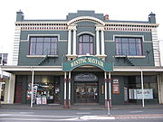 The industrial heart of South Dunedin is the Hillside Railway Workshops, located immediately to the west of Cargills Corner. These workshops cover some 8 hectares (19.8 acre) and stretch into the neighbouring suburb of Caversham. Other notable buildings in South Dunedin include the Mayfair Theatre
, close to Cargill's Corner, and the Edgar Sports Centre, at the southeastern extremity of the suburb on Portsmouth Drive. The city's main sports complex, Carisbrook
, is located close to the border of South Dunedin in Caversham. A former stadium, the Caledonian Ground
, stood on ground now largely occupied by The Warehouse retail store. It was relocated in 2000 to Logan Park
in Dunedin North
. The junction of Andersons Bay Road and Hillside Road, located nearby, is still sometimes referred to as "Caledonian Corner".
This corner is also the former site of the country's longest-serving gasworks
, which operated from 1863 to 1987, and a small industrial museum, the Dunedin Gasworks Museum, is located on the southern part of its site on Braemar Street. Opened to the public in 2001, this museum is one of only three known preserved gasworks museums in the world. The museum features five steam pumping engines which were used in the gasworks, and an older engine imported from Scotland in 1868.
There are several notable churches in South Dunedin, among them the city's only Eastern Orthodox church, St. Michael's, in Fingall Street, and St. Patrick's Roman Catholic Basilica (designed by Francis Petre
) in Macandrew Road.
megastore.
Another former landmark in south Dunedin was the former Caledonian sports ground
. This was located opposite the gasworks at the corner of Hillside Road and Andersons Bay Road, a site still known as The Caledonian Corner. The sports field was relocated to Dunedin North
, and the site is now the car park of The Warehouse - all that remains of the original sports complex is a lawn bowls club and the gymnasium, which is also South Dunedin's main war memorial (Hillside workshops have their own separate memorial by the site's main gate).
sits on the slope of Montecillo Ridge immediately above Kensington, separated from it by South Road, a main route to Caversham, which joins with Princes Street close to the Oval. These two green areas mark the southernmost extreme of Dunedin's Town Belt
, which sweeps around the central city in a broad crescent through the suburbs of Mornington
, Belleknowes, Roslyn
, Maori Hill
, Woodhaugh, and Dunedin North
.
The lower slopes of Montecillo Ridge were at one time the site of "Hillside", the home of Dunedin city's founding father Captain William Cargill
. Though the house is long gone, its name lives on in that of South Dunedin's Hillside Road.
Kensington is largely separated from South Dunedin by an overbridge carrying the South Island Main Trunk railway. The long-closed Kensington railway halt was located immediately to the east of the bridge, and accessed by a flight of stairs in one of the bridge's supports, long since sealed up. A newer flyover
200 metres to the north carries State Highway 1
through Kensington, though there are no slip roads connecting the suburb with the highway. This flyover separates Kensington into two distinct parts, a light industrial zone to the south of the flyover, and a residential zone to the north, at the foot of the ridge.
A notable feature of Kensington is the city's army drill hall
, located in Bridgman Street immediately to the south of State Highway 1.
New Zealand
New Zealand is an island country in the south-western Pacific Ocean comprising two main landmasses and numerous smaller islands. The country is situated some east of Australia across the Tasman Sea, and roughly south of the Pacific island nations of New Caledonia, Fiji, and Tonga...
city of Dunedin
Dunedin
Dunedin is the second-largest city in the South Island of New Zealand, and the principal city of the Otago Region. It is considered to be one of the four main urban centres of New Zealand for historic, cultural, and geographic reasons. Dunedin was the largest city by territorial land area until...
. It is located, as its name suggests, 2.5 kilometres (1.6 mi) to the south of the city centre, on part of a large plain known locally simply as "The Flat". The suburb is a mix of industrial, retail, and predominantly lower-quality residential properties. South Dunedin's 2001 population was 2,538.
The term South Dunedin is often used in a more general sense to refer to any or all of the various suburbs occupying The Flat, including St. Kilda
Saint Kilda, New Zealand
St Kilda is a suburb of the New Zealand city of Dunedin. A densely populated residential suburb, it lies on the southern part of the city's central plain, to the southwest of the head of the harbour and immediately north of Ocean Beach, parts of which are within the suburb and form its major...
, Forbury, Kensington, Musselburgh
Musselburgh, New Zealand
Musselburgh is a residential suburb of the New Zealand city of Dunedin. It is located in the southeast of the city's urban area, southeast of the city's centre, and at the narrowest point of the isthmus which joins Otago Peninsula to the rest of the South Island . The suburb takes its name from...
, and Tahuna.
Geography
South Dunedin is a wide area of flat land, much of it reclaimed from the Otago HarbourOtago Harbour
Otago Harbour is the natural harbour of Dunedin, New Zealand, consisting of a long, much-indented stretch of generally navigable water separating the Otago Peninsula from the mainland. They join at its southwest end, from the harbour mouth...
. This reclaimed area, which lies immediately to the west of the harbour's head, is known as the Southern Endowment, and covers an area of close to 100 hectares (247.1 acre).
Southern Endowment
The Southern Endowment was begun with rock removed during the cutting of Bell Hill in the central city during the nineteenth century. This largely extended the area around the wharves close to the heart of the city, but did not extend any further south until 1912, when a causeway was built along the head of the harbour. As part of a Otago Harbour Board scheme to reclaim land for industrial use, dredges started to pump tailings into the area behind the causeway in the 1940s. Reclamation continued for many years, and was not officially completed until the opening of Portsmouth Drive, which runs along the route of the 1912 causeway at the harbour edge, in 1978.Most of the area of the southern endowment is industrial and storage, though it does contain a small park close to the wharf area and the major sports complex of The Edgar Centre
The Edgar Centre
The Edgar Centre is a large multi-purpose indoor sports venue in South Dunedin, New Zealand, on the shore of Otago Harbour close to Andersons Bay Inlet. It is the home venue of the Otago Nuggets basketball team, and an alternate venue for the Southern Steel netball team...
close to its southern edge.
Cargill's Corner
South Dunedin contains the city's second most important retail district, centred on Cargill's Corner, named for OtagoOtago
Otago is a region of New Zealand in the south of the South Island. The region covers an area of approximately making it the country's second largest region. The population of Otago is...
provincial founder Captain William Cargill
William Cargill
William Walter Cargill was the founder of the Otago settlement in New Zealand, after serving as an officer in the British Army. He was a Member of Parliament and Otago's first Superintendent.-Early life:...
(Hillside Road - at one time called Cargill Road - is named for his house, "Hillside", which lay some 0.5 kilometre (0.310686368324903 mi) to the north). At this junction, two main suburban arterial routes - King Edward Street and Hillside Road - cross. A small shopping mall, South City, is located at Cargill's Corner.
Cargill's Corner had, for many years, Dunedin's only "Barnes Dance" pedestrian crossing. Its use was phased out during the 1980s.
King Edward Street is aligned roughly north-south, linking with the southern end of Princes Street
Princes Street, Dunedin
Princes Street is a major street in Dunedin, the second largest city in the South Island of New Zealand. It runs south-southwest for two kilometres from The Octagon in the city centre to the Oval sports ground, close to the city's Southern Cemetery...
and the centre city in the north with the densely populated coastal suburb of Saint Kilda
Saint Kilda, New Zealand
St Kilda is a suburb of the New Zealand city of Dunedin. A densely populated residential suburb, it lies on the southern part of the city's central plain, to the southwest of the head of the harbour and immediately north of Ocean Beach, parts of which are within the suburb and form its major...
. Hillside Road links Andersons Bay Road - a further major suburban arterial - in the east with the suburbs of Caversham
Caversham, New Zealand
Caversham is one of the older suburbs of the South Island New Zealand city of Dunedin. It is sited at the western edge of the city's central plain at the mouth of the steep Caversham Valley, which rises to the saddle of Lookout Point...
, Corstorphine
Corstorphine, New Zealand
Corstorphine is a suburb of southwest Dunedin in the South Island of New Zealand. It is located on the slopes of Calton Hill - a spur of Forbury Hill - between Caversham Valley and the Pacific Ocean...
and Saint Clair
Saint Clair, New Zealand
St Clair is a leafy residential suburb of the New Zealand city of Dunedin. It is located on the Pacific Ocean coast five kilometres from the city centre on the southwesternmost part of the coastal plain which makes up the southern part of the urban area, and also climbs the slopes of Forbury Hill...
in the west and southwest.
Main roads
Pak'n Save
Pak'n Save is a New Zealand discount food warehouse chain owned by the Foodstuffs cooperative.Founded in 1985, Pak'n Save was the last of the five current major New Zealand supermarkets to be founded...
, The Warehouse, and Mitre 10 Mega
Mitre 10
Mitre 10 is the trading name of retail and trade hardware store chains, over 700 locations throughout of Australia. Operations are based on a co-operative system where the store owners are members of the national group and each has voting rights...
. Further along Anderson's Bay Road to the south and to the west on Hillside Road are numerous car sale yards and light industrial works. These extend into Caversham in the west, and across the reclaimed land which lies between Andersons Bay Road and Portsmouth Drive in the south and east. At its southern extreme, King Edward Street becomes increasingly residential, though there are also light industrial premises here.
Andersons Bay Road lies roughly parallel with King Edward Street some 0.5 kilometre (0.310686368324903 mi) to the east. This route, which roughly follows the original shoreline, connects with State Highway 1
State Highway 1 (New Zealand)
State Highway 1 is the longest and most significant road in the New Zealand roading network, running the length of both main islands. It appears on road maps as SH 1 and on road signs as a white number 1 on a red shield, but it has the official designations SH 1N in the North Island, SH 1S in the...
and Dunedin's one-way street system in the north, and with the suburb of Musselburgh
Musselburgh, New Zealand
Musselburgh is a residential suburb of the New Zealand city of Dunedin. It is located in the southeast of the city's urban area, southeast of the city's centre, and at the narrowest point of the isthmus which joins Otago Peninsula to the rest of the South Island . The suburb takes its name from...
in the south. It also provides a major route from the centre city with Otago Peninsula
Otago Peninsula
The Otago Peninsula is a long, hilly indented finger of land that forms the easternmost part of Dunedin, New Zealand. Volcanic in origin, it forms one wall of the eroded valley that now forms Otago Harbour. The peninsula lies south-east of Otago Harbour and runs parallel to the mainland for...
.
Portsmouth Drive, a further arterial route, lies a further 0.6 kilometre (0.372823641989884 mi) to the east. This route links the centre city with Portobello Road, the long, twisting route which travels the length of Otago Peninsula's harbour coast. It is named for Dunedin's American
United States
The United States of America is a federal constitutional republic comprising fifty states and a federal district...
sister city of Portsmouth, Virginia
Portsmouth, Virginia
Portsmouth is located in the Hampton Roads metropolitan area of the U.S. Commonwealth of Virginia. As of 2010, the city had a total population of 95,535.The Norfolk Naval Shipyard, often called the Norfolk Navy Yard, is a historic and active U.S...
.
Other important roads in South Dunedin include Timaru Street on the Southern Endowment, and several streets which cross or meet King Edward Street, linking it with Anderson's Bay Road in the east or the suburbs of Saint Clair and Forbury in the west. these include Macandrew Road, Melbourne Street, McBride Street, and Bay View Road, the latter of which forms the boundary between South Dunedin and Saint Kilda.
Landmarks
Mayfair Theatre, Dunedin
The Mayfair Theatre, Dunedin, New Zealand, was opened on December 8, 1914 as the "King Edward Picture Theatre". It is owned by the Dunedin Opera Company and serves as a 400 seat venue for live performances for a number of local community groups and as the Dunedin venue for some touring agencies.It...
, close to Cargill's Corner, and the Edgar Sports Centre, at the southeastern extremity of the suburb on Portsmouth Drive. The city's main sports complex, Carisbrook
Carisbrook
Carisbrook was a major sporting venue in Dunedin, New Zealand. The city's main domestic and international rugby union venue, it has also been used for other sports such as cricket, football, rugby league and motocross. Carisbrook has also hosted a Joe Cocker concert and frequently hosted pre-game...
, is located close to the border of South Dunedin in Caversham. A former stadium, the Caledonian Ground
Caledonian Ground
The Caledonian Ground, often simply known as "The Caley", is a major sports venue in the New Zealand city of Dunedin. It is primarily used for soccer and athletics, and has a capacity of 7,500.-Location:...
, stood on ground now largely occupied by The Warehouse retail store. It was relocated in 2000 to Logan Park
Logan Park, Dunedin
Logan Park is a sporting venue in the city of Dunedin, New Zealand. It lies on land reclaimed from the former Lake Logan.- History :Lake Logan was reclaimed in the early 20th century...
in Dunedin North
Dunedin North
Dunedin North, also known as North Dunedin, is a major inner suburb of the New Zealand city of Dunedin, located to the northeast of the city centre. It contains many of the city's major institutions, including the city's university, polytechnic, main hospital, and largest museum...
. The junction of Andersons Bay Road and Hillside Road, located nearby, is still sometimes referred to as "Caledonian Corner".
This corner is also the former site of the country's longest-serving gasworks
Gasworks
A gasworks or gas house is a factory for the manufacture of gas. The use of natural gas has made many redundant in the developed world, however they are often still used for storage.- Early gasworks :...
, which operated from 1863 to 1987, and a small industrial museum, the Dunedin Gasworks Museum, is located on the southern part of its site on Braemar Street. Opened to the public in 2001, this museum is one of only three known preserved gasworks museums in the world. The museum features five steam pumping engines which were used in the gasworks, and an older engine imported from Scotland in 1868.
There are several notable churches in South Dunedin, among them the city's only Eastern Orthodox church, St. Michael's, in Fingall Street, and St. Patrick's Roman Catholic Basilica (designed by Francis Petre
Francis Petre
Francis William "Frank" Petre was a prominent New Zealand-born architect based in Dunedin. He was an able exponent of the Gothic revival style, one of its best practitioners in New Zealand. He followed the Roman Church's initiative to build Catholic places of worship in Anglo-Saxon countries in...
) in Macandrew Road.
Former landmarks
Other than the Hillside workshops and the gasworks, South Dunedin has several links with Dunedin's industrial heritage. Notable among these was the factory of G. Methven, one of New Zealand's leading bathroom fittings manufacturers. This company, founded by George Methven, was located for many years in Andersons Bay Road on a site now occupied by a Mitre 10Mitre 10
Mitre 10 is the trading name of retail and trade hardware store chains, over 700 locations throughout of Australia. Operations are based on a co-operative system where the store owners are members of the national group and each has voting rights...
megastore.
Another former landmark in south Dunedin was the former Caledonian sports ground
Caledonian Ground
The Caledonian Ground, often simply known as "The Caley", is a major sports venue in the New Zealand city of Dunedin. It is primarily used for soccer and athletics, and has a capacity of 7,500.-Location:...
. This was located opposite the gasworks at the corner of Hillside Road and Andersons Bay Road, a site still known as The Caledonian Corner. The sports field was relocated to Dunedin North
Dunedin North
Dunedin North, also known as North Dunedin, is a major inner suburb of the New Zealand city of Dunedin, located to the northeast of the city centre. It contains many of the city's major institutions, including the city's university, polytechnic, main hospital, and largest museum...
, and the site is now the car park of The Warehouse - all that remains of the original sports complex is a lawn bowls club and the gymnasium, which is also South Dunedin's main war memorial (Hillside workshops have their own separate memorial by the site's main gate).
Kensington
At the northeastern edge of the suburb, closest to the city centre, is the smaller suburb of Kensington. Kensington is located on and around King Edward Street at the foot of a spur of Maryhill officially referred to as Montecillo Ridge, and close to the inner city sports ground, the Oval. This 9.3 hectares (23 acre) ground, originally called the Southern Recreation Ground, is often referred to as the Kensington Oval, so as to distinguish it from the University Oval in the north of the city. This ground is actually triangular, but at one time contained a separate oval cricket ground, which gave it its name. Dunedin Southern CemeteryDunedin Southern Cemetery
The Southern Cemetery in the New Zealand city of Dunedin was the first major cemetery to be opened in the city. The cemetery was opened in 1858, ten years after the founding of the city in an area known as "Little Paisley"...
sits on the slope of Montecillo Ridge immediately above Kensington, separated from it by South Road, a main route to Caversham, which joins with Princes Street close to the Oval. These two green areas mark the southernmost extreme of Dunedin's Town Belt
Town Belt
The Town Belt is a green belt which surrounds the centre of the New Zealand city of Dunedin. Covering a total of over , it extends around three sides of the city's centre at a distance from it of some 1-3 km in a broad crescent from the Oval at Kensington in the south through the suburbs of...
, which sweeps around the central city in a broad crescent through the suburbs of Mornington
Mornington, Otago
Mornington is a suburb of the city of Dunedin, in the South Island of New Zealand. It is situated on hilly slopes to the west of the city centre, the slopes forming part of a ridge which surrounds the heart of the city....
, Belleknowes, Roslyn
Roslyn, Otago
Roslyn is a major residential and retail suburb of the New Zealand city of Dunedin. It is located above the city centre on the ridge which runs in a crescent around the central city's western edge. It is to the northwest of the city centre, immediately above the Town Belt. Roslyn's 2001...
, Maori Hill
Maori Hill
Maori Hill is a residential suburb of the New Zealand city of Dunedin. It is located at the northern end of the ridge which runs in a crescent around the central city's western edge, to the northwest of the city centre, immediately above and within the Town Belt...
, Woodhaugh, and Dunedin North
Dunedin North
Dunedin North, also known as North Dunedin, is a major inner suburb of the New Zealand city of Dunedin, located to the northeast of the city centre. It contains many of the city's major institutions, including the city's university, polytechnic, main hospital, and largest museum...
.
The lower slopes of Montecillo Ridge were at one time the site of "Hillside", the home of Dunedin city's founding father Captain William Cargill
William Cargill
William Walter Cargill was the founder of the Otago settlement in New Zealand, after serving as an officer in the British Army. He was a Member of Parliament and Otago's first Superintendent.-Early life:...
. Though the house is long gone, its name lives on in that of South Dunedin's Hillside Road.
Kensington is largely separated from South Dunedin by an overbridge carrying the South Island Main Trunk railway. The long-closed Kensington railway halt was located immediately to the east of the bridge, and accessed by a flight of stairs in one of the bridge's supports, long since sealed up. A newer flyover
Overpass
An overpass is a bridge, road, railway or similar structure that crosses over another road or railway...
200 metres to the north carries State Highway 1
State Highway 1 (New Zealand)
State Highway 1 is the longest and most significant road in the New Zealand roading network, running the length of both main islands. It appears on road maps as SH 1 and on road signs as a white number 1 on a red shield, but it has the official designations SH 1N in the North Island, SH 1S in the...
through Kensington, though there are no slip roads connecting the suburb with the highway. This flyover separates Kensington into two distinct parts, a light industrial zone to the south of the flyover, and a residential zone to the north, at the foot of the ridge.
A notable feature of Kensington is the city's army drill hall
Drill hall
A drill hall is a place such as a building or a hangar where soldiers practice and perform military drill. In the United Kingdom and Commonwealth, the term was also used for the whole headquarters building of a military reserve unit, which usually incorporated such a hall...
, located in Bridgman Street immediately to the south of State Highway 1.