
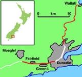
Dunedin Southern Motorway
Encyclopedia
The Dunedin Southern Motorway is the main arterial route south from the South Island
city of Dunedin
, part of New Zealand
's State Highway 1
. It is one of the world's southernmost motorways.
and the CBD
before rejoining as a single multiple-lane road at the Andersons Bay
intersection; a busy signal-controlled "T" intersection with SH1 and Andersons Bay Road in South Dunedin
.
From the intersection SH1 becomes a four lane median-divided road for 700 metres, crossing King Edward Street (South Dunedin
's main street) on twin overbridges at Kensington, until near the Glen, just north of Carisbrook
, where it narrows to a two-lane undivided road. The southbound lanes merge into one, while the northbound carriageway gains a lane from the South Road on-ramp. While this section meets most technical definitions of a motorway with full limited access including no pedestrian or cycle traffic, it is not designated a motorway by the NZ Transport Agency
due to its short length.
SH1 continues south as a two-lane limited-access road past Carisbrook and Caversham
. The Main South Line
parallels SH1 along the east side of the road. Known as the Caversham bypass, this section is subject to congestion during the morning and afternoon weekday peaks, being a bottleneck between the four-lane sections of SH1 immediately to the north and south.
From Andersons Bay to Barnes Drive, at the south end of Caversham, SH1 has an 80 km/h speed limit.
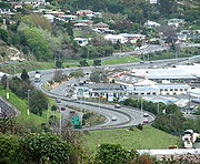
At the base of Calton Hill, SH1 intersects with Barnes Drive at a signal-controlled intersection. Here SH1 becomes a four-lane road before climbing over Calton Hill to Lookout Point. This section is residential arterial road with houses upon both sides and a 50 km/h speed limit enforced by a fixed speed camera about one third of the way up the hill. There are proposals to widen this road to connect the Caversham bypass with the motorway to the south.
Near the crest of Lookout Point, SH1 retains priority through an off-set intersection with Mornington Road and South Road, before heading southwards over the crest. At this point the motorway begins, with a concrete median divider and an increase in the speed limit to 100 km/h.
The motorway winds relatively steeply down past the site of the former Burnside
Freezing Works, and crosses the Main South Road/Kaikorai Valley
Road interchange on a bridge.
Once on the flat of the Kaikorai Valley the motorway passes underneath the northbound on-ramp from Green Island
before passing between the suburbs of Green Island and Abbotsford to the Green Island/Sunnyvale interchange.
Beyond this interchange the motorway crosses the Kaikorai Estuary and bisects the suburb of Fairfield
. There is a half diamond interchange at Old Brighton Road (northbound on, southbound off) before the motorway climbs towards its highest point, crossing a ridge of Saddle Hill
.
(A new overbridge was constructed to take Old Brighton Rd over the new motorway. This was named after W.G (Bill) Auld MBE, a local resident and dignatory who was a staunch advocate for the motorway bypassing Fairfield. He died shortly before the completion of the motorway but on the day of his funeral was 'driven' down the route he fought hard to implement.)
There is another half-diamond interchange (northbound off, southbound on) and a separate overbridge for Morris Road.
The motorway then descends from the slopes of Saddle Hill onto the floodplain of the Taieri River
at Mosgiel
. There is a full diamond interchange with SH 87
, the primary access to Mosgiel from SH1. At this point the motorway narrows to a two-lane undivided road. The motorway designation continues for a further 600 metres before continuing through the suburb of East Taieri.
A report from De Leuw Cather was commissioned by the Dunedin City Council in 1963, which recommended a number of changes primarily to Dunedin's arterial road system. A number of roads around the city were widened to four lanes, and the report recommended that investigation, design, and construction begin of the proposed southern motorway.
During this time period the then Ministry of Works designated a substantial amount of land for future upgrade works along SH1, with a view that by the late 1990s much of it would be rebuilt as motorway, possibly along the lines of a US Interstate, with bypasses of all small towns, grade separation of all intersections, and no private property accesses. Within the Dunedin area, Council planning maps from the 1960s and 1970s show a designation for a "Dunedin to Milton
Motorway" which is part of these Ministry of Works designations.
The present constructed motorway generally follows along the route of this early designation. Further evidence of the Ministry of Works intentions can be seen on the "flood-free" section of SH1 near Henley
on the Taieri Plains
, 35 km south of Dunedin
, where the two-lane road has a 2.5-metre shoulder on the northbound side and a standard 0.5-metre shoulder on the southbound. This two-lane road was constructed in the early 1970s as the northbound lanes of a motorway, with the intention that separate southbound lanes would be constructed in the future.
 The motorway was constructed in a number of sections.
The first section was completed in 1972 and bypassed the suburb of Green Island.This section began at the southern end of Kaikorai Valley Road at Burnside
, and travelled south for 2.5 kilometres, dividing Green Island
from Abbotsford. It ended at the southern end of Green Island, and connected with the main south road through Fairfield. Construction of this section of motorway is considered by some people to have been a causal factor of the Abbotsford Landslide in 1979.
Around the same time, construction began on the section traversing Saddle Hill, from Mosgiel
to Fairfield
. Earthworks were undertaken to allow for the construction of a four-lane motorway with northbound and southbound slip lanes extending from a future interchange with SH87 at Mosgiel. At the time the road was constructed with two lanes and a northbound passing lane northward from the SH1/SH87 intersection.
The second section was a short 700-metre section of four-lane dual carriageway completed in 1978. It extended southwards from the Andersons Bay intersection, across King Edward Street on twin bridges to connect with South Road near the Glen.
The 1980s saw the extension of the motorway south from the Glen to Barnes Drive, bypassing Caversham
. Due to funding constraints this section was only built as a single two-lane carriageway, albeit with no intersections.
SH1 from Barnes Drive to Lookout Point was upgraded with the addition of a second northbound lane, giving four lanes in total. Aberfeldy Street was limited to a left in/left out
intersection.
In 1987, due to high accident and congestion problems, the at-grade intersection with SH87 at Mosgiel was upgraded into a full diamond interchange. Under severe funding constraints the SH87 bridge was built to accommodate only two lanes of SH1 travelling underneath, which will make widening of SH1 at this point more costly.
In 1989-1990 the Green Island motorway was extended northwards up Calton Hill past the Burnside Freezing Works to re-connect with SH1 at Lookout Point.
A major extension was completed in 2003 when the 4.5-km Fairfield Bypass was opened. This connected the southern terminus of the Green Island Motorway with the northern end of the Saddle Hill section of SH1. There were several delays in construction of this stretch due to the presence of mine workings that created major difficulties in the stabilisation of the land along the route. The Saddle Hill section was upgraded at this time to a four-lane divided motorway to take advantage of the preparatory earthworks completed in the 1960s.
The completion of the Fairfield section meant that SH1 was now an uninterrupted four-lane divided motorway from Lookout Point to the SH87 interchange. construction is underway to widen the northbound route immediately north of the Saddle Hill saddle.
began upgrading SH1 from the Andersons Bay intersection to Lookout Point to a four-lane dual carriageway in January 2011.
. This would have re-aligned SH1 along this route and have extended the motorway southwards for several kilometres beyond its present terminus. A stretch of SH1 was realigned in this area during the 1970s, moved westward to avoid the edge of the coastal range of hills, and the junction with SH86
at Allanton was redesigned, but no further work towards a potential motorway extension was carried out. Transit New Zealand did not seek to renew the designation for this road in 2007 http://www.transit.govt.nz/news/MediaReleaseView.do?MediaReleaseId=nz.govt.transit.transweb.content.news.MediaRelease-12528, meaning that this project is now unlikely to proceed.
South Island
The South Island is the larger of the two major islands of New Zealand, the other being the more populous North Island. It is bordered to the north by Cook Strait, to the west by the Tasman Sea, to the south and east by the Pacific Ocean...
city of Dunedin
Dunedin
Dunedin is the second-largest city in the South Island of New Zealand, and the principal city of the Otago Region. It is considered to be one of the four main urban centres of New Zealand for historic, cultural, and geographic reasons. Dunedin was the largest city by territorial land area until...
, part of New Zealand
New Zealand
New Zealand is an island country in the south-western Pacific Ocean comprising two main landmasses and numerous smaller islands. The country is situated some east of Australia across the Tasman Sea, and roughly south of the Pacific island nations of New Caledonia, Fiji, and Tonga...
's State Highway 1
State Highway 1 (New Zealand)
State Highway 1 is the longest and most significant road in the New Zealand roading network, running the length of both main islands. It appears on road maps as SH 1 and on road signs as a white number 1 on a red shield, but it has the official designations SH 1N in the North Island, SH 1S in the...
. It is one of the world's southernmost motorways.
Route
SH1 traverses Dunedin as two multiple-lane one-way streets, travelling past the University of OtagoUniversity of Otago
The University of Otago in Dunedin is New Zealand's oldest university with over 22,000 students enrolled during 2010.The university has New Zealand's highest average research quality and in New Zealand is second only to the University of Auckland in the number of A rated academic researchers it...
and the CBD
Central business district
A central business district is the commercial and often geographic heart of a city. In North America this part of a city is commonly referred to as "downtown" or "city center"...
before rejoining as a single multiple-lane road at the Andersons Bay
Andersons Bay
Andersons Bay is a suburb of the New Zealand city of Dunedin. It is located in the southeast of the city's urban area, southeast of the city's centre...
intersection; a busy signal-controlled "T" intersection with SH1 and Andersons Bay Road in South Dunedin
South Dunedin
South Dunedin is a major inner city suburb of the New Zealand city of Dunedin. It is located, as its name suggests, to the south of the city centre, on part of a large plain known locally simply as "The Flat". The suburb is a mix of industrial, retail, and predominantly lower-quality residential...
.
From the intersection SH1 becomes a four lane median-divided road for 700 metres, crossing King Edward Street (South Dunedin
South Dunedin
South Dunedin is a major inner city suburb of the New Zealand city of Dunedin. It is located, as its name suggests, to the south of the city centre, on part of a large plain known locally simply as "The Flat". The suburb is a mix of industrial, retail, and predominantly lower-quality residential...
's main street) on twin overbridges at Kensington, until near the Glen, just north of Carisbrook
Carisbrook
Carisbrook was a major sporting venue in Dunedin, New Zealand. The city's main domestic and international rugby union venue, it has also been used for other sports such as cricket, football, rugby league and motocross. Carisbrook has also hosted a Joe Cocker concert and frequently hosted pre-game...
, where it narrows to a two-lane undivided road. The southbound lanes merge into one, while the northbound carriageway gains a lane from the South Road on-ramp. While this section meets most technical definitions of a motorway with full limited access including no pedestrian or cycle traffic, it is not designated a motorway by the NZ Transport Agency
New Zealand Transport Agency
The New Zealand Transport Agency is a New Zealand Crown entity tasked with promoting safe and functional transport by land, including the responsibility for driver and vehicle licensing and investigating rail accidents. It was created on 1 August 2008 by the Land Transport Management Amendment...
due to its short length.
SH1 continues south as a two-lane limited-access road past Carisbrook and Caversham
Caversham, New Zealand
Caversham is one of the older suburbs of the South Island New Zealand city of Dunedin. It is sited at the western edge of the city's central plain at the mouth of the steep Caversham Valley, which rises to the saddle of Lookout Point...
. The Main South Line
South Island Main Trunk Railway
The Main North Line between Picton and Christchurch and the Main South Line between Lyttelton and Invercargill, running down the east coast of the South Island of New Zealand, are sometimes together referred to as the South Island Main Trunk Railway...
parallels SH1 along the east side of the road. Known as the Caversham bypass, this section is subject to congestion during the morning and afternoon weekday peaks, being a bottleneck between the four-lane sections of SH1 immediately to the north and south.
From Andersons Bay to Barnes Drive, at the south end of Caversham, SH1 has an 80 km/h speed limit.
At the base of Calton Hill, SH1 intersects with Barnes Drive at a signal-controlled intersection. Here SH1 becomes a four-lane road before climbing over Calton Hill to Lookout Point. This section is residential arterial road with houses upon both sides and a 50 km/h speed limit enforced by a fixed speed camera about one third of the way up the hill. There are proposals to widen this road to connect the Caversham bypass with the motorway to the south.
Near the crest of Lookout Point, SH1 retains priority through an off-set intersection with Mornington Road and South Road, before heading southwards over the crest. At this point the motorway begins, with a concrete median divider and an increase in the speed limit to 100 km/h.
The motorway winds relatively steeply down past the site of the former Burnside
Burnside, Otago
Burnside is a mainly industrial suburb of the New Zealand city of Dunedin. It is located at the mouth of a long valley, the Kaikorai Valley, through which flows the Kaikorai Stream. This valley stretches to the northeast for . Burnside is to the southwest of the city centre, close to eastern end...
Freezing Works, and crosses the Main South Road/Kaikorai Valley
Kaikorai Valley
Kaikorai Valley is a long broad valley which runs through the west of the New Zealand city of Dunedin, to the west of the city centre. It is the valley of a small stream, the Kaikorai Stream,which runs from northeast to southwest down the length of the valley.The valley provides a route into...
Road interchange on a bridge.
Once on the flat of the Kaikorai Valley the motorway passes underneath the northbound on-ramp from Green Island
Green Island, New Zealand
Green Island is an island off the coast of Dunedin, New Zealand, also the name of one of the city's suburbs. The suburb is not on the sea — formerly a borough, it took its name from the Green Island bush, uncleared native forest extending from the valley where the town is centred over the hills...
before passing between the suburbs of Green Island and Abbotsford to the Green Island/Sunnyvale interchange.
Beyond this interchange the motorway crosses the Kaikorai Estuary and bisects the suburb of Fairfield
Fairfield, Otago
The quiet suburb of Fairfield lies 10 kilometres to the west of Dunedin CBD, in Otago, southern New Zealand.Fairfield lies in rolling hill country between Abbotsford and the Taieri Plains, close to the slopes of Saddle Hill and Scroggs Hill...
. There is a half diamond interchange at Old Brighton Road (northbound on, southbound off) before the motorway climbs towards its highest point, crossing a ridge of Saddle Hill
Saddle Hill, New Zealand
Saddle Hill is a prominent landmark overlooking the northeastern end of the Taieri Plains in Otago, New Zealand. Within the limits of Dunedin city, it is located 18 kilometres to the west of the city centre, between Mosgiel and Green Island, and is clearly visible from many of the city's southern...
.
(A new overbridge was constructed to take Old Brighton Rd over the new motorway. This was named after W.G (Bill) Auld MBE, a local resident and dignatory who was a staunch advocate for the motorway bypassing Fairfield. He died shortly before the completion of the motorway but on the day of his funeral was 'driven' down the route he fought hard to implement.)
There is another half-diamond interchange (northbound off, southbound on) and a separate overbridge for Morris Road.
The motorway then descends from the slopes of Saddle Hill onto the floodplain of the Taieri River
Taieri Plains
The Taieri Plains are an area of fertile agricultural land to the southwest of Dunedin, in Otago, New Zealand. The plains cover an area of some 300 square kilometres, with a maximum extent of 30 kilometres....
at Mosgiel
Mosgiel
Mosgiel is an urban satellite of Dunedin in Otago, New Zealand, fifteen kilometres west of the city's centre. Since the re-organisation of New Zealand local government in 1989 it has been inside the Dunedin City Council area, but was physically separate from the contiguous suburbs until...
. There is a full diamond interchange with SH 87
New Zealand State Highway network
The New Zealand State Highway network is the major national highway network in New Zealand. Just under 100 roads in both the North and South Islands are State Highways...
, the primary access to Mosgiel from SH1. At this point the motorway narrows to a two-lane undivided road. The motorway designation continues for a further 600 metres before continuing through the suburb of East Taieri.
History
A motorway extending south from the Andersons Bay intersection was first proposed from the late 1950s, when Dunedin, like other major centres in New Zealand, was experiencing rapid vehicle growth and a decline in public transport usage.http://www.dunedin.govt.nz/__data/assets/minutes_agenda/0004/44086/ma-r-is-20081124-Caversham-Report.pdfA report from De Leuw Cather was commissioned by the Dunedin City Council in 1963, which recommended a number of changes primarily to Dunedin's arterial road system. A number of roads around the city were widened to four lanes, and the report recommended that investigation, design, and construction begin of the proposed southern motorway.
During this time period the then Ministry of Works designated a substantial amount of land for future upgrade works along SH1, with a view that by the late 1990s much of it would be rebuilt as motorway, possibly along the lines of a US Interstate, with bypasses of all small towns, grade separation of all intersections, and no private property accesses. Within the Dunedin area, Council planning maps from the 1960s and 1970s show a designation for a "Dunedin to Milton
Milton, New Zealand
Milton is a town of 2,000 people, located on State Highway 1, 50 kilometres to the south of Dunedin in Otago, New Zealand. It lies on the floodplain of the Tokomairiro River, one branch of which loops past the north and south ends of the town...
Motorway" which is part of these Ministry of Works designations.
The present constructed motorway generally follows along the route of this early designation. Further evidence of the Ministry of Works intentions can be seen on the "flood-free" section of SH1 near Henley
Henley, New Zealand
Henley is a township on New Zealand's Taieri Plains, presumably named after the rowing centre Henley-on-Thames in England. It lies close to the confluence of the Taieri and Waipori Rivers at the eastern edge of the plain, at the foot of a low range of coastal hills.Henley is near the south-west...
on the Taieri Plains
Taieri Plains
The Taieri Plains are an area of fertile agricultural land to the southwest of Dunedin, in Otago, New Zealand. The plains cover an area of some 300 square kilometres, with a maximum extent of 30 kilometres....
, 35 km south of Dunedin
Dunedin
Dunedin is the second-largest city in the South Island of New Zealand, and the principal city of the Otago Region. It is considered to be one of the four main urban centres of New Zealand for historic, cultural, and geographic reasons. Dunedin was the largest city by territorial land area until...
, where the two-lane road has a 2.5-metre shoulder on the northbound side and a standard 0.5-metre shoulder on the southbound. This two-lane road was constructed in the early 1970s as the northbound lanes of a motorway, with the intention that separate southbound lanes would be constructed in the future.
Section-by-section construction
The first section was completed in 1972 and bypassed the suburb of Green Island.This section began at the southern end of Kaikorai Valley Road at Burnside
Burnside, Otago
Burnside is a mainly industrial suburb of the New Zealand city of Dunedin. It is located at the mouth of a long valley, the Kaikorai Valley, through which flows the Kaikorai Stream. This valley stretches to the northeast for . Burnside is to the southwest of the city centre, close to eastern end...
, and travelled south for 2.5 kilometres, dividing Green Island
Green Island, New Zealand
Green Island is an island off the coast of Dunedin, New Zealand, also the name of one of the city's suburbs. The suburb is not on the sea — formerly a borough, it took its name from the Green Island bush, uncleared native forest extending from the valley where the town is centred over the hills...
from Abbotsford. It ended at the southern end of Green Island, and connected with the main south road through Fairfield. Construction of this section of motorway is considered by some people to have been a causal factor of the Abbotsford Landslide in 1979.
Around the same time, construction began on the section traversing Saddle Hill, from Mosgiel
Mosgiel
Mosgiel is an urban satellite of Dunedin in Otago, New Zealand, fifteen kilometres west of the city's centre. Since the re-organisation of New Zealand local government in 1989 it has been inside the Dunedin City Council area, but was physically separate from the contiguous suburbs until...
to Fairfield
Fairfield, Otago
The quiet suburb of Fairfield lies 10 kilometres to the west of Dunedin CBD, in Otago, southern New Zealand.Fairfield lies in rolling hill country between Abbotsford and the Taieri Plains, close to the slopes of Saddle Hill and Scroggs Hill...
. Earthworks were undertaken to allow for the construction of a four-lane motorway with northbound and southbound slip lanes extending from a future interchange with SH87 at Mosgiel. At the time the road was constructed with two lanes and a northbound passing lane northward from the SH1/SH87 intersection.
The second section was a short 700-metre section of four-lane dual carriageway completed in 1978. It extended southwards from the Andersons Bay intersection, across King Edward Street on twin bridges to connect with South Road near the Glen.
The 1980s saw the extension of the motorway south from the Glen to Barnes Drive, bypassing Caversham
Caversham, New Zealand
Caversham is one of the older suburbs of the South Island New Zealand city of Dunedin. It is sited at the western edge of the city's central plain at the mouth of the steep Caversham Valley, which rises to the saddle of Lookout Point...
. Due to funding constraints this section was only built as a single two-lane carriageway, albeit with no intersections.
SH1 from Barnes Drive to Lookout Point was upgraded with the addition of a second northbound lane, giving four lanes in total. Aberfeldy Street was limited to a left in/left out
Right-in/right-out
Right-in/right-out and left-in/left-out refer to a type of road intersection where turning movements of vehicles are restricted. A RIRO permits only right turns and a LILO permits only left turns. RIRO is usual where vehicles drive on the right, and LILO is usual where vehicles drive on the left...
intersection.
In 1987, due to high accident and congestion problems, the at-grade intersection with SH87 at Mosgiel was upgraded into a full diamond interchange. Under severe funding constraints the SH87 bridge was built to accommodate only two lanes of SH1 travelling underneath, which will make widening of SH1 at this point more costly.
In 1989-1990 the Green Island motorway was extended northwards up Calton Hill past the Burnside Freezing Works to re-connect with SH1 at Lookout Point.
A major extension was completed in 2003 when the 4.5-km Fairfield Bypass was opened. This connected the southern terminus of the Green Island Motorway with the northern end of the Saddle Hill section of SH1. There were several delays in construction of this stretch due to the presence of mine workings that created major difficulties in the stabilisation of the land along the route. The Saddle Hill section was upgraded at this time to a four-lane divided motorway to take advantage of the preparatory earthworks completed in the 1960s.
The completion of the Fairfield section meant that SH1 was now an uninterrupted four-lane divided motorway from Lookout Point to the SH87 interchange. construction is underway to widen the northbound route immediately north of the Saddle Hill saddle.
Caversham Bypass
The NZ Transport AgencyNew Zealand Transport Agency
The New Zealand Transport Agency is a New Zealand Crown entity tasked with promoting safe and functional transport by land, including the responsibility for driver and vehicle licensing and investigating rail accidents. It was created on 1 August 2008 by the Land Transport Management Amendment...
began upgrading SH1 from the Andersons Bay intersection to Lookout Point to a four-lane dual carriageway in January 2011.
East Taieri Bypass
Land was designated in the early 1960s by the then Ministry of Works for a motorway corridor from the SH1/SH87 interchange southwards through East Taieri towards AllantonAllanton
Allanton is a small town in Otago, New Zealand, located some 20 kilometres southwest of Dunedin on State Highway 1. The settlement lies at the eastern edge of the Taieri Plains close to the Taieri River at the junction of the main road to Dunedin International Airport at Momona.Established near the...
. This would have re-aligned SH1 along this route and have extended the motorway southwards for several kilometres beyond its present terminus. A stretch of SH1 was realigned in this area during the 1970s, moved westward to avoid the edge of the coastal range of hills, and the junction with SH86
New Zealand State Highway 86
State Highway 86 is a New Zealand State Highway connecting the city of Dunedin's airport to State Highway 1 and the city itself. It is one of the more recent highways, gazetted in around 2003-04...
at Allanton was redesigned, but no further work towards a potential motorway extension was carried out. Transit New Zealand did not seek to renew the designation for this road in 2007 http://www.transit.govt.nz/news/MediaReleaseView.do?MediaReleaseId=nz.govt.transit.transweb.content.news.MediaRelease-12528, meaning that this project is now unlikely to proceed.
Junction list
| Territorial authority | Location | km | Destination | Notes |
|---|---|---|---|---|
| Dunedin City Dunedin Dunedin is the second-largest city in the South Island of New Zealand, and the principal city of the Otago Region. It is considered to be one of the four main urban centres of New Zealand for historic, cultural, and geographic reasons. Dunedin was the largest city by territorial land area until... |
 SH 1 Andersons Bay Road (north) – City Centre, Timaru SH 1 Andersons Bay Road (north) – City Centre, TimaruTimaru TimaruUrban AreaPopulation:27,200Extent:Former Timaru City CouncilTerritorial AuthorityName:Timaru District CouncilPopulation:42,867 Land area:2,736.54 km² Mayor:Janie AnnearWebsite:... Andersons Bay Road (south) – South Dunedin South Dunedin South Dunedin is a major inner city suburb of the New Zealand city of Dunedin. It is located, as its name suggests, to the south of the city centre, on part of a large plain known locally simply as "The Flat". The suburb is a mix of industrial, retail, and predominantly lower-quality residential... , Andersons Bay Andersons Bay Andersons Bay is a suburb of the New Zealand city of Dunedin. It is located in the southeast of the city's urban area, southeast of the city's centre... , Otago Peninsula Otago Peninsula The Otago Peninsula is a long, hilly indented finger of land that forms the easternmost part of Dunedin, New Zealand. Volcanic in origin, it forms one wall of the eroded valley that now forms Otago Harbour. The peninsula lies south-east of Otago Harbour and runs parallel to the mainland for... , bypass north |
Traffic light controlled intersection Dunedin Southern Motorway begins' |
||
| Caversham Caversham, New Zealand Caversham is one of the older suburbs of the South Island New Zealand city of Dunedin. It is sited at the western edge of the city's central plain at the mouth of the steep Caversham Valley, which rises to the saddle of Lookout Point... |
Southern Scenic Route Southern Scenic Route The Southern Scenic Route is a tourist highway in New Zealand linking Queenstown, Fiordland, Te Anau and the iconic Milford Road to Dunedin via, Riverton, Invercargill and The Catlins... Barnes Drive Caversham Caversham, New Zealand Caversham is one of the older suburbs of the South Island New Zealand city of Dunedin. It is sited at the western edge of the city's central plain at the mouth of the steep Caversham Valley, which rises to the saddle of Lookout Point... , South Dunedin, Carisbrook Carisbrook Carisbrook was a major sporting venue in Dunedin, New Zealand. The city's main domestic and international rugby union venue, it has also been used for other sports such as cricket, football, rugby league and motocross. Carisbrook has also hosted a Joe Cocker concert and frequently hosted pre-game... |
Traffic light controlled intersection | ||
| Burnett Street | ||||
| Aberfeldy Street | ||||
| Lookout Point | South Road – Corstorphine Corstorphine, New Zealand Corstorphine is a suburb of southwest Dunedin in the South Island of New Zealand. It is located on the slopes of Calton Hill - a spur of Forbury Hill - between Caversham Valley and the Pacific Ocean... |
|||
| Mornington Road – Mornington Mornington, Otago Mornington is a suburb of the city of Dunedin, in the South Island of New Zealand. It is situated on hilly slopes to the west of the city centre, the slopes forming part of a ridge which surrounds the heart of the city.... |
||||
| Main South Road – Concord, Burnside Burnside, Otago Burnside is a mainly industrial suburb of the New Zealand city of Dunedin. It is located at the mouth of a long valley, the Kaikorai Valley, through which flows the Kaikorai Stream. This valley stretches to the northeast for . Burnside is to the southwest of the city centre, close to eastern end... |
Southbound exit and northbound entrance Motorway designation begins |
|||
| Burnside Burnside, Otago Burnside is a mainly industrial suburb of the New Zealand city of Dunedin. It is located at the mouth of a long valley, the Kaikorai Valley, through which flows the Kaikorai Stream. This valley stretches to the northeast for . Burnside is to the southwest of the city centre, close to eastern end... |
Main South Road – Kaikorai Valley Kaikorai Valley Kaikorai Valley is a long broad valley which runs through the west of the New Zealand city of Dunedin, to the west of the city centre. It is the valley of a small stream, the Kaikorai Stream,which runs from northeast to southwest down the length of the valley.The valley provides a route into... , Concord, Green Island Green Island, New Zealand Green Island is an island off the coast of Dunedin, New Zealand, also the name of one of the city's suburbs. The suburb is not on the sea — formerly a borough, it took its name from the Green Island bush, uncleared native forest extending from the valley where the town is centred over the hills... |
Northbound exit and southbound entrance | ||
| Green Island Green Island, New Zealand Green Island is an island off the coast of Dunedin, New Zealand, also the name of one of the city's suburbs. The suburb is not on the sea — formerly a borough, it took its name from the Green Island bush, uncleared native forest extending from the valley where the town is centred over the hills... |
Main South Road – Green Island Green Island, New Zealand Green Island is an island off the coast of Dunedin, New Zealand, also the name of one of the city's suburbs. The suburb is not on the sea — formerly a borough, it took its name from the Green Island bush, uncleared native forest extending from the valley where the town is centred over the hills... , Abbotsford |
Southbound exit only | ||
| Sunnyvale Sunnyvale, New Zealand Sunnyvale is the name of two places in New Zealand:*Sunnyvale, Auckland is a suburb of Auckland*Sunnyvale, Otago is a suburb of Dunedin... |
Main South Road – Abbotsford, Brighton Brighton, New Zealand "Ocean View, New Zealand" redirects here. For the inner Dunedin suburb occasionally referred to as Ocean View, see Andersons BayBrighton is a small seaside town within the city limits of Dunedin, in New Zealand's South Island. It is located 20 kilometres southwest from the city centre on the... , Green Island |
|||
| Fairfield Fairfield, Otago The quiet suburb of Fairfield lies 10 kilometres to the west of Dunedin CBD, in Otago, southern New Zealand.Fairfield lies in rolling hill country between Abbotsford and the Taieri Plains, close to the slopes of Saddle Hill and Scroggs Hill... |
Old Brighton Road – Fairfield, Saddle Hill Saddle Hill, New Zealand Saddle Hill is a prominent landmark overlooking the northeastern end of the Taieri Plains in Otago, New Zealand. Within the limits of Dunedin city, it is located 18 kilometres to the west of the city centre, between Mosgiel and Green Island, and is clearly visible from many of the city's southern... |
Southbound exit and northbound entrance | ||
| Saddle Hill Road – Fairfield, Saddle Hill | Northbound exit and southbound entrance | |||
 SH 87 Quarry Road – Mosgiel SH 87 Quarry Road – MosgielMosgiel Mosgiel is an urban satellite of Dunedin in Otago, New Zealand, fifteen kilometres west of the city's centre. Since the re-organisation of New Zealand local government in 1989 it has been inside the Dunedin City Council area, but was physically separate from the contiguous suburbs until... |
||||
| Braeside | Dunedin Southern Motorway and motorway designation end | |||
| SH 1– Airport Dunedin International Airport Dunedin International Airport is an international airport in the Otago region of the South Island of New Zealand, serving Dunedin city and the Otago and Southland regions. Dunedin International Airport is one of two international airports in Otago, the other being Queenstown International Airport... , Invercargill Invercargill Invercargill is the southernmost and westernmost city in New Zealand, and one of the southernmost cities in the world. It is the commercial centre of the Southland region. It lies in the heart of the wide expanse of the Southland Plains on the Oreti or New River some 18 km north of Bluff,... |