

Cadastral divisions of Australia
Encyclopedia
Australia
Australia , officially the Commonwealth of Australia, is a country in the Southern Hemisphere comprising the mainland of the Australian continent, the island of Tasmania, and numerous smaller islands in the Indian and Pacific Oceans. It is the world's sixth-largest country by total area...
which are divided into the cadastral
Cadastre
A cadastre , using a cadastral survey or cadastral map, is a comprehensive register of the metes-and-bounds real property of a country...
units of counties
County
A county is a jurisdiction of local government in certain modern nations. Historically in mainland Europe, the original French term, comté, and its equivalents in other languages denoted a jurisdiction under the sovereignty of a count A county is a jurisdiction of local government in certain...
, parishes, hundreds, and other divisions for the purposes of land ownership. Many property titles in Australia are listed as being in the parish and county.
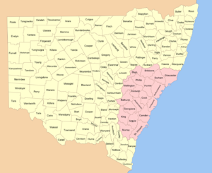
The whole of the eastern states of Queensland
Queensland
Queensland is a state of Australia, occupying the north-eastern section of the mainland continent. It is bordered by the Northern Territory, South Australia and New South Wales to the west, south-west and south respectively. To the east, Queensland is bordered by the Coral Sea and Pacific Ocean...
, New South Wales
New South Wales
New South Wales is a state of :Australia, located in the east of the country. It is bordered by Queensland, Victoria and South Australia to the north, south and west respectively. To the east, the state is bordered by the Tasman Sea, which forms part of the Pacific Ocean. New South Wales...
, Victoria
Victoria (Australia)
Victoria is the second most populous state in Australia. Geographically the smallest mainland state, Victoria is bordered by New South Wales, South Australia, and Tasmania on Boundary Islet to the north, west and south respectively....
and Tasmania
Tasmania
Tasmania is an Australian island and state. It is south of the continent, separated by Bass Strait. The state includes the island of Tasmania—the 26th largest island in the world—and the surrounding islands. The state has a population of 507,626 , of whom almost half reside in the greater Hobart...
were divided into counties and parishes in the 19th century, although the Tasmanian counties were renamed land districts in the twentieth century. Parts of South Australia
South Australia
South Australia is a state of Australia in the southern central part of the country. It covers some of the most arid parts of the continent; with a total land area of , it is the fourth largest of Australia's six states and two territories.South Australia shares borders with all of the mainland...
(south-east) and Western Australia
Western Australia
Western Australia is a state of Australia, occupying the entire western third of the Australian continent. It is bounded by the Indian Ocean to the north and west, the Great Australian Bight and Indian Ocean to the south, the Northern Territory to the north-east and South Australia to the south-east...
(south-west) were similarly divided into counties, and there were also five counties in a small part of the Northern Territory
Northern Territory
The Northern Territory is a federal territory of Australia, occupying much of the centre of the mainland continent, as well as the central northern regions...
. However South Australia has subdivisions of hundreds instead of parishes, along with the Northern Territory, which was part of South Australia when the hundreds were proclaimed. There were also formerly hundreds in Tasmania. There have been at least 600 counties, 544 hundreds and at least 15,692 parishes in Australia, but there are none of these units for most of the sparsely inhabited central and western parts of the country.
Counties in Australia have no administrative or political function, unlike those in England and the United States
County (United States)
In the United States, a county is a geographic subdivision of a state , usually assigned some governmental authority. The term "county" is used in 48 of the 50 states; Louisiana is divided into parishes and Alaska into boroughs. Parishes and boroughs are called "county-equivalents" by the U.S...
. Australia instead uses Local Government Areas, including shire
Shire
A shire is a traditional term for a division of land, found in the United Kingdom and in Australia. In parts of Australia, a shire is an administrative unit, but it is not synonymous with "county" there, which is a land registration unit. Individually, or as a suffix in Scotland and in the far...
s, districts, council
City council
A city council or town council is the legislative body that governs a city, town, municipality or local government area.-Australia & NZ:Because of the differences in legislation between the States, the exact definition of a City Council varies...
s and municipalities
Municipality
A municipality is essentially an urban administrative division having corporate status and usually powers of self-government. It can also be used to mean the governing body of a municipality. A municipality is a general-purpose administrative subdivision, as opposed to a special-purpose district...
according to the state, as the second level subdivision.
Torrens title
Torrens title is a system of land title where a register of land holdings maintained by the state guarantees an indefeasible title to those included in the register...
system of a central register of land holdings in South Australia in 1858, which spread to the other colonies. While cadastral data since the 1980s has been digitalised, there remain many old maps showing these divisions held in collections of Australian libraries such as the National Library of Australia
National Library of Australia
The National Library of Australia is the largest reference library of Australia, responsible under the terms of the National Library Act for "maintaining and developing a national collection of library material, including a comprehensive collection of library material relating to Australia and the...
, as well as in state libraries.
History
History of Australia (1788-1850)
The history of Australia from 1788–1850 covers the early colonies period of Australia's history, from the arrival of the First Fleet of British ships at Sydney to establish the penal colony of New South Wales in 1788 to the European exploration of the continent and establishment of other colonies...
in Australia, with the County of Cumberland
Cumberland County, New South Wales
Cumberland County is a county in the State of New South Wales, Australia. Most of the Sydney metropolitan area is located within the County of Cumberland....
proclaimed by Captain Phillip
Arthur Phillip
Admiral Arthur Phillip RN was a British admiral and colonial administrator. Phillip was appointed Governor of New South Wales, the first European colony on the Australian continent, and was the founder of the settlement which is now the city of Sydney.-Early life and naval career:Arthur Phillip...
on 4 June 1788. In 1804 Governor King
Philip Gidley King
Captain Philip Gidley King RN was a British naval officer and colonial administrator. He is best known as the official founder of the first European settlement on Norfolk Island and as the third Governor of New South Wales.-Early years and establishment of Norfolk Island settlement:King was born...
divided Van Diemen's Land
Van Diemen's Land
Van Diemen's Land was the original name used by most Europeans for the island of Tasmania, now part of Australia. The Dutch explorer Abel Tasman was the first European to land on the shores of Tasmania...
into two counties; Buckingham in the south and Cornwall in the north. The parishes date to the surveys conducted after 1825, with the instructions given to Governor Brisbane
Thomas Brisbane
Major-General Sir Thomas Makdougall Brisbane, 1st Baronet GCH, GCB, FRS, FRSE was a British soldier, colonial Governor and astronomer.-Early life:...
on 23 Jun 1825 to divide the colony into counties, hundreds and parishes. At this time there were five counties already proclaimed in New South Wales: Cumberland
Cumberland County, New South Wales
Cumberland County is a county in the State of New South Wales, Australia. Most of the Sydney metropolitan area is located within the County of Cumberland....
, Westmoreland
Westmoreland County, New South Wales
Westmoreland County was one of the original Nineteen Counties in New South Wales and is now one of the 141 Cadastral divisions of New South Wales. It is to the west of Sydney in the Blue Mountains. Coxs River is the border to the north, and the Wollondilly River to the east...
, Camden
Camden County, New South Wales
Camden County was one of the original Nineteen Counties in New South Wales and is now one of the 141 Cadastral divisions of New South Wales. It included the coastal area near Wollongong south to the Shoalhaven River, and also inland encompassing Berrima and Picton. Its western boundary was the...
, Argyle
Argyle County, New South Wales
Argyle County was one of the original Nineteen Counties in New South Wales and is now one of the 141 Cadastral divisions of New South Wales. It includes the area around Goulburn. It is bounded by Lake George in the south-west, the Shoalhaven River in the east, and the Wollondilly River in the...
and Northumberland
Northumberland County, New South Wales
Northumberland County was one of the original Nineteen Counties in New South Wales and is now one of the 141 Cadastral divisions of New South Wales. It included the area to the north of Broken Bay, including Lake Macquarie and Newcastle...
. The Nineteen Counties
Nineteen Counties
The Nineteen Counties were the limits of location in the colony of New South Wales defined by the Governor of New South Wales Sir Ralph Darling in 1826 in accordance with a government order from Lord Bathurst, the secretary of State. Counties had been used since the first year of settlement, with...
in south eastern New South Wales were the limits of location of the colony in a period after 1829, with the area outside them originally divided into districts, and later also into counties and parishes. Counties were established soon after the foundation of other Australian colonies.
Many of the counties have English names, often the names of counties in England, such as Devon, Dorset, Cornwall and Kent Counties in Tasmania. Less frequently, some have Aboriginal names such as the County of Yungnulgra
Yungnulgra County, New South Wales
Yungnulgra County is one of the 141 Cadastral divisions of New South Wales.The name Yungnulgra is believed to be derived from a local Aboriginal word and is also the name used for Yungnulgra Plains.- Parishes within this county:...
in New South Wales, and County of Croajingolong
County of Croajingolong
The County of Croajingolong is one of the 37 counties of Victoria which are part of the cadastral divisions of Australia, used for land titles. It is the most easterly county, and includes the Croajingolong National Park. Its western boundary is the Snowy River. The county was proclaimed in 1871...
in Victoria.
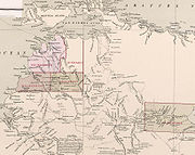
The use of counties, hundreds and parishes was popular in Australia in the 19th century, with many maps of Australian colonies showing these divisions, and towns and cities often listed in their county. Legal cases referenced counties http://www.law.mq.edu.au/scnsw/Cases1831-32/html/r_v_webber__1831.htm, and many genealogical records for Australia in the 19th century list the county and parish for location of birth, deaths and marriages http://www.une.edu.au/archives/maps1-100.html http://freepages.genealogy.rootsweb.com/~yewenyi/23693.htm http://wc.rootsweb.com/cgi-bin/igm.cgi?op=GET&db=yewenyi&id=I329. The 1911 Britannica
Encyclopædia Britannica Eleventh Edition
The Encyclopædia Britannica Eleventh Edition is a 29-volume reference work, an edition of the Encyclopædia Britannica. It was developed during the encyclopaedia's transition from a British to an American publication. Some of its articles were written by the best-known scholars of the time...
also describes Australian towns and cities as being in their respective county, including most of the capital cities:
Melbourne
Melbourne
Melbourne is the capital and most populous city in the state of Victoria, and the second most populous city in Australia. The Melbourne City Centre is the hub of the greater metropolitan area and the Census statistical division—of which "Melbourne" is the common name. As of June 2009, the greater...
, County of Bourke http://www.1911encyclopedia.org/Melbourne,_Australia; Sydney
Sydney
Sydney is the most populous city in Australia and the state capital of New South Wales. Sydney is located on Australia's south-east coast of the Tasman Sea. As of June 2010, the greater metropolitan area had an approximate population of 4.6 million people...
, County of Cumberland
Cumberland County, New South Wales
Cumberland County is a county in the State of New South Wales, Australia. Most of the Sydney metropolitan area is located within the County of Cumberland....
http://www.1911encyclopedia.org/Sydney,_Australia;Brisbane
Brisbane
Brisbane is the capital and most populous city in the Australian state of Queensland and the third most populous city in Australia. Brisbane's metropolitan area has a population of over 2 million, and the South East Queensland urban conurbation, centred around Brisbane, encompasses a population of...
, County of Stanley
County of Stanley, Queensland
The County of Stanley is a county in Queensland, Australia. Like all counties in Queensland, it is a non-functional administrative unit, that is used mainly for the purpose of registering land titles. It was named after Edward Stanley, who was three times British Prime Minister in the 1850s and...
http://www.1911encyclopedia.org/Brisbane; Adelaide
Adelaide
Adelaide is the capital city of South Australia and the fifth-largest city in Australia. Adelaide has an estimated population of more than 1.2 million...
, County of Adelaide; and Hobart
Hobart
Hobart is the state capital and most populous city of the Australian island state of Tasmania. Founded in 1804 as a penal colony,Hobart is Australia's second oldest capital city after Sydney. In 2009, the city had a greater area population of approximately 212,019. A resident of Hobart is known as...
, County of Buckingham http://www.1911encyclopedia.org/Hobart. However it is not mentioned that Perth
Perth, Western Australia
Perth is the capital and largest city of the Australian state of Western Australia and the fourth most populous city in Australia. The Perth metropolitan area has an estimated population of almost 1,700,000....
was located in the County of Perthhttp://www.1911encyclopedia.org/Perth,_Australia, as even by this time county names were infrequently used in Western Australia, where they did not cover all of the settled areas, unlike the other states. Instead the system of land divisions and land districts was used, with most of Perth located in the land districts of Swan
Swan Land District
Swan Land District is one of the land districts of Western Australia, which is located within the South West Division. It covers all of the northern and eastern suburbs of Perth, as well as some inner southern areas such as Belmont and Applecross and the area to the north up to the Moore River,...
, Canning
Canning Land District
Canning Land District is a land district of Western Australia, located within the South West Division in the eastern and south-eastern suburbs of metropolitan Perth....
and Cockburn Sound
Cockburn Sound Land District
Cockburn Sound Land District is a land district of Western Australia, located within the South West Division....
, all in the South West Division of Western Australia.
Counties and parishes are also still referenced in property law
Property law
Property law is the area of law that governs the various forms of ownership in real property and in personal property, within the common law legal system. In the civil law system, there is a division between movable and immovable property...
, and in industrial relations instruments
Labour and employment law
Labour law is the body of laws, administrative rulings, and precedents which address the legal rights of, and restrictions on, working people and their organizations. As such, it mediates many aspects of the relationship between trade unions, employers and employees...
, for example in a New South Wales award which excludes people from the County of Yancowinna
Yancowinna County, New South Wales
Yancowinna County is one of the 141 Cadastral divisions of New South Wales. It contains the city of Broken Hill and village of Silverton.Some New South Wales industrial relations laws have excluded the county of Yancowinna...
. Similar award examples exist in the other states and territories that have been subdivided into counties. The County of Yancowinna is also the only part of New South Wales which is in a different time zone to the rest of the state, as mentioned in the Australian Standard Time Act of 1987 http://www.aph.gov.au/LIBRARY/pubs/rn/2006-07/07rn13.htm. Counties are also used on paperwork for mortgage securities in banks. Parishes and counties are also mentioned in definitions of electoral districts.
Usage
Population density
Population density is a measurement of population per unit area or unit volume. It is frequently applied to living organisms, and particularly to humans...
, they have little relevance. The counties which contain the capital cities have millions of people, while those in remote areas have a very small population. The County of Adelaide, for instance, has a larger population than all the other counties in South Australia combined. Another reason is that many of the counties' borders follow rivers, having been proclaimed before settlements developed, which means that towns which typically grow up on rivers often find themselves in more than one county. Wangaratta, for instance, is located at the junction of the Ovens
Ovens River
The Ovens River is a river in the Australian state of Victoria.Hamilton Hume and William Hovell explored the area in 1824, naming the Ovens River...
and King
King River (Victoria)
King River is a river in Victoria, a state of Australia. It is a tributary of the Ovens River and ultimately the Murray River on the western slopes of the Australian Alps. The King Valley is a beautiful, cool climate wine grape growing area. It is a river used by kayaking enthusiasts with many...
rivers, and is thus in three counties; Moira
County of Moira
The County of Moira is one of the 37 counties of Victoria which are part of the cadastral divisions of Australia, used for land titles. It is located to the east of the Goulburn River, south of the Murray River, and west of part of the Ovens River. Part of Wangaratta is in the county, on the...
, Delatite
County of Delatite
The County of Delatite is one of the 37 counties of Victoria which are part of the cadastral divisions of Australia, used for land titles. It is located south west of Ovens River...
and Bogong
County of Bogong
The County of Bogong is one of the 37 counties of Victoria which are part of the cadastral divisions of Australia, used for land titles. It is located south of the Murray River, east of the Ovens River, and west of the Mitta Mitta River. Mount Bogong is located there, the highest mountain in...
.
Some of the county names live on by being the same name of present-day local government areas, general region names, towns or establishments in the area. For instance, the current Shire of Plantagenet and Shire of Victoria Plains in Western Australia are in the similar area to the County of Plantagenet
Plantagenet County, Western Australia
Plantagenet County was one of the 26 counties of Western Australia that were designated in 1829 as cadastral divisions, and was centred on the coastal settlement of Albany. It approximately corresponds to the modern-day Plantagenet Land District which forms the basis for land titles in the area.-...
and County of Victoria
Victoria County, Western Australia
Victoria County was one of the twenty six counties of Western Australia that were designated in 1829. It approximately corresponds to the north-western section of the Avon Land District which forms the basis for land titles in the area....
, respectively. The modern city of Devonport
Devonport, Tasmania
-Sport:The Devonport Football Club is an Australian Rules team competing in the Tasmanian Statewide League. The Devonport Rugby Club is a Rugby Union team competing in the Tasmanian Rugby Union Statewide League...
in Tasmania is located in the County of Devon. Some regions do promote the county name, such as Argyle County, while the County of Cadell
Cadell County, New South Wales
Cadell County is one of the 141 Cadastral divisions of New South Wales. It contains the city of Moama.Cadell County was named in honour of Francis Cadell , river navigator and entrepreneur.- Parishes within this county:...
(roughly in the Murray Shire area) is still the name for a vineyard and motor lodge in the same area.
Australian Capital Territory
Australian Capital Territory
The Australian Capital Territory, often abbreviated ACT, is the capital territory of the Commonwealth of Australia and is the smallest self-governing internal territory...
was made from land in the New South Wales counties of Murray
Murray County, New South Wales
Murray County was one of the original Nineteen Counties in New South Wales and is now one of the 141 Lands administrative divisions of New South Wales. It included the area which is now part of Canberra and as far north as Lake George and Yass. It was originally bounded on the west by the...
and Cowley
Cowley County, New South Wales
Cowley County is one of the 141 Cadastral divisions of New South Wales. It contains the locality of Cavan. It was originally bordered on the north, east and part of the south by the Murrumbidgee River, and on the west by the Goodradigbee River...
. This includes four former parishes of Canberra, Yarrolumla, Narrabundah and Gigerline in Murray and 15 former parishes in Cowley, while land in parts of other parishes of these counties also became part of the ACT. Also, in 1915, part of the Parish of Bherwerre in the County of St Vincent was transferred to the federal government to become the Jervis Bay Territory
Jervis Bay Territory
The Jervis Bay Territory is a territory of the Commonwealth of Australia. It was surrendered by the state of New South Wales to the Commonwealth Government in 1915 so that the Federal capital at Canberra would have "access to the sea"....
, which was part of the ACT until self-government in 1989. Murray lies east of the Murrumbidgee River
Murrumbidgee River
The Murrumbidgee River is a major river in the state of New South Wales, Australia, and the Australian Capital Territory . A major tributary of the Murray River, the Murrumbidgee flows in a west-northwesterly direction from the foot of Peppercorn Hill in the Fiery Range of the Snowy Mountains,...
, with all of what is now Canberra
Canberra
Canberra is the capital city of Australia. With a population of over 345,000, it is Australia's largest inland city and the eighth-largest city overall. The city is located at the northern end of the Australian Capital Territory , south-west of Sydney, and north-east of Melbourne...
within it, with Cowley to the west of the river. Parishes and counties are not currently used in ACT titles. Instead, the Districts Act 1966 divided the ACT into 18 districts: Canberra Central
Canberra Central
The District of Canberra Central is one of the 18 districts of the Australian Capital Territory used in land administration. It is subdivided into divisions , sections and blocks. It is mentioned in the . It includes the Inner North and Inner South...
(which includes Inner North
North Canberra
North Canberra, also known as the Inner North, is a district of Canberra, the capital city of Australia, comprising 14 suburbs with 19,115 dwellings housing 42,113 people of the 324,034 people in the Australian Capital Territory...
and Inner South
South Canberra
South Canberra or the Inner South is a central district of Canberra, the capital city of Australia.South Canberra is located to the south of Canberra's city centre, on the south bank of Lake Burley Griffin....
Canberra), Woden Valley
Woden Valley
Woden Valley is a district of Canberra, the capital city of Australia. Its name is taken from the name of a nearby homestead owned by Dr James Murray who named the homestead after the Old English god Woden in October 1837. He named it this as he was to spend his life in the pursuit of wisdom and...
, Belconnen
Belconnen
Belconnen is a district of Canberra, the capital city of Australia, comprising 25 suburbs with 29,900 dwellings housing 82,247 people of the 311,518 people in the Australian Capital Territory ....
, Jerrabomberra, Majura, Tuggeranong
Tuggeranong
Tuggeranong is the southernmost town centre of Canberra, the capital city of Australia. It comprises 19 suburbs with a total of 31,819 dwellings, housing 87,119 people of the 324,034 people in the Australian Capital Territory . The district occupies 117 square kilometres to the east of the...
, Weston Creek
Weston Creek
Weston Creek is a residential district of Canberra, Australian Capital Territory, Australia, situated to the west of the Woden Valley district and approximately 13 km southwest of the Canberra city centre...
, Gungahlin
Gungahlin
Gungahlin is a name of a district and the northernmost town centre of Canberra, Australia. Gungahlin is situated 10 km north of Canberra's city centre and is one of five satellites of Canberra including Woden, Tuggeranong, Weston Creek and Belconnen. Currently Gungahlin comprises 11 suburbs,...
, Stromlo
Mount Stromlo
Mount Stromlo is situated a short drive west of the centre of Canberra, Australia, near the district of Weston Creek. Its peak is at approximately 770m AHD....
, Kowen
Kowen
The Kowen District was designated by the Districts Act of 1966 as one of the 18 districts of the Australian Capital Territory . It is situated in the northeast corner of the ACT, to the east of Sutton Road and the town of Queanbeyan, New South Wales. Kowen is primarily covered by pine forests, and...
, Hall
Hall, Australian Capital Territory
Hall is a small town in the north of the Australian Capital Territory , Australia. It was founded in 1882, named after the first landholder in the area, Henry Hall. In 1911 Hall was included within the boundary of the land allocated for the Australian Capital Territory, close to the north western...
, Coree
Mount Coree
Mount Coree is a mountain located on the border between the Australian Capital Territory and New South Wales, Australia. It is located in Brindabella National Park on the NSW side, and Namadgi National Park on the ACT side. It has an elevation of 1421 metres...
, Paddys River
Paddys River
-References:...
, Cotter River
Cotter River
The Cotter River is a fresh water river in the Australian Capital Territory. It is a tributary of the Murrumbidgee River and part of Murray-Darling Basin. The Cotter River is one of two rivers—the Queanbeyan River is the other—that meet the water supply needs of the Canberra and...
, Tennent
Mount Tennent
Mount Tennent is a mountain in the southern part of the Australian Capital Territory. At the base of the mountain flows the Gudgenby River and this is a site for the proposed Mount Tennent Dam....
, Rendezvous Creek, Booth and Mount Clear. The parts of these located in Canberra itself are divided into divisions (i.e. suburbs), sections and blocks. For example, the National Library of Australia
National Library of Australia
The National Library of Australia is the largest reference library of Australia, responsible under the terms of the National Library Act for "maintaining and developing a national collection of library material, including a comprehensive collection of library material relating to Australia and the...
is located in Section 27, Blocks 4, 5 and 8, Division of Parkes
Parkes, Australian Capital Territory
Parkes is an inner suburb of Canberra, Australian Capital Territory, Australia. Located south of the Canberra CBD, Parkes contains the Parliamentary Triangle area. On Census night 2006, Parkes had a population of 4 people....
, District of Central Canberra
New South Wales
There are 141 counties and 7,459 parishes within New South Wales. The County of Cumberland
Cumberland County, New South Wales
Cumberland County is a county in the State of New South Wales, Australia. Most of the Sydney metropolitan area is located within the County of Cumberland....
, in which Sydney
Sydney
Sydney is the most populous city in Australia and the state capital of New South Wales. Sydney is located on Australia's south-east coast of the Tasman Sea. As of June 2010, the greater metropolitan area had an approximate population of 4.6 million people...
is located, has the largest population. The original Nineteen Counties
Nineteen Counties
The Nineteen Counties were the limits of location in the colony of New South Wales defined by the Governor of New South Wales Sir Ralph Darling in 1826 in accordance with a government order from Lord Bathurst, the secretary of State. Counties had been used since the first year of settlement, with...
were the limits of settlement in the early part of the 19th century. Legal documents describe the Lot number, Deposited Plan number, Parish and County. For example the Sydney Opera House
Sydney Opera House
The Sydney Opera House is a multi-venue performing arts centre in the Australian city of Sydney. It was conceived and largely built by Danish architect Jørn Utzon, finally opening in 1973 after a long gestation starting with his competition-winning design in 1957...
is described as being in Lot 5 in Deposited Plan 775888 at Bennelong Point, Parish of St. James
St. James Parish, Cumberland
St James Parish, Cumberland is one of the 57 parishes of Cumberland County, New South Wales, a cadastral unit for use on land titles. It is one of the four small parishes in the Sydney city area, which is named after the Anglican church of St James, which was consecrated in 1824...
, County
of Cumberland
Cumberland County, New South Wales
Cumberland County is a county in the State of New South Wales, Australia. Most of the Sydney metropolitan area is located within the County of Cumberland....
, city of Sydney Note that the land administration counties are not the same as the county councils that have been used to administer water and electricity, such as the Goldenfields Water County Council. or Central Tablelands County Council which do not correspond with a land administration county. However, there have been some land administration counties which did have county councils: Cumberland
Cumberland County, New South Wales
Cumberland County is a county in the State of New South Wales, Australia. Most of the Sydney metropolitan area is located within the County of Cumberland....
(1945–63), Northumberland
Northumberland County, New South Wales
Northumberland County was one of the original Nineteen Counties in New South Wales and is now one of the 141 Cadastral divisions of New South Wales. It included the area to the north of Broken Bay, including Lake Macquarie and Newcastle...
(1948–63) and Rous
Rous County, New South Wales
Rous County is one of the 141 Cadastral divisions of New South Wales. It is located at the north-east tip of the state. It is bordered on the north by the border with Queensland and on the south by the Richmond River...
(1940-pres., with trading name of Rous Water
Northern Territory
- County of Disraeli
- County of Malmesbury
- County of PalmerstonPalmerston County, Northern TerritoryPalmerston County is one of the five counties in the Northern Territory which are part of the Lands administrative divisions of Australia. It contains the city of Darwin. It was proclaimed in the 1860s, and divided into hundreds. It is bounded by Disraeli County to the east, Roseberry County to the...
(containing DarwinDarwin, Northern TerritoryDarwin is the capital city of the Northern Territory, Australia. Situated on the Timor Sea, Darwin has a population of 127,500, making it by far the largest and most populated city in the sparsely populated Northern Territory, but the least populous of all Australia's capital cities...
) - County of RoseberryRoseberry County, Northern TerritoryRoseberry County is one of the five counties in the Northern Territory which are part of the cadastral divisions of Australia....
(containing Pine CreekPine Creek, Northern TerritoryPine Creek is a small town in the Katherine region of the Northern Territory, Australia. According to the 2001 Australian census 665 people live in Pine Creek, which is the fourth largest town between Darwin and Alice Springs....
)
- County of Gladstone (separate from the others, in south-eastern Arnhem LandArnhem LandThe Arnhem Land Region is one of the five regions of the Northern Territory of Australia. It is located in the north-eastern corner of the territory and is around 500 km from the territory capital Darwin. The region has an area of 97,000 km² which also covers the area of Kakadu National...
in the Roper RiverRoper RiverThe Roper River is one of the largest rivers in the Northern Territory, Australia, extending east for over 500 km to meet the sea in Limmen Bight on the Gulf of Carpentaria. It is navigable for about 145 km, until the tidal limit at Roper Bar, and forms the southern boundary of the region...
area)
Darwin is located in the Hundred of Bagot
Hundred of Bagot
The Hundred of Bagot is the cadastral unit of hundred for the city of Darwin, Northern Territory and also encompassing the city of Palmerston. It is one of the 14 hundreds that were proclaimed in the County of Palmerston...
in the County of Palmerston
Palmerston County, Northern Territory
Palmerston County is one of the five counties in the Northern Territory which are part of the Lands administrative divisions of Australia. It contains the city of Darwin. It was proclaimed in the 1860s, and divided into hundreds. It is bounded by Disraeli County to the east, Roseberry County to the...
: usually only the hundred name, not the county, is mentioned. This is divided into sections. An example of the way locations are described for Darwin is Darwin Airport
Darwin International Airport
Darwin International Airport is the busiest airport serving the Northern Territory and the tenth busiest airport in Australia. It is the only airport serving Darwin....
listed as being in "Section 3381, Hundred of Bagot from plan LT089/067A" In Alice Springs, where there are no hundreds or counties, legal documents give the lot number, town and plan number, for example "Lot 8721 Town of Alice Springs, plan(s) LTO96/016"
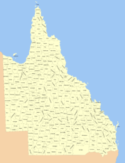
Queensland
County of Stanley, Queensland
The County of Stanley is a county in Queensland, Australia. Like all counties in Queensland, it is a non-functional administrative unit, that is used mainly for the purpose of registering land titles. It was named after Edward Stanley, who was three times British Prime Minister in the 1850s and...
containing Brisbane
Brisbane
Brisbane is the capital and most populous city in the Australian state of Queensland and the third most populous city in Australia. Brisbane's metropolitan area has a population of over 2 million, and the South East Queensland urban conurbation, centred around Brisbane, encompasses a population of...
; the County of Ward
County of Ward, Queensland
The County of Ward is a county located on the south-east corner of Queensland, Australia. Like all counties in Queensland, it is a non-functional administrative unit, that is used mainly for the purpose of registering land titles....
containing the Gold Coast and the County of Canning
County of Canning, Queensland
The County of Canning is a county in Queensland, Australia. Like all counties in Queensland, it is a non-functional administrative unit, that is used mainly for the purpose of registering land titles....
containing Caboolture
Caboolture, Queensland
Caboolture is an urban centre approximately north of Brisbane, the state capital of Queensland, Australia. Caboolture is considered to be the northernmost urban area of the greater Brisbane metropolitan region within South East Queensland, and it marks the end of the Brisbane suburban commuter...
. Several of these were counties in New South Wales before Queensland became a separate colony in 1859. Legal documents list the Lot number, Registered Plan number, County and Parish. For instance, government land near the Brisbane Cricket Ground
Brisbane Cricket Ground
The Brisbane Cricket Ground, commonly known as The Gabba, is a major sports stadium in Brisbane, the capital of Queensland. It is named after the suburb of Woolloongabba, in which it is located....
described as "Lot 2 on Registered Plan B31553, County of Stanley
County of Stanley, Queensland
The County of Stanley is a county in Queensland, Australia. Like all counties in Queensland, it is a non-functional administrative unit, that is used mainly for the purpose of registering land titles. It was named after Edward Stanley, who was three times British Prime Minister in the 1850s and...
, Parish of South Brisbane". In 2006, the Queensland Department of Natural Resources, Mines and Water was considering abolishing Counties and Parishes and using only Lot and Plan numbers to identify parcels of land.
South Australia
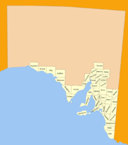
Adelaide
Adelaide is the capital city of South Australia and the fifth-largest city in Australia. Adelaide has an estimated population of more than 1.2 million...
is located in the Hundred of Adelaide
Hundred of Adelaide
The Hundred of Adelaide is the cadastral unit of hundred for the city of Adelaide. It is one of the eleven hundreds of the County of Adelaide, and was one of the first hundreds to be proclaimed. Like the surrounding city, the hundred was named after Queen Adelaide. It was named by Governor...
in the County of Adelaide. The County of Adelaide between 1855 and 1921 held at least 60% of South Australia's population; the figure rose to 70.6% in 1966. All of the counties had been proclaimed by 1900, except for Le Hunte (proclaimed 1908), Bosanquet (proclaimed 1913), and Hore-Ruthven (proclaimed 1933).
Parcels of land in most residential areas are identified with the Deposited Plan or Filed Plan number with an allotment number, for example "Allotment 20 in Deposited Plan
(DP) 11270". In many rural areas and historically in residential areas, land is described with the Section number, Hundred and County, for example "Section 53, Hundred of Borda, County of Carnarvon", or the allotment number within government towns. Sometimes a combination is used, such as "allotment 1 (DP 25326), Hundred of Munno Para" Often only the Hundred name is used, not the County, as each Hundred has a unique name making the county name redundant.
Tasmania
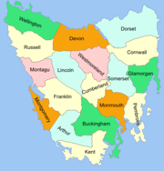
Flinders Island
Flinders Island may refer to:In Australia:* Flinders Island , in the Furneaux Group, is the largest and best known* Flinders Island * Flinders Island , in the Investigator Group* Flinders Island...
and King Island are now also districts. In the nineteenth and early twentieth century Tasmania had 18 counties. The original counties were divide into hundreds (containing four parishes) but this distinction was seldom observed
. Legal documents list Lot numbers, Plan numbers, Parishes and Land Districts. For example "Lot No. 2 on Plan No. P.14486, Parish of Sorell, Land District of Pembroke
Pembroke Land District, Tasmania
Pembroke Land District is one of the twenty land districts of Tasmania which are part of the Cadastral divisions of Tasmania. It was formerly one of the 18 counties of Tasmania. It includes Tasman Peninsula and Port Arthur, as well as Forestier Peninsula, Dodges Ferry and Maria Island...
"
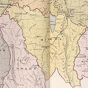
Victoria
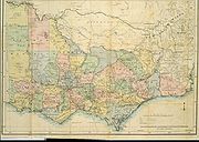
The counties of Victoria were gazetted in stages between 1849 and 1871. There are 37 counties, roughly 40 x 40 miles in size, which are further divided into 2914 parishes. The parishes were subdivided into sections of various sizes for sale as farming allotments, or designated as a town and then divided into sections and these subdivided into crown allotments. However many parishes in Victoria do not follow the county borders, some being located in more than one county, unlike in New South Wales. The county with the largest population is the County of Bourke, which contains Melbourne
Melbourne
Melbourne is the capital and most populous city in the state of Victoria, and the second most populous city in Australia. The Melbourne City Centre is the hub of the greater metropolitan area and the Census statistical division—of which "Melbourne" is the common name. As of June 2009, the greater...
. Legal documents can describe the County, Parish, Township (if there is one), Section, Crown Allotment number, and Certified Plan number. For example: "County of Dalhousie
County of Dalhousie
The County of Dalhousie is one of the 37 counties of Victoria which are part of the cadastral divisions of Australia, used for land titles. It is located to the north of Melbourne. It is bounded by the Coliban River to the west. The Goulburn River forms part of the boundary to the north-east...
, Parish of Lauriston, being 2 hectares, being Crown Allotment 2, Section 40" or
"Parish of Ballarat, County of Grant.. Crown Allotment 29, Section 101, Township of Ballarat East.. as shown on Certified Plan No. 105127"
Western Australia
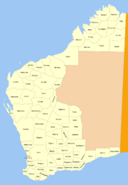
Perth, Western Australia
Perth is the capital and largest city of the Australian state of Western Australia and the fourth most populous city in Australia. The Perth metropolitan area has an estimated population of almost 1,700,000....
. The counties were designated in 1829, the year of the foundation of the Swan River Colony
Swan River Colony
The Swan River Colony was a British settlement established in 1829 on the Swan River, in Western Australia. The name was a pars pro toto for Western Australia. In 1832, the colony was officially renamed Western Australia, when the colony's founding Lieutenant-Governor, Captain James Stirling,...
, with Governor Stirling
James Stirling (Australian governor)
Admiral Sir James Stirling RN was a British naval officer and colonial administrator. His enthusiasm and persistence persuaded the British Government to establish the Swan River Colony and he became the first Governor and Commander-in-Chief of Western Australia...
instructing that counties were to be approximately 40 miles square (1600 square miles). The counties appear on some nineteenth century maps of Australia along with counties in other states, however it was the land districts which were used for cadastral purposes, and were the equivalent of the counties used in the eastern states. Around the end of the twentieth century, legal documents usually wrote them in the order: Land District, Location, number. For example: "Swan
Swan Land District
Swan Land District is one of the land districts of Western Australia, which is located within the South West Division. It covers all of the northern and eastern suburbs of Perth, as well as some inner southern areas such as Belmont and Applecross and the area to the north up to the Moore River,...
Location 2301". These are further divided into lots. More recently, Western Australia uses only the Lot and Deposited Plan numbers, such as "Lot 853 on Deposited Plan 222626".