

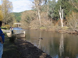
Ovens River
Encyclopedia
Australia
Australia , officially the Commonwealth of Australia, is a country in the Southern Hemisphere comprising the mainland of the Australian continent, the island of Tasmania, and numerous smaller islands in the Indian and Pacific Oceans. It is the world's sixth-largest country by total area...
n state of Victoria
Victoria (Australia)
Victoria is the second most populous state in Australia. Geographically the smallest mainland state, Victoria is bordered by New South Wales, South Australia, and Tasmania on Boundary Islet to the north, west and south respectively....
.
Hamilton Hume and William Hovell explored
Hume and Hovell expedition
The Hume and Hovell expedition was one of the most important journeys of explorations undertaken in eastern Australia. In 1824 the Governor of New South Wales, Sir Thomas Brisbane, commissioned Hamilton Hume and former Royal Navy Captain William Hovell to lead an expedition to find new grazing land...
the area in 1824, naming the Ovens River. The river was called Burwang by the local Aborigines
Australian Aborigines
Australian Aborigines , also called Aboriginal Australians, from the latin ab originem , are people who are indigenous to most of the Australian continentthat is, to mainland Australia and the island of Tasmania...
.
The river rises in the Victorian Alps and flows past Bright
Bright, Victoria
Bright is a small sized town, located in northeastern Victoria, Australia, 319 metres above sea level at the southeastern end of the Ovens Valley. At the 2006 census, Bright had a population of 2684. It is in the Alpine Shire local government area...
, Myrtleford
Myrtleford, Victoria
Myrtleford is a town in north-east Victoria, Australia, 45 km south-east of Wangaratta and 275 km north-east of Melbourne. Myrtleford is part of the Alpine Shire local government area and at the 2006 census the town had a population of 3,187....
and Wangaratta
Wangaratta, Victoria
Wangaratta is a cathedral city of almost 17,000 people in the northeast of Victoria, Australia, about from Melbourne along the Hume Highway, with Benalla to the southwest, and Albury-Wodonga to the northeast. It is located at the junction of the Ovens and King rivers which flow from the...
where it joins the King River.
Ovens Valley
The river flows through the Ovens Valley, which is a popular tourist destination servicing the ski fields of Mount HothamMount Hotham
Mount Hotham is a mountain in Victoria, Australia. It is home to Hotham Alpine Resort. The mountain is located approximately north east of Melbourne, from Sydney, and from Adelaide by road. Mt Hotham's summit rises to an altitude of above sea level...
, Mount Buffalo and Falls Creek
Falls Creek, Victoria
Falls Creek is a ski-in, ski-out ski resort in north-eastern Victoria, Australia. It is located about 350 kilometres by road from Melbourne in the Alpine National Park, with the nearest town Mount Beauty, approximately 30 kilometres away. The resort lies between an altitude of 1,210 and 1,830...
, the Alpine National Park
Alpine National Park
The Alpine National Park is a national park in Victoria , northeast of Melbourne. It covers much of the higher areas of the Great Dividing Range in Victoria, including Victoria's highest point, Mount Bogong and the associated subalpine woodland and grassland of the Bogong High Plains...
and the Mount Buffalo National Park
Mount Buffalo National Park
Mount Buffalo is a mountain plateau in Victoria , 200 km northeast of Melbourne. It is one of the oldest parks in the Australian Alps, being first established in 1898 when 1165 ha was reserved around Eurobin Falls...
. Air sports such as gliding
Gliding
Gliding is a recreational activity and competitive air sport in which pilots fly unpowered aircraft known as gliders or sailplanes using naturally occurring currents of rising air in the atmosphere to remain airborne. The word soaring is also used for the sport.Gliding as a sport began in the 1920s...
and paragliding
Paragliding
Paragliding is the recreational and competitive adventure sport of flying paragliders: lightweight, free-flying, foot-launched glider aircraft with no rigid primary structure...
are also practised here, and there is a hedge maze
Maze
A maze is a tour puzzle in the form of a complex branching passage through which the solver must find a route. In everyday speech, both maze and labyrinth denote a complex and confusing series of pathways, but technically the maze is distinguished from the labyrinth, as the labyrinth has a single...
at Wandiligong
Wandiligong, Victoria
Wandiligong is a town in north-eastern Victoria, Australia. The town is located on Morses Creek and in the Alpine Shire local government area, south of Bright and north east of the state capital, Melbourne. At the 2006 census, Wandiligong had a population of 281.Wandiliong was established in the...
. An abandoned railway line has been converted to a cycle
Bicycle
A bicycle, also known as a bike, pushbike or cycle, is a human-powered, pedal-driven, single-track vehicle, having two wheels attached to a frame, one behind the other. A person who rides a bicycle is called a cyclist, or bicyclist....
trail, known as a rail trail
Rail trail
A rail trail is the conversion of a disused railway easement into a multi-use path, typically for walking, cycling and sometimes horse riding. The characteristics of former tracks—flat, long, frequently running through historical areas—are appealing for various development. The term sometimes also...
, which stretches from Wangaratta and Beechworth
Beechworth, Victoria
Beechworth is a well-preserved historical town located in the north-east of Victoria, Australia, famous for its major growth during the gold rush days of the mid-1850s...
to Bright
Bright, Victoria
Bright is a small sized town, located in northeastern Victoria, Australia, 319 metres above sea level at the southeastern end of the Ovens Valley. At the 2006 census, Bright had a population of 2684. It is in the Alpine Shire local government area...
.
There are several wineries
Winery
A winery is a building or property that produces wine, or a business involved in the production of wine, such as a wine company. Some wine companies own many wineries. Besides wine making equipment, larger wineries may also feature warehouses, bottling lines, laboratories, and large expanses of...
in the area, and many hops
Hops
Hops are the female flower clusters , of a hop species, Humulus lupulus. They are used primarily as a flavoring and stability agent in beer, to which they impart a bitter, tangy flavor, though hops are also used for various purposes in other beverages and herbal medicine...
fields. The wineries are a popular stop for cyclists on their touring rides.
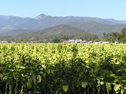
Tobacco was a major industry in the valley until 2006; that year saw the British American Tobacco
British American Tobacco
British American Tobacco p.l.c. is a global tobacco company headquartered in London, United Kingdom. It is the world’s second largest quoted tobacco company by global market share , with a leading position in more than 50 countries and a presence in more than 180 countries...
and Philip Morris
Altria Group
Altria Group, Inc. is based in Henrico County, Virginia, and is the parent company of Philip Morris USA, John Middleton, Inc., U.S. Smokeless Tobacco Company, Inc., Philip Morris Capital Corporation, and Chateau Ste. Michelle Wine Estates. It is one of the world's largest tobacco corporations...
companies decide to no longer buy Australian tobacco, and the Federal Government began implementing a plan to transition growers out of this industry. Reminders of the valley's long and prosperous tobacco history continue to dot the valley, such as the many drying huts
Tobacco barn
The tobacco barn, a type of functionally classified barn found in the United States, was once an essential ingredient in the process of air-curing tobacco. In the 21st century they are fast disappearing from the American landscape in places where they were once ubiquitous. The barns have declined...
.
List of Towns
- WangarattaWangaratta, VictoriaWangaratta is a cathedral city of almost 17,000 people in the northeast of Victoria, Australia, about from Melbourne along the Hume Highway, with Benalla to the southwest, and Albury-Wodonga to the northeast. It is located at the junction of the Ovens and King rivers which flow from the...
- BeechworthBeechworth, VictoriaBeechworth is a well-preserved historical town located in the north-east of Victoria, Australia, famous for its major growth during the gold rush days of the mid-1850s...
- EvertonEverton, VictoriaEverton is a small town located from Wangaratta in northeast Victoria, along the Great Alpine Road. At the 2006 census, Everton and the surrounding area had a population of 274....
- MyrtlefordMyrtleford, VictoriaMyrtleford is a town in north-east Victoria, Australia, 45 km south-east of Wangaratta and 275 km north-east of Melbourne. Myrtleford is part of the Alpine Shire local government area and at the 2006 census the town had a population of 3,187....
- OvensOvens, VictoriaOvens is a small town in north east Victoria, Australia located at the junction of the Ovens River and Happy Valley Creek. At the 2006 census, Ovens and the surrounding area had a population of 130. It is south east of Myrtleford heading towards Bright and is the home of the Happy Valley Hotel...
- BrightBright, VictoriaBright is a small sized town, located in northeastern Victoria, Australia, 319 metres above sea level at the southeastern end of the Ovens Valley. At the 2006 census, Bright had a population of 2684. It is in the Alpine Shire local government area...
- WandiligongWandiligong, VictoriaWandiligong is a town in north-eastern Victoria, Australia. The town is located on Morses Creek and in the Alpine Shire local government area, south of Bright and north east of the state capital, Melbourne. At the 2006 census, Wandiligong had a population of 281.Wandiliong was established in the...
- Harrietville
- PorepunkahPorepunkah, VictoriaPorepunkah is a town in north east Victoria, Australia. The town is located on the Great Alpine Road, at the foot of Mount Buffalo north east of the state capital, Melbourne and north west of Bright. Part of Alpine Shire Local government area and situated on the banks of the Ovens River, near the...