
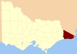
County of Croajingolong
Encyclopedia
Counties of Victoria
The Australian state of Victoria is divided into 37 counties. They are part of the lands administrative divisions of Australia. These counties were gazetted in stages between 1849 and 1871 as Victoria was progressively opened up to European settlement. By 1890 all parish boundaries had been gazetted...
which are part of the cadastral divisions of Australia
Cadastral divisions of Australia
Lands administrative divisions of Australia refers to the parts of Australia which are divided into the cadastral units of counties, parishes, hundreds, and other divisions for the purposes of land ownership...
, used for land titles. It is the most easterly county, and includes the Croajingolong National Park
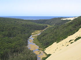
Croajingolong National Park
Croajingolong is a coastal national park in Victoria, Australia, 427 kilometres east of Melbourne.The name is thought to derive from the aboriginal word Krowathunkooloong, the name of the tribe inhabiting that area of Victoria.-Description:...
. Its western boundary is the Snowy River
Snowy River
The Snowy River is a major river in south-eastern Australia. It originates on the slopes of Mount Kosciuszko, Australia's highest mainland peak, draining the eastern slopes of the Snowy Mountains in New South Wales, before flowing through the Snowy River National Park in Victoria and emptying into...
. The county was proclaimed in 1871 together with others from the Gipps Land District. Some time earlier maps showed proposed counties of Howe and Combermere occupying the area of Croajingolong.
Parishes
Parishes include:- Baawang, Victoria
- Barga, Victoria
- Bemm, Victoria
- Bendock, Victoria
- Betka, Victoria
- Bidwell, Victoria
- Bonang, Victoria
- Bondi, Victoria
- Boorpuk, Victoria
- Bralak, Victoria
- Brindat, Victoria
- Bullamalk, Victoria
- Bungywarr, Victoria
- Cabanandra, Victoria
- Cobon, Victoria
- Combienbar, Victoria
- Cooaggalah, Victoria
- Coopracambra, Victoria
- Curlip, Victoria
- Deddick, Victoria
- Dellicknora, Victoria
- Derndang, Victoria
- Errinundra, Victoria
- Gabo, Victoria
- Goolengook, Victoria
- Goongerah, Victoria
- Jilwain, Victoria
- Jingallala, Victoria
- Jirrah, Victoria
- Karlo, Victoria
- Kirkenong, Victoria
- Koola, Victoria
- Kooragan, Victoria
- Kowat, Victoria
- Kuark, Victoria
- Loomat, Victoria
- Loongelaat, Victoria
- Mallacoota, VictoriaMallacoota, Victoria-External links:***...
- Maramingo, Victoria
- Moonkan, Victoria
- Murrungowar, Victoria
- Nerran, Victoria
- Noonga, Victoria
- Noorinbee, Victoria
- Nungal, Victoria
- Orbost, VictoriaOrbost, VictoriaOrbost is a town in the Shire of East Gippsland, Victoria, Australia, located east of Melbourne and south of Canberra where the Princes Highway crosses the Snowy River. It is about from the town of Marlo on the coast of Bass Strait. At the 2006 census, Orbost had a population of 2452...
- Orbost East, Victoria
- Pinnak, Victoria
- Purgagoolah, Victoria
- Tabbara, Victoria
- Tamboon, Victoria
- Thurra, Victoria
- Tingaringy, Victoria
- Tonghi, Victoria
- Toonyarak, Victoria
- Tubbut, Victoria
- Wangarabell, Victoria
- Wat Wat, Victoria
- Wau Wauka, Victoria
- Wau Wauka West, Victoria
- Weeragua, Victoria
- Wibenduck, Victoria
- Wingan, Victoria
- Winyar, Victoria
- Wooyoot, Victoria
- Wurrin, Victoria
- Wyangil, Victoria
- Yalmy, Victoria
- Yarak, Victoria