
Cowley County, New South Wales
Encyclopedia

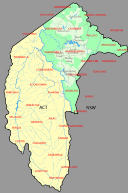
Cadastral divisions of New South Wales
Lands administrative divisions of New South Wales refers to the 141 counties within the Australian state of New South Wales, which are further subdivided into 7,459 parishes. There are also three Land Divisions, around 100 Land Districts, and several other types of districts as well as land boards...
. It contains the locality of Cavan
Cavan, New South Wales
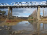
Cavan is a rural community situated on south bank of Murrumbidgee River in the eastern part of the Riverina. It is situated by road, about 22 kilometres north from Wee Jasper and 26 kilometres south from Yass....
. It was originally bordered on the north, east and part of the south by the Murrumbidgee River
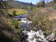
Murrumbidgee River
The Murrumbidgee River is a major river in the state of New South Wales, Australia, and the Australian Capital Territory . A major tributary of the Murray River, the Murrumbidgee flows in a west-northwesterly direction from the foot of Peppercorn Hill in the Fiery Range of the Snowy Mountains,...
, and on the west by the Goodradigbee River
Goodradigbee River
The Goodradigbee River is in south-eastern New South Wales, Australia. It flows into Burrinjuck Dam and thus is a tributary of the Murrumbidgee River....
. A large part of the county was transferred to the Commonwealth to make the Australian Capital Territory
Australian Capital Territory
The Australian Capital Territory, often abbreviated ACT, is the capital territory of the Commonwealth of Australia and is the smallest self-governing internal territory...
in 1909, with the remaining part the area to the north-west of the ACT as far north as the Burrinjuck Dam
Burrinjuck Dam
Burrinjuck Dam is a high, concrete gravity dam on the Murrumbidgee River approximately 60 km from Yass, New South Wales, Australia. The Yass and Goodradigbee Rivers flow into the dam. The dam divides the upper and lower catchment of the Murrumbidgee and is the headwater storage for the...
, and thin strips of land along the western, southern and south-eastern borders of the ACT.
Cowley County is named in honour of Henry Richard Charles Wellesley
Henry Wellesley, 1st Earl Cowley
Henry Richard Charles Wellesley, 1st Earl Cowley KG GCB PC , known as The Lord Cowley between 1847 and 1857, was a British diplomat...
, First Earl Cowley (1804-1884).
Parishes within this county
A full list of parishes found within this county including the 15 former parishes which are now part of the ACT; their current LGA and mapping coordinates to the approximate centre of each location is as follows:| Parish | LGA | Coordinates |
|---|---|---|
| Bimberi | Tumut Shire Council Tumut Shire Council Tumut Shire is a local government area in New South Wales, Australia. It includes the town of Tumut and the small towns of Gilmore, Adelong, Grahamstown, Gocup, Brungle, Talbingo, Wondalga, Batlow, Killimicat and Cabramurra.-References:... |
35°34′54"S 148°45′04"E |
| Boboyan (former) | Australian Capital Territory Australian Capital Territory The Australian Capital Territory, often abbreviated ACT, is the capital territory of the Commonwealth of Australia and is the smallest self-governing internal territory... |
|
| Booroomba (former) | Australian Capital Territory Australian Capital Territory The Australian Capital Territory, often abbreviated ACT, is the capital territory of the Commonwealth of Australia and is the smallest self-governing internal territory... |
|
| Brayshaw (former) | Australian Capital Territory Australian Capital Territory The Australian Capital Territory, often abbreviated ACT, is the capital territory of the Commonwealth of Australia and is the smallest self-governing internal territory... |
|
| Brindibella Brindabella, New South Wales Brindabella is a locality in south east New South Wales, Australia, in the area of Yass Valley Council. It is reached by the Brindabella Road from the Australian Capital Territory over the Brindabella Ranges... |
Tumut Shire Council Tumut Shire Council Tumut Shire is a local government area in New South Wales, Australia. It includes the town of Tumut and the small towns of Gilmore, Adelong, Grahamstown, Gocup, Brungle, Talbingo, Wondalga, Batlow, Killimicat and Cabramurra.-References:... |
35°23′54"S 148°46′04"E |
| Bumbalong | Cooma-Monaro Shire | 35°48′54"S 149°07′04"E |
| Cavan Cavan, New South Wales Cavan is a rural community situated on south bank of Murrumbidgee River in the eastern part of the Riverina. It is situated by road, about 22 kilometres north from Wee Jasper and 26 kilometres south from Yass.... |
Yass Valley Council | 35°03′54"S 148°52′04"E |
| Cochran | Cooma-Monaro Shire | 35°44′54"S 148°53′04"E |
| Congwarra (former) | Australian Capital Territory Australian Capital Territory The Australian Capital Territory, often abbreviated ACT, is the capital territory of the Commonwealth of Australia and is the smallest self-governing internal territory... |
|
| Cooleman | Tumut Shire Council Tumut Shire Council Tumut Shire is a local government area in New South Wales, Australia. It includes the town of Tumut and the small towns of Gilmore, Adelong, Grahamstown, Gocup, Brungle, Talbingo, Wondalga, Batlow, Killimicat and Cabramurra.-References:... |
35°39′54"S 148°45′04"E |
| Coree Coree, New South Wales Coree is a community in the central part of the Riverina in New South Wales, Australia. It is situated about 43 kilometres west from Jerilderie and 48 kilometres east from Conargo. At the 2006 census, Coree had a population of 91 people... |
Yass Valley Council | 35°16′54"S 148°46′04"E |
| Cotter (former) | Australian Capital Territory Australian Capital Territory The Australian Capital Territory, often abbreviated ACT, is the capital territory of the Commonwealth of Australia and is the smallest self-governing internal territory... |
|
| Cuppacumbalong | Cooma-Monaro Shire | 35°36′54"S 149°06′04"E |
| East Goodradigbee | Yass Valley Council | 35°07′54"S 148°44′04"E |
| Fergus (former) | Australian Capital Territory Australian Capital Territory The Australian Capital Territory, often abbreviated ACT, is the capital territory of the Commonwealth of Australia and is the smallest self-governing internal territory... |
|
| Gibraltar (former) | Australian Capital Territory Australian Capital Territory The Australian Capital Territory, often abbreviated ACT, is the capital territory of the Commonwealth of Australia and is the smallest self-governing internal territory... |
|
| Greenfield (former) | Australian Capital Territory Australian Capital Territory The Australian Capital Territory, often abbreviated ACT, is the capital territory of the Commonwealth of Australia and is the smallest self-governing internal territory... |
|
| Gudgenby (former) | Australian Capital Territory Australian Capital Territory The Australian Capital Territory, often abbreviated ACT, is the capital territory of the Commonwealth of Australia and is the smallest self-governing internal territory... |
|
| Gurrangora | Cooma-Monaro Shire | 35°44′54"S 148°45′04"E |
| Long Plain | Cooma-Monaro Shire | 35°39′54"S 148°37′04"E |
| Micalong | Yass Valley Council | 35°13′54"S 148°45′04"E |
| Milligan (former) | Australian Capital Territory Australian Capital Territory The Australian Capital Territory, often abbreviated ACT, is the capital territory of the Commonwealth of Australia and is the smallest self-governing internal territory... |
|
| Mullion | Yass Valley Council | 35°07′54"S 148°48′04"E |
| Murray | Tumut Shire Council Tumut Shire Council Tumut Shire is a local government area in New South Wales, Australia. It includes the town of Tumut and the small towns of Gilmore, Adelong, Grahamstown, Gocup, Brungle, Talbingo, Wondalga, Batlow, Killimicat and Cabramurra.-References:... |
35°36′54"S 148°40′04"E |
| Naas (former) | Australian Capital Territory Australian Capital Territory The Australian Capital Territory, often abbreviated ACT, is the capital territory of the Commonwealth of Australia and is the smallest self-governing internal territory... |
|
| Narrangullen | Yass Valley Council | 34°59′54"S 148°43′04"E |
| Nattung | Cooma-Monaro Shire | 35°44′54"S 148°36′04"E |
| Orroral (former) | Australian Capital Territory Australian Capital Territory The Australian Capital Territory, often abbreviated ACT, is the capital territory of the Commonwealth of Australia and is the smallest self-governing internal territory... |
|
| Pabral | Yass Valley Council | 35°13′54"S 148°48′04"E |
| Punyibah (former) | Australian Capital Territory Australian Capital Territory The Australian Capital Territory, often abbreviated ACT, is the capital territory of the Commonwealth of Australia and is the smallest self-governing internal territory... |
|
| Taemas | Yass Valley Council | 35°01′54"S 148°46′04"E |
| Tharwa (former) | Australian Capital Territory Australian Capital Territory The Australian Capital Territory, often abbreviated ACT, is the capital territory of the Commonwealth of Australia and is the smallest self-governing internal territory... |
|
| Tidbinbilla (former) | Australian Capital Territory Australian Capital Territory The Australian Capital Territory, often abbreviated ACT, is the capital territory of the Commonwealth of Australia and is the smallest self-governing internal territory... |
|
| Umburra | Yass Valley Council | 35°08′54"S 148°53′04"E |
| Urayarra | Yass Valley Council | 35°14′54"S 148°53′04"E |
| Venterman | Tumut Shire Council Tumut Shire Council Tumut Shire is a local government area in New South Wales, Australia. It includes the town of Tumut and the small towns of Gilmore, Adelong, Grahamstown, Gocup, Brungle, Talbingo, Wondalga, Batlow, Killimicat and Cabramurra.-References:... |
35°29′54"S 148°45′04"E |
| Yaouk | Cooma-Monaro Shire | 35°44′54"S 148°48′04"E |
| Yarara | Cooma-Monaro Shire | 35°44′54"S 149°06′04"E |