
Pembroke Land District, Tasmania
Encyclopedia
Tasmania
Tasmania is an Australian island and state. It is south of the continent, separated by Bass Strait. The state includes the island of Tasmania—the 26th largest island in the world—and the surrounding islands. The state has a population of 507,626 , of whom almost half reside in the greater Hobart...
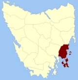
which are part of the Cadastral divisions of Tasmania
Cadastral divisions of Tasmania
The Lands administrative divisions of Tasmania refer to the division of Tasmania into land districts and parishes for cadastral purposes, which are part of the lands administrative divisions of Australia...
. It was formerly one of the 18 counties of Tasmania. It includes Tasman Peninsula
Tasman Peninsula
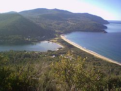
Tasman Peninsula is located around by road south-east of Hobart, at the south east corner of Tasmania, Australia.-Description:The Tasman Peninsula lies south and west of Forestier Peninsula, to which it is connected by an isthmus called Eaglehawk Neck...
and Port Arthur
Port Arthur, Tasmania
Port Arthur is a small town and former convict settlement on the Tasman Peninsula, in Tasmania, Australia. Port Arthur is one of Australia's most significant heritage areas and the open air museum is officially Tasmania's top tourist attraction. It is located approximately 60 km south east of...
, as well as Forestier Peninsula
Forestier Peninsula
The Forestier Peninsula is a peninsula of the Australian island state of Tasmania. Its coordinates are . It is connected to the mainland at East Bay Neck, near the town of Dunalley...
, Dodges Ferry
Dodges Ferry, Tasmania
Dodges Ferry is a small township on the eastern side of the entrance to Pittwater in south eastern Tasmania, Australia. It was named after Ralph Dodge who operated a ferry service across Pittwater from the 1820s. It is now a popular tourist locale. At the 2006 census, Dodges Ferry had a...
and Maria Island
Maria Island
Maria Island is a mountainous island off the east coast of Tasmania. The entire island is a national park. Maria Island National Park has a total area of 115.50 km², which includes a marine area of 18.78 km² off the island's northwest coast. The island is about 20 km in length from...
. The Electoral division of Pembroke
Electoral division of Pembroke
The Electoral Division of Pembroke is one of the 15 electorates or 'seats' in the Tasmanian Legislative Council or upper house. It is located on Hobart's Eastern Shore and includes a number of suburbs; Risdon Vale, Geilston Bay, Rose Bay, Lindisfarne, Warrane, Mornington, Bellerive, Howrah and...
is not actually within the land district, but is close by in Monmouth
Monmouth Land District, Tasmania
Monmouth Land District is one of the twenty land districts of Tasmania which are part of the Cadastral divisions of Tasmania. It was formerly one of the 18 counties of Tasmania...
.
The original parishes
On 15 January 1836 George Arthur, the Lieutenant Governor of the Island of Van Diemen's LandVan Diemen's Land
Van Diemen's Land was the original name used by most Europeans for the island of Tasmania, now part of Australia. The Dutch explorer Abel Tasman was the first European to land on the shores of Tasmania...
proclaimed, via The Hobart Town Courier
The Courier (Hobart)
The Courier is a newspaper founded in 1827 in Hobart, Tasmania, as the Hobart Town Courier. It changed names to the Hobart Town Courier and Van Diemen's Land Advertiser in 1839, settling on The Courier in 1840. In 1859 it merged with The Hobart Town Daily Mercury.-References:* from the Mercury...
, the first counties and parishes to be surveyed in the colony.
The County of Pembroke, bounded on the north by Little Swan port river; on the east by the Pacific ocean; on the south by Storm bay, and on the west by Storm bay, Norfolk bay, Pittwater, and by the eastern boundaries of the parishes of Ulva, Staffa and Ormaig, and a line to the south east angle of the county of Somerset. This county to include the White Tock, Maria island, Lachlan island, the Hippolyte rocks, Tasman's island, Wedge island, Sloping island, Garden island, Low island, the islands in Pittwater, and all other islands adjacent to the coasts of the county.
Hundreds and parishes proclaimed at this time were:
- The hundred of Sorell
- Canning parish
- Forcett
- Carlton
- Sorell
The township of Sorell
Sorell, Tasmania
Sorell is a town in Tasmania, Australia, north-east of Hobart. It is on the Tasman Highway which continues up the east coast of Tasmania. At the 2006 census, Sorell had a population of 1,546....
was proclaimed as being within the county.