
Cumberland County, New South Wales
Encyclopedia
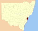
Cumberland County is a county
in the State
of New South Wales
, Australia
. Most of the Sydney
metropolitan area
is located within the County of Cumberland.
The County of Cumberland stretches from Broken Bay
to the north, the Hawkesbury River
to the north-west, the Nepean River
to the west, the Cataract River
to the south-west and the northern suburbs of Wollongong
to the south. It includes the area of the Cumberland Plain
.
, Duke of Cumberland, later King of Hanover, at a gathering to celebrate the birthday of his father, King George III, on 4 June 1788. The county has been marked on maps since the start of the colony, as shown along the key on a 1789 map describing Port Jackson
as being within the county of Cumberland. In the nineteenth century, parts of the county were in the South
and North
Riding electoral districts from 1856 to 1859, which were replaced by Central Cumberland
. There was also the Cumberland Boroughs
electoral district.
and the registration of land titles. Few Australian counties have ever had any government or administrative function. However, the County of Cumberland did have a county government, the Cumberland County Council, from 1945 to 1964. Its responsibilities were primarily limited to town planning on the metropolitan scale. The Cumberland County Council was not elected by the people, but rather was elected by councillors of the various local governments within the County. In 1951 the Council ratified the Cumberland County Council Planning Scheme which boldly reformed town planning throughout metropolitan Sydney. Though not all of the plan was implemented, much of it was, radically altering the urban form of Sydney and its suburbs.
The objectives of the County Council were often in conflict with the aims of many State Government
departments. For instance, the County Council's plans called for a green belt
to encircle metropolitan Sydney, while the NSW Housing Commission wished to use much of this land to build new low-density public housing
estates in areas such as Blacktown
and Liverpool
. As a result, the Cumberland County Council was dissolved in 1964.
Its metropolitan planning functions were taken over by a new body, the State Planning Authority, which has since been superseded by a succession of state government departments. As of 2008 this government department is the New South Wales Department of Planning.
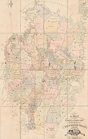 There were thirteen hundreds in Cumberland County, which were published in a government
gazette
on 27 May 1835, but repealed on 21 January 1888. Unlike South Australia
, the hundreds were never adopted anywhere else in New South Wales
. The hundreds:
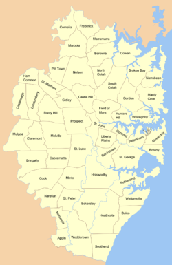 In 1835, Cumberland County was subdivided into 57 parishes. Previously, the subdivisions of the area since the beginning of the colony were called districts. Many of the parishes founded in 1835 kept the name of the district. Others were named after Anglican churches in the same area. This included three of the four small parishes in the Sydney city area; St Philip (named after St.Philip's), St James (named after St. James
, and which is still the region name today), St Andrew (named after St. Andrew's
). However St Lawrence parish gave its name to the church
, rather than the other way around. Further out of the city, the parishes of St John, St Luke, St Peter and St Matthew, in the Parramatta
, Liverpool
, Campbelltown
and Windsor
areas respectively, have Anglican churches which bear the same saints names; St John's in Parramatta (opened 1803); St.Luke's in Liverpool (building began 1818); St.Peter's in Campbelltown (opened 1823, the third oldest Anglican church in Australia); and St. Matthew's in Windsor (consecrated in 1822)
A full list of parishes found within this county; the LGA which the parish is mostly in (some are part of several LGAs), and mapping coordinates to the approximate centre of each location is as follows:
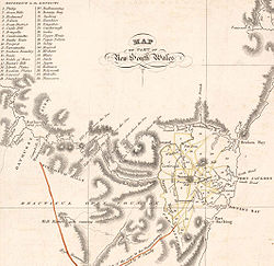 The first subdivisions of the county were called districts, shown in early maps from the period, such as 21 districts on an 1810 map and 37 districts on an 1824 map (not including Philip which was across the Nepean River
and not part of the county). The districts in use in 1824:
County
A county is a jurisdiction of local government in certain modern nations. Historically in mainland Europe, the original French term, comté, and its equivalents in other languages denoted a jurisdiction under the sovereignty of a count A county is a jurisdiction of local government in certain...
in the State
States and territories of Australia
The Commonwealth of Australia is a union of six states and various territories. The Australian mainland is made up of five states and three territories, with the sixth state of Tasmania being made up of islands. In addition there are six island territories, known as external territories, and a...
of New South Wales
New South Wales
New South Wales is a state of :Australia, located in the east of the country. It is bordered by Queensland, Victoria and South Australia to the north, south and west respectively. To the east, the state is bordered by the Tasman Sea, which forms part of the Pacific Ocean. New South Wales...
, Australia
Australia
Australia , officially the Commonwealth of Australia, is a country in the Southern Hemisphere comprising the mainland of the Australian continent, the island of Tasmania, and numerous smaller islands in the Indian and Pacific Oceans. It is the world's sixth-largest country by total area...
. Most of the Sydney
Sydney
Sydney is the most populous city in Australia and the state capital of New South Wales. Sydney is located on Australia's south-east coast of the Tasman Sea. As of June 2010, the greater metropolitan area had an approximate population of 4.6 million people...
metropolitan area
Metropolitan area
The term metropolitan area refers to a region consisting of a densely populated urban core and its less-populated surrounding territories, sharing industry, infrastructure, and housing. A metropolitan area usually encompasses multiple jurisdictions and municipalities: neighborhoods, townships,...
is located within the County of Cumberland.
The County of Cumberland stretches from Broken Bay
Broken Bay
Broken Bay is a large inlet of the Pacific Ocean located about 50 km north of Sydney on the coast of New South Wales, Australia, and is the first major bay north of Sydney's Port Jackson.- Geography :...
to the north, the Hawkesbury River
Hawkesbury River
The Hawkesbury River, also known as Deerubbun, is one of the major rivers of the coastal region of New South Wales, Australia. The Hawkesbury River and its tributaries virtually encircle the metropolitan region of Sydney.-Geography:-Course:...
to the north-west, the Nepean River
Nepean River
The Nepean River is a river in the coastal region of New South Wales, Australia.The headwaters of the Nepean River rise near Robertson, about 100 kilometres south of Sydney and about 15 kilometres from the coast. The river flows north in an unpopulated water catchment area into Nepean Dam, which...
to the west, the Cataract River
Cataract River (Wollondilly)
The Cataract River is a tributary of the Nepean River, and hence of the Hawkesbury River, in New South Wales, Australia. The headwaters of the river are in the Wollondilly Shire local government area....
to the south-west and the northern suburbs of Wollongong
Wollongong, New South Wales
Wollongong is a seaside city located in the Illawarra region of New South Wales, Australia. It lies on the narrow coastal strip between the Illawarra Escarpment and the Pacific Ocean, 82 kilometres south of Sydney...
to the south. It includes the area of the Cumberland Plain
Cumberland Plain
The Cumberland Plain is a region in the Sydney Basin of New South Wales, Australia. The plain extends from 10 kilometres north of Windsor in the north, to Picton in the south; and...
.
History
The name Cumberland was conferred by Governor Phillip in honour of Ernest AugustusErnest Augustus I of Hanover
Ernest Augustus I was King of Hanover from 20 June 1837 until his death. He was the fifth son and eighth child of George III, who reigned in both the United Kingdom and Hanover...
, Duke of Cumberland, later King of Hanover, at a gathering to celebrate the birthday of his father, King George III, on 4 June 1788. The county has been marked on maps since the start of the colony, as shown along the key on a 1789 map describing Port Jackson
Port Jackson
Port Jackson, containing Sydney Harbour, is the natural harbour of Sydney, Australia. It is known for its beauty, and in particular, as the location of the Sydney Opera House and Sydney Harbour Bridge...
as being within the county of Cumberland. In the nineteenth century, parts of the county were in the South
Electoral district of Cumberland (South Riding)
Cumberland was an electoral district of the Legislative Assembly in the Australian state of New South Wales from 1856 to 1859, in the rural part of Cumberland County, which includes Sydney...
and North
Electoral district of Cumberland (North Riding)
Cumberland was an electoral district of the Legislative Assembly in the Australian state of New South Wales from 1856 to 1859, in Cumberland County, which includes Sydney...
Riding electoral districts from 1856 to 1859, which were replaced by Central Cumberland
Electoral district of Central Cumberland
Central Cumberland was an electoral district of the Legislative Assembly in the Australian state of New South Wales from 1859 to 1894, in Cumberland County, which includes Sydney...
. There was also the Cumberland Boroughs
Electoral district of Cumberland Boroughs
Cumberland Boroughs was an electoral district of the Legislative Assembly in the Australian state of New South Wales from 1856 to 1859, consisting of the Cumberland County towns of Richmond, Windsor, and Liverpool, and Campbelltown, but not the surrounding rural areas, which were in Cumberland and...
electoral district.
Use
New South Wales is divided up into 141 counties, for the purposes of surveyingSurveying
See Also: Public Land Survey SystemSurveying or land surveying is the technique, profession, and science of accurately determining the terrestrial or three-dimensional position of points and the distances and angles between them...
and the registration of land titles. Few Australian counties have ever had any government or administrative function. However, the County of Cumberland did have a county government, the Cumberland County Council, from 1945 to 1964. Its responsibilities were primarily limited to town planning on the metropolitan scale. The Cumberland County Council was not elected by the people, but rather was elected by councillors of the various local governments within the County. In 1951 the Council ratified the Cumberland County Council Planning Scheme which boldly reformed town planning throughout metropolitan Sydney. Though not all of the plan was implemented, much of it was, radically altering the urban form of Sydney and its suburbs.
The objectives of the County Council were often in conflict with the aims of many State Government
Government of New South Wales
The form of the Government of New South Wales is prescribed in its Constitution, which dates from 1856, although it has been amended many times since then...
departments. For instance, the County Council's plans called for a green belt
Green belt
A green belt or greenbelt is a policy and land use designation used in land use planning to retain areas of largely undeveloped, wild, or agricultural land surrounding or neighbouring urban areas. Similar concepts are greenways or green wedges which have a linear character and may run through an...
to encircle metropolitan Sydney, while the NSW Housing Commission wished to use much of this land to build new low-density public housing
Public housing
Public housing is a form of housing tenure in which the property is owned by a government authority, which may be central or local. Social housing is an umbrella term referring to rental housing which may be owned and managed by the state, by non-profit organizations, or by a combination of the...
estates in areas such as Blacktown
Blacktown, New South Wales
Blacktown is a suburb in the City of Blacktown, in Western Sydney, in the state of New South Wales, Australia. Blacktown is located 34 kilometres west of the Sydney central business district and is the administrative centre of the local government area of City of Blacktown.Blacktown is the largest...
and Liverpool
Liverpool, New South Wales
Liverpool is a suburb in south-western Sydney, in the state of New South Wales, Australia. Liverpool is located 32 km south-west of the Sydney central business district, and is the administrative centre of the local government area of the City of Liverpool...
. As a result, the Cumberland County Council was dissolved in 1964.
Its metropolitan planning functions were taken over by a new body, the State Planning Authority, which has since been superseded by a succession of state government departments. As of 2008 this government department is the New South Wales Department of Planning.
Hundreds
Government
Government refers to the legislators, administrators, and arbitrators in the administrative bureaucracy who control a state at a given time, and to the system of government by which they are organized...
gazette
Gazette
A gazette is a public journal, a newspaper of record, or simply a newspaper.In English- and French-speaking countries, newspaper publishers have applied the name Gazette since the 17th century; today, numerous weekly and daily newspapers bear the name The Gazette.Gazette is a loanword from the...
on 27 May 1835, but repealed on 21 January 1888. Unlike South Australia
Cadastral divisions of South Australia
The Lands administrative divisions of South Australia refers to the cadastral units of counties, and hundreds in South Australia.These form part of the Lands administrative divisions of Australia. They are located in the south-eastern part of the state and do not cover the whole state...
, the hundreds were never adopted anywhere else in New South Wales
New South Wales
New South Wales is a state of :Australia, located in the east of the country. It is bordered by Queensland, Victoria and South Australia to the north, south and west respectively. To the east, the state is bordered by the Tasman Sea, which forms part of the Pacific Ocean. New South Wales...
. The hundreds:
- BringellyBringelly, New South WalesBringelly is a suburb of Sydney, in the state of New South Wales, Australia. It is located on the Northern Road between Penrith and Camden. It has a public school. Bringelly is also the name of a local hill.-History:...
- CampbelltownCampbelltown, New South WalesCampbelltown is a suburb in south-western Sydney, in the state of New South Wales, Australia. Campbelltown is located 51 kilometres south-west of the Sydney central business district and is the administrative centre for the local government area of the City of Campbelltown.- History :Campbelltown...
- DundasDundas, New South WalesDundas is a suburb of Sydney, in the state of New South Wales, Australia. Dundas is located 22 kilometres north-west of the Sydney central business district in the local government area of the City of Parramatta.-History:...
- Evan
- Hardinge
- LiverpoolLiverpool, New South WalesLiverpool is a suburb in south-western Sydney, in the state of New South Wales, Australia. Liverpool is located 32 km south-west of the Sydney central business district, and is the administrative centre of the local government area of the City of Liverpool...
- Packenham
- ParramattaParramatta, New South WalesParramatta is a suburb of Sydney, in the state of New South Wales, Australia. It is located in Greater Western Sydney west of the Sydney central business district on the banks of the Parramatta River. Parramatta is the administrative seat of the Local Government Area of the City of Parramatta...
- RichmondRichmond, New South WalesRichmond is a town in New South Wales, north-west of Sydney, in the Local Government Area of the City of Hawkesbury. It is located at a latitude of 33° 35' 54" South and a longitude of 150°45' 04" east, 19 metres above sea level on the alluvial Hawkesbury River flats, at the foot of the Blue...
- Southend
- Hundred of SydneyHundred of SydneyThe Hundred of Sydney is a former lands administrative division for the city of Sydney. It was one of the thirteen hundreds in the County of Cumberland, which were published in the government gazette of May 27, 1835, and repealed on January 21, 1888...
- WindsorWindsor, New South WalesWindsor is a town in the state of New South Wales, Australia. Windsor is located in the local government area of the City of Hawkesbury. It sits on the Hawkesbury River, on the north-western outskirts of the Sydney metropolitan area. At the 2006 census, Windsor had a population of...
- WoronoraWoronora, New South WalesWoronora is a suburb in southern Sydney, in the state of New South Wales, Australia. Woronora is located 27 kilometres south of the Sydney central business district, in the local government area of the Sutherland Shire. Woronora Heights is a separate suburb, to the south-west.-Placename...
(shown as HeathcoteHeathcote, New South WalesHeathcote is a suburb, in southern Sydney, in the state of New South Wales, Australia. Heathcote is located 36 km south of the Sydney central business district in the Sutherland Shire....
on some mapsMAPSMaps is the plural of map, a visual representation of an area.As an acronym, MAPS may refer to:* Mail Abuse Prevention System, an organisation that provides anti-spam support...
)
Parishes
St. James Church, Sydney
St James' Church is an Anglican church in King Street in Sydney, Australia. Consecrated on 11 February 1824, the church was designed by the transported convict architect Francis Greenway during the governorship of Lachlan Macquarie, and is part of the historical precinct of Macquarie Street...
, and which is still the region name today), St Andrew (named after St. Andrew's
St. Andrew's Cathedral, Sydney
St Andrew's Cathedral is the cathedral church of the Anglican Diocese of Sydney in the Anglican Church of Australia. The cathedral is the seat of the Anglican Archbishop of Sydney and Metropolitan of New South Wales, the Most Reverend Peter Jensen...
). However St Lawrence parish gave its name to the church
Christ Church St. Laurence
Christ Church St Laurence is an Anglican church in the Diocese of Sydney, Australia. The church is located at Railway Square on George Street, Sydney, near Central Station.-History and description:...
, rather than the other way around. Further out of the city, the parishes of St John, St Luke, St Peter and St Matthew, in the Parramatta
Parramatta, New South Wales
Parramatta is a suburb of Sydney, in the state of New South Wales, Australia. It is located in Greater Western Sydney west of the Sydney central business district on the banks of the Parramatta River. Parramatta is the administrative seat of the Local Government Area of the City of Parramatta...
, Liverpool
Liverpool, New South Wales
Liverpool is a suburb in south-western Sydney, in the state of New South Wales, Australia. Liverpool is located 32 km south-west of the Sydney central business district, and is the administrative centre of the local government area of the City of Liverpool...
, Campbelltown
Campbelltown, New South Wales
Campbelltown is a suburb in south-western Sydney, in the state of New South Wales, Australia. Campbelltown is located 51 kilometres south-west of the Sydney central business district and is the administrative centre for the local government area of the City of Campbelltown.- History :Campbelltown...
and Windsor
Windsor, New South Wales
Windsor is a town in the state of New South Wales, Australia. Windsor is located in the local government area of the City of Hawkesbury. It sits on the Hawkesbury River, on the north-western outskirts of the Sydney metropolitan area. At the 2006 census, Windsor had a population of...
areas respectively, have Anglican churches which bear the same saints names; St John's in Parramatta (opened 1803); St.Luke's in Liverpool (building began 1818); St.Peter's in Campbelltown (opened 1823, the third oldest Anglican church in Australia); and St. Matthew's in Windsor (consecrated in 1822)
A full list of parishes found within this county; the LGA which the parish is mostly in (some are part of several LGAs), and mapping coordinates to the approximate centre of each location is as follows:
| Parish | LGA | Hundred (former) | Coordinates |
|---|---|---|---|
| Alexandria Alexandria Parish, Cumberland Alexandria Parish is one of the 57 parishes of Cumberland County, New South Wales, a cadastral unit for use on land titles. It contains the area to the south and east of Sydney city including Bondi, Paddington and Clovelly.-References:*... |
Municipality of Woollahra Municipality of Woollahra The Municipality of Woollahra is a Local Government Area in the Eastern Suburbs of Sydney, in the state of New South Wales, Australia. The administrative centre of the Municipality of Woollahra is located on New South Head Road at Double Bay.... |
Sydney Hundred of Sydney The Hundred of Sydney is a former lands administrative division for the city of Sydney. It was one of the thirteen hundreds in the County of Cumberland, which were published in the government gazette of May 27, 1835, and repealed on January 21, 1888... |
33°50′54"S 151°17′04"E |
| Appin Appin Parish, Cumberland Appin Parish, Cumberland is one of the 57 parishes of Cumberland County, New South Wales, a cadastral unit for use on land titles. Its eastern boundary is the Georges River, and western boundary the Nepean River and Cataract River. It is centred on Appin.... |
Wollondilly Shire | Campbelltown | 34°11′54"S 150°45′04"E |
| Bankstown | City of Bankstown City of Bankstown The City of Bankstown is a city and Local Government Area in the Canterbury-Bankstown region of Sydney, New South Wales, Australia, centred on the suburb of Bankstown.... |
Liverpool | 33°55′54"S 150°59′04"E |
| Berowra | Hornsby Shire Hornsby Shire Hornsby Shire is a Local Government Area in the Northern region of Sydney, Australia. The Shire stretches from the suburb of Eastwood in the south to the Hawkesbury River town of Wisemans Ferry, some to the north... |
Dundas | 33°33′54"S 151°05′04"E |
| Botany Botany Parish, Cumberland Botany Parish, Cumberland is one of the 57 parishes of Cumberland County, New South Wales, a cadastral unit for use on land titles. It contains the area to the north of Botany Bay and to the east of part of Cooks River. It includes the suburbs of La Perouse, Hillsdale, Banksmeadow and Maroubra. It... |
City of Botany Bay City of Botany Bay The City of Botany Bay is a Local Government Area in south eastern Sydney, in the state of New South Wales, Australia. It encompasses the suburbs to the north of Botany Bay, such as Botany. The administrative centre is located at Mascot, which is 7 km south of the Sydney central business... |
Sydney Hundred of Sydney The Hundred of Sydney is a former lands administrative division for the city of Sydney. It was one of the thirteen hundreds in the County of Cumberland, which were published in the government gazette of May 27, 1835, and repealed on January 21, 1888... |
33°56′54"S 151°14′04"E |
| Bringelly | City of Penrith City of Penrith The City of Penrith is a Local Government Area in Sydney, located about west of Sydney's central business district.- History :The Municipality of Penrith was incorporated on 12 May 1871 under the Municipalities Act 1858. On 3 March 1890, St Marys was separately incorporated, and on 26 July 1893... |
Bringelly | 33°53′54"S 150°41′04"E |
| Broken Bay | Warringah Council Warringah Council Warringah is a local council area in the Northern Beaches region of Sydney, Australia. Warringah Council overlaps with a number of suburbs from the Manly Council area to the south and the Pittwater Council area to the north... |
Packenham | 33°38′54"S 151°13′04"E |
| Bulgo | City of Wollongong City of Wollongong The City of Wollongong is a Local Government Area in the Illawarra region of New South Wales, Australia. It is on the Pacific Ocean, the Southern Freeway and the South Coast railway line.... |
Heathcote | 34°09′54"S 151°03′04"E |
| Cabramatta | City of Liverpool | Bringelly | 33°54′54"S 150°49′04"E |
| Castle Hill | Baulkham Hills Shire Baulkham Hills Shire The Hills Shire is a local government area of in the north western region of Sydney, Australia. The area encompasses 380 square kilometres stretching from North Parramatta in the south to Wiseman's Ferry on the Hawkesbury River in the north.-Incomes:According to the Australian Bureau of... |
Parramatta | 33°44′54"S 150°41′04"E |
| Castlereagh | City of Penrith City of Penrith The City of Penrith is a Local Government Area in Sydney, located about west of Sydney's central business district.- History :The Municipality of Penrith was incorporated on 12 May 1871 under the Municipalities Act 1858. On 3 March 1890, St Marys was separately incorporated, and on 26 July 1893... |
Richmond | 33°40′54"S 150°42′04"E |
| Claremont | City of Penrith City of Penrith The City of Penrith is a Local Government Area in Sydney, located about west of Sydney's central business district.- History :The Municipality of Penrith was incorporated on 12 May 1871 under the Municipalities Act 1858. On 3 March 1890, St Marys was separately incorporated, and on 26 July 1893... |
Evan | 33°48′54"S 150°43′04"E |
| Concord Concord Parish, Cumberland Concord Parish is one of the 57 parishes of Cumberland County, New South Wales, a cadastral unit for use on land titles. It is located to the south of the Parramatta River between Homebush Bay and Iron Cove; and to the north of Cooks River. It includes the suburbs of Burwood, Croydon, Concord,... |
City of Canada Bay City of Canada Bay The City of Canada Bay is a Local Government Area of New South Wales, Australia and located in the metropolitan area of Sydney. The city was formed in December 2000, following the merger of Concord and Drummoyne councils... |
Sydney Hundred of Sydney The Hundred of Sydney is a former lands administrative division for the city of Sydney. It was one of the thirteen hundreds in the County of Cumberland, which were published in the government gazette of May 27, 1835, and repealed on January 21, 1888... |
33°51′54"S 151°06′04"E |
| Cook | Camden Council | Bringelly | 33°57′54"S 150°42′04"E |
| Cornelia | Baulkham Hills Shire Baulkham Hills Shire The Hills Shire is a local government area of in the north western region of Sydney, Australia. The area encompasses 380 square kilometres stretching from North Parramatta in the south to Wiseman's Ferry on the Hawkesbury River in the north.-Incomes:According to the Australian Bureau of... |
Hardinge | 32°59′54"S 150°00′04"E |
| Cowan | Hornsby Shire Hornsby Shire Hornsby Shire is a Local Government Area in the Northern region of Sydney, Australia. The Shire stretches from the suburb of Eastwood in the south to the Hawkesbury River town of Wisemans Ferry, some to the north... |
Dundas | 33°36′54"S 151°08′04"E |
| Eckersley | City of Campbelltown | Southend | 34°04′54"S 150°55′04"E |
| Field of Mars Field of Mars Parish, Cumberland Field of Mars Parish is one of the 57 parishes of Cumberland County, New South Wales, a cadastral unit for use on land titles. While the name is mostly forgotten as a region name today, it has given the name to the modern suburb of Marsfield and the reserve in the area. It is centred around... |
City of Parramatta City of Parramatta The City of Parramatta is a Local Government Area in western Sydney, in the state of New South Wales, Australia.Initially in 1861 it was formed as Municipality of Parramatta... |
Parramatta | 33°46′54"S 151°03′04"E |
| Frederick | Hornsby Shire Hornsby Shire Hornsby Shire is a Local Government Area in the Northern region of Sydney, Australia. The Shire stretches from the suburb of Eastwood in the south to the Hawkesbury River town of Wisemans Ferry, some to the north... |
Hardinge | 33°27′54"S 151°02′34"E |
| Gidley | City of Blacktown City of Blacktown The City of Blacktown is a Local Government Area in the heart of Western Sydney, situated on the Cumberland Plain, approximately 35 km from Sydney CBD. It is bounded by the Local Government Areas of Penrith, Parramatta, Fairfield, Holroyd, Hawkesbury and The Hills Shire. It occupies an area... |
Windsor | 33°40′54"S 150°52′04"E |
| Gordon | Ku-ring-gai Council Ku-ring-gai Council Ku-ring-gai Council is a Local Government Area in the North Shore region of Sydney. It includes the suburbs of Lindfield, Killara, Gordon, Pymble, St Ives, Turramurra, Warrawee, and parts of Roseville, and Wahroonga. The region is named after the Kuringgai tribe who once inhabited the area... |
Packenham | 33°12′54"S 151°09′04"E |
| Ham Common | City of Hawkesbury City of Hawkesbury The City of Hawkesbury is a Local Government Area of New South Wales, Australia, part of which is at the fringe of the Sydney metropolitan area, about 50 kilometres north-west of the Sydney central business district... |
Richmond | 33°35′54"S 150°45′04"E |
| Heathcote | Sutherland Shire Sutherland Shire The Sutherland Shire is a Local Government Area in the Southern Sydney region of Sydney, Australia. Geographically, it is the area to the south of Botany Bay and the Georges River... |
Heathcote | 34°05′54"S 150°59′04"E |
| Holsworthy | City of Liverpool | Liverpool | 33°56′54"S 150°57′04"E |
| Hunters Hill Hunters Hill Parish, Cumberland Hunters Hill Parish is one of the 57 parishes of Cumberland County, New South Wales, a cadastral unit for use on land titles. The suburb of Hunters Hill, and the Municipality of Hunter's Hill are in the same area.-References:*... |
City of Ryde City of Ryde The City of Ryde is a Local Government Area in Sydney, New South Wales, Australia, on the Lower North Shore and Greater Western Sydney over West Ryde and Eastwood District.... |
Parramatta | 33°47′54"S 151°06′04"E |
| Liberty Plains Liberty Plains Parish, Cumberland Liberty Plains Parish is one of the 57 parishes of Cumberland County, New South Wales, a cadastral unit for use on land titles. It is bounded by Parramatta Road in the north; the area between Flemington and Homebush, a small part of Cooks River and Liverpool Road in the east; the Hume Highway also... |
Strathfield Municipality | Parramatta | 33°51′54"S 151°02′04"E |
| Londonderry | City of Penrith City of Penrith The City of Penrith is a Local Government Area in Sydney, located about west of Sydney's central business district.- History :The Municipality of Penrith was incorporated on 12 May 1871 under the Municipalities Act 1858. On 3 March 1890, St Marys was separately incorporated, and on 26 July 1893... |
Richmond | 33°40′54"S 150°45′04"E |
| Manly Cove | Warringah Council Warringah Council Warringah is a local council area in the Northern Beaches region of Sydney, Australia. Warringah Council overlaps with a number of suburbs from the Manly Council area to the south and the Pittwater Council area to the north... |
Packenham | 33°46′54"S 151°16′04"E |
| Maroota | Baulkham Hills Shire Baulkham Hills Shire The Hills Shire is a local government area of in the north western region of Sydney, Australia. The area encompasses 380 square kilometres stretching from North Parramatta in the south to Wiseman's Ferry on the Hawkesbury River in the north.-Incomes:According to the Australian Bureau of... |
Hardinge | 33°29′54"S 151°00′04"E |
| Marramarra Marramarra Parish, Cumberland Marramarra Parish, Cumberland is one of the 57 parishes of Cumberland County, New South Wales, a cadastral unit for use on land titles.The first landholding in the Parish of Marramarra was of on the northern side of Marramarra Creek below Mount Blake. It was purchased by John Blake for One Pound... |
Hornsby Shire Hornsby Shire Hornsby Shire is a Local Government Area in the Northern region of Sydney, Australia. The Shire stretches from the suburb of Eastwood in the south to the Hawkesbury River town of Wisemans Ferry, some to the north... |
Dundas | 33°29′54"S 151°17′04"E |
| Melville | City of Fairfield City of Fairfield The City of Fairfield is a Local Government Area in the south-west of Sydney, in the state of New South Wales, Australia.- Suburbs in the local government area :Suburbs in the City of Fairfield are:* Abbotsbury* Bonnyrigg* Bonnyrigg Heights* Bossley Park... |
Evan | 33°51′16"S 150°49′20"E |
| Menangle | City of Campbelltown | Campbelltown | 34°06′54"S 150°47′04"E |
| Minto Minto Parish, Cumberland Minto Parish is one of the 57 parishes of Cumberland County, New South Wales, a cadastral unit for use on land titles. It includes Minto, Ingleburn, Glenfield and Macquarie Fields. Its eastern boundary is the Georges River, and western boundary was at the Great Southern Road.-References:*... |
City of Liverpool | Liverpool | 33°57′54"S 150°51′04"E |
| Mulgoa | City of Penrith City of Penrith The City of Penrith is a Local Government Area in Sydney, located about west of Sydney's central business district.- History :The Municipality of Penrith was incorporated on 12 May 1871 under the Municipalities Act 1858. On 3 March 1890, St Marys was separately incorporated, and on 26 July 1893... |
Evan | 33°48′54"S 150°40′04"E |
| Narellan | Camden Council | Campbelltown | 34°02′54"S 150°44′04"E |
| Narrabeen | Pittwater Council Pittwater Council Pittwater Council is a Local Government Area on the Northern Beaches of Sydney, in the state of New South Wales, Australia. The suburbs which comprise the Pittwater LGA were detached from the Warringah local government area in 1993... |
Packenham | 33°36′54"S 151°20′04"E |
| Nelson | Baulkham Hills Shire Baulkham Hills Shire The Hills Shire is a local government area of in the north western region of Sydney, Australia. The area encompasses 380 square kilometres stretching from North Parramatta in the south to Wiseman's Ferry on the Hawkesbury River in the north.-Incomes:According to the Australian Bureau of... |
Windsor | 33°36′54"S 150°57′04"E |
| North Colah | Hornsby Shire Hornsby Shire Hornsby Shire is a Local Government Area in the Northern region of Sydney, Australia. The Shire stretches from the suburb of Eastwood in the south to the Hawkesbury River town of Wisemans Ferry, some to the north... |
Dundas | 33°37′54"S 151°03′04"E |
| Petersham Petersham Parish, Cumberland Petersham Parish is one of the 57 parishes of Cumberland County, New South Wales, a cadastral unit for use on land titles. It is located to the south of Iron Cove, Rozelle Bay and the Parramatta River, and to the north of Cooks River. It includes the suburbs of Balmain, Leichhardt, Petersham,... |
Municipality of Leichhardt Municipality of Leichhardt The Municipality of Leichhardt is a Local Government Area in the inner-west of Sydney, in state of New South Wales, Australia.-History:The Municipality of Leichhardt stands on land that traditionally belonged to the Gadigal and Wangal people, of the Eora nation... |
Sydney Hundred of Sydney The Hundred of Sydney is a former lands administrative division for the city of Sydney. It was one of the thirteen hundreds in the County of Cumberland, which were published in the government gazette of May 27, 1835, and repealed on January 21, 1888... |
33°51′54"S 151°10′04"E |
| Pitt Town | City of Hawkesbury City of Hawkesbury The City of Hawkesbury is a Local Government Area of New South Wales, Australia, part of which is at the fringe of the Sydney metropolitan area, about 50 kilometres north-west of the Sydney central business district... |
Windsor | 33°35′54"S 150°53′04"E |
| Prospect | City of Blacktown City of Blacktown The City of Blacktown is a Local Government Area in the heart of Western Sydney, situated on the Cumberland Plain, approximately 35 km from Sydney CBD. It is bounded by the Local Government Areas of Penrith, Parramatta, Fairfield, Holroyd, Hawkesbury and The Hills Shire. It occupies an area... |
Parramatta | 33°46′54"S 150°55′04"E |
| Rooty Hill | City of Penrith City of Penrith The City of Penrith is a Local Government Area in Sydney, located about west of Sydney's central business district.- History :The Municipality of Penrith was incorporated on 12 May 1871 under the Municipalities Act 1858. On 3 March 1890, St Marys was separately incorporated, and on 26 July 1893... |
Richmond | 33°43′54"S 150°48′04"E |
| South Colah | Hornsby Shire Hornsby Shire Hornsby Shire is a Local Government Area in the Northern region of Sydney, Australia. The Shire stretches from the suburb of Eastwood in the south to the Hawkesbury River town of Wisemans Ferry, some to the north... |
Dundas | 33°41′54"S 151°05′04"E |
| Southend | City of Wollongong City of Wollongong The City of Wollongong is a Local Government Area in the Illawarra region of New South Wales, Australia. It is on the Pacific Ocean, the Southern Freeway and the South Coast railway line.... |
Southend | 34°16′54"S 150°55′04"E |
| St Andrew | City of Sydney City of Sydney The City of Sydney is the Local Government Area covering the Sydney central business district and surrounding inner city suburbs of the greater metropolitan area of Sydney, Australia... |
Sydney Hundred of Sydney The Hundred of Sydney is a former lands administrative division for the city of Sydney. It was one of the thirteen hundreds in the County of Cumberland, which were published in the government gazette of May 27, 1835, and repealed on January 21, 1888... |
33°52′26"S 151°12′23"E |
| St George | Canterbury Canterbury Canterbury is a historic English cathedral city, which lies at the heart of the City of Canterbury, a district of Kent in South East England. It lies on the River Stour.... |
Sydney Hundred of Sydney The Hundred of Sydney is a former lands administrative division for the city of Sydney. It was one of the thirteen hundreds in the County of Cumberland, which were published in the government gazette of May 27, 1835, and repealed on January 21, 1888... |
33°56′54"S 151°06′04"E |
| St James | City of Sydney City of Sydney The City of Sydney is the Local Government Area covering the Sydney central business district and surrounding inner city suburbs of the greater metropolitan area of Sydney, Australia... |
Sydney Hundred of Sydney The Hundred of Sydney is a former lands administrative division for the city of Sydney. It was one of the thirteen hundreds in the County of Cumberland, which were published in the government gazette of May 27, 1835, and repealed on January 21, 1888... |
33°52′10"S 151°12′39"E |
| St John | City of Parramatta City of Parramatta The City of Parramatta is a Local Government Area in western Sydney, in the state of New South Wales, Australia.Initially in 1861 it was formed as Municipality of Parramatta... |
Parramatta | 33°49′54"S 151°03′04"E |
| St Lawrence | City of Sydney City of Sydney The City of Sydney is the Local Government Area covering the Sydney central business district and surrounding inner city suburbs of the greater metropolitan area of Sydney, Australia... |
Sydney Hundred of Sydney The Hundred of Sydney is a former lands administrative division for the city of Sydney. It was one of the thirteen hundreds in the County of Cumberland, which were published in the government gazette of May 27, 1835, and repealed on January 21, 1888... |
33°52′53"S 151°12′18"E |
| St Luke | City of Fairfield City of Fairfield The City of Fairfield is a Local Government Area in the south-west of Sydney, in the state of New South Wales, Australia.- Suburbs in the local government area :Suburbs in the City of Fairfield are:* Abbotsbury* Bonnyrigg* Bonnyrigg Heights* Bossley Park... |
Liverpool | 33°51′54"S 150°54′04"E |
| St Matthew | City of Hawkesbury City of Hawkesbury The City of Hawkesbury is a Local Government Area of New South Wales, Australia, part of which is at the fringe of the Sydney metropolitan area, about 50 kilometres north-west of the Sydney central business district... |
Windsor | 33°37′54"S 150°49′04"E |
| St Peter | City of Campbelltown | Campbelltown | 34°03′54"S 150°50′04"E |
| St Philip | City of Sydney City of Sydney The City of Sydney is the Local Government Area covering the Sydney central business district and surrounding inner city suburbs of the greater metropolitan area of Sydney, Australia... |
Sydney Hundred of Sydney The Hundred of Sydney is a former lands administrative division for the city of Sydney. It was one of the thirteen hundreds in the County of Cumberland, which were published in the government gazette of May 27, 1835, and repealed on January 21, 1888... |
33°51′51"S 151°12′22"E |
| Sutherland Sutherland Parish, Cumberland Sutherland Parish is one of the 57 parishes of Cumberland County, New South Wales, a cadastral unit for use on land titles. It was originally proclaimed as the parish of Southerland with an 'o', but was misspelled without it on the government gazette... |
Sutherland Shire Sutherland Shire The Sutherland Shire is a Local Government Area in the Southern Sydney region of Sydney, Australia. Geographically, it is the area to the south of Botany Bay and the Georges River... |
Heathcote | 34°01′54"S 151°05′04"E |
| Wattamolla | Sutherland Shire Sutherland Shire The Sutherland Shire is a Local Government Area in the Southern Sydney region of Sydney, Australia. Geographically, it is the area to the south of Botany Bay and the Georges River... |
Heathcote | 34°05′49"S 151°06′27"E |
| Wedderburn | Wollondilly Shire | Southend | 34°14′54"S 150°50′04"E |
| Willoughby Willoughby Parish, Cumberland Willoughby Parish, Cumberland is one of the 57 parishes of Cumberland County, New South Wales, Australia, a cadastral unit for use on land titles. The suburb of Willoughby and the City of Willoughby LGA are in a similar area.-References:*... |
Municipality of Mosman Municipality of Mosman The Municipality of Mosman is a Local Government Area on the Lower North Shore of Sydney, in the state of New South Wales, Australia.- Demographics :According to the Australian Bureau of Statistics... |
Packenham | 33°49′54"S 151°15′04"E |
Districts
Nepean River
The Nepean River is a river in the coastal region of New South Wales, Australia.The headwaters of the Nepean River rise near Robertson, about 100 kilometres south of Sydney and about 15 kilometres from the coast. The river flows north in an unpopulated water catchment area into Nepean Dam, which...
and not part of the county). The districts in use in 1824:
- Airds
- Appin
- Bankstown
- Bathurst
- Botany Bay
- Bringelly
- Bullanaming
- Cambramatta
- Castle Hill
- Castlereagh
- Concord
- Cooke
- Dundas
- Eastern Plains
- Evan District
- Fields of Mars
- Green Hills
- Holsworth
- Hunter's Hill
- Illawarra
- Liberty Plains
- Mecham
- Melville
- Meyrick
- Minto
- Nelson
- Northern Boundary
- Oxley
- Parramatta
- Petersham
- Ponds
- Prospect
- Richmond
- Sydney
- Tongabee
- Upper Minto
- Upper Nelson