
Nineteen Counties
Encyclopedia
New South Wales
New South Wales is a state of :Australia, located in the east of the country. It is bordered by Queensland, Victoria and South Australia to the north, south and west respectively. To the east, the state is bordered by the Tasman Sea, which forms part of the Pacific Ocean. New South Wales...
defined by the Governor of New South Wales
Governors of New South Wales
The Governor of New South Wales is the state viceregal representative of the Australian monarch, Queen Elizabeth II, who is equally shared with 15 other sovereign nations in a form of personal union, as well as with the eleven other jurisdictions of Australia, and resides predominantly in her...
Sir Ralph Darling
Ralph Darling
General Sir Ralph Darling, GCH was a British colonial Governor and Governor of New South Wales from 1825 to 1831.-Early career:...
in 1826 in accordance with a government order from Lord Bathurst
Henry Bathurst, 3rd Earl Bathurst
Henry Bathurst, 3rd Earl Bathurst KG PC was a British politician.-Background and education:Lord Bathurst was the elder son of Henry Bathurst, 2nd Earl Bathurst, by his wife Tryphena, daughter of Thomas Scawen...
, the secretary of State. Counties had been used since the first year of settlement, with Cumberland County
Cumberland County, New South Wales
Cumberland County is a county in the State of New South Wales, Australia. Most of the Sydney metropolitan area is located within the County of Cumberland....
proclaimed on June 6, 1788. Several others were later proclaimed around the Sydney area. A further order of 1829 extended these boundaries to an area defined as the Nineteen Counties. Settlers were only permitted to take up land within the defined area. From 1831 there were no more free land grants and the only land that was for sale was within the Nineteen Counties.
The area covered by the limit extended to Kempsey
Kempsey, New South Wales
Kempsey is a town in the Mid North Coast region of New South Wales, Australia and is the council seat for Kempsey Shire. It is located 15 kilometres inland from the coast of the Pacific Ocean where the Pacific Highway and the North Coast railway line cross the Macleay River...
in the north, Batemans Bay
Batemans Bay, New South Wales
- Media :Radio Stations*East Coast Radio 2EC *Power FM NSW South Coast - POWER FM from Nowra can also be received in parts of Batemans Bay on FM 94.9....
in the south and Wellington
Wellington, New South Wales
Wellington is a town in inland New South Wales, Australia located at the junction of the Macquarie and Bell Rivers. The town is the administrative centre of the Wellington Shire Local Government Area. The town is 362 kilometres from Sydney on the Great Western Highway and Mitchell Highway...
to the West.
The Nineteen Counties were mapped by the Surveyor General Major Thomas Mitchell in 1834. The scale of the map that Mitchell produced was determined by the amount of ship's copper available in Sydney to engrave the map.
Despite the uncertainty of land tenure, squatters
Squatting (pastoral)
In Australian history, a squatter was one who occupied a large tract of Crown land in order to graze livestock. Initially often having no legal rights to the land, they gained its usage by being the first Europeans in the area....
ran large numbers of sheep and cattle beyond the boundaries. From 1836 they could legally do so, paying ten pounds per year for the right. From 1847 leases in the unsettled areas were allowed for up to 14 years. The Robertson Land Acts of 1861
Robertson Land Acts
The Crown Lands Acts 1861 were introduced by the New South Wales Premier, John Robertson, in 1861 to reform land holdings and in particular to break the squatters' domination of land tenure...
allowed free selection of crown land and the limits of location were redundant. The counties continue to be used for the purposes of cadastral divisions
Cadastral divisions of New South Wales
Lands administrative divisions of New South Wales refers to the 141 counties within the Australian state of New South Wales, which are further subdivided into 7,459 parishes. There are also three Land Divisions, around 100 Land Districts, and several other types of districts as well as land boards...
, and the rest of New South Wales was likewise divided into counties, totalling 141 by the end of the nineteenth century.
Background to formation of the limits of settlement
John Bigge
John Thomas Bigge was an English judge and royal commissioner.Bigge was born at Benton House, Northumberland, England, the second son of Thomas Charles Bigge, High Sheriff of Northumberland in 1771...
was appointed a special commissioner to examine the government of the colony of New South Wales. Bigge arrived in Sydney in September 1819 gathering evidence until February 1821 when he returned to England. Bigge’s first report was published in June 1822 and his second and third reports in 1823. His third report dealt with Agriculture and Trade.
In 1824 Governor Brisbane
Thomas Brisbane
Major-General Sir Thomas Makdougall Brisbane, 1st Baronet GCH, GCB, FRS, FRSE was a British soldier, colonial Governor and astronomer.-Early life:...
approved the sale of crown land
Crown land
In Commonwealth realms, Crown land is an area belonging to the monarch , the equivalent of an entailed estate that passed with the monarchy and could not be alienated from it....
in accordance with one of Bigge’s recommendations. Previously only a nominal ‘quit’ rent was required for grants by the crown.
In 1825 Lord Bathurst, secretary of state, instructed Governor Brisbane to survey the territory to allow for more planned settlement. During the survey one seventh of the land in each county was to be set a side for the Church of England and an educational system under the control of the church. Income from this land was to be managed under the Church and Schools Corporation.
When Governor Darling was commissioned in July 1825 his commission extended the New South Wales boundary six degrees to the west compared with the commissions issued to previous governors.
In September 1826 Darling announced the boundaries within which the survey instructed by Bathurst in 1825 was to be conducted. The survey would allow the allocation of land grants and the boundaries, known as the limits of location, were used for other administrative purposes including police administration.
The nineteen counties were proclaimed by Darling in the Sydney Gazette
Gazette
A gazette is a public journal, a newspaper of record, or simply a newspaper.In English- and French-speaking countries, newspaper publishers have applied the name Gazette since the 17th century; today, numerous weekly and daily newspapers bear the name The Gazette.Gazette is a loanword from the...
of 17 October 1829. The boundaries were the Manning River to the north, the Lachlan river to the west and the Moruya river to the south. In some places there were already squatters beyond these ‘limits of location’.
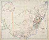
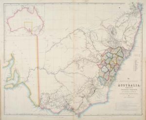
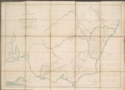
The Nineteen Counties
- GloucesterGloucester County, New South WalesGloucester Countys was one of the original Nineteen Counties in New South Wales, and is now one of the 141 Cadastral divisions of New South Wales. It includes the area around Port Stephens...
: northern-most boundary was the Manning RiverManning RiverThe Manning River is a river in the Mid North Coast of New South Wales, Australia that flows through the Manning Valley. It is one of Australia's few large river systems not to be dammed for water supply purposes anywhere along its catchment...
; the county incorporated Port Stephens - DurhamDurham County, New South WalesDurham County was one of the original Nineteen Counties in New South Wales and is now one of the 141 Cadastral divisions of New South Wales. It is bordered on the south and west by the Hunter River, and on the north and east by the Williams River. It includes Aberdeen and Muswellbrook...
: west of Gloucestor, southern Boundary was the Hunter RiverHunter RiverThe Hunter River is a major river in New South Wales, Australia. The Hunter River rises in the Liverpool Range and flows generally south and then east, reaching the Pacific Ocean at Newcastle, the second largest city in New South Wales and a major port.... - NorthumberlandNorthumberland County, New South WalesNorthumberland County was one of the original Nineteen Counties in New South Wales and is now one of the 141 Cadastral divisions of New South Wales. It included the area to the north of Broken Bay, including Lake Macquarie and Newcastle...
: northern boundary was the Hunter River and the southern boundary was formed by the Hawkesbury RiverHawkesbury RiverThe Hawkesbury River, also known as Deerubbun, is one of the major rivers of the coastal region of New South Wales, Australia. The Hawkesbury River and its tributaries virtually encircle the metropolitan region of Sydney.-Geography:-Course:... - CumberlandCumberland County, New South WalesCumberland County is a county in the State of New South Wales, Australia. Most of the Sydney metropolitan area is located within the County of Cumberland....
: incorporated SydneySydneySydney is the most populous city in Australia and the state capital of New South Wales. Sydney is located on Australia's south-east coast of the Tasman Sea. As of June 2010, the greater metropolitan area had an approximate population of 4.6 million people...
, WindsorWindsor, New South WalesWindsor is a town in the state of New South Wales, Australia. Windsor is located in the local government area of the City of Hawkesbury. It sits on the Hawkesbury River, on the north-western outskirts of the Sydney metropolitan area. At the 2006 census, Windsor had a population of...
, ParramattaParramatta, New South WalesParramatta is a suburb of Sydney, in the state of New South Wales, Australia. It is located in Greater Western Sydney west of the Sydney central business district on the banks of the Parramatta River. Parramatta is the administrative seat of the Local Government Area of the City of Parramatta...
, LiverpoolLiverpool, New South WalesLiverpool is a suburb in south-western Sydney, in the state of New South Wales, Australia. Liverpool is located 32 km south-west of the Sydney central business district, and is the administrative centre of the local government area of the City of Liverpool...
and AppinAppin, New South WalesAppin is a town in the Macarthur Region of New South Wales, Australia in Wollondilly Shire. It is situated about 16 kilometres south of Campbelltown and 35 kilometres north west of Wollongong.-Early history:...
to the south - CamdenCamden County, New South WalesCamden County was one of the original Nineteen Counties in New South Wales and is now one of the 141 Cadastral divisions of New South Wales. It included the coastal area near Wollongong south to the Shoalhaven River, and also inland encompassing Berrima and Picton. Its western boundary was the...
: included CamdenCamden, New South Wales-Education:Camden is the location of research facilities for the veterinary and agricultural schools of the University of Sydney. The local government area has two public high schools, Camden High School and Elderslie High School, as well as eight Catholic and three Anglican schools.-Culture:The...
, PictonPicton, New South WalesPicton is a small town in the Macarthur Region of New South Wales, Australia, in the Wollondilly Shire. The town is located 80 kilometres South-west of Sydney, close to Camden and Campbelltown. It is also the administrative centre of Wollondilly Shire....
and BerrimaBerrima, New South WalesBerrima is an historic village in the Southern Highlands of New South Wales, Australia, in Wingecarribee Shire. The village, once a major town, is located on the Old Hume Highway between Canberra and Sydney. It was previously known officially as the Town of Berrima...
with the southern-most border defined by the Shoalhaven RiverShoalhaven RiverThe Shoalhaven River is a river rising from the Southern Tablelands and flowing into the ocean near Nowra on the South Coast of New South Wales, Australia.- History :... - St Vincent: from the Shoalhaven River south to the Moruya RiverMoruya RiverThe Moruya River is in southern New South Wales, Australia. Its freshwater reaches are known as the Deua River.The headwaters of the Moruya River rise as the Deua River south of Braidwood...
, included Jervis BayJervis BayJervis Bay is a large bay bounded by the state of New South Wales, the Jervis Bay Territory, and a detached enclave of the Australian Capital Territory. HMAS Creswell is located between Jervis Bay Village and Greenpatch in the Jervis Bay Territory.-History:...
, Batemans BayBatemans Bay, New South Wales- Media :Radio Stations*East Coast Radio 2EC *Power FM NSW South Coast - POWER FM from Nowra can also be received in parts of Batemans Bay on FM 94.9....
and BraidwoodBraidwood, New South WalesBraidwood is a town in the Southern Tablelands of New South Wales, Australia, in Palerang Shire. It is located on the busy Kings Highway linking Canberra to Batemans Bay on the coast. It is about 200 kilometres south west of Sydney and about 60 kilometres inland from the coast... - Hunter County: west of the county of Northumberland, bounded by the Hunter River to the north
- CookCook County, New South WalesCook County was one of the original Nineteen Counties in New South Wales and is now one of the 141 Cadastral divisions of New South Wales. It includes the area to the west of Sydney in the Blue Mountains, between the Colo River in the north, and the Coxs River in the south and west, encompassing...
: west of Cumberland county and south of the county of Hunter - WestmorelandWestmoreland County, New South WalesWestmoreland County was one of the original Nineteen Counties in New South Wales and is now one of the 141 Cadastral divisions of New South Wales. It is to the west of Sydney in the Blue Mountains. Coxs River is the border to the north, and the Wollondilly River to the east...
: west of the counties of Cook and Camden - GeorgianaGeorgiana County, New South WalesGeorgiana County was one of the original Nineteen Counties in New South Wales and is now one of the 141 Cadastral divisions of New South Wales. It lies in the area about halfway between Bathurst and Goulburn. The Lachlan River is the western boundary, with the Crookwell River the southern boundary....
: west of the county of Westmoreland - KingKing County, New South WalesKing County was one of the original Nineteen Counties in New South Wales and is now one of the 141 Cadastral divisions of New South Wales. It is in the area to the east of Yass. The northern part of it lies between the Lachlan River and the Boorowa River, including the locations of Frogmore,...
: north of the county of Murray and west of the counties of Argyle and Georgiana - MurrayMurray County, New South WalesMurray County was one of the original Nineteen Counties in New South Wales and is now one of the 141 Lands administrative divisions of New South Wales. It included the area which is now part of Canberra and as far north as Lake George and Yass. It was originally bounded on the west by the...
: incorporating the Limestone Plains and Lake George, bounded by the Murrumbidgee RiverMurrumbidgee RiverThe Murrumbidgee River is a major river in the state of New South Wales, Australia, and the Australian Capital Territory . A major tributary of the Murray River, the Murrumbidgee flows in a west-northwesterly direction from the foot of Peppercorn Hill in the Fiery Range of the Snowy Mountains,...
to the west, the south western extent of limits of settlement - Argyle: west of Camden county, included GoulburnGoulburn, New South WalesGoulburn is a provincial city in the Southern Tablelands of New South Wales, Australia in Goulburn Mulwaree Council Local Government Area. It is located south-west of Sydney on the Hume Highway and above sea-level. On Census night 2006, Goulburn had a population of 20,127 people...
, bounded by the Shoalhaven River to the south east - Roxburgh: north east of the county of Bathurst, west of the counties of Cook and Hunter
- Bathurst: bounded by the Lachlan RiverLachlan River- Course :The river rises in the central highland of New South Wales, part of the Great Dividing Range, 13 km east of Gunning. Its major headwaters, the Carcoar River, the Belubula River and the Abercrombie River converge near the town of Cowra. Minor tributaries include the Morongla Creek...
to the south west, incorporating the town of BathurstBathurst, New South Wales-CBD and suburbs:Bathurst's CBD is located on William, George, Howick, Russell, and Durham Streets. The CBD is approximately 25 hectares and surrounds two city blocks. Within this block layout is banking, government services, shopping centres, retail shops, a park* and monuments...
, west of the counties of Roxburgh and Westmoreland - Brisbane: north of the Hunter River, west of the county of Durham, one of the northern-most counties
- Phillip: west of the county of Hunter and north of Roxburgh
- WellingtonWellington County, New South WalesWellington County is a county in New South Wales, Australia, which was one of the original Nineteen Counties. The town of Wellington is near the north-eastern edge. The Bell River is the boundary to the west, and the Cudgegong River to the north...
: north of Bathurst, the town of WellingtonWellington, New South WalesWellington is a town in inland New South Wales, Australia located at the junction of the Macquarie and Bell Rivers. The town is the administrative centre of the Wellington Shire Local Government Area. The town is 362 kilometres from Sydney on the Great Western Highway and Mitchell Highway...
was in the northwest of the county and the Macquarie River flowed through the middle - Bligh: the north-westernmost county, north of the county of Phillip and west of the county of Brisbane