
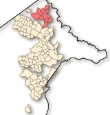
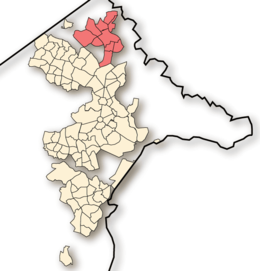
Gungahlin
Encyclopedia
Canberra
Canberra is the capital city of Australia. With a population of over 345,000, it is Australia's largest inland city and the eighth-largest city overall. The city is located at the northern end of the Australian Capital Territory , south-west of Sydney, and north-east of Melbourne...
, Australia
Australia
Australia , officially the Commonwealth of Australia, is a country in the Southern Hemisphere comprising the mainland of the Australian continent, the island of Tasmania, and numerous smaller islands in the Indian and Pacific Oceans. It is the world's sixth-largest country by total area...
. Gungahlin is situated 10 km north of Canberra's city centre and is one of five satellites of Canberra including Woden
Woden Valley
Woden Valley is a district of Canberra, the capital city of Australia. Its name is taken from the name of a nearby homestead owned by Dr James Murray who named the homestead after the Old English god Woden in October 1837. He named it this as he was to spend his life in the pursuit of wisdom and...
, Tuggeranong
Tuggeranong
Tuggeranong is the southernmost town centre of Canberra, the capital city of Australia. It comprises 19 suburbs with a total of 31,819 dwellings, housing 87,119 people of the 324,034 people in the Australian Capital Territory . The district occupies 117 square kilometres to the east of the...
, Weston Creek
Weston Creek
Weston Creek is a residential district of Canberra, Australian Capital Territory, Australia, situated to the west of the Woden Valley district and approximately 13 km southwest of the Canberra city centre...
and Belconnen
Belconnen
Belconnen is a district of Canberra, the capital city of Australia, comprising 25 suburbs with 29,900 dwellings housing 82,247 people of the 311,518 people in the Australian Capital Territory ....
. Currently Gungahlin comprises 11 suburbs, including three currently under construction and a further 7 suburbs planned. The word Gungahlin is Aboriginal in origin and means little rocky hill.
The population of the Gungahlin district stood at approximately 32,550 in 2006 and is expected to rise to 50,000 by 2014. Gungahlin’s cultural mix differs from other parts of Canberra and, there is a higher proportion of Chinese speaking residents than other parts of Canberra. Similarly, Korean, Filipino and Singhalese speakers are well represented in Gungahlin.
Transport
The primary mode of transport within the district is by private vehicle. Despite continued discussion about the preference for sustainable public transport especially light rail, Gungahlin's development is still guided by a philosophy of reliance on private personal transport and an extensive road network. Public buses serve the district.Public transport
The ACTION bus service which provides public transport throughout Canberra is the only form of regularly scheduled public transport in the Gungahlin district. Services from the various suburbs generally pass through a bus interchange located at the Gungahlin Town Centre from where they continue to Civic and the other town centres to Canberra’s south. Some services travel to Belconnen. There are also express services which connect directly with Tuggeranong. The Gungahlin bus interchange is located in Hibberson Street.Private transport
Private transport is the dominant mode of transport for Gungahlin commuters. The district's major arterial roads to North Canberra and the city centre are Northbourne Avenue via the Barton HighwayBarton Highway
The Barton Highway is a short highway in New South Wales and the Australian Capital Territory, Australia.The Barton Highway connects Canberra to the Hume Highway at Yass, and it is part of the route from Melbourne to Canberra....
, Horse Park Drive and Flemington Road. Gundaroo Drive-William Slim Drive is the main connection to the district of Belconnen. With the completion of the Gungahlin Drive Extension
Gungahlin Drive Extension
The Gungahlin Drive Extension is a major road project in Canberra, Australia. It is 9 kilometres long and extended the previously existing Gungahlin Drive from the Barton Highway in the district of Gungahlin to the Glenloch Interchange to connect with Parkes Way and the Tuggeranong Parkway. The...
in 2008, Gungahlin commuters can bypass the city centre to reach city's southern suburbs via Gungahlin Drive and onto William Hovell Drive and the Tuggeranong Parkway. Despite the roadwork completed to date, the Gungahlin Drive Extension in particular still experiences traffic congestion during peak times.
Over the next several years, a number of projects are expected to improve road access to the Gungahlin district including:
- Duplication of the remaining single lane sections of the Gungahlin Drive Extension.
- Duplication of Flemington Road to dual carriageway between the Gungahlin Town Centre and Northbourne Avenue
- Extension of Clarrie Hermes Drive at its westerly end through to the Barton Highway
- Completion of the remaining leg of Horse Park Drive which links the northern end of Gungahlin to the Federal Highway and onto Canberra Airport and parts beyond.
History
Ginninderra
Ginninderra is the name of the former agricultural lands surrendered to urban development on the western and north-western fringes of Canberra, Australia's National Capital...
. Ginninderra Village
Ginninderra
Ginninderra is the name of the former agricultural lands surrendered to urban development on the western and north-western fringes of Canberra, Australia's National Capital...
and later still the village of Hall serviced the needs of the local farming community. Free settlers included farming families such as the Rolfe, Shumack, Gillespie and Gribble families. These settlers established wheat and sheep properties such as 'Weetangara', 'Gold Creek'
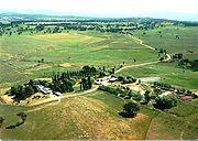
Gold Creek Homestead
Gold Creek Homestead is a 140-year old stone and brick building located off Gungahlin Drive in Ngunnawal a north-western suburb of Canberra, the Australian Capital Territory, Australia....
,'The Valley', ;Horse Park' and 'Tea Gardens'. Much of the local produce supplied the large workforce at goldfields located at Braidwood
Braidwood
-Places:* Braidwood, New South Wales, Australia* Braidwood, South Lanarkshire, Scotland* Braidwood, Illinois, United States of America-People:* Thomas Braidwood , founder of a school for the deaf in Scotland...
and Major's Creek.
Main article: Ginninderra
Ginninderra
Ginninderra is the name of the former agricultural lands surrendered to urban development on the western and north-western fringes of Canberra, Australia's National Capital...
Community and Sports Organisations
The Gungahlin Community Council is the peak community representative organisation for the district.Gungahlin local sport teams include the Gungahlin Eagles
Gungahlin Eagles
The Gungahlin Eagles are a rugby union club based in Gungahlin, Australian Capital Territory.-Club history:The club was founded as the Daramalan RUFC club in 1967, going on to win two premierships...
(rugby union
Rugby union
Rugby union, often simply referred to as rugby, is a full contact team sport which originated in England in the early 19th century. One of the two codes of rugby football, it is based on running with the ball in hand...
), the Gungahlin Bulls (rugby league
Rugby league
Rugby league football, usually called rugby league, is a full contact sport played by two teams of thirteen players on a rectangular grass field. One of the two codes of rugby football, it originated in England in 1895 by a split from Rugby Football Union over paying players...
) and the Gungahlin Jets (Australian rules football
Australian rules football
Australian rules football, officially known as Australian football, also called football, Aussie rules or footy is a sport played between two teams of 22 players on either...
).
Mulligans Flat Woodland Sanctuary friends group supports the feral-free enclosure behind Forde - an outdoor laboratory for the introduction of rare and threatened species.
List of suburbs
- AmarooAmaroo, Australian Capital TerritoryAmaroo is a suburb in the Canberra, Australia district of Gungahlin and was gazetted on 18 October 1991. Amaroo – which means ‘a beautiful place’ in one of the local Aboriginal dialects. Place names in Amaroo such as Shoalhaven Avenue are named after Australian rivers and lakes. Amaroo is adjacent...
- FordeForde, Australian Capital TerritoryForde is a northern suburb of the Canberra, Australia district of Gungahlin. It is named in honour of Frank Forde, a politician who was Prime Minister of Australia for a week in 1945 following the death of John Curtin. Forde is adjacent to the suburbs of Amaroo, Throsby and Bonner. It is bounded...
- GungahlinGungahlin, Australian Capital TerritoryGungahlin is a suburb in the Canberra, Australia district with the same name; Gungahlin. The postcode is 2912. Gungahlin is the name for the entire district, and also the town centre, but it is also the name of the suburb which Gungahlin Town Centre is in....
- HarrisonHarrison, Australian Capital TerritoryHarrison is a suburb of the district of Gungahlin in Canberra, Australia. The suburb is named after the former city planner Peter Harrison, who was instrumental in reviving Walter Burley Griffin's plan for the National Capital. The suburb is adjacent to the suburbs of Franklin, Gungahlin, Throsby,...
- NgunnawalNgunnawal, Australian Capital TerritoryNgunnawal is a suburb in the district of Gungahlin in Canberra, Australia. The suburb is named in tribute to the Ngunnawal people, the original inhabitants of the area. The suburb was gazetted on 18 October 1991. Ngunnawal is adjacent to the suburbs of Nicholls, Casey and Amaroo and Taylor...
- NichollsNicholls, Australian Capital TerritoryNicholls is a suburb in the Canberra, Australia district of Gungahlin is named after Sir Douglas Nicholls , a former Governor of South Australia. It was gazetted on 18 October 1991. Streets are named after sportsmen and sportswomen....
- PalmerstonPalmerston, Australian Capital TerritoryPalmerston is a suburb in the Canberra, Australia district of Gungahlin. The postcode is 2913. The suburb is named after George Thomas Palmer who established a settlement in the Canberra region in 1826 called Palmerville, which was later renamed Ginninderra. It was gazetted on 20 March 1991...
- BonnerBonner, Australian Capital TerritoryBonner is a planned suburb in the district of Gungahlin in Canberra. The suburb is named in memory after Senator Neville Bonner, Australia's first Indigenous parliamentarian who served the people of Queensland during the years 1971-1984...
* - CaseyCasey, Australian Capital TerritoryCasey is a suburb in Canberra, Australia , approximately 4 km from the Gungahlin Town Centre and about 13 km from the centre of Canberra. The suburb is named after Richard Casey, Baron Casey an Australian politician, diplomat and later the 16th Governor-General of Australia. It is bound...
* - CraceCrace, Australian Capital TerritoryCrace is a designated suburb of Canberra, Australia in the district of Gungahlin. It was named after Edward Kendall Crace an original settler in the Gungahlin area. Streets in Crace will be named after parishes and land divisions from colonial times. It is bounded by the Barton Highway, Gungahlin...
* - FranklinFranklin, Australian Capital TerritoryFranklin is a suburb of Canberra, Australia in the district of Gungahlin. It is named after the novelist Miles Franklin. The streets in Franklin are named after writers. It comprises an area of approximately 256 hectares...
* - JackaJacka, Australian Capital TerritoryJacka is a designated suburb of Gungahlin, Canberra, the National Capital of Australia. The suburb was gazetted in April 1991 though an official announcement is yet to be made about the first land release...
*
- Kinleyside *
- KennyKenny, Australian Capital TerritoryKenny is a designated suburb in the Canberra, Australia district of Gungahlin. The suburb is named in honour of Elizabeth Kenny, an Australian who pioneered muscle rehabilitation practices which serve as the foundation of physiotherapy...
* - MitchellMitchell, Australian Capital TerritoryMitchell is a light-industrial estate of Canberra, Australia in the district of Gungahlin. Mitchell was named in honour of Major Sir Thomas Livingston Mitchell, an explorer of inland New South Wales and Surveyor-General of New South Wales. The streets in Mitchell are named after Australian...
* - MoncrieffMoncrieff, Australian Capital TerritoryMoncrieff is a designated suburb of Gungahlin, Canberra, the National Capital of Australia. The name was gazetted in April 1991 though no official announcement has to be made about the first land release. It is named after Gladys Moncrieff, an Australian singer of the 1920-30s musical era who was...
* - TaylorTaylor, Australian Capital TerritoryTaylor is a designated suburb in Gungahlin, Canberra though the first land release is yet to be announced. The suburb is named after magazine publisher Florence Taylor OBE, who was editor of and writer for several Australian building industry journals including the influential 'Building' magazine...
* - ThrosbyThrosby, Australian Capital TerritoryThrosby is a designated suburb of Canberra, Australia in the district of Gungahlin. The suburb is adjacent to the suburbs of Kenny and Harrison and is bounded by the Federal Highway to the east, the ACT/NSW border to the north, Horse Park Drive to the south and the Goorooyarroo nature reserve to...
*
Asterisk indicates future suburbs and those currently under development
Schools
- Gold Creek School
- Holy Spirit Primary School
- Good Shepherd Primary School
- Palmerston Primary School
- Amaroo School
- Burgmann Anglican School
- Ngunnawal Primary School
- Harrison School
External links
- Gungahlin suburbs map - links to ACT Government street-level maps.
- Canberra region map - all districts
- Australian Bureau of Statistics