

A149 road
Encyclopedia
The A149 is a major route in Norfolk
, linking Kings Lynn to Great Yarmouth
. It runs via the coast rather than on a more direct route such as the A47
. The eastern section runs through The Broads
.
between Kings Lynn and South Lynn. The A149 heads east towards Hardwick Roundabout. Hardwick intersection is a major junction in West Norfolk
with the A47 to Norwich
and Wisbech
crossing the Junction and the A10 running of to the south. The A149 heads North East signposted to Cromer. At rush hour the road can be extremely busy especially between the Hardwick intersection and the next two roundabouts at the Queen Elizabeth Hospital
(to the left) and the northern end of Kings Lynn at its junction with the A148
Cromer
road. At this roundaboutit follows on towards Hunstanton
. The road passes over the River Babingley
past the Ruins of St Felix's church and the deserted village of Babingley
, part of the Royal Estate of Sandringham
which is on the right before reaching Dersingham
, which the road now by-passes, along with the villages of Ingoldisthorpe
and Snettisham
and passing over the River Ingol
. The road then reaches the village of Heacham
. At Heacham there is a staggered cross roads junction with the B1454. The so-called Lavender junction (next to the Norfolk Lavender fields) has a wide central island with gaps to allow turning traffic.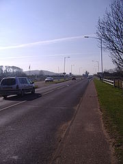 Beyond the junction the road passes over the River Heacham
and on the right is Caley Mill. A short distance further on is the seaside
town of Hunstanton
on The Wash
15.7 miles (25.3 km) from the start of the road. To the south of the town the road reaches a roundabout with the B1161 which features a rock garden. The road skirts the eastern side of the town and just before passing through Old Hunstanton gives a view of the sea. The road now turns easterly passing over the bridge of the River Hun
, which is reputedly Roman
, and passes through the Village of Holme next the Sea. The road now heads East across the Marshland of Brancaster Bay passing through the villages of Thornham
, Titchwell
and on to Brancaster
(22.7 miles (36.5 km) from start). The road now passes through an area of Outstanding Natural Beauty.
.jpg) Between Brancaster and Brancaster Staithe the road widens on a new alignment, the old one now being a layby in which stands an old black AA call box from a by-gone motoring age, which now has listed building status. The hamlet
Between Brancaster and Brancaster Staithe the road widens on a new alignment, the old one now being a layby in which stands an old black AA call box from a by-gone motoring age, which now has listed building status. The hamlet
of Brancaster Staithe is next, with access to Brancaster Harbour, and on to Burnham Deepdale, Burnham Norton
, and Burnham Overy Staithe.
The road now runs along Holkham
Bay towards Wells next the Sea. 1+1/2 mi from Burnham Overy Staithe, on the right you pass the Holkham Estate
, the home of Thomas, Viscount Coke, the Earl Of Leicester
. On the left are beaches and the Pine backed sand dunes of Holkham, which form part of the Holkham National Nature Reserve. The road now skirts around the south side of Wells next the Sea, (32 miles (51.5 km) from start) and heads east again.
. From here the road runs south of Stiffkey
Salt marshes. This stretch of the road runs parallel with the “Peddars Way
” section of the North Norfolk Coastal Path
, which is about 1/4 mi north and runs along the fringe of the marshes. In Stiffkey, the road narrows to a single lane causing approaching traffic to give way. Beyond the village the road crosses the River Stiffkey
. The next village on the road is Morston
(38 miles (61.2 km) from the start), The road skirts around the south of the village.
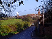 After Blakeney, the road descends into the Glaven Valley
, and into view comes the landmark of Cley next the Sea
Windmill
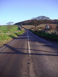
. Again the road becomes a bottle neck in the summer months as it pass through the village of Cley next the Sea. The next stretch of the road between Cley and Sheringham
is a very scenic part of the A149. After negotiating the narrow streets of Cley the road runs along the coast south of Cley and Salthouse
salt marshes, the sea is hidden by a long bank of shingle
that runs along the shore
line here. The marshes are a Nature Reserve and all along this stretch of the road there are lay-bys and car parks which are used as viewing points.
The road now rises away from the marsh
es and twists and turns into the next village of Kelling
. The road now passes through the gentle and heaths of Kelling Heath
and Weybourne. Just before entering the village of Weybourne, the road passes Weybourne Camp on the left. The road now passes through the village of Weybourne (45.5 miles (73.2 km)) and up a hill past the village Windmill
.
 As the road stretches off to Sheringham
it passes under a railway bridge carrying the North Norfolk Railway
. The road now passes through a stretch of land that is owned by The National Trust
. As then runs right alongside the A149, squeezed between the road and the Sheringham Golf Club which is set on the cliffs in an Area of Outstanding Natural Beauty. The mini roundabout at Sheringham it is 48.2 miles (77.6 km) from the start of the A149 at Kings Lynn.
.jpg) Sheringham is a seaside resort. The route now passes the terminus for the North Norfolk Railway on the left. The A149 runs south of the heart of the town, passing the prominent hill on the left known locally as "Beeston Bump". The road now also has a railway line running parallel on the seaward side. At 49 miles (78.9 km) the road reaches the village of Beeston Regis
Sheringham is a seaside resort. The route now passes the terminus for the North Norfolk Railway on the left. The A149 runs south of the heart of the town, passing the prominent hill on the left known locally as "Beeston Bump". The road now also has a railway line running parallel on the seaward side. At 49 miles (78.9 km) the road reaches the village of Beeston Regis
followed by West Runton
. The last village before Cromer is East Runton
were the landscape of the coast is peppered with static caravans
or mobile home
s. The A149 now reaches the fading Victorian
splendour of Cromer (52.3 miles (84.2 km)). The road drops down in to the town, with a splendid view of the town’s pier
, where it dog-legs through the town's one way system. This part of the road becomes congested in the summer months and long queues form in the one-way system. Cromer marks the end of the roads route along the coast, as it turns south-east to cut across Norfolk
towards its end at Great Yarmouth
.
towards the next village of Northrepps
and past the turning on the right of the A140
which is the main road to Norwich
. Passing through well ordered arable farmland the road then reaches a cross roads, with the B1436
just before the village of Thorpe Market
. The B1436 links the Cromer
-Holt
road to Mundesley
on the coast. Out of the village the road runs along the boundary of Gunton Park, with some 800 acres (3.2 km²) of Deer park, on the right. Further on is the village of Antingham
before reaching North Walsham
, (61 miles (98.2 km) from Kings Lynn). At North Walsham there is a junction controlled with traffic lights. Here the road turn right and takes a new route around the western side of the Town, past the Bacton Gas terminal’s
link to the rail network. The old route would have taken you through the busy town centre. This new route runs part of the way along what was the disused track bed of the Midland and Great Northern Joint Railway (M&GN)
railway between Stalham
and North Walsham. Heading towards the Norfolk Broads
(part of the Norfolk and Suffolk Broads Authority , the road passes the villages of Worstead
and Dilham
and then passes through Smallburgh were the road clips The Broads. Just past Smallburgh the road turns left at a “T” Junction. The road to the right is the A1151
, from Wroxham
and Norwich
, which terminates at this junction. The road now takes a large north easterly arch around Barton Broad
, crossing the River Ant
at Wayford Bridge
. The road now curves back towards Stalham passing several Boat Hire yards. Stalham is 69 miles (111 km) from the start of the A149, and from here the road cuts across the flatlands of Norfolk
skirting The Broads as it goes.
 Long straights characterise this 5 miles (8 km) stretch from Stalham
to Potter Heigham
. The straights pass through the villages of Sutton
and Catfield
. This part of the A149 has a bad reputation for fatalities and care should be taken at all the junctions that dissect this 5 miles (8 km) stretch. Most of this section is not the original route of the road. The original road runs parallel on the right, the new route effectively by-passing out the villages, and at Potter Heigham Bridge
(74 miles (119.1 km)) the two roads converge. After Potter Heigham
the next village is Repps with Bastwick
followed by Rollesby
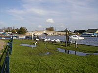
(77 miles (123.9 km)). At Rollesby the road crosses Ormesby Broad
were there is parking if you wish to visit this Broad. Past the large water works on the left and the road now passes through Ormesby St. Michael
and then Ormesby St. Margaret
. Before coming to another roundabout junction. This is the terminus of the A1064 which has come across the Broads from Acle
a distance of 7.2 miles (11.6 km) in all. Looking straight across the roundabout is the site of Caister Castle
. The A149 is now a Dual Carriageway
and, at another junction, bypasses Caister-on-Sea
. After the bypass, the road narrows back to a Single Carriageway
as it enters Great Yarmouth
. The road now heads south, past the Banger racing
track and stadium, and the Heliport at North Denes Airfield
, on the right. On the left is Great Yarmouth race course. The road passes the railway station and follows the east bank of the River Bure
. At the large roundabout the A149 comes to an end, as does the A47
and the A12. The total distance from Hardwick flyover to this roundabout in Great Yarmouth is 85.237 miles (137.2 km) (Goggle Pedometer).
Norfolk
Norfolk is a low-lying county in the East of England. It has borders with Lincolnshire to the west, Cambridgeshire to the west and southwest and Suffolk to the south. Its northern and eastern boundaries are the North Sea coast and to the north-west the county is bordered by The Wash. The county...
, linking Kings Lynn to Great Yarmouth
Great Yarmouth
Great Yarmouth, often known to locals as Yarmouth, is a coastal town in Norfolk, England. It is at the mouth of the River Yare, east of Norwich.It has been a seaside resort since 1760, and is the gateway from the Norfolk Broads to the sea...
. It runs via the coast rather than on a more direct route such as the A47
A47 road
The A47 is a trunk road in England originally linking Birmingham to Great Yarmouth. Most of the section between Birmingham and Nuneaton is now classified as the B4114.-Route:...
. The eastern section runs through The Broads
The Broads
The Broads are a network of mostly navigable rivers and lakes in the English counties of Norfolk and Suffolk. The Broads, and some surrounding land were constituted as a special area with a level of protection similar to a UK National Park by The Norfolk and Suffolk Broads Act of 1988...
.
Kings Lynn to Wells next the Sea
The A149 begins at a roundaboutRoundabout
A roundabout is the name for a road junction in which traffic moves in one direction around a central island. The word dates from the early 20th century. Roundabouts are common in many countries around the world...
between Kings Lynn and South Lynn. The A149 heads east towards Hardwick Roundabout. Hardwick intersection is a major junction in West Norfolk
King's Lynn and West Norfolk
King's Lynn and West Norfolk is a local government district and borough in Norfolk, England. Its council is based in the town of King's Lynn.-History:...
with the A47 to Norwich
Norwich
Norwich is a city in England. It is the regional administrative centre and county town of Norfolk. During the 11th century, Norwich was the largest city in England after London, and one of the most important places in the kingdom...
and Wisbech
Wisbech
Wisbech is a market town, inland port and civil parish with a population of 20,200 in the Fens of Cambridgeshire. The tidal River Nene runs through the centre of the town and is spanned by two bridges...
crossing the Junction and the A10 running of to the south. The A149 heads North East signposted to Cromer. At rush hour the road can be extremely busy especially between the Hardwick intersection and the next two roundabouts at the Queen Elizabeth Hospital
Queen Elizabeth Hospital, King's Lynn
The Queen Elizabeth Hospital is an acute NHS District General Hospital located in the town of King’s Lynn in Norfolk, England. It is located on the outskirts of King’s Lynn, to the eastern edge of the town...
(to the left) and the northern end of Kings Lynn at its junction with the A148
A148 road
The A148 is an English A road entirely in the county of Norfolk. It runs from King's Lynn to Cromer via Fakenham which it bypasses to the north.-King’s Lynn starting point:...
Cromer
Cromer
Cromer is a coastal town and civil parish in north Norfolk, England. The local government authority is North Norfolk District Council, whose headquarters is in Holt Road in the town. The town is situated 23 miles north of the county town, Norwich, and is 4 miles east of Sheringham...
road. At this roundaboutit follows on towards Hunstanton
Hunstanton
Hunstanton, often pronounced by locals as and known colloquially as 'Sunny Hunny', is a seaside town in Norfolk, England, facing The Wash....
. The road passes over the River Babingley
River Babingley
The Babingley is a minor river in the northwest of the county Norfolk in England. It runs from its source at the village of Flitcham to the River Great Ouse at Wootton Marshes were it terminates....
past the Ruins of St Felix's church and the deserted village of Babingley
Babingley
Babingley is one of Norfolk's lost villages. This small parish was located on the western side of the A149, 1 mile north-west of Castle Rising, and 5½ miles north-north-east of King's Lynn. Today, the village of Babingley is constituted by several houses on the A149 - the King's Lynn to Hunstanton...
, part of the Royal Estate of Sandringham
Sandringham House
Sandringham House is a country house on of land near the village of Sandringham in Norfolk, England. The house is privately owned by the British Royal Family and is located on the royal Sandringham Estate, which lies within the Norfolk Coast Area of Outstanding Natural Beauty.-History and current...
which is on the right before reaching Dersingham
Dersingham
Dersingham is a village and civil parish in the English county of Norfolk. It is situated some north of the town of King's Lynn and north-west of the city of Norwich, opening onto the Wash....
, which the road now by-passes, along with the villages of Ingoldisthorpe
Ingoldisthorpe
Ingoldisthorpe is a village and civil parish in the north-west of the English county of Norfolk. It is located approximately north-east of the town King's Lynn and from the county town of Norwich....
and Snettisham
Snettisham
Snettisham is a village and civil parish in the English county of Norfolk. It is located near the west coast of Norfolk, some south of the seaside resort of Hunstanton, north of the town of King's Lynn and north-west of the city of Norwich....
and passing over the River Ingol
River Ingol
The River Ingol is a small river in the west of the English county of Norfolk.-The Source:The source of the river can be found a little to the west of the village of Shernborne, about 30m above sea level...
. The road then reaches the village of Heacham
Heacham
Heacham is a village of 4,707 inhabitants, located in north-west Norfolk, England, between King's Lynn, to the south and Hunstanton, about to the north, on The Wash.- History :...
. At Heacham there is a staggered cross roads junction with the B1454. The so-called Lavender junction (next to the Norfolk Lavender fields) has a wide central island with gaps to allow turning traffic.
River Heacham
The River Heacham is in the North West of the County of Norfolk. Its source is in the village of Bircham Newton , 25 metres above sea level. The river is 6.8 miles long from the source to the pools behind the tidal flaps at North beach, Heacham...
and on the right is Caley Mill. A short distance further on is the seaside
Seaside resort
A seaside resort is a resort, or resort town, located on the coast. Where a beach is the primary focus for tourists, it may be called a beach resort.- Overview :...
town of Hunstanton
Hunstanton
Hunstanton, often pronounced by locals as and known colloquially as 'Sunny Hunny', is a seaside town in Norfolk, England, facing The Wash....
on The Wash
The Wash
The Wash is the square-mouthed bay and estuary on the northwest margin of East Anglia on the east coast of England, where Norfolk meets Lincolnshire. It is among the largest estuaries in the United Kingdom...
15.7 miles (25.3 km) from the start of the road. To the south of the town the road reaches a roundabout with the B1161 which features a rock garden. The road skirts the eastern side of the town and just before passing through Old Hunstanton gives a view of the sea. The road now turns easterly passing over the bridge of the River Hun
River Hun (Norfolk)
The River Hun is in the west of the county of Norfolk, in England. Its source is in the Grounds of Hunstanton Park. Its mouth can be found on the North Sea near Holme Next The SeaIn the 11th century it was known as 'Esten broke' ....
, which is reputedly Roman
Roman road
The Roman roads were a vital part of the development of the Roman state, from about 500 BC through the expansion during the Roman Republic and the Roman Empire. Roman roads enabled the Romans to move armies and trade goods and to communicate. The Roman road system spanned more than 400,000 km...
, and passes through the Village of Holme next the Sea. The road now heads East across the Marshland of Brancaster Bay passing through the villages of Thornham
Thornham, Norfolk
Thornham is a village and civil parish in the English county of Norfolk. It is situated on the north Norfolk coast some north-east of the seaside resort of Hunstanton, north of the town of King's Lynn and north-west of the city of Norwich....
, Titchwell
Titchwell
Titchwell is a village and civil parish in the English county of Norfolk. It is situated on the north Norfolk coast some west of the village of Brancaster, north-east of the seaside resort of Hunstanton, north of the town of King's Lynn and north-west of the city of Norwich.The civil parish has...
and on to Brancaster
Brancaster
Brancaster is a village and civil parish on the north coast of the English county of Norfolk. The civil parish of Brancaster comprises Brancaster itself, together with Brancaster Staithe and Burnham Deepdale...
(22.7 miles (36.5 km) from start). The road now passes through an area of Outstanding Natural Beauty.
Hamlet (place)
A hamlet is usually a rural settlement which is too small to be considered a village, though sometimes the word is used for a different sort of community. Historically, when a hamlet became large enough to justify building a church, it was then classified as a village...
of Brancaster Staithe is next, with access to Brancaster Harbour, and on to Burnham Deepdale, Burnham Norton
Burnham Norton
Burnham Norton is a village and civil parish in the English county of Norfolk. Burnham Norton is one of the Burnhams, a group of adjacent villages in North Norfolk...
, and Burnham Overy Staithe.
The road now runs along Holkham
Holkham
Holkham is a village and civil parish in the north-west of the county of Norfolk, England. Besides the small village, the parish includes the major stately home and estate of Holkham Hall, and an attractive beach at Holkham Gap...
Bay towards Wells next the Sea. 1+1/2 mi from Burnham Overy Staithe, on the right you pass the Holkham Estate
Holkham Hall
Holkham Hall is an eighteenth-century country house located adjacent to the village of Holkham, on the north coast of the English county of Norfolk...
, the home of Thomas, Viscount Coke, the Earl Of Leicester
Earl of Leicester
The title Earl of Leicester was created in the 12th century in the Peerage of England , and is currently a title in the Peerage of the United Kingdom, created in 1837.-Early creations:...
. On the left are beaches and the Pine backed sand dunes of Holkham, which form part of the Holkham National Nature Reserve. The road now skirts around the south side of Wells next the Sea, (32 miles (51.5 km) from start) and heads east again.
Wells next the Sea to Cromer
Just out of Wells, the road passes on the right, the Wells and Walsingham Light RailwayWells and Walsingham Light Railway
The Wells and Walsingham Light Railway is a gauge heritage railway in Norfolk, England running between the coastal town of Wells and Walsingham which is further inland...
. From here the road runs south of Stiffkey
Stiffkey
Stiffkey is a village and civil parish on the north coast of the English county of Norfolk. It is situated on the A149 coast road, some east of Wells-next-the-Sea, west of Blakeney, and north-west of the city of Norwich....
Salt marshes. This stretch of the road runs parallel with the “Peddars Way
Peddars Way
The Peddars Way is a long distance footpath in Norfolk, England. It is 46 miles long and follows the route of a Roman road. It has been suggested by more than one writer that it was not created by the Romans but was an ancient trackway, a branch or extension of the Icknield Way, used and...
” section of the North Norfolk Coastal Path
North Norfolk Coastal Path
The Norfolk Coast Path is a long distance footpath in Norfolk, running 45 miles from Hunstanton to Cromer. It was opened in 1986 and covers the North Norfolk Coast AONB ....
, which is about 1/4 mi north and runs along the fringe of the marshes. In Stiffkey, the road narrows to a single lane causing approaching traffic to give way. Beyond the village the road crosses the River Stiffkey
River Stiffkey
The River Stiffkey is a chalk stream running through an area of north Norfolk, England from its source near Swanton Novers to flow out into the North Sea on the north Norfolk coast near the town of Stiffkey...
. The next village on the road is Morston
Morston
Morston is a village and civil parish in the English county of Norfolk.It covers an area of and had a population of 86 in 42 households as of the 2001 census.For the purposes of local government, it falls within the district of North Norfolk....
(38 miles (61.2 km) from the start), The road skirts around the south of the village.
River Glaven
The River Glaven is 10½ miles long and flows through picturesque North Norfolk countryside. Rising from a tiny headwater in Bodham the river starts just 2 miles before Selbrigg Pond where three streams combine at the outfall...
, and into view comes the landmark of Cley next the Sea
Cley next the Sea
Cley next the Sea is a village on the River Glaven in Norfolk, England, 4 miles north-west of Holt and east of Blakeney. The main A149 coast road runs through the centre of the village, causing congestion in the summer months due to the tight, narrow streets. It lies within the Norfolk Coast AONB...
Windmill
Windmill
A windmill is a machine which converts the energy of wind into rotational energy by means of vanes called sails or blades. Originally windmills were developed for milling grain for food production. In the course of history the windmill was adapted to many other industrial uses. An important...
. Again the road becomes a bottle neck in the summer months as it pass through the village of Cley next the Sea. The next stretch of the road between Cley and Sheringham
Sheringham
Sheringham is a seaside town in Norfolk, England, west of Cromer.The motto of the town, granted in 1953 to the Sheringham Urban District Council, is Mare Ditat Pinusque Decorat, Latin for "The sea enriches and the pine adorns"....
is a very scenic part of the A149. After negotiating the narrow streets of Cley the road runs along the coast south of Cley and Salthouse
Salthouse
Salthouse is a village and a civil parish in the English county of Norfolk. It is situated on the salt marshes of North Norfolk. It is north of Holt, west of Sheringham and north of Norwich. The village is on the A149 coast road between King's Lynn and Great Yarmouth. The nearest railway station...
salt marshes, the sea is hidden by a long bank of shingle
Shingle beach
A shingle beach is a beach which is armoured with pebbles or small- to medium-sized cobbles. Typically, the stone composition may grade from characteristic sizes ranging from two to 200 mm diameter....
that runs along the shore
Shore
A shore or shoreline is the fringe of land at the edge of a large body of water, such as an ocean, sea, or lake. In Physical Oceanography a shore is the wider fringe that is geologically modified by the action of the body of water past and present, while the beach is at the edge of the shore,...
line here. The marshes are a Nature Reserve and all along this stretch of the road there are lay-bys and car parks which are used as viewing points.
The road now rises away from the marsh
Marsh
In geography, a marsh, or morass, is a type of wetland that is subject to frequent or continuous flood. Typically the water is shallow and features grasses, rushes, reeds, typhas, sedges, other herbaceous plants, and moss....
es and twists and turns into the next village of Kelling
Kelling
Kelling is a village and a civil parish in the English county of Norfolk. The village is west of Cromer, north of Norwich and north-east of London. The village straddles the A149 Coast road between Kings Lynn and Great Yarmouth...
. The road now passes through the gentle and heaths of Kelling Heath
Kelling Heath
Kelling Heath is an area of heathland on the coast of North Norfolk, England, between Holt and Weybourne. It has been designated a Site of Special Scientific Interest, and is described by Natural England as 'a fine example of oceanic heathland'...
and Weybourne. Just before entering the village of Weybourne, the road passes Weybourne Camp on the left. The road now passes through the village of Weybourne (45.5 miles (73.2 km)) and up a hill past the village Windmill
Weybourne Windmill
Weybourne Windmill is located on the eastern high ground above the village of Weybourne in the English county of Norfolk. It is on the northern side of the A149 coastal road that links King’s Lynn to Great Yarmouth. The Windmill is 3 miles west of Sheringham and is within the Norfolk Coast AONB...
.
Sheringham
Sheringham is a seaside town in Norfolk, England, west of Cromer.The motto of the town, granted in 1953 to the Sheringham Urban District Council, is Mare Ditat Pinusque Decorat, Latin for "The sea enriches and the pine adorns"....
it passes under a railway bridge carrying the North Norfolk Railway
North Norfolk Railway
The North Norfolk Railway – also known as the "Poppy Line" – is a heritage steam railway in Norfolk, England, running between the coastal town of Sheringham and Holt, It cuts through the countryside to the east of Weybourne with views of its windmill and passes through the well preserved country...
. The road now passes through a stretch of land that is owned by The National Trust
National Trust for Places of Historic Interest or Natural Beauty
The National Trust for Places of Historic Interest or Natural Beauty, usually known as the National Trust, is a conservation organisation in England, Wales and Northern Ireland...
. As then runs right alongside the A149, squeezed between the road and the Sheringham Golf Club which is set on the cliffs in an Area of Outstanding Natural Beauty. The mini roundabout at Sheringham it is 48.2 miles (77.6 km) from the start of the A149 at Kings Lynn.
Beeston Regis
Beeston Regis is a village and civil parish in the North Norfolk district of Norfolk, England. It is about a mile east of Sheringham, Norfolk and near the coast. According to the 2001 census it had a population of 1,091...
followed by West Runton
West Runton
West Runton is a village in North Norfolk, England, approximately ¼ of a mile from the North Sea coast.-Overview:West Runton and East Runton together form the parish of Runton. The village straddles the A149 North Norfolk coast road and is 2½ miles west of Cromer and 1½ miles east of Sheringham...
. The last village before Cromer is East Runton
East Runton
East Runton is a small village in Norfolk, England situated close to the North Sea. It was once a traditional fishing village outside Cromer but is now a popular holiday destination for camping and caravan holidays. The village is within the parish of Runton that also includes West Runton. The...
were the landscape of the coast is peppered with static caravans
Travel trailer
A travel trailer or caravan is towed behind a road vehicle to provide a place to sleep which is more comfortable and protected than a tent . It provides the means for people to have their own home on a journey or a vacation, without relying on a motel or hotel, and enables them to stay in places...
or mobile home
Mobile home
Mobile homes or static caravans are prefabricated homes built in factories, rather than on site, and then taken to the place where they will be occupied...
s. The A149 now reaches the fading Victorian
Victorian architecture
The term Victorian architecture refers collectively to several architectural styles employed predominantly during the middle and late 19th century. The period that it indicates may slightly overlap the actual reign, 20 June 1837 – 22 January 1901, of Queen Victoria. This represents the British and...
splendour of Cromer (52.3 miles (84.2 km)). The road drops down in to the town, with a splendid view of the town’s pier
Cromer Pier
Cromer Pier is a seaside pier in the civil parish of Cromer on the north coast of the English county of Norfolk, 40 km due north of the city of Norwich in the United Kingdom. The pier is the home of the Cromer Lifeboat Station and the Pavilion Theatre...
, where it dog-legs through the town's one way system. This part of the road becomes congested in the summer months and long queues form in the one-way system. Cromer marks the end of the roads route along the coast, as it turns south-east to cut across Norfolk
Norfolk
Norfolk is a low-lying county in the East of England. It has borders with Lincolnshire to the west, Cambridgeshire to the west and southwest and Suffolk to the south. Its northern and eastern boundaries are the North Sea coast and to the north-west the county is bordered by The Wash. The county...
towards its end at Great Yarmouth
Great Yarmouth
Great Yarmouth, often known to locals as Yarmouth, is a coastal town in Norfolk, England. It is at the mouth of the River Yare, east of Norwich.It has been a seaside resort since 1760, and is the gateway from the Norfolk Broads to the sea...
.
Cromer to Stalham
The road climbs a hill southwards, out of Cromer, past Cromer High SchoolCromer High School
Cromer High School and Sports College is a British state school in Cromer, Norfolk. It has around 517 pupils aged 11-16, a drop in numbers from 715 in March 2006 and has had the specialist school status of a Sports College since July, 2010. Having been a Language College from July 2001 until July...
towards the next village of Northrepps
Northrepps
Northrepps is a village and a civil parish in the English county of Norfolk. The village is southeast of Cromer, north of Norwich and north of London. The village lies west of the A149 which runs between Kings Lynn and Great Yarmouth. The nearest railway station is at Cromer for the Bittern...
and past the turning on the right of the A140
A140 road
The A140 is an 'A-class' road in Norfolk and Suffolk, East Anglia, England partly following the route of the Roman Pye Road. It runs from the A14 near Needham Market to the A149 south of Cromer. It is of primary status for the entirety of its route. It is approximately 56 miles in length...
which is the main road to Norwich
Norwich
Norwich is a city in England. It is the regional administrative centre and county town of Norfolk. During the 11th century, Norwich was the largest city in England after London, and one of the most important places in the kingdom...
. Passing through well ordered arable farmland the road then reaches a cross roads, with the B1436
B1436 road
The B1436 runs for about through Norfolk, England, from a little southwest of Cromer to Thorpe Market. It is a useful conduit to avoid the busy seaside town of Cromer during the summer months and links the A148 from Kings Lynn to the A140 to Norwich and the A149 to Great Yarmouth.-History:The...
just before the village of Thorpe Market
Thorpe Market
Thorpe Market is a village in the English county of Norfolk. The village is 4.4 miles south of Cromer, and 20.5 miles north of Norwich. The nearest railway station is at Gunton for the Bittern Line which runs between Sheringham, Cromer and Norwich. The nearest airport is Norwich International...
. The B1436 links the Cromer
Cromer
Cromer is a coastal town and civil parish in north Norfolk, England. The local government authority is North Norfolk District Council, whose headquarters is in Holt Road in the town. The town is situated 23 miles north of the county town, Norwich, and is 4 miles east of Sheringham...
-Holt
Holt, Norfolk
Holt is a market town and civil parish in the English county of Norfolk. The town is north of the city of Norwich, west of Cromer and east of King's Lynn. The town is on the route of the A148 King's Lynn to Cromer road. The nearest railway station is in the town of Sheringham where access to the...
road to Mundesley
Mundesley
Mundesley is a coastal village and a civil parish in the English county of Norfolk. The village is 20.3 miles north-north east of Norwich, 7.3 miles south east of Cromer and 136 miles north east of London. The village lies 5.6 miles north-north east of the town of North Walsham. The nearest...
on the coast. Out of the village the road runs along the boundary of Gunton Park, with some 800 acres (3.2 km²) of Deer park, on the right. Further on is the village of Antingham
Antingham
Antingham is a village and civil parish in the north of the English county of Norfolk. The village is located about south of Cromer and north of North Walsham...
before reaching North Walsham
North Walsham
North Walsham is a market town and civil parish in Norfolk, England in the North Norfolk district.-Demographics:The civil parish has an area of and in the 2001 census had a population of 11,998. For the purposes of local government, the parish falls within the district of North...
, (61 miles (98.2 km) from Kings Lynn). At North Walsham there is a junction controlled with traffic lights. Here the road turn right and takes a new route around the western side of the Town, past the Bacton Gas terminal’s
Interconnector
The Interconnector is a natural gas pipeline between the United Kingdom and continental Europe. It crosses the North Sea between Bacton Gas Terminal in England and Zeebrugge in Belgium. Construction of the pipeline was completed in 1998. It provides bi-directional transport capability to...
link to the rail network. The old route would have taken you through the busy town centre. This new route runs part of the way along what was the disused track bed of the Midland and Great Northern Joint Railway (M&GN)
Midland and Great Northern Joint Railway
The Midland and Great Northern Joint Railway, was a joint railway owned by the Midland Railway and the Great Northern Railway in eastern England, affectionately known as the 'Muddle and Get Nowhere' to generations of passengers, enthusiasts, and other users.The main line ran from Peterborough to...
railway between Stalham
Stalham
Stalham is a market town on the River Ant in the English county of Norfolk, in East Anglia. It covers an area of and had a population of 2,951 in 1,333 households as of the 2001 census. It lies within the Norfolk Broads, about north-east of Norwich on the A149 road.For the purposes of local...
and North Walsham. Heading towards the Norfolk Broads
The Broads
The Broads are a network of mostly navigable rivers and lakes in the English counties of Norfolk and Suffolk. The Broads, and some surrounding land were constituted as a special area with a level of protection similar to a UK National Park by The Norfolk and Suffolk Broads Act of 1988...
(part of the Norfolk and Suffolk Broads Authority , the road passes the villages of Worstead
Worstead
Worstead is a village and civil parish in the English county of Norfolk. It lies 5 km south of North Walsham, 9 km north of Wroxham, and 20 km north of Norwich. The village is served by Worstead railway station on the Bittern Line....
and Dilham
Dilham
Dilham is a village and civil parish covering an area of with a population of 301 in 128 homes as of the 2001 census. It is on the River Ant just of the A149 road, near Stalham in Norfolk, England within The Broads...
and then passes through Smallburgh were the road clips The Broads. Just past Smallburgh the road turns left at a “T” Junction. The road to the right is the A1151
A1151 road
The A1151 is an A road, running entirely in the English county of Norfolk, in the East Anglia region of England. The road runs from the city of Norwich, and terminates at a junction with the A149, near Smallburgh.-Route:...
, from Wroxham
Wroxham
Wroxham is a village and civil parish in the English county of Norfolk. The civil parish of Wroxham has an area of 6.21 square kilometres and in 2001 had a population of 1532 in 666 households. The village is situated within the Norfolk Broads on the south side of a loop in the middle reaches of...
and Norwich
Norwich
Norwich is a city in England. It is the regional administrative centre and county town of Norfolk. During the 11th century, Norwich was the largest city in England after London, and one of the most important places in the kingdom...
, which terminates at this junction. The road now takes a large north easterly arch around Barton Broad
Barton Broad
Barton Broad lies within The Broads in Norfolk, the United Kingdom. The broad is situated to the south and east of the village of Barton Turf, and is within the parish of Barton Turf....
, crossing the River Ant
River Ant
The River Ant is a tributary river of the River Bure in the county of Norfolk, England. It is 17 miles long , and has an overall drop of 25 metres from source to mouth...
at Wayford Bridge
Wayford Bridge
Wayford Bridge is a village on the River Ant on the A149 road, near Stalham in Norfolk, England within The Broads National Park.Due to height restrictions under the road bridge it is the most northerly point of navigation on the Norfolk Broads for boats over Wayford Bridge is a village on the River...
. The road now curves back towards Stalham passing several Boat Hire yards. Stalham is 69 miles (111 km) from the start of the A149, and from here the road cuts across the flatlands of Norfolk
Norfolk
Norfolk is a low-lying county in the East of England. It has borders with Lincolnshire to the west, Cambridgeshire to the west and southwest and Suffolk to the south. Its northern and eastern boundaries are the North Sea coast and to the north-west the county is bordered by The Wash. The county...
skirting The Broads as it goes.
Stalham, across the Broads to Yarmouth
Stalham
Stalham is a market town on the River Ant in the English county of Norfolk, in East Anglia. It covers an area of and had a population of 2,951 in 1,333 households as of the 2001 census. It lies within the Norfolk Broads, about north-east of Norwich on the A149 road.For the purposes of local...
to Potter Heigham
Potter Heigham
Potter Heigham is a village and civil parish on the River Thurne in the English county of Norfolk. It is situated some north-east of the city of Norwich on the A149 road, and on The Broads....
. The straights pass through the villages of Sutton
Sutton, Norfolk
Sutton is a village in the English county of Norfolk. It lies next to the Norfolk Broads , about 16 miles north-east of Norwich on the A149 road, adjacent to the slightly larger market town of Stalham.Sutton has a Post Office, public house and hotel, primary...
and Catfield
Catfield
Catfield is a village and a civil parish in the English county of Norfolk. The village is south-east of Cromer, north-east of Norwich and north-east of London. The village lies south-south-east of the nearby town of Stalham. The nearest railway station is at Worstead for the Bittern Line which...
. This part of the A149 has a bad reputation for fatalities and care should be taken at all the junctions that dissect this 5 miles (8 km) stretch. Most of this section is not the original route of the road. The original road runs parallel on the right, the new route effectively by-passing out the villages, and at Potter Heigham Bridge
Ludham - Potter Heigham NNR
Ludham–Potter Heigham Marshes NNR is a National Nature Reserve established and owned by English Nature in Norfolk, England. Located within The Broads National Park, it is an internationally important wetland site....
(74 miles (119.1 km)) the two roads converge. After Potter Heigham
Potter Heigham
Potter Heigham is a village and civil parish on the River Thurne in the English county of Norfolk. It is situated some north-east of the city of Norwich on the A149 road, and on The Broads....
the next village is Repps with Bastwick
Repps with Bastwick
Repps with Bastwick is a civil parish in the English county of Norfolk. It comprises the adjacent villages of Bastwick and Repps, which are situated some north-west of the town of Great Yarmouth and north-east of the city of Norwich...
followed by Rollesby
Rollesby
Rollesby is a village and civil parish in the English county of Norfolk. It is situated on the A149 road, adjacent to Rollesby Broad and Ormesby Broad, about north-west of the town of Great Yarmouth and east of the city of Norwich....
(77 miles (123.9 km)). At Rollesby the road crosses Ormesby Broad
Trinity Broads
The Trinity Broads are part of the Broads National Park in Norfolk, England, comprising 5 broads in total. The three largest are Rollesby Broad, Ormesby Broad and Filby Broad, and there are two much smaller broads named Lily Broad and Ormesby Little Broad...
were there is parking if you wish to visit this Broad. Past the large water works on the left and the road now passes through Ormesby St. Michael
Ormesby St. Michael
Ormesby St Michael is a small village and civil parish in the English county of Norfolk. It is situated some north-west of the town of Great Yarmouth and east of the city of Norwich. Nearby are Ormesby Broad and Ormesby Little Broad, both part of the Trinity Broads within The Broads.The civil...
and then Ormesby St. Margaret
Ormesby St. Margaret with Scratby
Ormesby St Margaret with Scratby is a civil parish in the English county of Norfolk. It is made up of the inland village of Ormesby St Margaret and the adjacent seaside resorts of Scratby and California...
. Before coming to another roundabout junction. This is the terminus of the A1064 which has come across the Broads from Acle
Acle
Acle is a small market town on the River Bure on The Norfolk Broads in Norfolk, located halfway between Norwich and Great Yarmouth. It has the only bridge across the River Bure between Wroxham and Great Yarmouth. There is a high school Acle is a small market town on the River Bure on The Norfolk...
a distance of 7.2 miles (11.6 km) in all. Looking straight across the roundabout is the site of Caister Castle
Caister Castle
Caister Castle is a 15th-century moated castle situated in the parish of West Caister, some north of the town of Great Yarmouth in the English county of Norfolk ....
. The A149 is now a Dual Carriageway
Dual carriageway
A dual carriageway is a class of highway with two carriageways for traffic travelling in opposite directions separated by a central reservation...
and, at another junction, bypasses Caister-on-Sea
Caister-on-Sea
Caister-on-Sea, also known colloquially as Caister, is a settlement in Norfolk in the United Kingdom, close to the large town of Great Yarmouth. It is a seaside resort and busy holiday destination on the "Golden Mile", with its main attraction being its sandy "Georgian Beach". It is home to Great...
. After the bypass, the road narrows back to a Single Carriageway
Single carriageway
A single carriageway is a road with 1, 2 or more lanes arranged within a single carriageway with no central reservation to separate opposing flows of traffic. Two-lane road or two-lane highway are single carriageway with one lane for each direction...
as it enters Great Yarmouth
Great Yarmouth
Great Yarmouth, often known to locals as Yarmouth, is a coastal town in Norfolk, England. It is at the mouth of the River Yare, east of Norwich.It has been a seaside resort since 1760, and is the gateway from the Norfolk Broads to the sea...
. The road now heads south, past the Banger racing
Banger racing
Banger Racing is a tarmac or dirt track racing type of motorsport event popularised in both North America and Europe and especially United Kingdom, Ireland, Belgium and the Netherlands in which drivers of old vehicles race against one another around a race track and the race is...
track and stadium, and the Heliport at North Denes Airfield
Great Yarmouth - North Denes Airport
North Denes Airport is a heliport that is located in the northern suburbs of Great Yarmouth, just off the A149 next to Yarmouth Stadium, used as a base for services to the gas platforms in the southern North Sea. Fixed wing aircraft are not permitted to use the heliport...
, on the right. On the left is Great Yarmouth race course. The road passes the railway station and follows the east bank of the River Bure
River Bure
The River Bure is a river in the county of Norfolk, England, most of it in The Broads. The Bure rises near Melton Constable, upstream of Aylsham, which was the original head of navigation. Nowadays, the head of navigation is downstream at Coltishall Bridge...
. At the large roundabout the A149 comes to an end, as does the A47
A47 road
The A47 is a trunk road in England originally linking Birmingham to Great Yarmouth. Most of the section between Birmingham and Nuneaton is now classified as the B4114.-Route:...
and the A12. The total distance from Hardwick flyover to this roundabout in Great Yarmouth is 85.237 miles (137.2 km) (Goggle Pedometer).
Tourist Destinations on Route
- Sandringham HouseSandringham HouseSandringham House is a country house on of land near the village of Sandringham in Norfolk, England. The house is privately owned by the British Royal Family and is located on the royal Sandringham Estate, which lies within the Norfolk Coast Area of Outstanding Natural Beauty.-History and current...
- Norfolk Lavender HeachamHeachamHeacham is a village of 4,707 inhabitants, located in north-west Norfolk, England, between King's Lynn, to the south and Hunstanton, about to the north, on The Wash.- History :...
- Hunstanton Beach.
- Holkham HallHolkham HallHolkham Hall is an eighteenth-century country house located adjacent to the village of Holkham, on the north coast of the English county of Norfolk...
- RSPB reserve TitchwellTitchwellTitchwell is a village and civil parish in the English county of Norfolk. It is situated on the north Norfolk coast some west of the village of Brancaster, north-east of the seaside resort of Hunstanton, north of the town of King's Lynn and north-west of the city of Norwich.The civil parish has...
- CleyCley next the SeaCley next the Sea is a village on the River Glaven in Norfolk, England, 4 miles north-west of Holt and east of Blakeney. The main A149 coast road runs through the centre of the village, causing congestion in the summer months due to the tight, narrow streets. It lies within the Norfolk Coast AONB...
WindmillWindmillA windmill is a machine which converts the energy of wind into rotational energy by means of vanes called sails or blades. Originally windmills were developed for milling grain for food production. In the course of history the windmill was adapted to many other industrial uses. An important...
. - Weybourne WindmillWeybourne WindmillWeybourne Windmill is located on the eastern high ground above the village of Weybourne in the English county of Norfolk. It is on the northern side of the A149 coastal road that links King’s Lynn to Great Yarmouth. The Windmill is 3 miles west of Sheringham and is within the Norfolk Coast AONB...
.