
River Bure
Encyclopedia
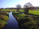
The River Bure is a river
in the county of Norfolk, England, most of it in The Broads
. The Bure rises near Melton Constable
, 11 miles upstream of Aylsham
, which was the original head of navigation. Nowadays, the head of navigation is 10 miles (16.1 km) downstream at Coltishall
Bridge.
After Aylsham Lock and Burgh Bridge, the Bure passes through Buxton Lammas
, Coltishall
, Belaugh
, Wroxham
, Horning
, Ludham Bridge
, past St. Benet's Abbey
, through Oby
, Acle
, Stokesby
, along the northern border of the Halvergate Marshes
, through Runham
and Great Yarmouth
where it meets Breydon Water
and flows into the sea at Gorleston
.
It has two major tributaries, the River Thurne
and the River Ant
. There is also Muck Fleet which connects the Trinity Broads
(Ormesby, Rollesby and Filby Broad) to the main network.
 The River Bure has been navigable for some 31 miles (49.9 km) as far as Horstead Mill, near Coltishall, since at least 1685, when cargoes of coal, corn and timber were carried to within 1 miles (1.6 km) of Meyton manor house. It was stated at the time that the river could be improved to enable boats to reach the house. Vessels could not travel beyond Coltishall, and so Aylsham was served by carts, either loaded from wherries at Coltishall and carried north, or loaded from boats at Cromer and carried south.
Plans to extend the limit of navigation were drawn up in 1773. An Act of Parliament
was obtained on 7 April 1773, authorising improvements from Coltishall to Aylsham, which John Adey estimated would cost £6,000. Some £1,500 had already been raised or promised, and the balance was to be funded by subscriptions. Adey acted as clerk to the Bure Commissioners, while John Smithh was appointed as engineer. Work began on 29 June 1774, and the lock and cut at Coltishall were completed by 16 March 1775, when the first boat used the lock. Progress after that was slow, for in October 1777 Smith announced that he had spent £3,600 so far, but estimated that a further £2,951 would be required to complete the work. It appears that the money had run out, but Smith was persuaded to carry on after 18 traders and landowners provided loans of between £50 and £150. John Green of Wroxham was appointed as joint engineer in March 1779, and the new waterway finally opened in October 1779.
Five locks were provided, at Aylsham, Burgh-near-Aylsham mill, Oxnead mill, Buxton mill at Oxnead Lamas and Coltishall. Within a month, the Commissioners found that silting of the river bed had occurred, reducing the navigable depth, and dredging of the river bed using a scoop, known locally as a didle, was a regular activity. Small wherries, capable of carrying 13 tons, were used for the carriage of flour, agricultural produce, coal and timber. A brickyard at Oxnead was also served by the boats, while below Coltishall, marl
was carried away from pits which were served by a system of navigable dikes on the estate of Horstead Hall. The marl trade continued until 1870, but the dikes remain, in an area called Little Switzerland.
At each of the mills, cuts were made to accommodate the locks, but at Aylsham a longer cut of about 1 miles (1.6 km) was made, ending at a basin where warehouses were constructed. Boats could also get from there to Aylsham mill pool, which enabled them to deliver grain and carry flour away. The navigation was reasonably successful until 1880, when railway competition arrived, in the form of the East Norfolk Railway
, which followed the Bure valley. The East Norfolk later became part of the Great Eastern Railway
. Further competition arrived in 1883, when the Eastern and Midlands Railway opened a station near the terminal basin on its line from Melton Constable to North Walsham. Despite this, wherries were using the navigation until 1912, when a disastrous flood damaged the locks. Assessment of the damage suggested that repairs would cost £4,000, which the Commissioners could not find, and so the navigation was abandoned. This act was formalised in 1928, when it was officially abandoned. Oxnead Lamas lock was filled in in 1933, but the other structures remain, although the lock gates have been replaced by sluices.
River
A river is a natural watercourse, usually freshwater, flowing towards an ocean, a lake, a sea, or another river. In a few cases, a river simply flows into the ground or dries up completely before reaching another body of water. Small rivers may also be called by several other names, including...
in the county of Norfolk, England, most of it in The Broads
The Broads
The Broads are a network of mostly navigable rivers and lakes in the English counties of Norfolk and Suffolk. The Broads, and some surrounding land were constituted as a special area with a level of protection similar to a UK National Park by The Norfolk and Suffolk Broads Act of 1988...
. The Bure rises near Melton Constable
Melton Constable
Melton Constable is a village and civil parish in the English county of Norfolk.It covers an area of and had a population of 518 in 225 households as of the 2001 census.For the purposes of local government, it falls within the district of North Norfolk...
, 11 miles upstream of Aylsham
Aylsham
Aylsham is a historic market town and civil parish on the River Bure in north Norfolk, England, about north of Norwich. The river rises near Melton Constable, upstream from Aylsham and continues to Great Yarmouth and the North Sea, although it was only made navigable after 1779, allowing grain,...
, which was the original head of navigation. Nowadays, the head of navigation is 10 miles (16.1 km) downstream at Coltishall
Coltishall
Coltishall is a village on the River Bure, west of Wroxham, in the English county of Norfolk, within the Norfolk Broads.Coltishall was a place of note even when the Domesday Book was compiled. For 250 years it was a centre of the malting industry...
Bridge.
After Aylsham Lock and Burgh Bridge, the Bure passes through Buxton Lammas
Buxton Lammas
Buxton with Lammas is a civil parish in Broadland in the English county of Norfolk. It comprises the villages of Buxton lying to the west of the River Bure and Lammas on the eastern side of the river. At this point the River Bure is crossed by the Bure Valley Railway on a long girder bridge. ...
, Coltishall
Coltishall
Coltishall is a village on the River Bure, west of Wroxham, in the English county of Norfolk, within the Norfolk Broads.Coltishall was a place of note even when the Domesday Book was compiled. For 250 years it was a centre of the malting industry...
, Belaugh
Belaugh
Belaugh is a small village that occupies a bend in the River Bure in Norfolk, England - within The Broads National Park. It is accessible via the road between Hoveton and Coltishall or from the river. It contains no pubs, bars or shops...
, Wroxham
Wroxham
Wroxham is a village and civil parish in the English county of Norfolk. The civil parish of Wroxham has an area of 6.21 square kilometres and in 2001 had a population of 1532 in 666 households. The village is situated within the Norfolk Broads on the south side of a loop in the middle reaches of...
, Horning
Horning
Horning is an ancient village and parish in the English county of Norfolk.It covers an area of 11 km2 and had a population of 1,033 in the 2001 census. Horning parish lies on the northern bank of the River Bure south of the River Thurne and is located in the The Broads National Park...
, Ludham Bridge
Ludham Bridge
Ludham Bridge is a hamlet on the River Ant on the Norfolk Broads in Norfolk, England....
, past St. Benet's Abbey
St. Benet's Abbey
St Benet's Abbey is a ruined abbey of the Order of Saint Benedict situated on the River Bure within The Broads in Norfolk England. It is also known as St Benet's at Holme or Hulme.-Background:...
, through Oby
Ashby with Oby
Ashby with Oby is a civil parish in the English county of Norfolk, which is located some north of Acle and north-west of Great Yarmouth. The parish largely comprises scattered farms, and is named for the tiny settlements of Ashby and Oby....
, Acle
Acle
Acle is a small market town on the River Bure on The Norfolk Broads in Norfolk, located halfway between Norwich and Great Yarmouth. It has the only bridge across the River Bure between Wroxham and Great Yarmouth. There is a high school Acle is a small market town on the River Bure on The Norfolk...
, Stokesby
Stokesby with Herringby
Stokesby with Herringby is a civil parish in the English county of Norfolk. It comprises the village of Stokesby and the surrounding rural area. It is situated on the banks of the River Bure, some 10 km west of the town of Great Yarmouth and 25 km east of the city of Norwich.The civil parish has an...
, along the northern border of the Halvergate Marshes
Halvergate Marshes
The Halvergate Marshes are marshes situated south of the River Bure on the Norfolk Broads in Norfolk, England, United Kingdom.Halvergate Marshes were an estuary in Roman times. Around 400 years ago the land was drained and converted to grazing marsh...
, through Runham
Mautby
Mautby is a civil parish in the English county of Norfolk. The parish comprises a largely rural area along the north bank of the River Bure, and includes the small villages of Mautby, Runham and Thrigby...
and Great Yarmouth
Great Yarmouth
Great Yarmouth, often known to locals as Yarmouth, is a coastal town in Norfolk, England. It is at the mouth of the River Yare, east of Norwich.It has been a seaside resort since 1760, and is the gateway from the Norfolk Broads to the sea...
where it meets Breydon Water
Breydon Water
Breydon Water is a massive stretch of sheltered estuary at Great Yarmouth in Norfolk, England. It is at gateway to the Norfolk Broads. It is the UK's largest protected wetland. It is 5 km long and more than 1.5 km wide in places...
and flows into the sea at Gorleston
Gorleston
Gorleston-On-Sea, also known colloquially as Gorleston, is a settlement in Norfolk in the United Kingdom, forming part of the larger town of Great Yarmouth. Situated at the mouth of the River Yare it was a port town at the time of the Domesday Book. The port then became a centre of fishing for...
.
It has two major tributaries, the River Thurne
River Thurne
The River Thurne is a river in Norfolk, England in The Broads. Just six miles long it rises two miles from the coast near Martham Broad and is navigable from West Somerton. It flows southwest and is linked by Candle Dyke and Heigham Sound to both Horsey Mere and Hickling Broad...
and the River Ant
River Ant
The River Ant is a tributary river of the River Bure in the county of Norfolk, England. It is 17 miles long , and has an overall drop of 25 metres from source to mouth...
. There is also Muck Fleet which connects the Trinity Broads
Trinity Broads
The Trinity Broads are part of the Broads National Park in Norfolk, England, comprising 5 broads in total. The three largest are Rollesby Broad, Ormesby Broad and Filby Broad, and there are two much smaller broads named Lily Broad and Ormesby Little Broad...
(Ormesby, Rollesby and Filby Broad) to the main network.
History
Plans to extend the limit of navigation were drawn up in 1773. An Act of Parliament
Act of Parliament
An Act of Parliament is a statute enacted as primary legislation by a national or sub-national parliament. In the Republic of Ireland the term Act of the Oireachtas is used, and in the United States the term Act of Congress is used.In Commonwealth countries, the term is used both in a narrow...
was obtained on 7 April 1773, authorising improvements from Coltishall to Aylsham, which John Adey estimated would cost £6,000. Some £1,500 had already been raised or promised, and the balance was to be funded by subscriptions. Adey acted as clerk to the Bure Commissioners, while John Smithh was appointed as engineer. Work began on 29 June 1774, and the lock and cut at Coltishall were completed by 16 March 1775, when the first boat used the lock. Progress after that was slow, for in October 1777 Smith announced that he had spent £3,600 so far, but estimated that a further £2,951 would be required to complete the work. It appears that the money had run out, but Smith was persuaded to carry on after 18 traders and landowners provided loans of between £50 and £150. John Green of Wroxham was appointed as joint engineer in March 1779, and the new waterway finally opened in October 1779.
Five locks were provided, at Aylsham, Burgh-near-Aylsham mill, Oxnead mill, Buxton mill at Oxnead Lamas and Coltishall. Within a month, the Commissioners found that silting of the river bed had occurred, reducing the navigable depth, and dredging of the river bed using a scoop, known locally as a didle, was a regular activity. Small wherries, capable of carrying 13 tons, were used for the carriage of flour, agricultural produce, coal and timber. A brickyard at Oxnead was also served by the boats, while below Coltishall, marl
Marl
Marl or marlstone is a calcium carbonate or lime-rich mud or mudstone which contains variable amounts of clays and aragonite. Marl was originally an old term loosely applied to a variety of materials, most of which occur as loose, earthy deposits consisting chiefly of an intimate mixture of clay...
was carried away from pits which were served by a system of navigable dikes on the estate of Horstead Hall. The marl trade continued until 1870, but the dikes remain, in an area called Little Switzerland.
At each of the mills, cuts were made to accommodate the locks, but at Aylsham a longer cut of about 1 miles (1.6 km) was made, ending at a basin where warehouses were constructed. Boats could also get from there to Aylsham mill pool, which enabled them to deliver grain and carry flour away. The navigation was reasonably successful until 1880, when railway competition arrived, in the form of the East Norfolk Railway
East Norfolk Railway
The East Norfolk Railway was a standard gauge 25 mile, mostly single track, railway running between Norwich Thorpe railway station and Cromer in the English county of Norfolk. It opened in 1874, reaching Cromer three years later, and remains mostly operational...
, which followed the Bure valley. The East Norfolk later became part of the Great Eastern Railway
Great Eastern Railway
The Great Eastern Railway was a pre-grouping British railway company, whose main line linked London Liverpool Street to Norwich and which had other lines through East Anglia...
. Further competition arrived in 1883, when the Eastern and Midlands Railway opened a station near the terminal basin on its line from Melton Constable to North Walsham. Despite this, wherries were using the navigation until 1912, when a disastrous flood damaged the locks. Assessment of the damage suggested that repairs would cost £4,000, which the Commissioners could not find, and so the navigation was abandoned. This act was formalised in 1928, when it was officially abandoned. Oxnead Lamas lock was filled in in 1933, but the other structures remain, although the lock gates have been replaced by sluices.
See also
- Bure Valley RailwayBure Valley RailwayThe Bure Valley Railway is a minimum gauge heritage railway in Norfolk, within The Broads National Park.The railway runs from Wroxham to Aylsham and is Norfolk's longest railway of less than standard gauge. It uses both steam and diesel locomotives. There are intermediate halts at Brampton,...
, a heritage railwayHeritage railwaythumb|right|the Historical [[Khyber train safari|Khyber Railway]] goes through the [[Khyber Pass]], [[Pakistan]]A heritage railway , preserved railway , tourist railway , or tourist railroad is a railway that is run as a tourist attraction, in some cases by volunteers, and... - Bure Valley PathBure Valley PathThe Bure Valley Path is a long walking trail and cycling trail in Norfolk, England. It runs alongside the Bure Valley Railway, a heritage railway from Wroxham to Aylsham.- Route :The path passes through and close to following towns and villages.* Aylsham...
- Bure Marshes NNRBure Marshes NNRBure Marshes National Nature Reserve is maintained by English Nature in Norfolk, England, within The Broads National Park.It is mostly fen land and includes four Broads which are disused peat workings dug between 900 and 1350:...
- National Nature ReserveNational Nature ReserveFor details of National nature reserves in the United Kingdom see:*National Nature Reserves in England*National Nature Reserves in Northern Ireland*National Nature Reserves in Scotland*National Nature Reserves in Wales... - Bure (HM Prison)Bure (HM Prison)HM Prison Bure is a Category C men's prison, located in the parish of Badersfield in Norfolk, England. The prison is operated by Her Majesty's Prison Service, and became operational in November 2009.-History:...
, a Category CPrison security categories in the United KingdomThere are four prisoner security categories in the United Kingdom used to classify every adult prisoner for the purposes of assigning them to a prison. The categories are based upon the severity of the crime and the risk posed should the person escape....
men's prisonPrisonA prison is a place in which people are physically confined and, usually, deprived of a range of personal freedoms. Imprisonment or incarceration is a legal penalty that may be imposed by the state for the commission of a crime...
in ScottowScottowScottow is a village and civil parish in the English county of Norfolk. It is located some north of Coltishall and south of North Walsham.The civil parish has an area of and in 2001 had a population of 1,774 in 357 households...
, NorfolkNorfolkNorfolk is a low-lying county in the East of England. It has borders with Lincolnshire to the west, Cambridgeshire to the west and southwest and Suffolk to the south. Its northern and eastern boundaries are the North Sea coast and to the north-west the county is bordered by The Wash. The county...
. Named after the river