

River Ant
Encyclopedia
The River Ant is a tributary river of the River Bure
in the county of Norfolk
, England. It is 17 miles long (of which 8.75 miles are now navigable), and has an overall drop of 25 metres from source to mouth. It is said that the Ant was formerly known as the River Smale and that this is the origin of the name of the village of Smallburgh
.
The river's source is just east of the village of Antingham
in North Norfolk
at Antingham Ponds. Just below the pools the river's route has been used as a canal
in the past, starting at what was Antingham bone mill. An Act of Parliament
established the North Walsham & Dilham Canal
in 1812, as a wide gauge canal able to take a Norfolk wherry
. It was built at a cost of £30,000 and opened on July 25, 1826, making the river navigable as far as Dilham
, where the river widens and deepens. It carried manure, offal, flour, coal, and farm produce. In 1885, the canal was sold for £600, but the canal company's solicitor disappeared with the money. The flood of 1912 washed away several staithes. The wherry "Ella" made the final trading journey on the canal from Bacton
staithe in 1934. The canal was never nationalised and still belongs to the North Walsham
Canal Company. The river, now in its canal form, curves around the north east of the town of North Walsham
passing Bacton Wood Mill. Below Bacton Mill the canal reaches a lock at Ebridge mill. The lock is in poor condition but it is hoped that this section of canal will one day be restored and made navigable again. Further on at Briggate Bridge there is another mill and another disused lock.
Bridge the course enters the The Broads
, administered by The Broads Authority
. Here the canal cuts through a marshy wooded area called Dilham Broad and again curves north east around the village of Dilham
, passing under Tonnage Bridge. Below Tonnage Bridge are the last limits of the Navigation
through Broad Fen before reverting back to the river. Just before Wayford Bridge, a branch of the canal
called Tyler’s Cut runs off to the west. This branch links the villages of Dilham
and Smallburgh
to the river and the rest of the broads although it is at the moment only navigable by very small boats. At Wayford Bridge
the river passes the Wayford Bridge Hotel and its row of tiny houseboats lining the east bank of the river. There is only 8 feet of headroom under the bridge, which carries the A149 road
, and the river is only three feet deep at this point, making it only passable by the smallest of pleasure craft. Some years ago the ancient hard surface of the ‘ford
’ which gave rise to the name “Wayford” was found on the river bed here. Just the other side of the bridge there are boat yards on both banks and the river follows a fairly straight course until it reaches the photogenic “Hunsett Drainage Mill
”. Here, where the river turns south and passes the channel leading to the staithes at Stalham and Sutton, the river banks of Barton Fen are crowded with trees, marshes, and reeds
, the latter formerly harvested and used for thatching for centuries past.
 As the river nears Barton Broad
it passes a triangular island called the Heater. The channels either side lead to Barton Turf staithe and its boatyard. The river now enters Barton Broad
, the second largest of the Broads. Its crystal clear waters are the result of considerable effort and money spent to clean the broad up over the last few years. Barton Broad is unique in that it has an island, called “Pleasure Hill”.
. The river meanders through the flat Broadland countryside, passing the drainage mills
of Clayrack
and Broadman’s on the east bank, and Turf Fen Drainage
mill on the west bank. Here the river passes How Hill
nature reserve, which is open to the public. From here it makes a wide horseshoe bend, passing Neaves Drainage
mill as it heads towards Ludham
Bridge. The Ant passes under the bridge carrying the A1062 road, and turns sharply east before straightening out a little. It then turns south and enters the river Bure at Ant Mouth, close to the ruins of St Benet’s Abbey.
in August 2010 when working on the river during vital flood defence work. The boat, around 3 m (9.8 ft) long, had been hollowed out by hand from a single piece of oak
and was found at the bottom of the river between Horning
Hall and Brown's Hill. Five animal skulls were found near the boat, which was taken to specialists in York
to be treated with special preservatives. Once the treatment has been completed the boat will be delivered to the Castle Museum in Norwich
and put on display to the public.
was used on the Ant, measuring 50' x 12' max.
The Ant Broads & Marshes NNR
is a National Nature Reserve
.
The North Walsham & Dilham Canal
is the canalisation of the Ant and joins it at Smallburgh
junction.
River Bure
The River Bure is a river in the county of Norfolk, England, most of it in The Broads. The Bure rises near Melton Constable, upstream of Aylsham, which was the original head of navigation. Nowadays, the head of navigation is downstream at Coltishall Bridge...
in the county of Norfolk
Norfolk
Norfolk is a low-lying county in the East of England. It has borders with Lincolnshire to the west, Cambridgeshire to the west and southwest and Suffolk to the south. Its northern and eastern boundaries are the North Sea coast and to the north-west the county is bordered by The Wash. The county...
, England. It is 17 miles long (of which 8.75 miles are now navigable), and has an overall drop of 25 metres from source to mouth. It is said that the Ant was formerly known as the River Smale and that this is the origin of the name of the village of Smallburgh
Smallburgh
Smallburgh is a village and a civil parish in the English county of Norfolk. The village is fourteen miles south-east of Cromer, fourteen miles north-east of Norwich and north-east of London. The village lies five miles south-east of the nearby town of North Walsham...
.
The river's source is just east of the village of Antingham
Antingham
Antingham is a village and civil parish in the north of the English county of Norfolk. The village is located about south of Cromer and north of North Walsham...
in North Norfolk
North Norfolk
North Norfolk is a local government district in Norfolk, United Kingdom. Its council is based in Cromer. The council headquarters can be found approximately out of the town of Cromer on the Holt Road.-History:...
at Antingham Ponds. Just below the pools the river's route has been used as a canal
Canal
Canals are man-made channels for water. There are two types of canal:#Waterways: navigable transportation canals used for carrying ships and boats shipping goods and conveying people, further subdivided into two kinds:...
in the past, starting at what was Antingham bone mill. An Act of Parliament
Parliament of the United Kingdom
The Parliament of the United Kingdom of Great Britain and Northern Ireland is the supreme legislative body in the United Kingdom, British Crown dependencies and British overseas territories, located in London...
established the North Walsham & Dilham Canal
North Walsham & Dilham Canal
The North Walsham and Dilham Canal is a waterway in the English county of Norfolk. It is accepted officially that this waterway is the only canal in Norfolk although it is the canalization of the upper reaches of the River Ant. This navigation was constructed with locks a little wider than most...
in 1812, as a wide gauge canal able to take a Norfolk wherry
Wherry
A wherry is a type of boat that was traditionally used for carrying cargo or passengers on rivers and canals in England, and is particularly associated with the River Thames and also with the Broadland rivers of Norfolk and Suffolk. London passenger wherries evolved into the Thames skiff, a...
. It was built at a cost of £30,000 and opened on July 25, 1826, making the river navigable as far as Dilham
Dilham
Dilham is a village and civil parish covering an area of with a population of 301 in 128 homes as of the 2001 census. It is on the River Ant just of the A149 road, near Stalham in Norfolk, England within The Broads...
, where the river widens and deepens. It carried manure, offal, flour, coal, and farm produce. In 1885, the canal was sold for £600, but the canal company's solicitor disappeared with the money. The flood of 1912 washed away several staithes. The wherry "Ella" made the final trading journey on the canal from Bacton
Bacton, Norfolk
Bacton is a village and civil parish in Norfolk, England. It is on the Norfolk coast, some 20 km south-east of Cromer, 40 km north-west of Great Yarmouth and 30 km north of Norwich. Besides the village of Bacton, the parish includes the nearby settlements of Bacton Green, Broomholm,...
staithe in 1934. The canal was never nationalised and still belongs to the North Walsham
North Walsham
North Walsham is a market town and civil parish in Norfolk, England in the North Norfolk district.-Demographics:The civil parish has an area of and in the 2001 census had a population of 11,998. For the purposes of local government, the parish falls within the district of North...
Canal Company. The river, now in its canal form, curves around the north east of the town of North Walsham
North Walsham
North Walsham is a market town and civil parish in Norfolk, England in the North Norfolk district.-Demographics:The civil parish has an area of and in the 2001 census had a population of 11,998. For the purposes of local government, the parish falls within the district of North...
passing Bacton Wood Mill. Below Bacton Mill the canal reaches a lock at Ebridge mill. The lock is in poor condition but it is hoped that this section of canal will one day be restored and made navigable again. Further on at Briggate Bridge there is another mill and another disused lock.
Norfolk Broads (The Broads Authority)
At HoningHoning, Norfolk
Honing is a village and a civil parish in the English county of Norfolk. The village is north-northeast of Norwich, south east of Cromer and north-east of London. The village lies east of the town of North Walsham. The nearest railway station is at Worstead on the Bittern Line which runs...
Bridge the course enters the The Broads
The Broads
The Broads are a network of mostly navigable rivers and lakes in the English counties of Norfolk and Suffolk. The Broads, and some surrounding land were constituted as a special area with a level of protection similar to a UK National Park by The Norfolk and Suffolk Broads Act of 1988...
, administered by The Broads Authority
Broads Authority
The Broads Authority is the agency which has statutory responsibility for the Broads in England. Originally, the Nature Conservancy Council , pressed for a special authority to manage the Broads which had been neglected for a long time. In 1978, the forerunner to the present-day Broads Authority...
. Here the canal cuts through a marshy wooded area called Dilham Broad and again curves north east around the village of Dilham
Dilham
Dilham is a village and civil parish covering an area of with a population of 301 in 128 homes as of the 2001 census. It is on the River Ant just of the A149 road, near Stalham in Norfolk, England within The Broads...
, passing under Tonnage Bridge. Below Tonnage Bridge are the last limits of the Navigation
Navigation
Navigation is the process of monitoring and controlling the movement of a craft or vehicle from one place to another. It is also the term of art used for the specialized knowledge used by navigators to perform navigation tasks...
through Broad Fen before reverting back to the river. Just before Wayford Bridge, a branch of the canal
Canal
Canals are man-made channels for water. There are two types of canal:#Waterways: navigable transportation canals used for carrying ships and boats shipping goods and conveying people, further subdivided into two kinds:...
called Tyler’s Cut runs off to the west. This branch links the villages of Dilham
Dilham
Dilham is a village and civil parish covering an area of with a population of 301 in 128 homes as of the 2001 census. It is on the River Ant just of the A149 road, near Stalham in Norfolk, England within The Broads...
and Smallburgh
Smallburgh
Smallburgh is a village and a civil parish in the English county of Norfolk. The village is fourteen miles south-east of Cromer, fourteen miles north-east of Norwich and north-east of London. The village lies five miles south-east of the nearby town of North Walsham...
to the river and the rest of the broads although it is at the moment only navigable by very small boats. At Wayford Bridge
Wayford Bridge
Wayford Bridge is a village on the River Ant on the A149 road, near Stalham in Norfolk, England within The Broads National Park.Due to height restrictions under the road bridge it is the most northerly point of navigation on the Norfolk Broads for boats over Wayford Bridge is a village on the River...
the river passes the Wayford Bridge Hotel and its row of tiny houseboats lining the east bank of the river. There is only 8 feet of headroom under the bridge, which carries the A149 road
A149 road
The A149 is a major route in Norfolk, linking Kings Lynn to Great Yarmouth. It runs via the coast rather than on a more direct route such as the A47. The eastern section runs through The Broads.-Kings Lynn to Wells next the Sea:...
, and the river is only three feet deep at this point, making it only passable by the smallest of pleasure craft. Some years ago the ancient hard surface of the ‘ford
Ford (crossing)
A ford is a shallow place with good footing where a river or stream may be crossed by wading or in a vehicle. A ford is mostly a natural phenomenon, in contrast to a low water crossing, which is an artificial bridge that allows crossing a river or stream when water is low.The names of many towns...
’ which gave rise to the name “Wayford” was found on the river bed here. Just the other side of the bridge there are boat yards on both banks and the river follows a fairly straight course until it reaches the photogenic “Hunsett Drainage Mill
Hunsett Windmill
Hunsett Mill is located on the east bank of the River Ant one mile north of Barton Broad in the English county of Norfolk. The Windmill is 1.2 miles south west of the town of Stalham. The mill structure is a grade II listed building.-Description:...
”. Here, where the river turns south and passes the channel leading to the staithes at Stalham and Sutton, the river banks of Barton Fen are crowded with trees, marshes, and reeds
Phragmites
Phragmites, the Common reed, is a large perennial grass found in wetlands throughout temperate and tropical regions of the world. Phragmites australis is sometimes regarded as the sole species of the genus Phragmites, though some botanists divide Phragmites australis into three or four species...
, the latter formerly harvested and used for thatching for centuries past.
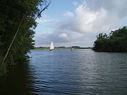
Barton Broad
Barton Broad
Barton Broad lies within The Broads in Norfolk, the United Kingdom. The broad is situated to the south and east of the village of Barton Turf, and is within the parish of Barton Turf....
it passes a triangular island called the Heater. The channels either side lead to Barton Turf staithe and its boatyard. The river now enters Barton Broad
Barton Broad
Barton Broad lies within The Broads in Norfolk, the United Kingdom. The broad is situated to the south and east of the village of Barton Turf, and is within the parish of Barton Turf....
, the second largest of the Broads. Its crystal clear waters are the result of considerable effort and money spent to clean the broad up over the last few years. Barton Broad is unique in that it has an island, called “Pleasure Hill”.
The last stretch
The Ant leaves Barton Broad at its south east corner and enters a stretch called “The Shoals”. All around this area can be seen numerous drainage millsWindpump
A windpump is a windmill used for pumping water, either as a source of fresh water from wells, or for draining low-lying areas of land. Once a common fixture on farms in semi-arid areas, windpumps are still used today where electric power is not available or too expensive.-History:Windmills were...
. The river meanders through the flat Broadland countryside, passing the drainage mills
Windpump
A windpump is a windmill used for pumping water, either as a source of fresh water from wells, or for draining low-lying areas of land. Once a common fixture on farms in semi-arid areas, windpumps are still used today where electric power is not available or too expensive.-History:Windmills were...
of Clayrack
Clayrack Drainage Mill
Clayrack Drainage Windmill is located at How Hill in the English county of Norfolk . It is on the east bank of the River Ant close to How Hill House, a large Edwardian building which houses the Norfolk Broads Study Centre...
and Broadman’s on the east bank, and Turf Fen Drainage
Drainage
Drainage is the natural or artificial removal of surface and sub-surface water from an area. Many agricultural soils need drainage to improve production or to manage water supplies.-Early history:...
mill on the west bank. Here the river passes How Hill
How Hill
How Hill lies on the River Ant within The Broads National Park in Norfolk, England.The large Edwardian building houses the Norfolk Broads Study Centre, an independent charitable organisation which runs residential environmental courses for groups of schoolchildren.The How Hill Nature Reserve is...
nature reserve, which is open to the public. From here it makes a wide horseshoe bend, passing Neaves Drainage
Drainage
Drainage is the natural or artificial removal of surface and sub-surface water from an area. Many agricultural soils need drainage to improve production or to manage water supplies.-Early history:...
mill as it heads towards Ludham
Ludham
Ludham is a village and civil parish in the English county of Norfolk, in The Broads, at the end of a dyke leading to Womack Water and flowing into the River Thurne...
Bridge. The Ant passes under the bridge carrying the A1062 road, and turns sharply east before straightening out a little. It then turns south and enters the river Bure at Ant Mouth, close to the ruins of St Benet’s Abbey.
Saxon discovery
The remains of a Saxon boat were found by the Environment AgencyEnvironment Agency
The Environment Agency is a British non-departmental public body of the Department for Environment, Food and Rural Affairs and an Assembly Government Sponsored Body of the Welsh Assembly Government that serves England and Wales.-Purpose:...
in August 2010 when working on the river during vital flood defence work. The boat, around 3 m (9.8 ft) long, had been hollowed out by hand from a single piece of oak
Oak
An oak is a tree or shrub in the genus Quercus , of which about 600 species exist. "Oak" may also appear in the names of species in related genera, notably Lithocarpus...
and was found at the bottom of the river between Horning
Horning
Horning is an ancient village and parish in the English county of Norfolk.It covers an area of 11 km2 and had a population of 1,033 in the 2001 census. Horning parish lies on the northern bank of the River Bure south of the River Thurne and is located in the The Broads National Park...
Hall and Brown's Hill. Five animal skulls were found near the boat, which was taken to specialists in York
York
York is a walled city, situated at the confluence of the Rivers Ouse and Foss in North Yorkshire, England. The city has a rich heritage and has provided the backdrop to major political events throughout much of its two millennia of existence...
to be treated with special preservatives. Once the treatment has been completed the boat will be delivered to the Castle Museum in Norwich
Norwich
Norwich is a city in England. It is the regional administrative centre and county town of Norfolk. During the 11th century, Norwich was the largest city in England after London, and one of the most important places in the kingdom...
and put on display to the public.
Facts
A special type of Norfolk wherryNorfolk wherry
The Norfolk wherry is a type of boat on The Broads in Norfolk, England. Three main types were developed over its life, all featuring the distinctive gaff rig with a single, high-peaked sail and the mast stepped well forward.-Development of the wherry:...
was used on the Ant, measuring 50' x 12' max.
The Ant Broads & Marshes NNR
Ant Broads & Marshes NNR
Ant Broads & Marshes NNR is a National Nature Reserve in Norfolk, England established by English Nature. It is named after the River Ant.It is part of the "Ant Broads and Marshes" Site of Special Scientific Interest and is within The Broads National Park....
is a National Nature Reserve
National Nature Reserve
For details of National nature reserves in the United Kingdom see:*National Nature Reserves in England*National Nature Reserves in Northern Ireland*National Nature Reserves in Scotland*National Nature Reserves in Wales...
.
The North Walsham & Dilham Canal
North Walsham & Dilham Canal
The North Walsham and Dilham Canal is a waterway in the English county of Norfolk. It is accepted officially that this waterway is the only canal in Norfolk although it is the canalization of the upper reaches of the River Ant. This navigation was constructed with locks a little wider than most...
is the canalisation of the Ant and joins it at Smallburgh
Smallburgh
Smallburgh is a village and a civil parish in the English county of Norfolk. The village is fourteen miles south-east of Cromer, fourteen miles north-east of Norwich and north-east of London. The village lies five miles south-east of the nearby town of North Walsham...
junction.