
Dilham
Encyclopedia
Dilham is a village
and civil parish covering an area of 6.55 km² (2.5 sq mi) with a population of 301 in 128 homes as of the 2001 census
. It is on the River Ant
just of the A149 road
, near Stalham
in Norfolk, England within The Broads
. The name comes from the extensive fields of dill
, a herb which was grown commercially here.
 It is the limit of Broads navigation for larger boats, but small boats, and especially non-powered boats, can travel on the North Walsham & Dilham Canal
until Honing
.
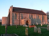
Its church, St Nicholas, is one of 124 existing round-tower church
es in Norfolk
. Attached to the nearby Dilham Hall is a fifteenth century tower, all that remains of Dilham Castle
, a fifteenth century fortified house.
Village
A village is a clustered human settlement or community, larger than a hamlet with the population ranging from a few hundred to a few thousand , Though often located in rural areas, the term urban village is also applied to certain urban neighbourhoods, such as the West Village in Manhattan, New...
and civil parish covering an area of 6.55 km² (2.5 sq mi) with a population of 301 in 128 homes as of the 2001 census
United Kingdom Census 2001
A nationwide census, known as Census 2001, was conducted in the United Kingdom on Sunday, 29 April 2001. This was the 20th UK Census and recorded a resident population of 58,789,194....
. It is on the River Ant
River Ant
The River Ant is a tributary river of the River Bure in the county of Norfolk, England. It is 17 miles long , and has an overall drop of 25 metres from source to mouth...
just of the A149 road
A149 road
The A149 is a major route in Norfolk, linking Kings Lynn to Great Yarmouth. It runs via the coast rather than on a more direct route such as the A47. The eastern section runs through The Broads.-Kings Lynn to Wells next the Sea:...
, near Stalham
Stalham
Stalham is a market town on the River Ant in the English county of Norfolk, in East Anglia. It covers an area of and had a population of 2,951 in 1,333 households as of the 2001 census. It lies within the Norfolk Broads, about north-east of Norwich on the A149 road.For the purposes of local...
in Norfolk, England within The Broads
The Broads
The Broads are a network of mostly navigable rivers and lakes in the English counties of Norfolk and Suffolk. The Broads, and some surrounding land were constituted as a special area with a level of protection similar to a UK National Park by The Norfolk and Suffolk Broads Act of 1988...
. The name comes from the extensive fields of dill
Dill
Dill is a perennial herb. It is the sole species of the genus Anethum, though classified by some botanists in a related genus as Peucedanum graveolens C.B.Clarke.-Growth:...
, a herb which was grown commercially here.
North Walsham & Dilham Canal
The North Walsham and Dilham Canal is a waterway in the English county of Norfolk. It is accepted officially that this waterway is the only canal in Norfolk although it is the canalization of the upper reaches of the River Ant. This navigation was constructed with locks a little wider than most...
until Honing
Honing, Norfolk
Honing is a village and a civil parish in the English county of Norfolk. The village is north-northeast of Norwich, south east of Cromer and north-east of London. The village lies east of the town of North Walsham. The nearest railway station is at Worstead on the Bittern Line which runs...
.
Its church, St Nicholas, is one of 124 existing round-tower church
Round-tower church
Round-tower churches are a type of church found mainly in England, almost solely in East Anglia; of about 185 surviving examples in the country, 124 are in Norfolk, 38 in Suffolk, 6 in Essex, 3 in Sussex and 2 each in Cambridgeshire and Berkshire. There is evidence of about twenty round-tower...
es in Norfolk
Norfolk
Norfolk is a low-lying county in the East of England. It has borders with Lincolnshire to the west, Cambridgeshire to the west and southwest and Suffolk to the south. Its northern and eastern boundaries are the North Sea coast and to the north-west the county is bordered by The Wash. The county...
. Attached to the nearby Dilham Hall is a fifteenth century tower, all that remains of Dilham Castle
Dilham Castle
Dilham Castle, also called Dilham Hall, is situated in the village of Dilham, near Stalham in Norfolk, England.-Details:Dilham Castle was built in the 15th century by Sir Henry Inglose, probably around the same time as nearby Caister Castle. Inglose had served in France under Henry V and was a...
, a fifteenth century fortified house.