
A148 road
Encyclopedia

England
England is a country that is part of the United Kingdom. It shares land borders with Scotland to the north and Wales to the west; the Irish Sea is to the north west, the Celtic Sea to the south west, with the North Sea to the east and the English Channel to the south separating it from continental...
A road entirely in the county
County
A county is a jurisdiction of local government in certain modern nations. Historically in mainland Europe, the original French term, comté, and its equivalents in other languages denoted a jurisdiction under the sovereignty of a count A county is a jurisdiction of local government in certain...
of Norfolk
Norfolk
Norfolk is a low-lying county in the East of England. It has borders with Lincolnshire to the west, Cambridgeshire to the west and southwest and Suffolk to the south. Its northern and eastern boundaries are the North Sea coast and to the north-west the county is bordered by The Wash. The county...
. It runs from King's Lynn
King's Lynn
King's Lynn is a sea port and market town in the ceremonial county of Norfolk in the East of England. It is situated north of London and west of Norwich. The population of the town is 42,800....
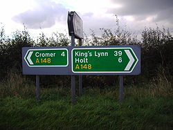
to Cromer
Cromer
Cromer is a coastal town and civil parish in north Norfolk, England. The local government authority is North Norfolk District Council, whose headquarters is in Holt Road in the town. The town is situated 23 miles north of the county town, Norwich, and is 4 miles east of Sheringham...
via Fakenham
Fakenham
Fakenham is a town and civil parish in Norfolk, England. It is situated on the River Wensum, some north east of King's Lynn, south west of Cromer, and north west of Norwich....
which it bypasses to the north.
King’s Lynn starting point
A47 road
The A47 is a trunk road in England originally linking Birmingham to Great Yarmouth. Most of the section between Birmingham and Nuneaton is now classified as the B4114.-Route:...
. It runs in a northerly direction through the King’s Lynn suburb of South Lynn as Saddlebow Road. In just over 1/2 mi the road becomes Wisbech
Wisbech
Wisbech is a market town, inland port and civil parish with a population of 20,200 in the Fens of Cambridgeshire. The tidal River Nene runs through the centre of the town and is spanned by two bridges...
Road and crosses the River Nar
River Nar
The River Nar is a river in England, and tributary of the River Great Ouse. It rises near Litcham in Norfolk and flows 15 miles west through Castle Acre and Narborough , joining the Ouse at King's Lynn. It has had a variety of alternative names, such as the Setch, the Sandringham, and Lynn Flu,...
. The road now joins a roundabout at the bottom end of King's Lynn. At this roundabout the A149
A149 road
The A149 is a major route in Norfolk, linking Kings Lynn to Great Yarmouth. It runs via the coast rather than on a more direct route such as the A47. The eastern section runs through The Broads.-Kings Lynn to Wells next the Sea:...
, Hardwick Road, runs of to the right whilst the B1144 is straight across the island and runs around the eastern skirt of the town. The A148 turns right and northward and is now called London
London
London is the capital city of :England and the :United Kingdom, the largest metropolitan area in the United Kingdom, and the largest urban zone in the European Union by most measures. Located on the River Thames, London has been a major settlement for two millennia, its history going back to its...
Road and the road soon passes under the South Gate of what were once the defences of the town. This Gateway was built in the Reign of Edward III. It is brick built with stone surrounds to the arches. The gate only straddles the northbound carriage way, and was restored at a cost of £80,000 in 1982. The road now takes a route through the heart of King's Lynn as St James Road and after 1.3 miles (2.1 km) enters a one way system as Railway Road. At 1.5 miles (2.4 km) the road turns right into Austin Road and at its junction
Junction (traffic)
A junction, when discussed in the context of transport, is a location where traffic can change between different routes, directions, or sometimes modes, of travel.-Historical significance:...
with Littleport Road it reverts to a two way carriageway again, and after a short distance crosses a bridge over the Gaywood River
Gaywood River
Gaywood River is a tributary of the River Great Ouse in the west of the county of Norfolk. Its source is 11 metres above sea level, northwest of the village of Gayton in Derby Fen, Map Reference TF 705 209...
and becomes Gaywood Road. The road soon passes the King Edward VII School on the right and on out into the Suburb of Gaywood. Gaywood road then becomes Lynn Road and now after 2.5 miles (4 km) from the start the road takes a left turn into Wooton Road. The road direction is now to the north east towards South Wooton. At 3.8 miles (6.1 km) the road comes to a 'T' Junction controlled by traffic lights. From the left is the A1078 which terminates at this junction and two the right the A148 continues on its way out of King's Lynn. Now Grimston Road, the road inclines towards a large roundabout.
King’s Lynn to Hillington
It is now 5.3 miles (8.5 km) since the start and the roundabout is the junction with the A149A149 road
The A149 is a major route in Norfolk, linking Kings Lynn to Great Yarmouth. It runs via the coast rather than on a more direct route such as the A47. The eastern section runs through The Broads.-Kings Lynn to Wells next the Sea:...
Queen Elizabeth Way. The A148 continues on over the roundabout now signposted to Fakenham and Cromer. The road is now characterized by long straights through dense woodland on both sides of the carriageway. After 8.4 miles (13.5 km) the road crosses the River Cong
River Cong (Norfolk)
The River Cong is in the west of the county of Norfolk. Its is a tributary of the River Babingley. The spring rises in a meadow pool on the Hillington side of Manor Farm, Congham...
, and a turning on the left which is the B1440 to Sandringham
Sandringham, Norfolk
Sandringham is a village and civil parish in the north of the English county of Norfolk. The village is situated some south of the village of Dersingham, north of the town of King's Lynn and north-west of the city of Norwich....
and the Royal Estate
Sandringham House
Sandringham House is a country house on of land near the village of Sandringham in Norfolk, England. The house is privately owned by the British Royal Family and is located on the royal Sandringham Estate, which lies within the Norfolk Coast Area of Outstanding Natural Beauty.-History and current...
there. At 8.5 miles (13.7 km) the village of Hillington
Hillington, Norfolk
Hillington is a civil parish in the English county of Norfolk.It covers an area of and had a population of 287 in 123 households as of the 2001 census.For the purposes of local government, it falls within the district of King's Lynn and West Norfolk....
is reached. On the left as you enter the village is a filling station and the three hundred year old coaching inn
Coaching inn
In Europe, from approximately the mid-17th century for a period of about 200 years, the coaching inn, sometimes called a coaching house or staging inn, was a vital part of the inland transport infrastructure, as an inn serving coach travelers...
called the Ffolkes Arms Hotel. Many years ago the attic rooms of this Inn were used to lock up prisoners overnight who were being transported to Norwich Prison. 100 yards (91.4 m) further on from the hotel is the gatehouse entrance to Hillington Hall. This estate once extended over 8000 acres (32.4 km²) of the Norfolk Countryside and was the home Ffolkes family who purchased it in 1678. The purchaser was Martin Ffolkes who was the Attorney-General to Queen Catherine
Catherine of Braganza
Catherine of Braganza was a Portuguese infanta and queen consort of England, Scotland and Ireland as the wife of King Charles II.She married the king in 1662...
who was the wife of Charles II
Charles II of England
Charles II was monarch of the three kingdoms of England, Scotland, and Ireland.Charles II's father, King Charles I, was executed at Whitehall on 30 January 1649, at the climax of the English Civil War...
.
Hillington to Fakenham
The road now skirts the boundary wall of Hillington Park on its left and passes the B1153 (southbound) to GrimstonGrimston, Norfolk
Grimston is a civil parish in the English county of Norfolk approximately 6 miles north-east of King's Lynn.It covers an area of and had a population of 1,952 in 823 households as of the 2001 census....
on the right. At the end of the wall on the left the road passes the junction with the northbound B1153 to Flitcham. The road now heads in an easterly direction over undulating West Norfolk
King's Lynn and West Norfolk
King's Lynn and West Norfolk is a local government district and borough in Norfolk, England. Its council is based in the town of King's Lynn.-History:...
countryside towards Harpley. At the 12.2 miles (19.6 km) mark, the long distant footpath Peddars Way
Peddars Way
The Peddars Way is a long distance footpath in Norfolk, England. It is 46 miles long and follows the route of a Roman road. It has been suggested by more than one writer that it was not created by the Romans but was an ancient trackway, a branch or extension of the Icknield Way, used and...
cross the road south to north at Harpley Dams just before the village. Peddars way is an old Roman road
Roman road
The Roman roads were a vital part of the development of the Roman state, from about 500 BC through the expansion during the Roman Republic and the Roman Empire. Roman roads enabled the Romans to move armies and trade goods and to communicate. The Roman road system spanned more than 400,000 km...
. From here the road inclines sharply. The road has an overtaking lane on the Eastbound carriage way which allows passing only on that carriage way and is marked with double white lines on the westbound carriageway. The village Harpley is bypassed on the right hand side. A brown tourist signpost on the left points out the road to nearby Houghton Hall
Houghton Hall
Houghton Hall is a country house in Norfolk, England. It was built for the de facto first British Prime Minister, Sir Robert Walpole, and it is a key building in the history of Palladian architecture in England...
just out of the village. The next section of the road towards the villages of East
East Rudham
East Rudham is a village and civil parish in the English county of Norfolk. It covers an area of and had a population of 525 in 240 households as of the 2001 census....
and West Rudham
West Rudham
West Rudham is a civil parish in the English county of Norfolk. The village straddles the A148 King's Lynn to Cromer road.It covers an area of and had a population of 213 in 97 households as of the 2001 census....
are characterised by long straight sections of road. Now having travelled 15.5 miles (24.9 km) from the beginning the road reaches West Rudham. In the heart of the village on the left is a 17th century Inn called the Duke’s Head. The pub is a free house and has log fires. At 16.2 miles (26.1 km) the road passes through East Rudham passing on the left side of the village green and the Crown public house which is located on the eastern side of the green. On the way out of the village the road also passes a pub on the left called the Cat and Fiddle but was formally the Bakers Arms. Further on the road reaches the villages of Tattersett
Tattersett
Tattersett is a village and civil parish in the English county of Norfolk.It covers an area of and had a population of 902 in 390 households as of the 2001 census.For the purposes of local government, it falls within the district of North Norfolk....
on the left and Coxford on the right and crosses the Culvert
Culvert
A culvert is a device used to channel water. It may be used to allow water to pass underneath a road, railway, or embankment. Culverts can be made of many different materials; steel, polyvinyl chloride and concrete are the most common...
of the River Tat
River Tat
The River Tat is a short river in the County of Norfolk, England. It is an important headwater for the River Wensum of which it is a tributary. Its source is on Syderstone Common, just north of the village of Tattersett...
a tributary
Tributary
A tributary or affluent is a stream or river that flows into a main stem river or a lake. A tributary does not flow directly into a sea or ocean...
of the River Wensum
River Wensum
The River Wensum is a chalk fed river in Norfolk, England and a tributary of the River Yare despite being the larger of the two rivers. The complete river is a designated Site of Special Scientific Interest and Special Area of Conservation ....
although you can not see the river from the road. After passing the junction of the B1454 to Docking
Docking, Norfolk
Docking is a village and civil parish in the English county of Norfolk and contains the highest point in North West Norfolk.It covers an area of and had a population of 1,150 in 469 households as of the 2001 census....
on the left (18 miles (29 km)), the road now crosses an area of rolling hills and dips and passes the former airbase of RAF Sculthorpe
RAF Sculthorpe
RAF Sculthorpe is a military training facility for the United Kingdom's Ministry of Defence, situated about west of Fakenham in Norfolk, England...
on left. The road then drops down towards the village of Sculthorpe
Sculthorpe, Norfolk
Sculthorpe is a village and civil parish in the English county of Norfolk. The village is situated some north-west of Fakenham and south-east of South Creake.The civil parish has an area of and in 2001 had a population of 744 in 312 households...
by-passing it on the left. At 21.6 miles (34.8 km) the road passes the junction of the B1355 to South Creake
South Creake
South Creake is a village and civil parish in north west Norfolk, England. The village lies south of its twin village of North Creake, and some five miles north-west of the town of Fakenham....
and the Burnhams on the left. This stretch of road between this junction and before reaching a traffic island which marks the start of the Fakenham
Fakenham
Fakenham is a town and civil parish in Norfolk, England. It is situated on the River Wensum, some north east of King's Lynn, south west of Cromer, and north west of Norwich....
by-pass, is called Creake Road.
Fakenham to Cromer
Swaffham
Swaffham is a market town and civil parish in the English county of Norfolk. The town is situated east of King's Lynn and west of Norwich.The civil parish has an area of and in the 2001 census had a population of 6,935 in 3,130 households...
joins from the right. Straight across is the old route of the road called Wells Road which takes you in to the center of Fakenham. The A148 bares left and now by-passes the town swinging around to the north passing the B1105 to Wells-next-the-Sea
Wells-next-the-Sea
Wells-next-the-Sea, known locally simply as Wells, is a town, civil parish and seaport situated on the North Norfolk coast in England.The civil parish has an area of and in the 2001 census had a population of 2,451 in 1,205 households...
on the left. Now at 23.5 miles (37.8 km) the road comes to another roundabout. The road to the right is A1067 from Norwich
Norwich
Norwich is a city in England. It is the regional administrative centre and county town of Norfolk. During the 11th century, Norwich was the largest city in England after London, and one of the most important places in the kingdom...
which terminates at the island. Straight over the island is the continuing A148.
The next stretch of road sees the first speed camera at 24.5 miles (39.4 km) from the King's Lynn start point. According to the Norfolk Safety Camera Partnership, the siting of this camera has resulted in only 1% of drivers breaking the speed limit along this section of the road, although before and after accident figures are not available. The Junction right to Kettlestone
Kettlestone
Kettlestone is a village and civil parish in the English county of Norfolk.It covers an area of and had a population of 177 in 85 households as of the 2001 census.For the purposes of local government, it falls within the district of North Norfolk....
just past this site has always been a notorious accident Black Spot, as has the staggered cross road Junction at Little Snoring
Little Snoring
Little Snoring is a village and a civil parish in the English county of Norfolk. The village is east-north-east of the town of Fakenham, west-south-west of Cromer and north-north-east of London. The nearest railway station is at Sheringham for the Bittern Line which runs between Sheringham,...
just beyond. At 25.5 miles (41 km) the road passes through part of Little Snoring and through a cross road junction with Snoring Road. On the right just past the junction is the Green Man
Green Man
A Green Man is a sculpture, drawing, or other representation of a face surrounded by or made from leaves. Branches or vines may sprout from the nose, mouth, nostrils or other parts of the face and these shoots may bear flowers or fruit...
Public House
Public house
A public house, informally known as a pub, is a drinking establishment fundamental to the culture of Britain, Ireland, Australia and New Zealand. There are approximately 53,500 public houses in the United Kingdom. This number has been declining every year, so that nearly half of the smaller...
. For the next 2 miles (3.2 km) the road dips and rise through scenic woodland on either side of the road crossing the River Stiffkey
River Stiffkey
The River Stiffkey is a chalk stream running through an area of north Norfolk, England from its source near Swanton Novers to flow out into the North Sea on the north Norfolk coast near the town of Stiffkey...
at Brookhill plantation. On the right at Thursford is another filling station and a restaurant called the Old Forge. Dating from the 14th century the old forge was once a coaching station and many years ago was a resting place for pilgrim
Pilgrim
A pilgrim is a traveler who is on a journey to a holy place. Typically, this is a physical journeying to some place of special significance to the adherent of a particular religious belief system...
s making their way to Walsingham Abbey
Our Lady of Walsingham
Our Lady of Walsingham is a title used for Mary, the mother of Jesus. The title derives from the belief that Mary appeared in a vision to Richeldis de Faverches, a devout Saxon noblewoman, in 1061 in the village of Walsingham in Norfolk, England...
. Today it is a popular seafood
Seafood
Seafood is any form of marine life regarded as food by humans. Seafoods include fish, molluscs , crustaceans , echinoderms . Edible sea plants, such as some seaweeds and microalgae, are also seafood, and are widely eaten around the world, especially in Asia...
restaurant. Now at 27.6 miles (44.4 km) since the start, the road emerges from the woodland and reaches a junction were the B1354 sweeps away to the right towards Melton Constable
Melton Constable
Melton Constable is a village and civil parish in the English county of Norfolk.It covers an area of and had a population of 518 in 225 households as of the 2001 census.For the purposes of local government, it falls within the district of North Norfolk...
. The A148 swings northeast up an incline over a crossroads and past the Crawfish public house on the left which serves Thai food. The route now inclines and straightens out passing through more woodland
Woodland
Ecologically, a woodland is a low-density forest forming open habitats with plenty of sunlight and limited shade. Woodlands may support an understory of shrubs and herbaceous plants including grasses. Woodland may form a transition to shrubland under drier conditions or during early stages of...
before entering an area of open countryside. This long straight takes you to another filling station on the left. Bale
Bale, Norfolk
Bale is a village within the civil parish of Gunthorpe in the English county of Norfolk. The village is on the north side of the A148 King's Lynn to Cromer road.The village is 9 miles east north east of the town of Fakenham, 14.3 miles west south west of Cromer and 125 miles north north east of...
Filling station marks 29.3 miles (47.2 km) from the start.
.jpg)
Speed limit
Road speed limits are used in most countries to regulate the speed of road vehicles. Speed limits may define maximum , minimum or no speed limit and are normally indicated using a traffic sign...
, although again it is not clear whether this has resulted in a reduction of accidents. From the camera's location the road takes a long sweeping bend toward the north east and once again the road is characterized by long straight section across open countryside. At 31.3 miles (50.4 km) the road to the left at the crossroads is the B1156
B1156 road
The B1156 runs for about through North Norfolk, England, from the village of Blakeney to the village of Sharrington.It is a useful conduit between the A148 Kings Lynn-to-Cromer road and the A149 coast road to the north, passing near its midpoint through the village of Langham.-Notes and references:...
to the village of Langham
Langham, Norfolk
Langham is a village and a civil parish in the English county of Norfolk. The village is 14.7 miles west of Cromer, 27.2 miles north north west of Norwich and 126 miles north north east of London. The village lies 5.2 miles west north west of the town of Holt. The village is 2 miles inland from...
, the right hand lane leads to the village of Sharrington
Sharrington
Sharrington is a village within the civil parish of Brinton in the English county of Norfolk.. The village is laid out on the southern edge of the A148, 3.5 miles west of Holt. The village is 10 miles east north east of the town of Fakenham, 13.4 miles west south west of Cromer and 124 miles north...
. 1 miles (1.6 km) further on from the crossroads the road narrows in width and enters a section that is undulating and includes some very sharp blind bends. Drivers should be mindful to the fact that this road is used considerably by HGVs and this section should be driven with great care. At 33.3 miles (53.6 km) the road passes through the village of Letheringsett
Letheringsett
Letheringsett is a village in the English county of Norfolk. It forms part of the civil parish of Letheringsett with Glanford, along with the hamlet of Glandford. The village straddles the A148 King’s Lynn to Cromer road. Letheringsett is 1.2 miles west of Holt, 32.2 west north east of King’s Lynn...
. On the right in the center of the village is the Kings Head Public House which is a fine example of a Georgian Building. Also on this junction is one of two Watermills in the village. The road crosses the River Glaven
River Glaven
The River Glaven is 10½ miles long and flows through picturesque North Norfolk countryside. Rising from a tiny headwater in Bodham the river starts just 2 miles before Selbrigg Pond where three streams combine at the outfall...
next to this redundant mill and 100 m further on passes a Brown Tourist sign locating the second Watermill on the right. Letheringsett Watermill is the last remaining watermill in Norfolk to produce flour. From Letheringsett the road inclines towards the Town of Holt
Holt, Norfolk
Holt is a market town and civil parish in the English county of Norfolk. The town is north of the city of Norwich, west of Cromer and east of King's Lynn. The town is on the route of the A148 King's Lynn to Cromer road. The nearest railway station is in the town of Sheringham where access to the...
reaching the western end of the town center at 34.4 miles (55.4 km). In the past the A148 passed through the center of this Georgian town but today it by-passes the center. At the next roundabout the road turns left on to the by-pass. The road to the right is the B1110 to Melton Constable
Melton Constable
Melton Constable is a village and civil parish in the English county of Norfolk.It covers an area of and had a population of 518 in 225 households as of the 2001 census.For the purposes of local government, it falls within the district of North Norfolk...
, the road straight over the island is the B1149
B1149 road
The B1149 is the most direct route between the town of Holt and the city of Norwich in the county of Norfolk, England. There is no direct A-road alternative...
to Norwich
Norwich
Norwich is a city in England. It is the regional administrative centre and county town of Norfolk. During the 11th century, Norwich was the largest city in England after London, and one of the most important places in the kingdom...
. The by-pass was built on the old track bed of the Midland & Great Northern Joint Railway. At 35.8 miles (57.6 km) the road from the left marks the point were the by-pass rejoins the old route of the A148. Just before this junction is Holt Station on the preserved part of the afore mentioned railway. It is the North Norfolk Railway
North Norfolk Railway
The North Norfolk Railway – also known as the "Poppy Line" – is a heritage steam railway in Norfolk, England, running between the coastal town of Sheringham and Holt, It cuts through the countryside to the east of Weybourne with views of its windmill and passes through the well preserved country...
which runs from Holt
Holt, Norfolk
Holt is a market town and civil parish in the English county of Norfolk. The town is north of the city of Norwich, west of Cromer and east of King's Lynn. The town is on the route of the A148 King's Lynn to Cromer road. The nearest railway station is in the town of Sheringham where access to the...
via Weybourne to Sheringham
Sheringham
Sheringham is a seaside town in Norfolk, England, west of Cromer.The motto of the town, granted in 1953 to the Sheringham Urban District Council, is Mare Ditat Pinusque Decorat, Latin for "The sea enriches and the pine adorns"....
. The road now passes through High Kelling
High Kelling
High Kelling is a village and civil parish in the north of the English county of Norfolk. The village is located on the A148 road which links Cromer to King's Lynn. The village is 1.7 miles east of the town of Holt, and 7.8 miles west of Cromer. High Kelling is within the area covered by North...
and out into the open countryside. Glimpse of the sea can now be seen on the left as the road heads towards the village of Bodham
Bodham
Bodham is a civil parish in the English county of Norfolk.The village is 27.2 miles north north west of Norwich, 6.4 miles west of Cromer and 131 miles north north east of London. The village lies 3.1 miles south west of the nearest town of Sheringham.The nearest railway station is at Sheringham...
at 37.7 miles (60.7 km).
1 miles (1.6 km) further on is the junction with the B1157 on the left which takes travellers to the village of Upper Sheringham
Upper Sheringham
Upper Sheringham is a village and a civil parish in the English county of Norfolk . The village is North-north-west of Norwich, west of Cromer and north-north-east of London. The village is from the town of Sheringham. The nearest railway station is at Sheringham for the Bittern Line which...
. Also at this junction there is a brown Tourist Sign indicating the entrance, 10 m from the junction, to Sheringham Park which is a National Trust
National Trust for Places of Historic Interest or Natural Beauty
The National Trust for Places of Historic Interest or Natural Beauty, usually known as the National Trust, is a conservation organisation in England, Wales and Northern Ireland...
property. The roads route now takes the high ground parallel with the coast. This high ground is called the Cromer Ridge and is on average about 90 meters above sea level, the highest point of Norfolk is located on this ridge at Beacon Hill at 105 meters above sea level. At 39½ is the left hand junction to Sheringham
Sheringham
Sheringham is a seaside town in Norfolk, England, west of Cromer.The motto of the town, granted in 1953 to the Sheringham Urban District Council, is Mare Ditat Pinusque Decorat, Latin for "The sea enriches and the pine adorns"....
on the A1082
A1082 road
The A1082 is an English A road entirely in the county of Norfolk. It runs from a junction with the A148 Kings Lynn to Cromer Road to a roundabout on the A149 in the North Norfolk coastal town of Sheringham.-The route:...
. At 40.4 miles (65 km) is the left hand turn to Beeston Regis
Beeston Regis
Beeston Regis is a village and civil parish in the North Norfolk district of Norfolk, England. It is about a mile east of Sheringham, Norfolk and near the coast. According to the 2001 census it had a population of 1,091...
(the location of the top picture of the road sign). Continuing on and the road passes a public house called the Roman Camp Inn on the right hand side of the road. There is a filling station here also on the right. Beacon Hill is a 1/4 mi on the left but is not visible as the road here is shrouded with dense woodland on both verges. The woodland on the right hand side of the road marks the boundary of the Felbrigg Estate, also in the hands of the National Trust
National Trust for Places of Historic Interest or Natural Beauty
The National Trust for Places of Historic Interest or Natural Beauty, usually known as the National Trust, is a conservation organisation in England, Wales and Northern Ireland...
. After 42.6 miles (68.6 km) the next junction on the left is the B1436 to Roughton
Roughton, Norfolk
Roughton is a village and a civil parish in the English county of Norfolk. The village is south of Cromer, north of Norwich and north-west of North Walsham. The village straddles the A140 between Cromer and Norwich and the B1463. The nearest railway station is at Roughton Road for the Bittern...
. Reaching the final part of the road the route now crosses the bridge of the Bittern Line
Bittern Line
The Bittern Line is a railway line from Norwich to Cromer then Sheringham in Norfolk, England. It is one of the most scenic in the East of England traversing the Norfolk Broads on its route to the Area of Outstanding Natural Beauty on the North Norfolk Coast. The line is part of the Network Rail...
railway that links Norwich to Cromer
Cromer
Cromer is a coastal town and civil parish in north Norfolk, England. The local government authority is North Norfolk District Council, whose headquarters is in Holt Road in the town. The town is situated 23 miles north of the county town, Norwich, and is 4 miles east of Sheringham...
and Sheringham
Sheringham
Sheringham is a seaside town in Norfolk, England, west of Cromer.The motto of the town, granted in 1953 to the Sheringham Urban District Council, is Mare Ditat Pinusque Decorat, Latin for "The sea enriches and the pine adorns"....
, and drops down the Cromer Ridge, past the North Norfolk District Council Headquarters
North Norfolk District Council Headquarters
North Norfolk District Council Headquarters is located in Holt road in a prominent position south of the town of Cromer in the English county of Norfolk. It was built between 1988 and 1990. The nearest railway station is at Cromer for the Bittern Line which runs between Sheringham, Cromer and Norwich...
on the right into the town of Cromer
Cromer
Cromer is a coastal town and civil parish in north Norfolk, England. The local government authority is North Norfolk District Council, whose headquarters is in Holt Road in the town. The town is situated 23 miles north of the county town, Norwich, and is 4 miles east of Sheringham...
. At 43.5 miles (70 km) there is a filling station on the right operated by British Petroleum. At this section, the road has the designation of Holt road before becoming West Street after a Mini roundabout as it approaches the town Center. There is a Public House called the White Horse on the Left and just 50 m further on the A148 reaches its Terminus/Start at a junction with the A149
A149 road
The A149 is a major route in Norfolk, linking Kings Lynn to Great Yarmouth. It runs via the coast rather than on a more direct route such as the A47. The eastern section runs through The Broads.-Kings Lynn to Wells next the Sea:...
.