
River Ingol
Encyclopedia
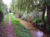
The River Ingol is a small river in the west of the English
county of Norfolk
.
, about 30m above sea level. It flows in a westerly direction across agricultural land towards Snettisham
, and north of the hamlet of Ingoldisthorpe
.
.jpg)
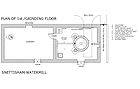
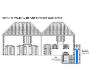 On the river at Snettisham there stands a watermill
TF68083346 52.8724°N 0.4959°W. This was built in 1800 for £800 at a time when bread
was scarce and it was built by the community of Snettisham
for the people of the village. It is believed that the present mill was built on an existing site although virtually no records have so far been found apart from the fact that Thomas Stonne was a Snettisham miller in 1626. At the time of Domesday there were seven mills in Snettisham more than in any other Norfolk village. Today's mill is very small and originally consisted of a single small structure built of local dark brown carrstone with a pantiled roof. In 1877 machinery was improved and a granary and wagon store were added to the complex. The mill had three pairs of stones and unusually the larger two pairs were driven from above and the smaller pair from below, the latter pair required less power and was used when water levels were low. The mill worked on until 1940 producing flour
and after that was used for animal feed production until 1960. The mill was restored, and brought back to working order by 1984. It was sold in 2008, and a planning application lodged to part convert it to holiday accommodation. Permission was refused. 1 Sept 2008.
England
England is a country that is part of the United Kingdom. It shares land borders with Scotland to the north and Wales to the west; the Irish Sea is to the north west, the Celtic Sea to the south west, with the North Sea to the east and the English Channel to the south separating it from continental...
county of Norfolk
Norfolk
Norfolk is a low-lying county in the East of England. It has borders with Lincolnshire to the west, Cambridgeshire to the west and southwest and Suffolk to the south. Its northern and eastern boundaries are the North Sea coast and to the north-west the county is bordered by The Wash. The county...
.
The Source
The source of the river can be found a little to the west of the village of ShernborneShernborne
Shernborne is a civil parish in the English county of Norfolk.It covers an area of and had a population of 59 in 24 households as of the 2001 census.For the purposes of local government, it falls within the district of King's Lynn and West Norfolk....
, about 30m above sea level. It flows in a westerly direction across agricultural land towards Snettisham
Snettisham
Snettisham is a village and civil parish in the English county of Norfolk. It is located near the west coast of Norfolk, some south of the seaside resort of Hunstanton, north of the town of King's Lynn and north-west of the city of Norwich....
, and north of the hamlet of Ingoldisthorpe
Ingoldisthorpe
Ingoldisthorpe is a village and civil parish in the north-west of the English county of Norfolk. It is located approximately north-east of the town King's Lynn and from the county town of Norwich....
.
Watermill at Snettisham
Watermill
A watermill is a structure that uses a water wheel or turbine to drive a mechanical process such as flour, lumber or textile production, or metal shaping .- History :...
TF68083346 52.8724°N 0.4959°W. This was built in 1800 for £800 at a time when bread
Bread
Bread is a staple food prepared by cooking a dough of flour and water and often additional ingredients. Doughs are usually baked, but in some cuisines breads are steamed , fried , or baked on an unoiled frying pan . It may be leavened or unleavened...
was scarce and it was built by the community of Snettisham
Snettisham
Snettisham is a village and civil parish in the English county of Norfolk. It is located near the west coast of Norfolk, some south of the seaside resort of Hunstanton, north of the town of King's Lynn and north-west of the city of Norwich....
for the people of the village. It is believed that the present mill was built on an existing site although virtually no records have so far been found apart from the fact that Thomas Stonne was a Snettisham miller in 1626. At the time of Domesday there were seven mills in Snettisham more than in any other Norfolk village. Today's mill is very small and originally consisted of a single small structure built of local dark brown carrstone with a pantiled roof. In 1877 machinery was improved and a granary and wagon store were added to the complex. The mill had three pairs of stones and unusually the larger two pairs were driven from above and the smaller pair from below, the latter pair required less power and was used when water levels were low. The mill worked on until 1940 producing flour
Flour
Flour is a powder which is made by grinding cereal grains, other seeds or roots . It is the main ingredient of bread, which is a staple food for many cultures, making the availability of adequate supplies of flour a major economic and political issue at various times throughout history...
and after that was used for animal feed production until 1960. The mill was restored, and brought back to working order by 1984. It was sold in 2008, and a planning application lodged to part convert it to holiday accommodation. Permission was refused. 1 Sept 2008.