
Antingham
Encyclopedia
Antingham is a village and civil parish in the north of the English county of Norfolk
. The village is located about 6 miles (9.7 km) south of Cromer
and 3 miles (4.8 km) north of North Walsham
. The nearest railway station is at Gunton
for the Bittern Line
which runs between Sheringham
, Cromer
and Norwich.The Nearest Airport is at Norwich
which is 17.5 miles (28.2 km) south of the village.
The civil parish has an area of 6.12 square kilometres and in the 2001 census
had a population of 287 in 120 households. For the purposes of local government, the parish falls within the district
of North Norfolk
.
and Southrepps
. The eastern boundary, which follows the River Ant, is with Swafield
, and south are the parishes of North Walsham
and Felmingham
. To west lies the parishes of Hanworth
and Suffield
with most of this boundary following the edge of Gunton Park. The parish is dissected north to south by the A149 road
from King’s Lynn to Great Yarmouth
. The parish also straddles the railway line
which runs between Sheringham
, Cromer
and Norwich.
In the south east corner of the parish are Antingham Ponds which provide the source of the River Ant
, a tributary of the River Bure
.
of 1085 where its, its population, land ownership and productive resources were extensively detailed.In the survey Antingham is recorded by the name of Antigeham, Antingham and Attinga.
The main tenants being Roger Bigot
and Thurston Fitzguy from him. The survey also list that there have always been 4 villagers; 4 smallholders on this land. Then and Later 1½ ploughs, now 2½ ploughs; Meadow, 3 acres. Always 2 men’s ploughs. Valued then and later 25s; now 36s.
add t
Norfolk
Norfolk is a low-lying county in the East of England. It has borders with Lincolnshire to the west, Cambridgeshire to the west and southwest and Suffolk to the south. Its northern and eastern boundaries are the North Sea coast and to the north-west the county is bordered by The Wash. The county...
. The village is located about 6 miles (9.7 km) south of Cromer
Cromer
Cromer is a coastal town and civil parish in north Norfolk, England. The local government authority is North Norfolk District Council, whose headquarters is in Holt Road in the town. The town is situated 23 miles north of the county town, Norwich, and is 4 miles east of Sheringham...
and 3 miles (4.8 km) north of North Walsham
North Walsham
North Walsham is a market town and civil parish in Norfolk, England in the North Norfolk district.-Demographics:The civil parish has an area of and in the 2001 census had a population of 11,998. For the purposes of local government, the parish falls within the district of North...
. The nearest railway station is at Gunton
Gunton railway station
Gunton is a railway station on the Bittern Line which connects the city of Norwich to the North Norfolk coastal towns of Cromer and Sheringham in East Anglia, England. There is no village of this name, the station being actually situated in the parish of Thorpe Market...
for the Bittern Line
Bittern Line
The Bittern Line is a railway line from Norwich to Cromer then Sheringham in Norfolk, England. It is one of the most scenic in the East of England traversing the Norfolk Broads on its route to the Area of Outstanding Natural Beauty on the North Norfolk Coast. The line is part of the Network Rail...
which runs between Sheringham
Sheringham
Sheringham is a seaside town in Norfolk, England, west of Cromer.The motto of the town, granted in 1953 to the Sheringham Urban District Council, is Mare Ditat Pinusque Decorat, Latin for "The sea enriches and the pine adorns"....
, Cromer
Cromer
Cromer is a coastal town and civil parish in north Norfolk, England. The local government authority is North Norfolk District Council, whose headquarters is in Holt Road in the town. The town is situated 23 miles north of the county town, Norwich, and is 4 miles east of Sheringham...
and Norwich.The Nearest Airport is at Norwich
Norwich Airport
Norwich Airport may refer to:* Norwich International Airport in Norwich, Norfolk, England* Norwich Lt. Warren Eaton Airport in Norwich, New York, United States* Norwich Airport in Norwich, Kansas, United States...
which is 17.5 miles (28.2 km) south of the village.
The civil parish has an area of 6.12 square kilometres and in the 2001 census
United Kingdom Census 2001
A nationwide census, known as Census 2001, was conducted in the United Kingdom on Sunday, 29 April 2001. This was the 20th UK Census and recorded a resident population of 58,789,194....
had a population of 287 in 120 households. For the purposes of local government, the parish falls within the district
Non-metropolitan district
Non-metropolitan districts, or colloquially shire districts, are a type of local government district in England. As created, they are sub-divisions of non-metropolitan counties in a so-called "two-tier" arrangement...
of North Norfolk
North Norfolk
North Norfolk is a local government district in Norfolk, United Kingdom. Its council is based in Cromer. The council headquarters can be found approximately out of the town of Cromer on the Holt Road.-History:...
.
Location
The parish of Antingham has boundaries with seven other neighbouring parishes. Two the north are the parishes of Thorpe MarketThorpe Market
Thorpe Market is a village in the English county of Norfolk. The village is 4.4 miles south of Cromer, and 20.5 miles north of Norwich. The nearest railway station is at Gunton for the Bittern Line which runs between Sheringham, Cromer and Norwich. The nearest airport is Norwich International...
and Southrepps
Southrepps
Southrepps is a village and a civil parish in the English county of Norfolk. The village is 5.2 miles southeast of Cromer, 21.9 miles north of Norwich and 136 miles north of London. The village lies west of the A149 between Kings Lynn and Great Yarmouth. The nearest railway station is at Gunton for...
. The eastern boundary, which follows the River Ant, is with Swafield
Swafield
Swafield is a village and a civil parish in the English county of Norfolk. The village is north north east of Norwich, south south East of Cromer and north-east of London. The village lies north of the town of North Walsham. The village sits astride the B1145 Kings Lynn to Mundesley road that...
, and south are the parishes of North Walsham
North Walsham
North Walsham is a market town and civil parish in Norfolk, England in the North Norfolk district.-Demographics:The civil parish has an area of and in the 2001 census had a population of 11,998. For the purposes of local government, the parish falls within the district of North...
and Felmingham
Felmingham
Felmingham is a village and civil parish in the English county of Norfolk.It covers an area of and had a population of 564 in 218 households as of the 2001 census.For the purposes of local government, it falls within the district of North Norfolk....
. To west lies the parishes of Hanworth
Hanworth
Hanworth lies to the south east of Feltham in the London Borough of Hounslow. The name is thought to come from the Anglo Saxon words “haen” and “worth”, meaning “small homestead”....
and Suffield
Suffield
Suffield may refer to:* Suffield, Alberta, or Canadian Forces Base Suffield which is located to the north.* Suffield, Connecticut, USA* Suffield Township, Ohio, USA* Suffield, Norfolk, England* Suffield, North Yorkshire, England...
with most of this boundary following the edge of Gunton Park. The parish is dissected north to south by the A149 road
A149 road
The A149 is a major route in Norfolk, linking Kings Lynn to Great Yarmouth. It runs via the coast rather than on a more direct route such as the A47. The eastern section runs through The Broads.-Kings Lynn to Wells next the Sea:...
from King’s Lynn to Great Yarmouth
Great Yarmouth
Great Yarmouth, often known to locals as Yarmouth, is a coastal town in Norfolk, England. It is at the mouth of the River Yare, east of Norwich.It has been a seaside resort since 1760, and is the gateway from the Norfolk Broads to the sea...
. The parish also straddles the railway line
Bittern Line
The Bittern Line is a railway line from Norwich to Cromer then Sheringham in Norfolk, England. It is one of the most scenic in the East of England traversing the Norfolk Broads on its route to the Area of Outstanding Natural Beauty on the North Norfolk Coast. The line is part of the Network Rail...
which runs between Sheringham
Sheringham
Sheringham is a seaside town in Norfolk, England, west of Cromer.The motto of the town, granted in 1953 to the Sheringham Urban District Council, is Mare Ditat Pinusque Decorat, Latin for "The sea enriches and the pine adorns"....
, Cromer
Cromer
Cromer is a coastal town and civil parish in north Norfolk, England. The local government authority is North Norfolk District Council, whose headquarters is in Holt Road in the town. The town is situated 23 miles north of the county town, Norwich, and is 4 miles east of Sheringham...
and Norwich.
In the south east corner of the parish are Antingham Ponds which provide the source of the River Ant
River Ant
The River Ant is a tributary river of the River Bure in the county of Norfolk, England. It is 17 miles long , and has an overall drop of 25 metres from source to mouth...
, a tributary of the River Bure
River Bure
The River Bure is a river in the county of Norfolk, England, most of it in The Broads. The Bure rises near Melton Constable, upstream of Aylsham, which was the original head of navigation. Nowadays, the head of navigation is downstream at Coltishall Bridge...
.
Description
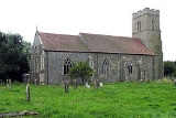
The village of Antingham sit astride the Southrepps road which is on the eastern side of the A149 and runs north to south from that road to the village of Southrepps. The centre of the village is at the crossroads of Elderton Lane, Sandy Lane and Southrepps Road. There is a level crossing on Southrepps Road 200 meters south of this crossroads. The parish church can be found in the south of the village close to the A149 in Church Lane. The Parish church is called Saint Mary's and stands next to the ruins of Saint Margaret’s Church which was abandoned in the late 17th century.Name origin
The name of Antingham originates from an Old English word meaning homestead of the family or followers of a man called Anta.The Domesday Book
Antingham has an entry in the Domesday BookDomesday Book
Domesday Book , now held at The National Archives, Kew, Richmond upon Thames in South West London, is the record of the great survey of much of England and parts of Wales completed in 1086...
of 1085 where its, its population, land ownership and productive resources were extensively detailed.In the survey Antingham is recorded by the name of Antigeham, Antingham and Attinga.
The main tenants being Roger Bigot
Roger Bigod, 1st Earl of Norfolk
Roger Bigod was a Norman knight who came to England in the Norman Conquest. He held great power in East Anglia, and five of his descendants were Earl of Norfolk. He was also known as Roger Bigot, appearing as such as a witness to the Charter of Liberties of Henry I of England.-Biography:Roger came...
and Thurston Fitzguy from him. The survey also list that there have always been 4 villagers; 4 smallholders on this land. Then and Later 1½ ploughs, now 2½ ploughs; Meadow, 3 acres. Always 2 men’s ploughs. Valued then and later 25s; now 36s.
External links
- Information from Genuki Norfolk on Antingham.
- Antingham Bone Mills
add t