
1962 Atlantic hurricane season
Encyclopedia
The 1962 Atlantic hurricane season was the least active since 1939
, with only five named storms
. Although the season officially began on June 15, the first storm did not form until August 26. Hurricane Alma brushed the outer banks before becoming extratropical southeast of New England
, destroying hundreds of boats and producing beneficial rainfall. In late August, Tropical Storm Becky developed unusually far east in the Atlantic Ocean, becoming the easternmost storm on record to recurve to the northeast. Celia followed in the September, forming east of the Lesser Antilles and executing a loop near Bermuda before dissipating. Hurricane Daisy
was the costliest of the season, leaving about $1.1 million in damage in New England (1961 USD
). The storm dropped the highest rainfall total on record in Maine, and its precipitation caused 22 traffic fatalities. The final hurricane – Ella – was also the strongest, remaining offshore of the eastern United States but causing two deaths.
In addition to the five named storms, there were three non-developing tropical depressions. The first struck Texas in August, causing street flooding and killing three. The second of three formed off the west coast of Florida and flooded widespread areas after 1 in 100 year
rainfall. The floods affected 5,000 houses and caused millions in damage. The third of three non-developing storms moved across the Caribbean before striking Nicaragua in October. The season ended on November 15.
began operations with no new equipment, and the warning agency instead opted to improve with the existing equipment. The agency had access to a system of radars that extended from Brownsville, Texas
to Eastport, Maine
, which was set up in 1961. Although satellite imagery technology was available, the system was not fully active to provide daily images of Atlantic hurricanes. The season officially ended on November 15.
During the season, three hurricanes developed from five named storms
. This was below the average of 10 storms per season, and represented the fewest tropical storms since 1939. Four of the five storms developed from the intertropical convergence zone
. The decreased activity is partially due to the westerlies
extending further south than usual, as well as a persistent ridge
. In addition, temperatures in the eastern United States were cooler than usual. Activity through September 10 was the quietest in 30 years.
The only region of the United States threatened by hurricanes was New England, although no stations recorded hurricane force winds in the country. This was the first such occurrence during the 20th century that no tropical storms or hurricanes hit the country. Overall damage was the lowest in several years.
, it became better organized, and on August 26 developed into a tropical depression along the southeast Florida coast. It moved northward along the coast, located beneath an anticyclone
that aided in its intensification. The depression began a motion to the northeast on August 27, and that day it strengthened into Tropical Storm Alma about 150 mi (241.4 km) east of the Florida/Georgia border. This marked the latest development of the first storm since 1941
. Alma steadily intensified as it paralleled the coastline of the Carolinas, becoming a hurricane on August 28 a few miles off the coast of Cape Hatteras
. Despite its proximity, the storm produced peak wind gusts of only 53 mph (85.3 km/h) in Nags Head
. Wind gusts downed a power pole in Hatteras
, which caused an hour long power outage for one-third of the town. There, the storm tide was 3 ft (0.9144 m) above normal, which resulted in some erosion. The highest rainfall total from Alma in the United States was a report of 10.38 inches (263.7 mm) in Cape Hatteras. Damage in the state amounted to $35,000.
After passing the Outer Banks, Alma continued to intensify further, reaching peak winds of 100 mph (160.9 km/h) about 85 mi (135 km) south of Nantucket. Despite its intensity, the hurricane never developed a well-defined eye
. Alma quickly weakened to a tropical storm as its made its closest approach to New England, due to cooler water temperatures. In Rhode Island and Massachusetts along the coast, the storm produced northerly winds of 60 mph (96.6 km/h), and one house was damaged by a fallen tree. Tides reached 2 ft (0.6096 m) above normal, which resulted in minor coastal flooding. However, Alma produced strong waves that destroyed over 100 boats. Damage from the storm was estimated at less than $1 million, though its rains were beneficial to drought-stricken areas of New England. Precipitation extended northward through Maine, and storm damage was reported as far north as Portsmouth, New Hampshire
. Slick roads resulted in several traffic accidents, although there were no deaths. After moving by the region, Alma turned to the southeast due to a high pressure system to its north. It became extratropical on August 30, and subsequently executed a clockwise loop before being absorbed by a trough to the south of Newfoundland on September 2.
throughout its duration, which displaced the convection from the center to its northeast. The depression struck just west of the Texas/Louisiana border on August 29 before dissipating on August 30. Rainfall in Texas was minimal, estimated around 1 in (25.4 mm). However, heavy amounts of precipitation fell across Louisiana, peaking at 23.13 in (587.5 mm) near Hackberry
. Rainfall extended northeastward through Arkansas and Missouri. On August 29 as the depression moved ashore, heavy rainfall caused street flooding in Cameron, Louisiana
. Two tornadoes were reported in the town, one of which produced winds of 80 mph (130 km/h). The storms damaged 115 houses or trailers, of which one was destroyed. There were 30 people injured, of whom 18 required hospital attention, and there were three deaths.
islands with rainfall, during which it moved slowly to the west and west-northwest. Late on August 28, it was estimated that the depression intensified into a tropical storm. The next day, satellite imagery observed a well-developed tropical cyclone in the far eastern Atlantic Ocean. In addition, a ship reported winds of force 9 on the Beaufort scale
, suggesting winds of 50 mph (85 km/h). On that basis, the Weather Bureau
initiated advisories on Tropical Storm Becky, despite the agency only issuing advisories for storms west of 35º W
. Around that time, the storm moved over an area of anomalously warm water temperatures
, which allowed for its intensification. On August 30, Becky turned to the north and northeast due to an approaching trough
, becoming the easternmost cyclone since 1886 that a storm began a motion to the north. A Hurricane Hunters
flight on August 31 indicated that Becky became extratropical about 70 mi (110 km) south of Santa Maria Island
in the Azores
. The storm's remnants continued to the northeast, dissipating on August 31 about 320 mi (520 km) west of Spain.
developed into a tropical depression on September 12, about 1000 mi (1600 km) east of the Lesser Antilles
. However, satellite imagery indicated that it could have become a tropical cyclone a day earlier. Late on September 12, a ship reported winds of 40 mph (64.4 km/h), which provided the basis for the San Juan
Weather Bureau to initiate advisories on Tropical Storm Celia. The storm quickly attained peak winds of 70 mph (110 km/h), and on September 13 a hurricane watch
was issued for the northern Leeward Islands
. However, Celia passed beneath a mid- to upper-level trough and quickly weakened. By late on September 14, a hurricane hunters flight indicated that the storm's structure no longer resembled that of a tropical cyclone. The next day, Celia weakened to a tropical depression, and the Weather Bureau discontinued tropical cyclone advisories. It turned to the north and later to the east, passing well southeast of Bermuda. On September 18, Celia began executing a loop to the north, during which it re-intensified into a tropical storm, as reported by ships. It attained winds of 45 mph (75 km/h) on September 19, but again weakened to a tropical depression the next day. Celia became extratropical on September 21, without having affected land.
to Tampa, Florida
. The highest total was 14.61 in (371.1 mm) in Sarasota
, although precipitation of over 1 in (25.4 mm) extended into Georgia and extreme southern South Carolina. A developing cyclone off the Carolinas caused the dissipation of the depression on September 23.
The rains in Sarasota were the highest since 1945, and some locations experienced 1 in 100 year
rainfall totals. The rains resulted in 3 ft (0.9144 m) of floodwaters across western Florida, and both the Manatee River
and the Phillippi Creek experienced record crests. The flooding entered over 5,000 houses, which forced the evacuation of more than 100 families. The floods also caused schools to close in three counties. In addition, floodwaters affected thousands of acres of farmlands in six counties, and some did not dry out for several weeks. Wind gusts reached 58 mph (93.3 km/h) in eastern Florida, and more than 20,000 people were left without power. There was one death in the state related to the storm, and damage was estimated at $2.78 million.
aloft, the storm continued to gradually intensify, reaching hurricane strength on October 3. Two days later, Daisy turned to the north-northeast and attained peak winds of 110 mph (175 km/h). While passing west of Bermuda, the hurricane weakened slightly, although it re-intensified to its peak strength late on October 6. Cool air imparted weakening as Daisy turned northwestward, and on October 8, the hurricane slowed as it turned eastward, striking Yarmouth, Nova Scotia
with winds of 75 mph (120 km/h). It became extratropical later that day, and Daisy dissipated on October 9 south of Newfoundland.
In New England, Hurricane Daisy's outer rainbands combined with an approaching nor'easter
to drop torrential rainfall over the region for 65 hours, producing upwards of 12 in (304.8 mm) in portions of Massachusetts. The highest total from Daisy alone was 9.47 in (240.5 mm) at Portland International Jetport
in Maine; this was the state's highest tropical cyclone rainfall total in the period from 1950 to 2011. Across the region, the rains caused widespread flood damage. In Maine, wind gusts reaching 70 mph (112.7 km/h) destroyed hundreds of small boats, along with high waves from the storm. In New England, Daisy left five injuries, one direct death, and about $1.1 million in damage. Slick roads, however, resulted in 22 traffic fatalities. In Nova Scotia, winds gusted to 85 mph (137 km/h), which destroyed three boats and left two towns without power service. Rough seas killed six people in the province.
Ella is historically notable for its role in the Cuban Missile Crisis
. The storm greatly complicated naval operations relating to the 'quarantine' blockade of Cuba and badly damaged several Soviet nuclear-armed submarines en route to the island, contributing to the escalation of the B-59 Incident. Early in its duration, Hurricane Ella briefly threatened to strike the North Carolina coastline. Although it remained offshore, the hurricane produced significant beach erosion along the coast. There were two associated deaths from a missing motor boat that left Charleston, South Carolina
. The crew of two was declared deceased after a Coast Guard, Navy, and Air Force search failed to locate their bodies. There was no damage in Canada from its remnants.
1939 Atlantic hurricane season
The 1939 Atlantic hurricane season officially began on June 16, 1939, and lasted until October 31, 1939. These dates mark the period of each year when most tropical cyclones form in the Atlantic basin...
, with only five named storms
Tropical cyclone naming
Tropical cyclones have officially been named since 1945 and are named for a variety of reasons, which include to facilitate communications between forecasters and the public when forecasts, watches, and warnings are issued. Names also reduce confusion about what storm is being described, as more...
. Although the season officially began on June 15, the first storm did not form until August 26. Hurricane Alma brushed the outer banks before becoming extratropical southeast of New England
New England
New England is a region in the northeastern corner of the United States consisting of the six states of Maine, New Hampshire, Vermont, Massachusetts, Rhode Island, and Connecticut...
, destroying hundreds of boats and producing beneficial rainfall. In late August, Tropical Storm Becky developed unusually far east in the Atlantic Ocean, becoming the easternmost storm on record to recurve to the northeast. Celia followed in the September, forming east of the Lesser Antilles and executing a loop near Bermuda before dissipating. Hurricane Daisy
Hurricane Daisy (1962)
Hurricane Daisy was a moderate hurricane in the 1962 Atlantic hurricane season, that caused severe damage in New England, and the Canadian Maritimes. The fourth named storm of the 1962 Atlantic hurricane season, it became a tropical depression on September 29, while moving west-northwest. On...
was the costliest of the season, leaving about $1.1 million in damage in New England (1961 USD
United States dollar
The United States dollar , also referred to as the American dollar, is the official currency of the United States of America. It is divided into 100 smaller units called cents or pennies....
). The storm dropped the highest rainfall total on record in Maine, and its precipitation caused 22 traffic fatalities. The final hurricane – Ella – was also the strongest, remaining offshore of the eastern United States but causing two deaths.
In addition to the five named storms, there were three non-developing tropical depressions. The first struck Texas in August, causing street flooding and killing three. The second of three formed off the west coast of Florida and flooded widespread areas after 1 in 100 year
Return period
A return period also known as a recurrence interval is an estimate of the interval of time between events like an earthquake, flood or river discharge flow of a certain intensity or size. It is a statistical measurement denoting the average recurrence interval over an extended period of time, and...
rainfall. The floods affected 5,000 houses and caused millions in damage. The third of three non-developing storms moved across the Caribbean before striking Nicaragua in October. The season ended on November 15.
Season activity
The hurricane season officially began on June 15, 1962. The National Hurricane CenterNational Hurricane Center
The National Hurricane Center , located at Florida International University in Miami, Florida, is the division of the National Weather Service responsible for tracking and predicting weather systems within the tropics between the Prime Meridian and the 140th meridian west poleward to the 30th...
began operations with no new equipment, and the warning agency instead opted to improve with the existing equipment. The agency had access to a system of radars that extended from Brownsville, Texas
Brownsville, Texas
Brownsville is a city in the southernmost tip of the state of Texas, in the United States. It is located on the northern bank of the Rio Grande, directly north and across the border from Matamoros, Tamaulipas, Mexico. Brownsville is the 16th largest city in the state of Texas with a population of...
to Eastport, Maine
Eastport, Maine
Eastport is a small city in Washington County, Maine, United States. The population was 1,640 at the 2000 census. The principal island is Moose Island, which is connected to the mainland by causeway...
, which was set up in 1961. Although satellite imagery technology was available, the system was not fully active to provide daily images of Atlantic hurricanes. The season officially ended on November 15.
During the season, three hurricanes developed from five named storms
Tropical cyclone naming
Tropical cyclones have officially been named since 1945 and are named for a variety of reasons, which include to facilitate communications between forecasters and the public when forecasts, watches, and warnings are issued. Names also reduce confusion about what storm is being described, as more...
. This was below the average of 10 storms per season, and represented the fewest tropical storms since 1939. Four of the five storms developed from the intertropical convergence zone
Intertropical Convergence Zone
The Intertropical Convergence Zone , known by sailors as The Doldrums, is the area encircling the earth near the equator where winds originating in the northern and southern hemispheres come together....
. The decreased activity is partially due to the westerlies
Westerlies
The Westerlies, anti-trades, or Prevailing Westerlies, are the prevailing winds in the middle latitudes between 30 and 60 degrees latitude, blowing from the high pressure area in the horse latitudes towards the poles. These prevailing winds blow from the west to the east, and steer extratropical...
extending further south than usual, as well as a persistent ridge
Ridge (meteorology)
A ridge is an elongated region of relatively high atmospheric pressure, the opposite of a trough....
. In addition, temperatures in the eastern United States were cooler than usual. Activity through September 10 was the quietest in 30 years.
The only region of the United States threatened by hurricanes was New England, although no stations recorded hurricane force winds in the country. This was the first such occurrence during the 20th century that no tropical storms or hurricanes hit the country. Overall damage was the lowest in several years.
Hurricane Alma
The origins of Alma was from a weak circulation observed in the eastern Atlantic on August 14. The system tracked westward and was observed by a research flight on August 18. Four days later, the system entered the Caribbean Sea, later crossing the Greater Antilles while remaining weak and disorganized. After entering the Straits of FloridaStraits of Florida
The Straits of Florida, Florida Straits, or Florida Strait is a strait located south-southeast of the North American mainland, generally accepted to be between the Gulf of Mexico and the Atlantic Ocean, and between the Florida Keys and Cuba. The strait carries the Florida Current, the beginning of...
, it became better organized, and on August 26 developed into a tropical depression along the southeast Florida coast. It moved northward along the coast, located beneath an anticyclone
Anticyclone
An anticyclone is a weather phenomenon defined by the United States' National Weather Service's glossary as "[a] large-scale circulation of winds around a central region of high atmospheric pressure, clockwise in the Northern Hemisphere, counterclockwise in the Southern Hemisphere"...
that aided in its intensification. The depression began a motion to the northeast on August 27, and that day it strengthened into Tropical Storm Alma about 150 mi (241.4 km) east of the Florida/Georgia border. This marked the latest development of the first storm since 1941
1941 Atlantic hurricane season
The 1941 Atlantic hurricane season was the period during 1941 in which tropical cyclones formed in the Atlantic Basin. It was a relatively inactive hurricane season, with only six known storms. It officially began on June 16, 1941 and lasted until November 1, 1941. These dates delimit the period of...
. Alma steadily intensified as it paralleled the coastline of the Carolinas, becoming a hurricane on August 28 a few miles off the coast of Cape Hatteras
Cape Hatteras
Cape Hatteras is a cape on the coast of North Carolina. It is the point that protrudes the farthest to the southeast along the northeast-to-southwest line of the Atlantic coast of North America...
. Despite its proximity, the storm produced peak wind gusts of only 53 mph (85.3 km/h) in Nags Head
Nags Head, North Carolina
Nags Head is a town in Dare County, North Carolina, United States. The population was 2,700 at the 2000 census.-History:Early maps of the area show Nags Head as a promontory of land characterized by high sand dunes visible from miles at sea...
. Wind gusts downed a power pole in Hatteras
Hatteras, North Carolina
Hatteras is an unincorporated community in Dare County, North Carolina, United States, on the Outer Banks island of Hatteras. North Carolina Highway 12 passes through the community linking it to Frisco and Ocracoke . It is south of the famous Cape Hatteras and the Cape Hatteras Lighthouse in Buxton...
, which caused an hour long power outage for one-third of the town. There, the storm tide was 3 ft (0.9144 m) above normal, which resulted in some erosion. The highest rainfall total from Alma in the United States was a report of 10.38 inches (263.7 mm) in Cape Hatteras. Damage in the state amounted to $35,000.
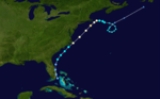
After passing the Outer Banks, Alma continued to intensify further, reaching peak winds of 100 mph (160.9 km/h) about 85 mi (135 km) south of Nantucket. Despite its intensity, the hurricane never developed a well-defined eye
Eye (cyclone)
The eye is a region of mostly calm weather found at the center of strong tropical cyclones. The eye of a storm is a roughly circular area and typically 30–65 km in diameter. It is surrounded by the eyewall, a ring of towering thunderstorms where the second most severe weather of a cyclone...
. Alma quickly weakened to a tropical storm as its made its closest approach to New England, due to cooler water temperatures. In Rhode Island and Massachusetts along the coast, the storm produced northerly winds of 60 mph (96.6 km/h), and one house was damaged by a fallen tree. Tides reached 2 ft (0.6096 m) above normal, which resulted in minor coastal flooding. However, Alma produced strong waves that destroyed over 100 boats. Damage from the storm was estimated at less than $1 million, though its rains were beneficial to drought-stricken areas of New England. Precipitation extended northward through Maine, and storm damage was reported as far north as Portsmouth, New Hampshire
Portsmouth, New Hampshire
Portsmouth is a city in Rockingham County, New Hampshire in the United States. It is the largest city but only the fourth-largest community in the county, with a population of 21,233 at the 2010 census...
. Slick roads resulted in several traffic accidents, although there were no deaths. After moving by the region, Alma turned to the southeast due to a high pressure system to its north. It became extratropical on August 30, and subsequently executed a clockwise loop before being absorbed by a trough to the south of Newfoundland on September 2.
August tropical depression
On August 27, a tropical depression formed in the western Gulf of Mexico about 280 mi (450 km) northeast of Tampico, Tamaulipas. It moved slowly to the north-northwest around a ridge without intensifying beyond winds of 30 mph (45 km/h). The system encountered wind shearWind shear
Wind shear, sometimes referred to as windshear or wind gradient, is a difference in wind speed and direction over a relatively short distance in the atmosphere...
throughout its duration, which displaced the convection from the center to its northeast. The depression struck just west of the Texas/Louisiana border on August 29 before dissipating on August 30. Rainfall in Texas was minimal, estimated around 1 in (25.4 mm). However, heavy amounts of precipitation fell across Louisiana, peaking at 23.13 in (587.5 mm) near Hackberry
Hackberry, Louisiana
Hackberry is a census-designated place in Cameron Parish, Louisiana, United States. The population was 1,699 at the 2000 census. It is part of the Lake Charles Metropolitan Statistical Area.-Geography:Hackberry is located at ....
. Rainfall extended northeastward through Arkansas and Missouri. On August 29 as the depression moved ashore, heavy rainfall caused street flooding in Cameron, Louisiana
Cameron, Louisiana
Cameron is a census-designated place in and the parish seat of Cameron Parish, Louisiana, United States. The population was 1,965 at the 2000 census. It is part of the Lake Charles Metropolitan Statistical Area...
. Two tornadoes were reported in the town, one of which produced winds of 80 mph (130 km/h). The storms damaged 115 houses or trailers, of which one was destroyed. There were 30 people injured, of whom 18 required hospital attention, and there were three deaths.
Tropical Storm Becky
A tropical disturbance emerged from Africa in late August and developed into a weak tropical depression on August 27. For about 30 hours, the system affected the Cape VerdeCape Verde
The Republic of Cape Verde is an island country, spanning an archipelago of 10 islands located in the central Atlantic Ocean, 570 kilometres off the coast of Western Africa...
islands with rainfall, during which it moved slowly to the west and west-northwest. Late on August 28, it was estimated that the depression intensified into a tropical storm. The next day, satellite imagery observed a well-developed tropical cyclone in the far eastern Atlantic Ocean. In addition, a ship reported winds of force 9 on the Beaufort scale
Beaufort scale
The Beaufort Scale is an empirical measure that relates wind speed to observed conditions at sea or on land. Its full name is the Beaufort Wind Force Scale.-History:...
, suggesting winds of 50 mph (85 km/h). On that basis, the Weather Bureau
National Oceanic and Atmospheric Administration
The National Oceanic and Atmospheric Administration , pronounced , like "noah", is a scientific agency within the United States Department of Commerce focused on the conditions of the oceans and the atmosphere...
initiated advisories on Tropical Storm Becky, despite the agency only issuing advisories for storms west of 35º W
Longitude
Longitude is a geographic coordinate that specifies the east-west position of a point on the Earth's surface. It is an angular measurement, usually expressed in degrees, minutes and seconds, and denoted by the Greek letter lambda ....
. Around that time, the storm moved over an area of anomalously warm water temperatures
Sea surface temperature
Sea surface temperature is the water temperature close to the oceans surface. The exact meaning of surface varies according to the measurement method used, but it is between and below the sea surface. Air masses in the Earth's atmosphere are highly modified by sea surface temperatures within a...
, which allowed for its intensification. On August 30, Becky turned to the north and northeast due to an approaching trough
Trough (meteorology)
A trough is an elongated region of relatively low atmospheric pressure, often associated with fronts.Unlike fronts, there is not a universal symbol for a trough on a weather chart. The weather charts in some countries or regions mark troughs by a line. In the United States, a trough may be marked...
, becoming the easternmost cyclone since 1886 that a storm began a motion to the north. A Hurricane Hunters
Hurricane Hunters
The Hurricane Hunters are aircraft that fly into tropical cyclones in the North Atlantic Ocean and Northeastern Pacific Ocean for the specific purpose of directly measuring weather data in and around those storms. In the United States, the Air Force, Navy, and NOAA units have all participated in...
flight on August 31 indicated that Becky became extratropical about 70 mi (110 km) south of Santa Maria Island
Santa Maria Island
Santa Maria , Portuguese for Saint Mary, is an island located in the eastern group of the Azores archipelago and the southernmost island in the Azores...
in the Azores
Azores
The Archipelago of the Azores is composed of nine volcanic islands situated in the middle of the North Atlantic Ocean, and is located about west from Lisbon and about east from the east coast of North America. The islands, and their economic exclusion zone, form the Autonomous Region of the...
. The storm's remnants continued to the northeast, dissipating on August 31 about 320 mi (520 km) west of Spain.
Tropical Storm Celia
A tropical waveTropical wave
Tropical waves, easterly waves, or tropical easterly waves, also known as African easterly waves in the Atlantic region, are a type of atmospheric trough, an elongated area of relatively low air pressure, oriented north to south, which move from east to west across the tropics causing areas of...
developed into a tropical depression on September 12, about 1000 mi (1600 km) east of the Lesser Antilles
Lesser Antilles
The Lesser Antilles are a long, partly volcanic island arc in the Western Hemisphere. Most of its islands form the eastern boundary of the Caribbean Sea with the Atlantic Ocean, with the remainder located in the southern Caribbean just north of South America...
. However, satellite imagery indicated that it could have become a tropical cyclone a day earlier. Late on September 12, a ship reported winds of 40 mph (64.4 km/h), which provided the basis for the San Juan
San Juan, Puerto Rico
San Juan , officially Municipio de la Ciudad Capital San Juan Bautista , is the capital and most populous municipality in Puerto Rico, an unincorporated territory of the United States. As of the 2010 census, it had a population of 395,326 making it the 46th-largest city under the jurisdiction of...
Weather Bureau to initiate advisories on Tropical Storm Celia. The storm quickly attained peak winds of 70 mph (110 km/h), and on September 13 a hurricane watch
Tropical cyclone warnings and watches
Warnings and watches are two levels of alert issued by national weather forecasting bodies to coastal areas threatened by the imminent approach of a tropical cyclone of tropical storm or hurricane intensity. They are notices to the local population and civil authorities to make appropriate...
was issued for the northern Leeward Islands
Leeward Islands
The Leeward Islands are a group of islands in the West Indies. They are the northern islands of the Lesser Antilles chain. As a group they start east of Puerto Rico and reach southward to Dominica. They are situated where the northeastern Caribbean Sea meets the western Atlantic Ocean...
. However, Celia passed beneath a mid- to upper-level trough and quickly weakened. By late on September 14, a hurricane hunters flight indicated that the storm's structure no longer resembled that of a tropical cyclone. The next day, Celia weakened to a tropical depression, and the Weather Bureau discontinued tropical cyclone advisories. It turned to the north and later to the east, passing well southeast of Bermuda. On September 18, Celia began executing a loop to the north, during which it re-intensified into a tropical storm, as reported by ships. It attained winds of 45 mph (75 km/h) on September 19, but again weakened to a tropical depression the next day. Celia became extratropical on September 21, without having affected land.
September Gulf of Mexico tropical depression
An upper-level low spawned a tropical depression off the west coast of Florida on September 20. The depression moved very slowly to the north-northwest, which produced heavy rainfall from NaplesNaples, Florida
Naples is a city in Collier County, Florida, United States. As of July 1, 2007, the U.S. Census Bureau estimated the city's population at 21,653. Naples is a principal city of the Naples–Marco Island Metropolitan Statistical Area, which had an estimated total population of 315,839 on July 1, 2007...
to Tampa, Florida
Tampa, Florida
Tampa is a city in the U.S. state of Florida. It serves as the county seat for Hillsborough County. Tampa is located on the west coast of Florida. The population of Tampa in 2010 was 335,709....
. The highest total was 14.61 in (371.1 mm) in Sarasota
Sarasota, Florida
Sarasota is a city located in Sarasota County on the southwestern coast of the U.S. state of Florida. It is south of the Tampa Bay Area and north of Fort Myers...
, although precipitation of over 1 in (25.4 mm) extended into Georgia and extreme southern South Carolina. A developing cyclone off the Carolinas caused the dissipation of the depression on September 23.
The rains in Sarasota were the highest since 1945, and some locations experienced 1 in 100 year
Return period
A return period also known as a recurrence interval is an estimate of the interval of time between events like an earthquake, flood or river discharge flow of a certain intensity or size. It is a statistical measurement denoting the average recurrence interval over an extended period of time, and...
rainfall totals. The rains resulted in 3 ft (0.9144 m) of floodwaters across western Florida, and both the Manatee River
Manatee River
The Manatee River is a river in Manatee County, Florida. The river arises in the northeastern corner of Manatee County and flows into the Gulf of Mexico at the southern edge of Tampa Bay. The Manatee River has a watershed that is approximately . Lake Manatee, an artificial reservoir, is located...
and the Phillippi Creek experienced record crests. The flooding entered over 5,000 houses, which forced the evacuation of more than 100 families. The floods also caused schools to close in three counties. In addition, floodwaters affected thousands of acres of farmlands in six counties, and some did not dry out for several weeks. Wind gusts reached 58 mph (93.3 km/h) in eastern Florida, and more than 20,000 people were left without power. There was one death in the state related to the storm, and damage was estimated at $2.78 million.
September Caribbean tropical depression
On September 27, a tropical depression developed east of the Lesser Antilles. It moved through the islands without intensifying beyond winds of 30 mph (40 km/h). The depression later crossed the entirety of the Caribbean Sea. On October 3, it struck northeastern Nicaragua, before dissipating the following day over Guatemala.Hurricane Daisy
On September 29, reconnaissance aircraft indicated the formation of a tropical depression to the east of the Lesser Antilles. For several days it moved to the west-northwest, passing just north of the islands without intensifying further. This was due to its presence beneath an upper-level trough, although the system began intensifying as the trough dissipated. On October 2, after turning to the northwest between two high pressure areas, the depression strengthened into Tropical Storm Daisy. Developing an anticycloneAnticyclone
An anticyclone is a weather phenomenon defined by the United States' National Weather Service's glossary as "[a] large-scale circulation of winds around a central region of high atmospheric pressure, clockwise in the Northern Hemisphere, counterclockwise in the Southern Hemisphere"...
aloft, the storm continued to gradually intensify, reaching hurricane strength on October 3. Two days later, Daisy turned to the north-northeast and attained peak winds of 110 mph (175 km/h). While passing west of Bermuda, the hurricane weakened slightly, although it re-intensified to its peak strength late on October 6. Cool air imparted weakening as Daisy turned northwestward, and on October 8, the hurricane slowed as it turned eastward, striking Yarmouth, Nova Scotia
Yarmouth, Nova Scotia
Yarmouth is a town and fishing port located on the Gulf of Maine in rural southwestern Nova Scotia, Canada. It is the shire town of Yarmouth County. The town is located in the heart of the world's largest lobster fishing grounds and has Canada's highest lobster catch.- History :The townsite may...
with winds of 75 mph (120 km/h). It became extratropical later that day, and Daisy dissipated on October 9 south of Newfoundland.
In New England, Hurricane Daisy's outer rainbands combined with an approaching nor'easter
Nor'easter
A nor'easter is a type of macro-scale storm along the East Coast of the United States and Atlantic Canada, so named because the storm travels to the northeast from the south and the winds come from the northeast, especially in the coastal areas of the Northeastern United States and Atlantic Canada...
to drop torrential rainfall over the region for 65 hours, producing upwards of 12 in (304.8 mm) in portions of Massachusetts. The highest total from Daisy alone was 9.47 in (240.5 mm) at Portland International Jetport
Portland International Jetport
Portland International Jetport is a public airport located two miles west of the central business district of Portland, in Cumberland County, Maine, United States. It is owned by the city of Portland...
in Maine; this was the state's highest tropical cyclone rainfall total in the period from 1950 to 2011. Across the region, the rains caused widespread flood damage. In Maine, wind gusts reaching 70 mph (112.7 km/h) destroyed hundreds of small boats, along with high waves from the storm. In New England, Daisy left five injuries, one direct death, and about $1.1 million in damage. Slick roads, however, resulted in 22 traffic fatalities. In Nova Scotia, winds gusted to 85 mph (137 km/h), which destroyed three boats and left two towns without power service. Rough seas killed six people in the province.
Hurricane Ella
In the middle of October, an area of disturbed weather persisted across the Turks and Caicos Islands, associated with an upper-level low. On October 14, a tropical depression developed and moved northward. A day after forming, it intensified into Tropical Storm Ella as it began a track to the northwest, located east of a weakening upper-level trough. On October 17, Ella strengthened further into a hurricane as an anticyclone was gradually developing. An approaching trough turned the hurricane to the east-northeast on October 19, and later that day Ella attained its peak intensity of 115 mph (185 km/h); that made it the strongest hurricane of the season. It gradually weakened over cooler waters while accelerating to the northeast, and its eye grew to an unusually large diameter of 100 mi (160 km/h). Ella became extratropical on October 22 over the northern Atlantic as it interacted with an approaching cold front. Shortly thereafter its remnants moved over Newfoundland before dissipating on October 23.Ella is historically notable for its role in the Cuban Missile Crisis
Cuban Missile Crisis
The Cuban Missile Crisis was a confrontation among the Soviet Union, Cuba and the United States in October 1962, during the Cold War...
. The storm greatly complicated naval operations relating to the 'quarantine' blockade of Cuba and badly damaged several Soviet nuclear-armed submarines en route to the island, contributing to the escalation of the B-59 Incident. Early in its duration, Hurricane Ella briefly threatened to strike the North Carolina coastline. Although it remained offshore, the hurricane produced significant beach erosion along the coast. There were two associated deaths from a missing motor boat that left Charleston, South Carolina
Charleston, South Carolina
Charleston is the second largest city in the U.S. state of South Carolina. It was made the county seat of Charleston County in 1901 when Charleston County was founded. The city's original name was Charles Towne in 1670, and it moved to its present location from a location on the west bank of the...
. The crew of two was declared deceased after a Coast Guard, Navy, and Air Force search failed to locate their bodies. There was no damage in Canada from its remnants.
See also
- List of Atlantic hurricanes
- List of Atlantic hurricane seasons
Storm names
The following names were used for named storms (tropical storms and hurricanes) that formed in the North Atlantic in 1962. Names that were not assigned are marked in . Because of the seasons relatively low impact, no storms were retired during the 1962 season, and none of the storms below were used for the first time.
|