
1941 Atlantic hurricane season
Encyclopedia
The 1941 Atlantic hurricane season was the period during 1941 in which tropical cyclones formed in the Atlantic Basin
. It was a relatively inactive hurricane season
, with only six known storms. It officially began on June 16, 1941 and lasted until November 1, 1941. These dates delimit the period of each year when most tropical cyclone
s tend to form in the Atlantic basin
. Of the six cyclones, four attained hurricane status, and two became major hurricanes. The season had an abnormally late start; the first system formed on September 11, nearly two months after the official beginning date. The season was also short-lived, as all six storms developed in rapid succession. On September 23, three hurricanes existed simultaneously in the Atlantic basin.
In total, the season resulted in about 63 fatalities and over $10 million in damages. The first and last storms of the season were largely insignificant, although the second, fourth, and fifth storms had considerable effects. One hurricane struck Texas
and Louisiana
in late September, disrupting the Louisiana Maneuvers
. Among the most significant storms to impact the United States
was Hurricane Five
, which made landfall in Florida
at Category 3 intensity, inflicting widespread damage. Another major storm—Hurricane Four—traversed the Caribbean, leaving 47 men dead at sea.
. This was an abnormally late start to an Atlantic hurricane season: only on two other occasions between 1887 and 1941 had no storms developed prior to September 11. The storm moved slowly in a generally westward direction for the next few days, peaking as a moderate tropical storm with winds of 45 mph (75 km/h). It made landfall along the northern Texas
coast between Galveston
and Port Arthur
where it caused only minor damage. Near 0000 UTC on September 16, the storm deteriorated into a depression, and dissipated a few hours later.
on September 16 and began moving west-southwest. Operationally, the cyclone was first observed on September 18, to the south of Louisiana
. After intensifying to a Category 1 hurricane, the storm began drifting southward towards the Yucatan Peninsula
, ultimately executing a clockwise loop. By September 21 it had turned northward before assuming a more northwestward course. It moved across the western Gulf of Mexico and went ashore in Texas
on September 23. It curved towards the northeast, passing just east of Houston
, and accelerated as it continued to move inland. The cyclone transitioned into an extratropical storm on September 24, and was last recorded in southern Quebec
.
Warnings and advisories declared in response to the storm were widely distributed, and approximately 25,000 people in the area evacuated their homes. Officials completed various precautionary measures. Wind gusts along the coast reached up to 100 mph (160.9 km/h), and high storm tides were recorded. The hurricane inflicted severe damage; destruction to property was worth an estimated $2 million, with an additional $5 million in damage to crops, notably rice and cotton. Overall, the cyclone killed four people. The hurricane affected the southern Louisiana region one week before the Louisiana Maneuvers
, a prelude to World War II
. Heavy rainfall triggered flooding and swelled rivers, and army vehicles became stuck in the mud as a result. The inclement weather forced hundreds of military aircraft to move inland for shelter.
, but began to recurve away from land late on September 22. It weakened into a tropical storm shortly afterward. The system dissipated on September 25 to the south of Nova Scotia
. The storm had little or no effect on land, but caused significant delays for North Atlantic shipping. One vessel en route from Curaçao
to New York
encountered the storm on two separate occasions, recording Force 8 winds on the Beaufort scale
both times.
. It is estimated that it developed into a tropical storm shortly thereafter. Tracking westward, it passed just south of St. Lucia and emerged into the Caribbean Sea
. By September 25, the storm had reached hurricane strength. Still intensifying, the storm continued generally westward and reached its peak at Category 3 on the Saffir-Simpson Hurricane Scale
. By September 27, the hurricane was situated near Cape Gracias a Dios, Honduras
, and accelerated as it moved across the northernmost stretch of the country. After briefly entering the Gulf of Honduras
, it moved ashore again in the country, about 70 mi (112.7 km) south of Belize
. Gradually weakening, the storm continued inland and weakened to a tropical storm by September 29. The storm emerged over the Bay of Campeche
as a tropical depression and made a final landfall on Veracruz
.
Approximately 47 lives were lost at sea due to the hurricane. The SS Ethel Sakel displayed a "sinking" message on September 25, about 125 mi (201.2 km) north of Aruba
; she later went down with 20 of her 33 crew members. Two other ships sent out distress signals, one of which capsized, all hands lost. Damage on land was also extensive, and three people drowned at Cape Gracias, which was largely destroyed by the storm. Coastal flooding in the town was severe. In Belize, forests sustained major damage. For example, in the Melinda region, high winds brought down about 10% of the large pines.
on October 3. The storm tracked generally westward through The Bahamas, reaching peak winds of 120 miles per hour (193.1 km/h), which corresponds to a Category 3 hurricane on the modern-day Saffir–Simpson Hurricane Scale. After moving across southern Florida the hurricane emerged into the Gulf of Mexico
and made another landfall
along the Florida Panhandle
. Turning toward the north and northeast, it crossed Georgia
and South Carolina
, and entered the Atlantic Ocean
on October 8. The storm fully dissipated several days later.
Preparations for the storm were extensive; residents boarded up homes and businesses, while evacuations were recommended in some coastal areas. In the Bahamas, where winds reached 104 miles per hour (167.4 km/h), the storm killed three people. The city of Nassau
was struck particularly hard. In Florida, damage was relatively severe, and included the deaths of several people. High winds brought down trees and powerlines, though the storm was characterized by highly unusual rainfall patterns. Storm surge in the Everglades
region flooded local streets. As the storm progressed northward, the city of Tallahassee
suffered widespread power outages and damage to numerous vehicles. Throughout the state, the hurricane inflicted $675,000 (1941 USD) in damages. The cyclone later killed one person in Georgia.
. After pushing inland, the storm stalled and weakened to a tropical depression on October 21 before dissipating fully the next day.
The storm's slow forward motion over the state of Florida led to heavy widespread precipitation, locally amounting to 10 to 15 in (254 to 381 mm). Gale-force winds were also reported. Some flood damage occurred throughout the affected locations. An infant was killed following the destruction of a house, possibly related to a tornado
spawned by the tropical storm; the baby's parents also sustained injuries.
Atlantic Ocean
The Atlantic Ocean is the second-largest of the world's oceanic divisions. With a total area of about , it covers approximately 20% of the Earth's surface and about 26% of its water surface area...
. It was a relatively inactive hurricane season
Atlantic hurricane season
The Atlantic hurricane season is the period in a year when hurricanes usually form in the Atlantic Ocean. Tropical cyclones in the North Atlantic are called hurricanes, tropical storms, or tropical depressions. In addition, there have been several storms over the years that have not been fully...
, with only six known storms. It officially began on June 16, 1941 and lasted until November 1, 1941. These dates delimit the period of each year when most tropical cyclone
Tropical cyclone
A tropical cyclone is a storm system characterized by a large low-pressure center and numerous thunderstorms that produce strong winds and heavy rain. Tropical cyclones strengthen when water evaporated from the ocean is released as the saturated air rises, resulting in condensation of water vapor...
s tend to form in the Atlantic basin
Atlantic Basin
The Atlantic Basin is the Atlantic Ocean.Atlantic Basin may also refer to:* Atlantic Basin Iron Works, an ironworks that operated in Brooklyn, New York, in the early to mid-20th century...
. Of the six cyclones, four attained hurricane status, and two became major hurricanes. The season had an abnormally late start; the first system formed on September 11, nearly two months after the official beginning date. The season was also short-lived, as all six storms developed in rapid succession. On September 23, three hurricanes existed simultaneously in the Atlantic basin.
In total, the season resulted in about 63 fatalities and over $10 million in damages. The first and last storms of the season were largely insignificant, although the second, fourth, and fifth storms had considerable effects. One hurricane struck Texas
Texas
Texas is the second largest U.S. state by both area and population, and the largest state by area in the contiguous United States.The name, based on the Caddo word "Tejas" meaning "friends" or "allies", was applied by the Spanish to the Caddo themselves and to the region of their settlement in...
and Louisiana
Louisiana
Louisiana is a state located in the southern region of the United States of America. Its capital is Baton Rouge and largest city is New Orleans. Louisiana is the only state in the U.S. with political subdivisions termed parishes, which are local governments equivalent to counties...
in late September, disrupting the Louisiana Maneuvers
Louisiana Maneuvers
The Louisiana Maneuvers were a series of military exercises held all over north and west-central Louisiana, including Fort Polk, Camp Claiborne and Camp Livingston, in August and September 1941...
. Among the most significant storms to impact the United States
United States
The United States of America is a federal constitutional republic comprising fifty states and a federal district...
was Hurricane Five
1941 Florida hurricane
The 1941 Florida hurricane was a strong tropical cyclone that affected the Bahamas, Florida, and the southeastern United States in October 1941. The fifth known storm of the 1941 Atlantic hurricane season, it was first observed to the north of the Virgin Islands on October 3...
, which made landfall in Florida
Florida
Florida is a state in the southeastern United States, located on the nation's Atlantic and Gulf coasts. It is bordered to the west by the Gulf of Mexico, to the north by Alabama and Georgia and to the east by the Atlantic Ocean. With a population of 18,801,310 as measured by the 2010 census, it...
at Category 3 intensity, inflicting widespread damage. Another major storm—Hurricane Four—traversed the Caribbean, leaving 47 men dead at sea.
Tropical Storm One
The first storm of the 1941 season formed on September 11 in the northern Gulf of MexicoGulf of Mexico
The Gulf of Mexico is a partially landlocked ocean basin largely surrounded by the North American continent and the island of Cuba. It is bounded on the northeast, north and northwest by the Gulf Coast of the United States, on the southwest and south by Mexico, and on the southeast by Cuba. In...
. This was an abnormally late start to an Atlantic hurricane season: only on two other occasions between 1887 and 1941 had no storms developed prior to September 11. The storm moved slowly in a generally westward direction for the next few days, peaking as a moderate tropical storm with winds of 45 mph (75 km/h). It made landfall along the northern Texas
Texas
Texas is the second largest U.S. state by both area and population, and the largest state by area in the contiguous United States.The name, based on the Caddo word "Tejas" meaning "friends" or "allies", was applied by the Spanish to the Caddo themselves and to the region of their settlement in...
coast between Galveston
Galveston, Texas
Galveston is a coastal city located on Galveston Island in the U.S. state of Texas. , the city had a total population of 47,743 within an area of...
and Port Arthur
Port Arthur, Texas
-Demographics:As of the 2000 census, there were 57,755 people, 21,839 households, and 14,675 families residing in the city. The population density was 696.5 people per square mile . There were 24,713 housing units at an average density of 298.0 per square mile...
where it caused only minor damage. Near 0000 UTC on September 16, the storm deteriorated into a depression, and dissipated a few hours later.
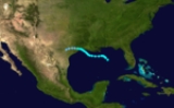
Hurricane Two
Tropical Storm Two formed off the western coast of FloridaFlorida
Florida is a state in the southeastern United States, located on the nation's Atlantic and Gulf coasts. It is bordered to the west by the Gulf of Mexico, to the north by Alabama and Georgia and to the east by the Atlantic Ocean. With a population of 18,801,310 as measured by the 2010 census, it...
on September 16 and began moving west-southwest. Operationally, the cyclone was first observed on September 18, to the south of Louisiana
Louisiana
Louisiana is a state located in the southern region of the United States of America. Its capital is Baton Rouge and largest city is New Orleans. Louisiana is the only state in the U.S. with political subdivisions termed parishes, which are local governments equivalent to counties...
. After intensifying to a Category 1 hurricane, the storm began drifting southward towards the Yucatan Peninsula
Yucatán Peninsula
The Yucatán Peninsula, in southeastern Mexico, separates the Caribbean Sea from the Gulf of Mexico, with the northern coastline on the Yucatán Channel...
, ultimately executing a clockwise loop. By September 21 it had turned northward before assuming a more northwestward course. It moved across the western Gulf of Mexico and went ashore in Texas
Texas
Texas is the second largest U.S. state by both area and population, and the largest state by area in the contiguous United States.The name, based on the Caddo word "Tejas" meaning "friends" or "allies", was applied by the Spanish to the Caddo themselves and to the region of their settlement in...
on September 23. It curved towards the northeast, passing just east of Houston
Houston, Texas
Houston is the fourth-largest city in the United States, and the largest city in the state of Texas. According to the 2010 U.S. Census, the city had a population of 2.1 million people within an area of . Houston is the seat of Harris County and the economic center of , which is the ...
, and accelerated as it continued to move inland. The cyclone transitioned into an extratropical storm on September 24, and was last recorded in southern Quebec
Quebec
Quebec or is a province in east-central Canada. It is the only Canadian province with a predominantly French-speaking population and the only one whose sole official language is French at the provincial level....
.
Warnings and advisories declared in response to the storm were widely distributed, and approximately 25,000 people in the area evacuated their homes. Officials completed various precautionary measures. Wind gusts along the coast reached up to 100 mph (160.9 km/h), and high storm tides were recorded. The hurricane inflicted severe damage; destruction to property was worth an estimated $2 million, with an additional $5 million in damage to crops, notably rice and cotton. Overall, the cyclone killed four people. The hurricane affected the southern Louisiana region one week before the Louisiana Maneuvers
Louisiana Maneuvers
The Louisiana Maneuvers were a series of military exercises held all over north and west-central Louisiana, including Fort Polk, Camp Claiborne and Camp Livingston, in August and September 1941...
, a prelude to World War II
World War II
World War II, or the Second World War , was a global conflict lasting from 1939 to 1945, involving most of the world's nations—including all of the great powers—eventually forming two opposing military alliances: the Allies and the Axis...
. Heavy rainfall triggered flooding and swelled rivers, and army vehicles became stuck in the mud as a result. The inclement weather forced hundreds of military aircraft to move inland for shelter.
Hurricane Three
Early on September 18, squally weather was reported throughout the Atlantic coast of Florida, with indications that a circulation center was present 150 mi (241.4 km) offshore. It is estimated that a tropical storm had formed at around this time. The cyclone began to intensity as it briefly moved northeastward, before abruptly executing an eastward turn. It attained Category 1 hurricane status on September 19, and completed a clockwise loop the next day. It then tracked northwestward toward North CarolinaNorth Carolina
North Carolina is a state located in the southeastern United States. The state borders South Carolina and Georgia to the south, Tennessee to the west and Virginia to the north. North Carolina contains 100 counties. Its capital is Raleigh, and its largest city is Charlotte...
, but began to recurve away from land late on September 22. It weakened into a tropical storm shortly afterward. The system dissipated on September 25 to the south of Nova Scotia
Nova Scotia
Nova Scotia is one of Canada's three Maritime provinces and is the most populous province in Atlantic Canada. The name of the province is Latin for "New Scotland," but "Nova Scotia" is the recognized, English-language name of the province. The provincial capital is Halifax. Nova Scotia is the...
. The storm had little or no effect on land, but caused significant delays for North Atlantic shipping. One vessel en route from Curaçao
Curaçao
Curaçao is an island in the southern Caribbean Sea, off the Venezuelan coast. The Country of Curaçao , which includes the main island plus the small, uninhabited island of Klein Curaçao , is a constituent country of the Kingdom of the Netherlands...
to New York
New York
New York is a state in the Northeastern region of the United States. It is the nation's third most populous state. New York is bordered by New Jersey and Pennsylvania to the south, and by Connecticut, Massachusetts and Vermont to the east...
encountered the storm on two separate occasions, recording Force 8 winds on the Beaufort scale
Beaufort scale
The Beaufort Scale is an empirical measure that relates wind speed to observed conditions at sea or on land. Its full name is the Beaufort Wind Force Scale.-History:...
both times.
Hurricane Four
On September 23, a minor area of disturbed weather was observed about 75 mi (120.7 km) to the northwest of BarbadosBarbados
Barbados is an island country in the Lesser Antilles. It is in length and as much as in width, amounting to . It is situated in the western area of the North Atlantic and 100 kilometres east of the Windward Islands and the Caribbean Sea; therein, it is about east of the islands of Saint...
. It is estimated that it developed into a tropical storm shortly thereafter. Tracking westward, it passed just south of St. Lucia and emerged into the Caribbean Sea
Caribbean Sea
The Caribbean Sea is a sea of the Atlantic Ocean located in the tropics of the Western hemisphere. It is bounded by Mexico and Central America to the west and southwest, to the north by the Greater Antilles, and to the east by the Lesser Antilles....
. By September 25, the storm had reached hurricane strength. Still intensifying, the storm continued generally westward and reached its peak at Category 3 on the Saffir-Simpson Hurricane Scale
Saffir-Simpson Hurricane Scale
The Saffir–Simpson Hurricane Scale , or the Saffir–Simpson Hurricane Wind Scale , classifies hurricanes — Western Hemisphere tropical cyclones that exceed the intensities of tropical depressions and tropical storms — into five categories distinguished by the intensities of their sustained winds...
. By September 27, the hurricane was situated near Cape Gracias a Dios, Honduras
Honduras
Honduras is a republic in Central America. It was previously known as Spanish Honduras to differentiate it from British Honduras, which became the modern-day state of Belize...
, and accelerated as it moved across the northernmost stretch of the country. After briefly entering the Gulf of Honduras
Gulf of Honduras
The Gulf or Bay of Honduras is a large inlet of the Caribbean Sea, indenting the coasts of Belize, Guatemala, and Honduras. From north to south, it runs for approximately 200 km from Dangriga, Belize, to La Ceiba, Honduras....
, it moved ashore again in the country, about 70 mi (112.7 km) south of Belize
Belize
Belize is a constitutional monarchy and the northernmost country in Central America. Belize has a diverse society, comprising many cultures and languages. Even though Kriol and Spanish are spoken among the population, Belize is the only country in Central America where English is the official...
. Gradually weakening, the storm continued inland and weakened to a tropical storm by September 29. The storm emerged over the Bay of Campeche
Bay of Campeche
The Bay of Campeche is the southern bight of the Gulf of Mexico. It is surrounded on three sides by the Mexican states of Campeche, Tabasco and Veracruz. It was named by Francisco Hernández de Córdoba and Antonio de Alaminos during their expedition in 1517...
as a tropical depression and made a final landfall on Veracruz
Veracruz
Veracruz, formally Veracruz de Ignacio de la Llave officially Estado Libre y Soberano de Veracruz de Ignacio de la Llave , is one of the 31 states that, along with the Federal District, comprise the 32 federative entities of Mexico. It is divided in 212 municipalities and its capital city is...
.
Approximately 47 lives were lost at sea due to the hurricane. The SS Ethel Sakel displayed a "sinking" message on September 25, about 125 mi (201.2 km) north of Aruba
Aruba
Aruba is a 33 km-long island of the Lesser Antilles in the southern Caribbean Sea, located 27 km north of the coast of Venezuela and 130 km east of Guajira Peninsula...
; she later went down with 20 of her 33 crew members. Two other ships sent out distress signals, one of which capsized, all hands lost. Damage on land was also extensive, and three people drowned at Cape Gracias, which was largely destroyed by the storm. Coastal flooding in the town was severe. In Belize, forests sustained major damage. For example, in the Melinda region, high winds brought down about 10% of the large pines.
Hurricane Five
Tropical Storm Five was first observed to the north of the Virgin IslandsVirgin Islands
The Virgin Islands are the western island group of the Leeward Islands, which are the northern part of the Lesser Antilles, which form the border between the Caribbean Sea and the Atlantic Ocean...
on October 3. The storm tracked generally westward through The Bahamas, reaching peak winds of 120 miles per hour (193.1 km/h), which corresponds to a Category 3 hurricane on the modern-day Saffir–Simpson Hurricane Scale. After moving across southern Florida the hurricane emerged into the Gulf of Mexico
Gulf of Mexico
The Gulf of Mexico is a partially landlocked ocean basin largely surrounded by the North American continent and the island of Cuba. It is bounded on the northeast, north and northwest by the Gulf Coast of the United States, on the southwest and south by Mexico, and on the southeast by Cuba. In...
and made another landfall
Landfall (meteorology)
Landfall is the event of a tropical cyclone or a waterspout coming onto land after being over water. When a waterspout makes landfall it is reclassified as a tornado, which can then cause damage inland...
along the Florida Panhandle
Florida Panhandle
The Florida Panhandle, an informal, unofficial term for the northwestern part of Florida, is a strip of land roughly 200 miles long and 50 to 100 miles wide , lying between Alabama on the north and the west, Georgia also on the north, and the Gulf of Mexico to the south. Its eastern boundary is...
. Turning toward the north and northeast, it crossed Georgia
Georgia (U.S. state)
Georgia is a state located in the southeastern United States. It was established in 1732, the last of the original Thirteen Colonies. The state is named after King George II of Great Britain. Georgia was the fourth state to ratify the United States Constitution, on January 2, 1788...
and South Carolina
South Carolina
South Carolina is a state in the Deep South of the United States that borders Georgia to the south, North Carolina to the north, and the Atlantic Ocean to the east. Originally part of the Province of Carolina, the Province of South Carolina was one of the 13 colonies that declared independence...
, and entered the Atlantic Ocean
Atlantic Ocean
The Atlantic Ocean is the second-largest of the world's oceanic divisions. With a total area of about , it covers approximately 20% of the Earth's surface and about 26% of its water surface area...
on October 8. The storm fully dissipated several days later.
Preparations for the storm were extensive; residents boarded up homes and businesses, while evacuations were recommended in some coastal areas. In the Bahamas, where winds reached 104 miles per hour (167.4 km/h), the storm killed three people. The city of Nassau
Nassau, Bahamas
Nassau is the capital, largest city, and commercial centre of the Commonwealth of the Bahamas. The city has a population of 248,948 , 70 percent of the entire population of The Bahamas...
was struck particularly hard. In Florida, damage was relatively severe, and included the deaths of several people. High winds brought down trees and powerlines, though the storm was characterized by highly unusual rainfall patterns. Storm surge in the Everglades
Everglades
The Everglades are subtropical wetlands in the southern portion of the U.S. state of Florida, comprising the southern half of a large watershed. The system begins near Orlando with the Kissimmee River, which discharges into the vast but shallow Lake Okeechobee...
region flooded local streets. As the storm progressed northward, the city of Tallahassee
Tallahassee, Florida
Tallahassee is the capital of the U.S. state of Florida. It is the county seat and only incorporated municipality in Leon County, and is the 128th largest city in the United States. Tallahassee became the capital of Florida, then the Florida Territory, in 1824. In 2010, the population recorded by...
suffered widespread power outages and damage to numerous vehicles. Throughout the state, the hurricane inflicted $675,000 (1941 USD) in damages. The cyclone later killed one person in Georgia.
Tropical Storm Six
A tropical storm formed on October 15, and passed through the southern Bahamas. It crossed the Florida Straits, and reached its peak intensity with winds of 50 mph (85 km/h) on October 20, after entering the eastern Gulf of Mexico and turning towards the north. It curved northeastward and made landfall at Cedar Key, FloridaCedar Key, Florida
Cedar Key is a city in Levy County, Florida, United States. The population was 790 at the 2000 census. According to the U.S Census estimates of 2005, the city had a population of 958. The Cedar Keys are a cluster of islands close to the mainland. Most of the developed area of the city has been on...
. After pushing inland, the storm stalled and weakened to a tropical depression on October 21 before dissipating fully the next day.
The storm's slow forward motion over the state of Florida led to heavy widespread precipitation, locally amounting to 10 to 15 in (254 to 381 mm). Gale-force winds were also reported. Some flood damage occurred throughout the affected locations. An infant was killed following the destruction of a house, possibly related to a tornado
Tornado
A tornado is a violent, dangerous, rotating column of air that is in contact with both the surface of the earth and a cumulonimbus cloud or, in rare cases, the base of a cumulus cloud. They are often referred to as a twister or a cyclone, although the word cyclone is used in meteorology in a wider...
spawned by the tropical storm; the baby's parents also sustained injuries.
See also
- List of tropical cyclones
- List of Atlantic hurricane seasons