

Nags Head, North Carolina
Encyclopedia
Nags Head is a town in Dare County
, North Carolina
, United States
. The population was 2,700 at the 2000 census.
. The origin of the town's name is obscure but it may have been named after Nag's Head Island, an island in the River Thames in England at Abingdon
. Another possible source of the name was in reference to the lights hung on mules' heads by "wreckers"
who would lead ships to be shipwrecked near shore where the economically challenged could loot the ships of their valuables.
Around 1830, Nags Head became known as a resort area, and so remains today. Jockey's Ridge is the last vestige of the sand dunes seen by the first explorers, as the area is now highly developed.
According to the United States Census Bureau
, the town has a total area of 6.6 square miles (17.1 km²), of which, 6.5 square miles (16.8 km²) of it is land and 0.1 square mile (0.258998811 km²) of it (1.51%) is water.
of 2000, there were 2,700 people, 1,138 households, and 726 families residing in the town. The population density
was 413.2 people per square mile (159.4/km²). There were 4,149 housing units at an average density of 634.9 per square mile (244.9/km²). The racial makeup of the town was 96.96% White, 1.33% African American, 0.15% Native American, 0.44% Asian, 0.48% from other races
, and 0.63% from two or more races. Hispanic or Latino of any race were 1.44% of the population.
There were 1,138 households out of which 25.9% had children under the age of 18 living with them, 54.0% were married couples
living together, 6.7% had a female householder with no husband present, and 36.2% were non-families. 26.0% of all households were made up of individuals and 7.6% had someone living alone who was 65 years of age or older. The average household size was 2.26 and the average family size was 2.71.
In the town the population was spread out with 19.2% under the age of 18, 5.1% from 18 to 24, 30.7% from 25 to 44, 28.0% from 45 to 64, and 17.0% who were 65 years of age or older. The median age was 43 years. For every 100 females there were 98.1 males. For every 100 females age 18 and over, there were 99.4 males.
The median income for a household in the town was $53,095, and the median income for a family was $61,302. Males had a median income of $33,289 versus $30,139 for females. The per capita income
for the town was $30,157. About 4.4% of families and 6.1% of the population were below the poverty line, including 7.9% of those under age 18 and 4.3% of those age 65 or over.
, and has buried a miniature golf course along the way. A castle is still visible and is a major landmark. Also buried is The Old Nags Head Hotel. The area surrounding Jockey's Ridge is good for biking, or hiking. Jockey's Ridge has been popular with Hang-gliders since the advent of the sport, as well as kite flyers and sand gliders. The Ridge includes an informative museum with exhibits on sand, weather, and area animals. The creatures outside are numerous and includes bird species, foxes, mice, squirrels, occasional deer and friendly wild rabbits. One of the most exciting features of the Ridge is its capriciousness. Annual visitors find that lagoons can spring up, and the sand can shift making for a fresh experience every time. From the top of the Ridge, the ocean as well as the sound can be seen. Jockey's Ridge has a sound beach on the Roanoke Sound side that visitors can swim in.
The Nags Head Woods Ecological Preserve is 1092 acres (4.4 km²) and lies North of Jockey's Ridge and east of Roanoke Sound
. It was designated a National Natural Landmark
in 1974.
As in any other beach town, the ocean and shoreline are the major attractions, providing beaches for swimming, sunbathing, and a variety of water sports. A series of historic cottages overlook the beach in sections. There are three piers, Nags Head Pier, Jennette's Pier (destroyed by Hurricane Isabel
in 2003 and bought and renovated by the North Carolina Aquariums
; it reopened in May 2011), and Outer Banks Pier which are popular for fishing. The town also features miniature golf courses and small amusement centers with go-karts and bumper cars for family entertainment.
Other attractions include various National Register of Historic Places in or near Nags Head, such as the following:
Dare County, North Carolina
-National protected areas:* Alligator River National Wildlife Refuge * Cape Hatteras National Seashore * Fort Raleigh National Historic Site* Pea Island National Wildlife Refuge* Wright Brothers National Memorial-Demographics:...
, North Carolina
North Carolina
North Carolina is a state located in the southeastern United States. The state borders South Carolina and Georgia to the south, Tennessee to the west and Virginia to the north. North Carolina contains 100 counties. Its capital is Raleigh, and its largest city is Charlotte...
, United States
United States
The United States of America is a federal constitutional republic comprising fifty states and a federal district...
. The population was 2,700 at the 2000 census.
History
Early maps of the area show Nags Head as a promontory of land characterized by high sand dunes visible from miles at seaSea
A sea generally refers to a large body of salt water, but the term is used in other contexts as well. Most commonly, it means a large expanse of saline water connected with an ocean, and is commonly used as a synonym for ocean...
. The origin of the town's name is obscure but it may have been named after Nag's Head Island, an island in the River Thames in England at Abingdon
Abingdon, Oxfordshire
Abingdon or archaically Abingdon-on-Thames is a market town and civil parish in Oxfordshire, England. It is the seat of the Vale of White Horse district. Previously the county town of Berkshire, Abingdon is one of several places that claim to be Britain's oldest continuously occupied town, with...
. Another possible source of the name was in reference to the lights hung on mules' heads by "wreckers"
Wrecking (shipwreck)
Wrecking is the practice of taking valuables from a shipwreck which has foundered near or close to shore. Often an unregulated activity of opportunity in coastal communities, wrecking has been subjected to increasing regulation and evolved into what is now known as marine salvage...
who would lead ships to be shipwrecked near shore where the economically challenged could loot the ships of their valuables.
Around 1830, Nags Head became known as a resort area, and so remains today. Jockey's Ridge is the last vestige of the sand dunes seen by the first explorers, as the area is now highly developed.
Geography
Nags Head is located at 35°55′55"N 75°36′54"W (35.932004, -75.615085).According to the United States Census Bureau
United States Census Bureau
The United States Census Bureau is the government agency that is responsible for the United States Census. It also gathers other national demographic and economic data...
, the town has a total area of 6.6 square miles (17.1 km²), of which, 6.5 square miles (16.8 km²) of it is land and 0.1 square mile (0.258998811 km²) of it (1.51%) is water.
Demographics
As of the censusCensus
A census is the procedure of systematically acquiring and recording information about the members of a given population. It is a regularly occurring and official count of a particular population. The term is used mostly in connection with national population and housing censuses; other common...
of 2000, there were 2,700 people, 1,138 households, and 726 families residing in the town. The population density
Population density
Population density is a measurement of population per unit area or unit volume. It is frequently applied to living organisms, and particularly to humans...
was 413.2 people per square mile (159.4/km²). There were 4,149 housing units at an average density of 634.9 per square mile (244.9/km²). The racial makeup of the town was 96.96% White, 1.33% African American, 0.15% Native American, 0.44% Asian, 0.48% from other races
Race (United States Census)
Race and ethnicity in the United States Census, as defined by the Federal Office of Management and Budget and the United States Census Bureau, are self-identification data items in which residents choose the race or races with which they most closely identify, and indicate whether or not they are...
, and 0.63% from two or more races. Hispanic or Latino of any race were 1.44% of the population.
There were 1,138 households out of which 25.9% had children under the age of 18 living with them, 54.0% were married couples
Marriage
Marriage is a social union or legal contract between people that creates kinship. It is an institution in which interpersonal relationships, usually intimate and sexual, are acknowledged in a variety of ways, depending on the culture or subculture in which it is found...
living together, 6.7% had a female householder with no husband present, and 36.2% were non-families. 26.0% of all households were made up of individuals and 7.6% had someone living alone who was 65 years of age or older. The average household size was 2.26 and the average family size was 2.71.
In the town the population was spread out with 19.2% under the age of 18, 5.1% from 18 to 24, 30.7% from 25 to 44, 28.0% from 45 to 64, and 17.0% who were 65 years of age or older. The median age was 43 years. For every 100 females there were 98.1 males. For every 100 females age 18 and over, there were 99.4 males.
The median income for a household in the town was $53,095, and the median income for a family was $61,302. Males had a median income of $33,289 versus $30,139 for females. The per capita income
Per capita income
Per capita income or income per person is a measure of mean income within an economic aggregate, such as a country or city. It is calculated by taking a measure of all sources of income in the aggregate and dividing it by the total population...
for the town was $30,157. About 4.4% of families and 6.1% of the population were below the poverty line, including 7.9% of those under age 18 and 4.3% of those age 65 or over.
Attractions
Located in Nags Head is the largest sand dune on the East Coast, Jockey's Ridge. The sand dune has migrated over the years from wind and erosionErosion
Erosion is when materials are removed from the surface and changed into something else. It only works by hydraulic actions and transport of solids in the natural environment, and leads to the deposition of these materials elsewhere...
, and has buried a miniature golf course along the way. A castle is still visible and is a major landmark. Also buried is The Old Nags Head Hotel. The area surrounding Jockey's Ridge is good for biking, or hiking. Jockey's Ridge has been popular with Hang-gliders since the advent of the sport, as well as kite flyers and sand gliders. The Ridge includes an informative museum with exhibits on sand, weather, and area animals. The creatures outside are numerous and includes bird species, foxes, mice, squirrels, occasional deer and friendly wild rabbits. One of the most exciting features of the Ridge is its capriciousness. Annual visitors find that lagoons can spring up, and the sand can shift making for a fresh experience every time. From the top of the Ridge, the ocean as well as the sound can be seen. Jockey's Ridge has a sound beach on the Roanoke Sound side that visitors can swim in.
The Nags Head Woods Ecological Preserve is 1092 acres (4.4 km²) and lies North of Jockey's Ridge and east of Roanoke Sound
Roanoke Sound
The Roanoke Sound is a sound that separates Roanoke Island from Bodie Island of the Outer Banks. To the north of the Roanoke Sound lies the Albemarle Sound and to the south lies the Pamlico Sound. One bridge, which carries U.S. Highway 64, crosses the sound....
. It was designated a National Natural Landmark
National Natural Landmark
The National Natural Landmark program recognizes and encourages the conservation of outstanding examples of the natural history of the United States. It is the only natural areas program of national scope that identifies and recognizes the best examples of biological and geological features in...
in 1974.
As in any other beach town, the ocean and shoreline are the major attractions, providing beaches for swimming, sunbathing, and a variety of water sports. A series of historic cottages overlook the beach in sections. There are three piers, Nags Head Pier, Jennette's Pier (destroyed by Hurricane Isabel
Hurricane Isabel
Hurricane Isabel was the costliest and deadliest hurricane in the 2003 Atlantic hurricane season. The ninth named storm, fifth hurricane, and second major hurricane of the season, Isabel formed near the Cape Verde Islands from a tropical wave on September 6 in the tropical Atlantic Ocean...
in 2003 and bought and renovated by the North Carolina Aquariums
North Carolina Aquariums
North Carolina Aquariums is a system of 3 public aquariums located in Kure Beach, Roanoke Island and Pine Knoll Shores. All are operated by the Aquariums Division of the North Carolina Department of Environment and Natural Resources since 1976 and are accredited by the Association of Zoos and...
; it reopened in May 2011), and Outer Banks Pier which are popular for fishing. The town also features miniature golf courses and small amusement centers with go-karts and bumper cars for family entertainment.
Other attractions include various National Register of Historic Places in or near Nags Head, such as the following:
| Landmark name | Image | Date listed | Location | Notes |
|---|---|---|---|---|
| Bodie Island Lifesaving and Coast Guard Station Bodie Island Lifesaving and Coast Guard Station The Bodie Island Lifesaving Station, also known as the Bodie Island Coast Guard Station, is located on the Outer Banks of North Carolina at the southern end of Bodie Island, within Cape Hatteras National Seashore. The district includes a residence, the lifesaving station, the Coast Guard station,... |
.jpg) |
S of Nags Head on NC 12 35°50′11"N 75°33′33"W |
||
| Bodie Island Light Station Bodie Island Light The current Bodie Island Lighthouse is the third that has stood in this vicinity of Bodie Island on the Outer Banks in North Carolina and was built in 1872. It stands tall and is located on the Roanoke Sound side of the first island that is part of the Cape Hatteras National Seashore. The... |
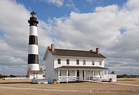 |
Off NC 12 35°49′12"N 75°33′49"W |
||
| First Colony Inn | 6720 S. Virginia Dare Trail 35°55′6"N 75°36′13"W |
|||
| Markham-Albertson-Stinson Cottage | 4300 W. Soundside Rd. 35°56′45.51"N 75°37′45.93"W |
Destroyed by Hurricane Irene Hurricane Irene (2011) Hurricane Irene was a large and powerful Atlantic hurricane that left extensive flood and wind damage along its path through the Caribbean, the United States East Coast and as far north as Atlantic Canada in 2011... |
||
| Mattie Midgett Store and House | 4008 S. Virginia Dare Trail 35°57′23"N 75°37′28"W |
|||
| Nags Head Beach Cottages Historic District | U.S. 158 U.S. Route 158 U.S. Route 158 is an east–west United States highway that runs for from Mocksville to Nags Head, entirely in the U.S. state of North Carolina.-Route description:... 35°57′50"N 75°35′49"W |
|||
| Sea Foam Motel | 7111 S. Virginia Dare Trail 35°54′37"N 75°35′47"W |
|||
| USS Huron USS Huron (1875) USS Huron, was an iron sloop-rigged screw steam gunboat built by John Roach & Sons in Chester, Pennsylvania from 1873–75 and commissioned at Philadelphia Navy Yard on 15 November 1875, Commander George P... |
Address restricted |
External links
- Official website of Nags Head, NC
- Webcams: Nags Head - East and Nags Head - West from outerbanks.net
- "The Beginning of New hope Church, Nags Head Chapel from nhumc.info