
1939 Atlantic hurricane season
Encyclopedia
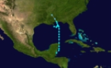
The 1939 Atlantic hurricane season officially began on June 16, 1939, and lasted until October 31, 1939. These dates mark the period of each year when most tropical cyclone
s form in the Atlantic basin
. The 1939 season
had below normal activity, with only five tropical storms
, of which two became hurricanes and one became a major hurricane, equivalent to Category 3 status or higher on the modern-day Saffir-Simpson Hurricane Scale
. The first tropical cyclone formed on June 12, and the last dissipated on November 6.
All of the storms affected land to some extent. The first three cyclones of the season made landfall along the coast of the United States
, collectively causing only minor damage. Hurricane Four, the strongest of the year, took a northeastern path through the western Atlantic, striking Bermuda on October 16. The fifth and final storm was a minimal hurricane that wrought damage throughout the western Caribbean Sea
, most notably in Jamaica
and Cuba
. The weakest known storm was Tropical Storm Three, with winds of only 45 mph (70 km/h) and a minimum barometric pressure of 1003 mbar (hPa).
on June 12. Reports of the storm first came from the Mexican Weather Service office in Chetumal, Quintana Roo, and during the afternoon of June 12, vessels just offshore recorded squally conditions and choppy seas. The cyclone moved northward, parallel to the coast of Belize
, before moving over the northeastern corner of the Yucatán Peninsula
. It continued steadily northward through the Gulf of Mexico
, slowly strengthening to a peak of 50 miles per hour (80.5 km/h) on June 14 with a minimum central pressure of 1000 hectopascals (29.5 inHg). An area of high pressure
to the north caused the storm to execute a counter-clockwise loop. A trough of low pressure turned it back to the north, and the cyclone made landfall near Mobile, Alabama
, as a minimal tropical storm on June 16. Turning to the northwest, it quickly weakened to a tropical depression and dissipated on June 17 over Mississippi
.
In advance of the system, officials issued storm warnings for coastal areas of Alabama and western Florida, and residents in low-lying areas were advised to seek higher ground. Damage associated with the cyclone was generally minor, and only one life was lost when a boy fell into the swollen waters of a river and drowned.
, likely from a tropical wave. It tracked to the west-northwest, slowly strengthening to a hurricane as it moved through the Bahamas on August 11. Later that day, it met the east coast of Florida, and crossed the state in around 15 hours. After weakening to a tropical storm, it quickly re-strengthened upon emerging into the Gulf of Mexico, and made another landfall near Apalachicola, Florida
, on August 13. Over land, the cyclone slowed considerably and quickly deteriorated. By August 14, the storm had weakened to a tropical depression as it drifted through Alabama
. The depression turned to the northeast, and remained a tropical depression until it dissipated over New York
on August 20. Due to timely reports and warnings, the storm was reportedly forecast with "exceptional accuracy".
In Florida, damage was minor, amounting to uprooted trees, broken windows, moderate crop damage, and downed power lines. A few flimsy structures and small watercraft also sustained damage. Along the Florida Panhandle
, the storm's winds impacted power, telephone, and telegraph lines, and inflicted $2,000 worth of damage to a dock warehouse. A man in Cedar Key, Florida
, drowned after rough surf overturned his rowboat, and at least two other people suffered minor storm-related injuries. Torrential rain fell in Alabama as a result of the storm's slow forward movement, leading to severe flooding. Further inland, the storm spawned a tornado in North Carolina
which caused one death. As the depression continued heading inland, it dropped heavy precipitation throughout the Mid-Atlantic States
, exceeding 14 inches (35.6 cm) in Tuckerton, New Jersey
.
organized into a tropical storm in the Bay of Campeche
on September 23. Uneventfully, it moved generally north-northeastward through the Gulf of Mexico
and its winds strengthened to a peak of 45 miles per hour (72.4 km/h). The storm made landfall on south-central Louisiana
on September 26, and dissipated later that day. The Weather Bureau office in New Orleans posted numerous advisories, although the effects from the storm were minimal.
of low pressures and unsettled weather indicated that a storm was forming in the vicinity. The disturbance strengthened into a tropical storm on October 12 to the northeast of Puerto Rico
. The quickly escalating storm tracked northwestward before turning towards the northeast, away from a high pressure area
building in from the west. Early on October 15, the storm attained hurricane intensity and continued to mature until October 16, when it reached its peak at a strength corresponding to Category 4 status on the modern-day Saffir-Simpson Hurricane Scale
. That same day it passed just east of Bermuda
. It weakened as it accelerated to the northeast, and became extratropical near Newfoundland a couple of days later.
Numerous ships encountered the hurricane along its course. On the President Harding, en route to New York, one crew member drowned due to the rough conditions and 73 crew and passengers suffered injury, of various severity, requiring a call for emergency medical supplies. The ship itself sustained a bit of damage. As the storm passed near the island of Bermuda, it generated strong winds—gusting to 131 miles per hour (210.8 km/h)—and heavy precipitation. Damage was fairly significant; the winds uprooted trees, shattered windows, and disrupted public utilities.
. It initially moved northwestward, but turned toward the east shortly thereafter. Drifting due eastward, the storm grew into a minimal hurricane on October 31 while passing over the Cayman Islands
. The hurricane's center passed just north of the island of Jamaica
later that day as it weakened back into a tropical storm. Eventually, the storm turned abruptly northeastward and crossed the eastern tip of Cuba
. By November 3, it had emerged into the Atlantic and entered the southern Bahamas. Beginning to accelerate, the tropical storm passed to the west of Bermuda before becoming extratropical on November 6.
At Grand Cayman
, winds from the storm reached 92 miles per hour (148.1 km/h) with a minimum pressure of 990 hectopascals (29.2 inHg). According to press reports, the hurricane inflicted considerable damage on the Cayman Islands. In northern Jamaica, property damage was also widespread. The hurricane brought heavy rainfall, high winds, and pounding surf to the island, leaving one dead. Another death was reported in Cuba, where the torrential rains also caused extensive flooding and losses to livestock and crops.
Tropical cyclone
A tropical cyclone is a storm system characterized by a large low-pressure center and numerous thunderstorms that produce strong winds and heavy rain. Tropical cyclones strengthen when water evaporated from the ocean is released as the saturated air rises, resulting in condensation of water vapor...
s form in the Atlantic basin
Atlantic Basin
The Atlantic Basin is the Atlantic Ocean.Atlantic Basin may also refer to:* Atlantic Basin Iron Works, an ironworks that operated in Brooklyn, New York, in the early to mid-20th century...
. The 1939 season
Atlantic hurricane season
The Atlantic hurricane season is the period in a year when hurricanes usually form in the Atlantic Ocean. Tropical cyclones in the North Atlantic are called hurricanes, tropical storms, or tropical depressions. In addition, there have been several storms over the years that have not been fully...
had below normal activity, with only five tropical storms
Tropical cyclone
A tropical cyclone is a storm system characterized by a large low-pressure center and numerous thunderstorms that produce strong winds and heavy rain. Tropical cyclones strengthen when water evaporated from the ocean is released as the saturated air rises, resulting in condensation of water vapor...
, of which two became hurricanes and one became a major hurricane, equivalent to Category 3 status or higher on the modern-day Saffir-Simpson Hurricane Scale
Saffir-Simpson Hurricane Scale
The Saffir–Simpson Hurricane Scale , or the Saffir–Simpson Hurricane Wind Scale , classifies hurricanes — Western Hemisphere tropical cyclones that exceed the intensities of tropical depressions and tropical storms — into five categories distinguished by the intensities of their sustained winds...
. The first tropical cyclone formed on June 12, and the last dissipated on November 6.
All of the storms affected land to some extent. The first three cyclones of the season made landfall along the coast of the United States
United States
The United States of America is a federal constitutional republic comprising fifty states and a federal district...
, collectively causing only minor damage. Hurricane Four, the strongest of the year, took a northeastern path through the western Atlantic, striking Bermuda on October 16. The fifth and final storm was a minimal hurricane that wrought damage throughout the western Caribbean Sea
Caribbean Sea
The Caribbean Sea is a sea of the Atlantic Ocean located in the tropics of the Western hemisphere. It is bounded by Mexico and Central America to the west and southwest, to the north by the Greater Antilles, and to the east by the Lesser Antilles....
, most notably in Jamaica
Jamaica
Jamaica is an island nation of the Greater Antilles, in length, up to in width and 10,990 square kilometres in area. It is situated in the Caribbean Sea, about south of Cuba, and west of Hispaniola, the island harbouring the nation-states Haiti and the Dominican Republic...
and Cuba
Cuba
The Republic of Cuba is an island nation in the Caribbean. The nation of Cuba consists of the main island of Cuba, the Isla de la Juventud, and several archipelagos. Havana is the largest city in Cuba and the country's capital. Santiago de Cuba is the second largest city...
. The weakest known storm was Tropical Storm Three, with winds of only 45 mph (70 km/h) and a minimum barometric pressure of 1003 mbar (hPa).
Tropical Storm One
The first tropical storm of the season developed in the extreme western Caribbean SeaCaribbean Sea
The Caribbean Sea is a sea of the Atlantic Ocean located in the tropics of the Western hemisphere. It is bounded by Mexico and Central America to the west and southwest, to the north by the Greater Antilles, and to the east by the Lesser Antilles....
on June 12. Reports of the storm first came from the Mexican Weather Service office in Chetumal, Quintana Roo, and during the afternoon of June 12, vessels just offshore recorded squally conditions and choppy seas. The cyclone moved northward, parallel to the coast of Belize
Belize
Belize is a constitutional monarchy and the northernmost country in Central America. Belize has a diverse society, comprising many cultures and languages. Even though Kriol and Spanish are spoken among the population, Belize is the only country in Central America where English is the official...
, before moving over the northeastern corner of the Yucatán Peninsula
Yucatán Peninsula
The Yucatán Peninsula, in southeastern Mexico, separates the Caribbean Sea from the Gulf of Mexico, with the northern coastline on the Yucatán Channel...
. It continued steadily northward through the Gulf of Mexico
Gulf of Mexico
The Gulf of Mexico is a partially landlocked ocean basin largely surrounded by the North American continent and the island of Cuba. It is bounded on the northeast, north and northwest by the Gulf Coast of the United States, on the southwest and south by Mexico, and on the southeast by Cuba. In...
, slowly strengthening to a peak of 50 miles per hour (80.5 km/h) on June 14 with a minimum central pressure of 1000 hectopascals (29.5 inHg). An area of high pressure
High pressure area
A high-pressure area is a region where the atmospheric pressure at the surface of the planet is greater than its surrounding environment. Winds within high-pressure areas flow outward due to the higher density air near their center and friction with land...
to the north caused the storm to execute a counter-clockwise loop. A trough of low pressure turned it back to the north, and the cyclone made landfall near Mobile, Alabama
Mobile, Alabama
Mobile is the third most populous city in the Southern US state of Alabama and is the county seat of Mobile County. It is located on the Mobile River and the central Gulf Coast of the United States. The population within the city limits was 195,111 during the 2010 census. It is the largest...
, as a minimal tropical storm on June 16. Turning to the northwest, it quickly weakened to a tropical depression and dissipated on June 17 over Mississippi
Mississippi
Mississippi is a U.S. state located in the Southern United States. Jackson is the state capital and largest city. The name of the state derives from the Mississippi River, which flows along its western boundary, whose name comes from the Ojibwe word misi-ziibi...
.
In advance of the system, officials issued storm warnings for coastal areas of Alabama and western Florida, and residents in low-lying areas were advised to seek higher ground. Damage associated with the cyclone was generally minor, and only one life was lost when a boy fell into the swollen waters of a river and drowned.
Hurricane Two
On August 7, a tropical storm formed north of the Leeward IslandsLeeward Islands
The Leeward Islands are a group of islands in the West Indies. They are the northern islands of the Lesser Antilles chain. As a group they start east of Puerto Rico and reach southward to Dominica. They are situated where the northeastern Caribbean Sea meets the western Atlantic Ocean...
, likely from a tropical wave. It tracked to the west-northwest, slowly strengthening to a hurricane as it moved through the Bahamas on August 11. Later that day, it met the east coast of Florida, and crossed the state in around 15 hours. After weakening to a tropical storm, it quickly re-strengthened upon emerging into the Gulf of Mexico, and made another landfall near Apalachicola, Florida
Apalachicola, Florida
Apalachicola is a city in Franklin County, Florida, on US 98 about southwest of Tallahassee. The population was 2,334 at the 2000 census. The 2005 census estimated the city's population at 2,340...
, on August 13. Over land, the cyclone slowed considerably and quickly deteriorated. By August 14, the storm had weakened to a tropical depression as it drifted through Alabama
Alabama
Alabama is a state located in the southeastern region of the United States. It is bordered by Tennessee to the north, Georgia to the east, Florida and the Gulf of Mexico to the south, and Mississippi to the west. Alabama ranks 30th in total land area and ranks second in the size of its inland...
. The depression turned to the northeast, and remained a tropical depression until it dissipated over New York
New York
New York is a state in the Northeastern region of the United States. It is the nation's third most populous state. New York is bordered by New Jersey and Pennsylvania to the south, and by Connecticut, Massachusetts and Vermont to the east...
on August 20. Due to timely reports and warnings, the storm was reportedly forecast with "exceptional accuracy".
In Florida, damage was minor, amounting to uprooted trees, broken windows, moderate crop damage, and downed power lines. A few flimsy structures and small watercraft also sustained damage. Along the Florida Panhandle
Florida Panhandle
The Florida Panhandle, an informal, unofficial term for the northwestern part of Florida, is a strip of land roughly 200 miles long and 50 to 100 miles wide , lying between Alabama on the north and the west, Georgia also on the north, and the Gulf of Mexico to the south. Its eastern boundary is...
, the storm's winds impacted power, telephone, and telegraph lines, and inflicted $2,000 worth of damage to a dock warehouse. A man in Cedar Key, Florida
Cedar Key, Florida
Cedar Key is a city in Levy County, Florida, United States. The population was 790 at the 2000 census. According to the U.S Census estimates of 2005, the city had a population of 958. The Cedar Keys are a cluster of islands close to the mainland. Most of the developed area of the city has been on...
, drowned after rough surf overturned his rowboat, and at least two other people suffered minor storm-related injuries. Torrential rain fell in Alabama as a result of the storm's slow forward movement, leading to severe flooding. Further inland, the storm spawned a tornado in North Carolina
North Carolina
North Carolina is a state located in the southeastern United States. The state borders South Carolina and Georgia to the south, Tennessee to the west and Virginia to the north. North Carolina contains 100 counties. Its capital is Raleigh, and its largest city is Charlotte...
which caused one death. As the depression continued heading inland, it dropped heavy precipitation throughout the Mid-Atlantic States
Mid-Atlantic States
The Mid-Atlantic states, also called middle Atlantic states or simply the mid Atlantic, form a region of the United States generally located between New England and the South...
, exceeding 14 inches (35.6 cm) in Tuckerton, New Jersey
Tuckerton, New Jersey
Tuckerton is a Borough in Ocean County, New Jersey, named for founder Ebenezer Tucker , and was a port of entry, but not the third Port of Entry as commonly believed, in the United States As of the 2000 United States Census, the borough population was 3,517.Tuckerton was incorporated as a borough...
.
Tropical Storm Three
An area of disturbed weather over Central AmericaCentral America
Central America is the central geographic region of the Americas. It is the southernmost, isthmian portion of the North American continent, which connects with South America on the southeast. When considered part of the unified continental model, it is considered a subcontinent...
organized into a tropical storm in the Bay of Campeche
Bay of Campeche
The Bay of Campeche is the southern bight of the Gulf of Mexico. It is surrounded on three sides by the Mexican states of Campeche, Tabasco and Veracruz. It was named by Francisco Hernández de Córdoba and Antonio de Alaminos during their expedition in 1517...
on September 23. Uneventfully, it moved generally north-northeastward through the Gulf of Mexico
Gulf of Mexico
The Gulf of Mexico is a partially landlocked ocean basin largely surrounded by the North American continent and the island of Cuba. It is bounded on the northeast, north and northwest by the Gulf Coast of the United States, on the southwest and south by Mexico, and on the southeast by Cuba. In...
and its winds strengthened to a peak of 45 miles per hour (72.4 km/h). The storm made landfall on south-central Louisiana
Louisiana
Louisiana is a state located in the southern region of the United States of America. Its capital is Baton Rouge and largest city is New Orleans. Louisiana is the only state in the U.S. with political subdivisions termed parishes, which are local governments equivalent to counties...
on September 26, and dissipated later that day. The Weather Bureau office in New Orleans posted numerous advisories, although the effects from the storm were minimal.
Hurricane Four
On the afternoon of October 9, reports from the Leeward IslandsLeeward Islands
The Leeward Islands are a group of islands in the West Indies. They are the northern islands of the Lesser Antilles chain. As a group they start east of Puerto Rico and reach southward to Dominica. They are situated where the northeastern Caribbean Sea meets the western Atlantic Ocean...
of low pressures and unsettled weather indicated that a storm was forming in the vicinity. The disturbance strengthened into a tropical storm on October 12 to the northeast of Puerto Rico
Puerto Rico
Puerto Rico , officially the Commonwealth of Puerto Rico , is an unincorporated territory of the United States, located in the northeastern Caribbean, east of the Dominican Republic and west of both the United States Virgin Islands and the British Virgin Islands.Puerto Rico comprises an...
. The quickly escalating storm tracked northwestward before turning towards the northeast, away from a high pressure area
High pressure area
A high-pressure area is a region where the atmospheric pressure at the surface of the planet is greater than its surrounding environment. Winds within high-pressure areas flow outward due to the higher density air near their center and friction with land...
building in from the west. Early on October 15, the storm attained hurricane intensity and continued to mature until October 16, when it reached its peak at a strength corresponding to Category 4 status on the modern-day Saffir-Simpson Hurricane Scale
Saffir-Simpson Hurricane Scale
The Saffir–Simpson Hurricane Scale , or the Saffir–Simpson Hurricane Wind Scale , classifies hurricanes — Western Hemisphere tropical cyclones that exceed the intensities of tropical depressions and tropical storms — into five categories distinguished by the intensities of their sustained winds...
. That same day it passed just east of Bermuda
Bermuda
Bermuda is a British overseas territory in the North Atlantic Ocean. Located off the east coast of the United States, its nearest landmass is Cape Hatteras, North Carolina, about to the west-northwest. It is about south of Halifax, Nova Scotia, Canada, and northeast of Miami, Florida...
. It weakened as it accelerated to the northeast, and became extratropical near Newfoundland a couple of days later.
Numerous ships encountered the hurricane along its course. On the President Harding, en route to New York, one crew member drowned due to the rough conditions and 73 crew and passengers suffered injury, of various severity, requiring a call for emergency medical supplies. The ship itself sustained a bit of damage. As the storm passed near the island of Bermuda, it generated strong winds—gusting to 131 miles per hour (210.8 km/h)—and heavy precipitation. Damage was fairly significant; the winds uprooted trees, shattered windows, and disrupted public utilities.
Hurricane Five
On October 29, the fifth and final known tropical cyclone of the season developed in the western Caribbean Sea from a tropical waveTropical wave
Tropical waves, easterly waves, or tropical easterly waves, also known as African easterly waves in the Atlantic region, are a type of atmospheric trough, an elongated area of relatively low air pressure, oriented north to south, which move from east to west across the tropics causing areas of...
. It initially moved northwestward, but turned toward the east shortly thereafter. Drifting due eastward, the storm grew into a minimal hurricane on October 31 while passing over the Cayman Islands
Cayman Islands
The Cayman Islands is a British Overseas Territory and overseas territory of the European Union located in the western Caribbean Sea. The territory comprises the three islands of Grand Cayman, Cayman Brac, and Little Cayman, located south of Cuba and northwest of Jamaica...
. The hurricane's center passed just north of the island of Jamaica
Jamaica
Jamaica is an island nation of the Greater Antilles, in length, up to in width and 10,990 square kilometres in area. It is situated in the Caribbean Sea, about south of Cuba, and west of Hispaniola, the island harbouring the nation-states Haiti and the Dominican Republic...
later that day as it weakened back into a tropical storm. Eventually, the storm turned abruptly northeastward and crossed the eastern tip of Cuba
Cuba
The Republic of Cuba is an island nation in the Caribbean. The nation of Cuba consists of the main island of Cuba, the Isla de la Juventud, and several archipelagos. Havana is the largest city in Cuba and the country's capital. Santiago de Cuba is the second largest city...
. By November 3, it had emerged into the Atlantic and entered the southern Bahamas. Beginning to accelerate, the tropical storm passed to the west of Bermuda before becoming extratropical on November 6.
At Grand Cayman
Grand Cayman
Grand Cayman is the largest of the three Cayman Islands and the location of the nation's capital, George Town. In relation to the other two Cayman Islands, it is approximately 75 miles southwest of Little Cayman and 90 miles southwest of Cayman Brac.-Geography:Grand Cayman encompasses 76% of...
, winds from the storm reached 92 miles per hour (148.1 km/h) with a minimum pressure of 990 hectopascals (29.2 inHg). According to press reports, the hurricane inflicted considerable damage on the Cayman Islands. In northern Jamaica, property damage was also widespread. The hurricane brought heavy rainfall, high winds, and pounding surf to the island, leaving one dead. Another death was reported in Cuba, where the torrential rains also caused extensive flooding and losses to livestock and crops.
See also
- List of tropical cyclones
- List of Atlantic hurricane seasons