

Dere Street
Encyclopedia
Dere Street or Deere Street, (latterly Via Regia in Scotland) was a Roman road between Eboracum
(York) and Veluniate
, in what is now Scotland
. It still exists in the form of the route of many major roads, including the A1 and A68
just north of Corbridge
.
Its name corresponds with the post Roman Anglo-Saxon
kingdom of Deira
, through which the first part of its route lies. It was sometimes referred to as "Watling Street" and marked on some maps as such. This can sometimes cause it to be confused with the Watling Street
that linked Dover
with Wroxeter
.
near Isurium Brigantum
(present-day Aldborough
close to Boroughbridge
). From there, it crossed the River Swale
near Catterick, North Yorkshire
, where the Roman fort was called Cataractonium. (Just north of Catterick (at the modern Scotch Corner
) the road over Stainmore
to Penrith
, Carlisle and the Western end of Hadrian's Wall branched off).
near the Roman fort of Piercebridge
by a stone arch bridge: These are relatively rare in Roman Britain, except for Hadrian's Wall and Dere Street. The original bridge at Piercebridge was replaced by another on a different alignment, and there is some evidence for other minor realignments of Dere Street over the Roman period. Raymond Selkirk has suggested that the supposed remains of a Roman
stone bridge on the south side of the Tees
at Cliffe are remains of a jetty, and Time Team
investigated this in 2009. In 1994, a section through Dere Street was exposed by excavations carried out in a garage development area at Cliffe, and some pottery and tile found.
at the Roman fort of Vinovia, near present-day Bishop Auckland
. At this point another road branched away to the right, heading for Durham
, Chester-le-Street
and eventually crossing the Tyne at Pons Aelius
the modern Newcastle
.
From Vinovia, Dere Street travelled onwards past the Roman forts of Longovicium
(present-day Lanchester
) and Vindomora
(present-day Ebchester
), before crossing the River Tyne
near the fort of Coria (Corbridge)
, where it crossed Stanegate
. Just North of Corbridge, the route passed through the fortifications of Hadrian's Wall
, at a point now known as Portgate, and passed into lands that were only tenuously under Roman domination.
From the Wall, the route continued north into Redesdale
and thence to the Cheviot Hills
, where there are the remains of marching forts at Fourlaws, Habitancum
(West Woodburn
), Bremenium
(Rochester
), and at Chew Green
.
near the present A68 at Carter Fell
, there are the remains of a camp at Pennymuir
and well preserved sections of the road as it also forms part of St. Cuthbert's Way
to Trimontium near Melrose
. Crossing the River Tweed
at Trimontium the route follows the Leader Water to the foot of the Lammermuirs, where there is evidence of forts near Oxton
and another well preserved section of road rises through the Lammermuirs over Soutra
hill, and then on to British
Din Eidyn
, a stronghold of the Votadini
tribe, and where the Romans held strategic garrisons at Cramond
and at Inveresk
to access the eastern end of the Antonine Wall
.
, the section of the route between Jedburgh
and Edinburgh was known as the Via Regia or royal way, it connected the larger part of Scotland with the important ecclesiastic sites of the Scottish Borders. King Malcolm IV
established his Church and Hospital of the Holy Trinity
half way along this section to provide succour for the many pilgrims using it.
After the destruction of the Border Abbeys during "The Rough Wooing
" by the Earl of Hertford's forces of Mary, Queen of Scots, and the Reformation
of the Scottish Church
, the route fell into disuse and disrepair; and it was used mainly for driving livestock, and the occasional travellers daring enough to venture into the lawless border region.
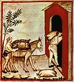 Dere Street continued in use between Durham and York in medieval times. Being limited by daylight, "about thirty miles in a day in winter on horseback and between thirty-six and forty in summer was what a man could do." Tough, vigorous men could walk from Darlington to York, and it was said that the quality of a horse could make the difference between a possible thirty and fifty miles per day. A wish to hear mass or the organisation of a train by the rich could shorten the travelling day to twenty miles. Roads were described as so muddy and difficult between November and February that in order to finish the journey by daylight one could barely stop to eat; however a "royal highway" or alta via regia strata was passable in winter between York and Durham, and this could have been Dere Street. Heavy packhorse loads were taken on the route, for example 20 stone of wool. Clerics, traders and the nobility were more likely to travel than others, and some people rarely travelled at all. Travelling in style involved the use of carts for luggage, but carts bogged down in winter mud, so traders with packhorses travelled more easily in winter than the rich.
Eboracum
Eboracum was a fort and city in Roman Britain. The settlement evolved into York, located in North Yorkshire, England.-Etymology:The first known recorded mention of Eboracum by name is dated circa 95-104 AD and is an address containing the Latin form of the settlement's name, "Eburaci", on a wooden...
(York) and Veluniate
Bo'ness
Bo'ness, properly Borrowstounness, is a coastal town in the Central Lowlands of Scotland. It lies on a hillside on the south bank of the Firth of Forth within the Falkirk council area, north-west of Edinburgh and east of Falkirk. At the 2001 census, Bo'ness had a resident population of 13,961...
, in what is now Scotland
Scotland
Scotland is a country that is part of the United Kingdom. Occupying the northern third of the island of Great Britain, it shares a border with England to the south and is bounded by the North Sea to the east, the Atlantic Ocean to the north and west, and the North Channel and Irish Sea to the...
. It still exists in the form of the route of many major roads, including the A1 and A68
A68 road
The A68 is a major road in the United Kingdom, running from Darlington in England to the A720 in Scotland.From Darlington, the road runs north, bypassing Bishop Auckland, and running through West Auckland, Toft Hill and Tow Law, past Consett and Corbridge...
just north of Corbridge
Coria (Corbridge)
Coria was a fort and town, located south of Hadrian's Wall, in the Roman province of Britannia. Its full Latin name is uncertain. Today it is known as Corchester or Corbridge Roman Site, adjoining Corbridge in the English county of Northumberland...
.
Its name corresponds with the post Roman Anglo-Saxon
Anglo-Saxons
Anglo-Saxon is a term used by historians to designate the Germanic tribes who invaded and settled the south and east of Great Britain beginning in the early 5th century AD, and the period from their creation of the English nation to the Norman conquest. The Anglo-Saxon Era denotes the period of...
kingdom of Deira
Deira
Deira was a kingdom in Northern England during the 6th century AD. Itextended from the Humber to the Tees, and from the sea to the western edge of the Vale of York...
, through which the first part of its route lies. It was sometimes referred to as "Watling Street" and marked on some maps as such. This can sometimes cause it to be confused with the Watling Street
Watling Street
Watling Street is the name given to an ancient trackway in England and Wales that was first used by the Britons mainly between the modern cities of Canterbury and St Albans. The Romans later paved the route, part of which is identified on the Antonine Itinerary as Iter III: "Item a Londinio ad...
that linked Dover
Dover
Dover is a town and major ferry port in the home county of Kent, in South East England. It faces France across the narrowest part of the English Channel, and lies south-east of Canterbury; east of Kent's administrative capital Maidstone; and north-east along the coastline from Dungeness and Hastings...
with Wroxeter
Wroxeter
Wroxeter is a village in Shropshire, England. It forms part of the civil parish of Wroxeter and Uppington and is located in the Severn Valley about south-east of Shrewsbury.-History:...
.
York to Catterick
The route began at York and crossed the River UreRiver Ure
The River Ure is a river in North Yorkshire, England, approximately long from its source to the point where it changes name to the River Ouse. It is the principal river of Wensleydale, which is the only one of the Dales now named after a village rather than its river...
near Isurium Brigantum
Isurium Brigantum
Isurium Brigantum was a town in the Roman province of Britannia. Today it is known as Aldborough, in North Yorkshire, England.-Possible Roman fort:...
(present-day Aldborough
Aldborough, North Yorkshire
Aldborough is a village in the civil parish of Boroughbridge, part of the Borough of Harrogate in North Yorkshire, England.Historically a part of the West Riding of Yorkshire, what is now known as Aldborough was built on the site of a major Romano-British town, Isurium Brigantum...
close to Boroughbridge
Boroughbridge
Boroughbridge is a small town and civil parish in the Harrogate district of North Yorkshire, England. It is situated northwest of York. Until its bypass was built, it was on the main A1 road from London to Edinburgh...
). From there, it crossed the River Swale
River Swale
The River Swale is a river in Yorkshire, England and a major tributary of the River Ure, which itself becomes the River Ouse, emptying into the North Sea via the Humber Estuary....
near Catterick, North Yorkshire
Catterick, North Yorkshire
Catterick , sometimes Catterick Village, to distinguish it from the nearby Catterick Garrison, is a village and civil parish in the Richmondshire district of North Yorkshire, England...
, where the Roman fort was called Cataractonium. (Just north of Catterick (at the modern Scotch Corner
Scotch Corner
Scotch Corner is an important junction of the A1 and A66 trunk roads near Richmond, North Yorkshire, England. It has been described as "the modern gateway to Cumbria, the North East and Scotland".-Geography:...
) the road over Stainmore
A66 road
The A66 is a major road in northern England which in part follows the course of the Roman road from Scotch Corner to Penrith. It runs from east of Middlesbrough in the ceremonial county of North Yorkshire to Workington in Cumbria...
to Penrith
Penrith, Cumbria
Penrith was an urban district between 1894 and 1974, when it was merged into Eden District.The authority's area was coterminous with the civil parish of Penrith although when the council was abolished Penrith became an unparished area....
, Carlisle and the Western end of Hadrian's Wall branched off).
River Tees crossing
Dere Street went on to cross the River TeesRiver Tees
The River Tees is in Northern England. It rises on the eastern slope of Cross Fell in the North Pennines, and flows eastwards for 85 miles to reach the North Sea between Hartlepool and Redcar.-Geography:...
near the Roman fort of Piercebridge
Piercebridge Roman Fort
Piercebridge Roman Fort is a scheduled ancient monument situated in the village of Piercebridge on the banks of the River Tees in County Durham, England. There were Romans here from about 70 AD until at least the early 5th century...
by a stone arch bridge: These are relatively rare in Roman Britain, except for Hadrian's Wall and Dere Street. The original bridge at Piercebridge was replaced by another on a different alignment, and there is some evidence for other minor realignments of Dere Street over the Roman period. Raymond Selkirk has suggested that the supposed remains of a Roman
Ancient Rome
Ancient Rome was a thriving civilization that grew on the Italian Peninsula as early as the 8th century BC. Located along the Mediterranean Sea and centered on the city of Rome, it expanded to one of the largest empires in the ancient world....
stone bridge on the south side of the Tees
River Tees
The River Tees is in Northern England. It rises on the eastern slope of Cross Fell in the North Pennines, and flows eastwards for 85 miles to reach the North Sea between Hartlepool and Redcar.-Geography:...
at Cliffe are remains of a jetty, and Time Team
Time Team
Time Team is a British television series which has been aired on Channel 4 since 1994. Created by television producer Tim Taylor and presented by actor Tony Robinson, each episode features a team of specialists carrying out an archaeological dig over a period of three days, with Robinson explaining...
investigated this in 2009. In 1994, a section through Dere Street was exposed by excavations carried out in a garage development area at Cliffe, and some pottery and tile found.
Bishop Auckland to the Cheviot Hills
The next river crossing was of the River WearRiver Wear
The River Wear is located in North East England, rising in the Pennines and flowing eastwards, mostly through County Durham, to the North Sea at Sunderland.-Geology and history:...
at the Roman fort of Vinovia, near present-day Bishop Auckland
Bishop Auckland
Bishop Auckland is a market town and civil parish in County Durham in north east England. It is located about northwest of Darlington and southwest of Durham at the confluence of the River Wear with its tributary the River Gaunless...
. At this point another road branched away to the right, heading for Durham
Durham
Durham is a city in north east England. It is within the County Durham local government district, and is the county town of the larger ceremonial county...
, Chester-le-Street
Chester-le-Street
Chester-le-Street is a town in County Durham, England. It has a history going back to Roman times when it was called Concangis. The town is located south of Newcastle upon Tyne and west of Sunderland on the River Wear...
and eventually crossing the Tyne at Pons Aelius
Pons Aelius
Pons Aelius or Newcastle Roman Fort was an auxiliary castra and small Roman settlement on Hadrian's Wall in the Roman province of Britannia Inferior...
the modern Newcastle
Newcastle upon Tyne
Newcastle upon Tyne is a city and metropolitan borough of Tyne and Wear, in North East England. Historically a part of Northumberland, it is situated on the north bank of the River Tyne...
.
From Vinovia, Dere Street travelled onwards past the Roman forts of Longovicium
Longovicium
Longovicium was an auxiliary fort on Dere Street, in the Roman province of Britannia Inferior. It is located just southwest of Lanchester in the English county of Durham, roughly to the west of the city of Durham and from Consett.-History:Longovicium was situated between the forts of...
(present-day Lanchester
Lanchester, County Durham
Lanchester is a village and civil parish in County Durham, England, and was in the former district of Derwentside . It is to the west of the city of Durham and from the former steel town of Consett, and has a population of slightly over 4,000 people.Although there was a small drift mine on the...
) and Vindomora
Vindomora
Vindomora was an auxiliary castra on Dere Street, in the Roman province of Britannia Inferior...
(present-day Ebchester
Ebchester
Ebchester is a village in County Durham, in England. It is situated to the north of Consett and to the south east of Whittonstall.The parish church, which is dedicated to St. Ebba is of ambiguous origin, being of partly Norman construction with a foundation, described as being pre-Conquest...
), before crossing the River Tyne
River Tyne
The River Tyne is a river in North East England in Great Britain. It is formed by the confluence of two rivers: the North Tyne and the South Tyne. These two rivers converge at Warden Rock near Hexham in Northumberland at a place dubbed 'The Meeting of the Waters'.The North Tyne rises on the...
near the fort of Coria (Corbridge)
Coria (Corbridge)
Coria was a fort and town, located south of Hadrian's Wall, in the Roman province of Britannia. Its full Latin name is uncertain. Today it is known as Corchester or Corbridge Roman Site, adjoining Corbridge in the English county of Northumberland...
, where it crossed Stanegate
Stanegate
The Stanegate, or "stone road" , was an important Roman road built in what is now northern England. It linked two forts that guarded important river crossings; Corstopitum in the east, situated on Dere Street, and Luguvalium in the west...
. Just North of Corbridge, the route passed through the fortifications of Hadrian's Wall
Hadrian's Wall
Hadrian's Wall was a defensive fortification in Roman Britain. Begun in AD 122, during the rule of emperor Hadrian, it was the first of two fortifications built across Great Britain, the second being the Antonine Wall, lesser known of the two because its physical remains are less evident today.The...
, at a point now known as Portgate, and passed into lands that were only tenuously under Roman domination.
From the Wall, the route continued north into Redesdale
Redesdale
Redesdale is a valley iin the western part of the county of Northumberland, in northeast England. This area contains the valley of the River Rede, a tributary of the North Tyne River. Redesdale includes the settlements of Elsdon, Otterburn, Rochester, Byrness and Carter Bar.Historically this...
and thence to the Cheviot Hills
Cheviot Hills
The Cheviot Hills is a range of rolling hills straddling the England–Scotland border between Northumberland and the Scottish Borders.There is a broad split between the northern and the southern Cheviots...
, where there are the remains of marching forts at Fourlaws, Habitancum
Habitancum
Habitancum was an ancient Roman fort located at Risingham, Northumberland, England. The fort was one of the defensive structures built along Dere Street, a Roman road running from York to Corbridge and onwards to Melrose....
(West Woodburn
West Woodburn
West Woodburn is a village in north-western Northumberland, England.The 2001 census recorded a population of 492 in the Parish Council area of Corsenside of which West Woodburn is the main settlement....
), Bremenium
Bremenium
Bremenium was an ancient Roman fort located at Rochester, Northumberland, England. The fort was one of the defensive structures built along Dere Street, a Roman road running from York to Corbridge and onwards to Melrose....
(Rochester
Rochester, Northumberland
Rochester is a small village and civil parish in north Northumberland, England. It is five miles north-east of Otterburn on the A68 road between Corbridge and Jedburgh...
), and at Chew Green
Chew Green
Chew Green is the site of the ancient Roman encampment Ad Fines in Northumberland, England, north of Rochester and west of Alwinton. The encampment was adjacent to Dere Street, a Roman road that stretched south to York , and almost on the present-day border with Scotland.Archaeological excavation...
.
In Scotland
Crossing the present day Scottish borderAnglo-Scottish border
The Anglo-Scottish border is the official border and mark of entry between Scotland and England. It runs for 154 km between the River Tweed on the east coast and the Solway Firth in the west. It is Scotland's only land border...
near the present A68 at Carter Fell
Carter Bar
The Carter Bar is the point at which the A68 crosses the England-Scotland border and forms a pass located at the top of Redesdale in the Cheviot Hills at an altitude of . The first sizeable Scottish town is Jedburgh approximately north. Other nearby Scottish towns include Hawick away and Kelso...
, there are the remains of a camp at Pennymuir
Pennymuir
The Pennymuir Roman camps are situated southeast of Jedburgh in the Scottish Borders area of Scotland, near the Anglo-Scottish border, in the former Roxburghshire. The site, alongside the course of the Roman road known as Dere Street, consists of the remains of three Roman temporary camps, a linear...
and well preserved sections of the road as it also forms part of St. Cuthbert's Way
St. Cuthbert's Way
St Cuthbert's Way is a long-distance trail between the Scottish Borders town of Melrose and Lindisfarne off the coast of Northumberland, England.It is part of the European walking route E2....
to Trimontium near Melrose
Melrose, Scotland
Melrose is a small town and civil parish in the Scottish Borders, historically in Roxburghshire. It is in the Eildon committee area.-Etymology:...
. Crossing the River Tweed
River Tweed
The River Tweed, or Tweed Water, is long and flows primarily through the Borders region of Great Britain. It rises on Tweedsmuir at Tweed's Well near where the Clyde, draining northwest, and the Annan draining south also rise. "Annan, Tweed and Clyde rise oot the ae hillside" as the Border saying...
at Trimontium the route follows the Leader Water to the foot of the Lammermuirs, where there is evidence of forts near Oxton
Oxton, Scottish Borders
Oxton is a rural village in the Scottish Borders area of Scotland, just off the A68. The small town of Lauder is 4.5 miles to the south, Edinburgh city centreis about 23 miles to the north. Other towns include Dalkeith ....
and another well preserved section of road rises through the Lammermuirs over Soutra
Soutra Aisle
Soutra Aisle, just within the Scottish Borders, not far from Fala, is the remains of the House of the Holy Trinity, a church that was part of a complex comprising a hospital and a friary...
hill, and then on to British
Britons (historical)
The Britons were the Celtic people culturally dominating Great Britain from the Iron Age through the Early Middle Ages. They spoke the Insular Celtic language known as British or Brythonic...
Din Eidyn
Edinburgh
Edinburgh is the capital city of Scotland, the second largest city in Scotland, and the eighth most populous in the United Kingdom. The City of Edinburgh Council governs one of Scotland's 32 local government council areas. The council area includes urban Edinburgh and a rural area...
, a stronghold of the Votadini
Votadini
The Votadini were a people of the Iron Age in Great Britain, and their territory was briefly part of the Roman province Britannia...
tribe, and where the Romans held strategic garrisons at Cramond
Cramond
Cramond is a seaside village now part of suburban Edinburgh, Scotland, located in the north-west corner of the city at the mouth of the River Almond where it enters the Firth of Forth....
and at Inveresk
Inveresk
Inveresk is a civil parish and was formerly a village that now forms the southern part of Musselburgh. It is situated on slightly elevated ground at the south of Musselburgh in East Lothian, Scotland...
to access the eastern end of the Antonine Wall
Antonine Wall
The Antonine Wall is a stone and turf fortification built by the Romans across what is now the Central Belt of Scotland, between the Firth of Forth and the Firth of Clyde. Representing the northernmost frontier barrier of the Roman Empire, it spanned approximately 39 miles and was about ten feet ...
.
After the Romans
In the High Middle AgesHigh Middle Ages
The High Middle Ages was the period of European history around the 11th, 12th, and 13th centuries . The High Middle Ages were preceded by the Early Middle Ages and followed by the Late Middle Ages, which by convention end around 1500....
, the section of the route between Jedburgh
Jedburgh
Jedburgh is a town and former royal burgh in the Scottish Borders and historically in Roxburghshire.-Location:Jedburgh lies on the Jed Water, a tributary of the River Teviot, it is only ten miles from the border with England and is dominated by the substantial ruins of Jedburgh Abbey...
and Edinburgh was known as the Via Regia or royal way, it connected the larger part of Scotland with the important ecclesiastic sites of the Scottish Borders. King Malcolm IV
Malcolm IV of Scotland
Malcolm IV , nicknamed Virgo, "the Maiden" , King of Scots, was the eldest son of Earl Henry and Ada de Warenne...
established his Church and Hospital of the Holy Trinity
Soutra Aisle
Soutra Aisle, just within the Scottish Borders, not far from Fala, is the remains of the House of the Holy Trinity, a church that was part of a complex comprising a hospital and a friary...
half way along this section to provide succour for the many pilgrims using it.
After the destruction of the Border Abbeys during "The Rough Wooing
The Rough Wooing
The War of the Rough Wooing was fought between Scotland and England. War was declared by Henry VIII of England, in an attempt to force the Scots to agree to a marriage between his son Edward and Mary, Queen of Scots. Scotland benefited from French military aid. Edward VI continued the war until...
" by the Earl of Hertford's forces of Mary, Queen of Scots, and the Reformation
Scottish Reformation
The Scottish Reformation was Scotland's formal break with the Papacy in 1560, and the events surrounding this. It was part of the wider European Protestant Reformation; and in Scotland's case culminated ecclesiastically in the re-establishment of the church along Reformed lines, and politically in...
of the Scottish Church
Church of Scotland
The Church of Scotland, known informally by its Scots language name, the Kirk, is a Presbyterian church, decisively shaped by the Scottish Reformation....
, the route fell into disuse and disrepair; and it was used mainly for driving livestock, and the occasional travellers daring enough to venture into the lawless border region.
Medieval travel on Dere Street
Further reading
- The Roads of Mediaeval LauderdaleLauderdaleLauderdale, denoting "dale of the river Leader", is the dale and region around that river in south-eastern Scotland.It can also refer to:-People:*Earls of Lauderdale*Lord Lauderdale, member of The Cabal of Charles II of England-Place names:Australia...
, by R. P. Hardie, Edinburgh & London, 1942.