
Bannaventa
Encyclopedia
Bannaventa was a Romano
British Fortified Town which was situated on the Roman road
of Watling Street
, which today is known as the A5 trunk road. Bannaventa is 1 miles northeast of the village of Norton
in the English
county of Northamptonshire
. The Ordnance Survey
grid reference for the centre of the town is SP612645.
) in the county of Kent
and runs in a north westerly direction linking many Roman settlements and towns along its route. At Viroconium (now Wroxeter
in Shropshire
), the road branched with one route going to Deva Victrix
(now Chester
) and the other into Wales
. Bannaventa was a small fortified town on this road and was 10.9 miles north west of the Roman town of Lactodorum (now Towcester
).17.3 miles to the north west was the Roman settlement of Venonis (now Wigston Parva
) where Watling street is intersected by the Fosse Way.
The extracts are as follows:
The translation of these place names are as follows although Isannavantia is assumed to be Bannaventa.
of a later period along Watling street. The town would have been a vital part of the road infrastructure
of Roman Britain
. The Fortified town would provide a safe, warm resting place where provisions for the journey could be purchased and horse
s and other livestock
could be safely stable
d overnight. The town would also provide some protection for the wider population in the vicinity in times of danger. In close proximity of the town there are several other Roman sites which are connected with Bannaventa. These include the remains of a villa
on the summit of near-by Borough Hill
, another smaller settlement between Thrupp lodge and Thrupp Grounds (SP 599651) and various other small homestead
s have been located at grid references SP613638, SP608649 and another Roman villa
at SP605649.
, Daventry
-Borough Hill
and even Northampton
had been suggested. There have been many archaeological finds across the site including the discovery of a skeleton and numerous cremations in a Roman burial ground a little south of the boundary of the fortifications. Other discoveries include Constantinian coins, some foundations, stonework, and pottery; most were found in the early 18th century and they led to the definitive location of the town. More finds in the 20th century have been discovered and are listed below:
.jpg)
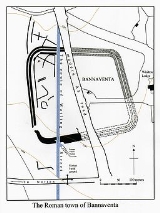
In 1970 the site was photographed from the air. This revealed the position of Roman Watling Street as it bisected the town, and the outline of the town lying to the west of the A5. The settlement was enclosed by an irregular quadrilateral shape with broad rounded corners, bounded by a series of three sets of banks and ditches. The enclosed area covered some 13.5 acres (55,000 m²). Inside the enclosure evidence has been found of the wooden buildings which made up most of the town. Nothing obviously Roman now remains above ground.
, patron saint of Ireland
. In his Confessio he said that he had been born in a settlement called Banavem Taburniae which could possibly be an alternative name for Bannaventa. He tells us that "... about sixteen years of age (around 405 AD) ... I was taken into captivity in Ireland", where he was held as a slave
. Watling Street ran ultimately to North Wales
(about 160 km to Chester, the nearest point of navigation on the Irish Sea), which offers easy passage to Ireland. After six years of slavery Saint Patrick escaped to Gaul
(now France
) where he became a monk, later returning to Ireland as a missionary
. His Confessio begins:
Roman Britain
Roman Britain was the part of the island of Great Britain controlled by the Roman Empire from AD 43 until ca. AD 410.The Romans referred to the imperial province as Britannia, which eventually comprised all of the island of Great Britain south of the fluid frontier with Caledonia...
British Fortified Town which was situated on the Roman road
Roman road
The Roman roads were a vital part of the development of the Roman state, from about 500 BC through the expansion during the Roman Republic and the Roman Empire. Roman roads enabled the Romans to move armies and trade goods and to communicate. The Roman road system spanned more than 400,000 km...
of Watling Street
Watling Street
Watling Street is the name given to an ancient trackway in England and Wales that was first used by the Britons mainly between the modern cities of Canterbury and St Albans. The Romans later paved the route, part of which is identified on the Antonine Itinerary as Iter III: "Item a Londinio ad...
, which today is known as the A5 trunk road. Bannaventa is 1 miles northeast of the village of Norton
Norton, Northamptonshire
Norton is a village in the district of Daventry in the English County of Northamptonshire. The village is about east of Daventry, west of Northampton. Junction 16 of the M1 motorway is about south-east and the nearest railway station is at Long Buckby to the east...
in the English
England
England is a country that is part of the United Kingdom. It shares land borders with Scotland to the north and Wales to the west; the Irish Sea is to the north west, the Celtic Sea to the south west, with the North Sea to the east and the English Channel to the south separating it from continental...
county of Northamptonshire
Northamptonshire
Northamptonshire is a landlocked county in the English East Midlands, with a population of 629,676 as at the 2001 census. It has boundaries with the ceremonial counties of Warwickshire to the west, Leicestershire and Rutland to the north, Cambridgeshire to the east, Bedfordshire to the south-east,...
. The Ordnance Survey
Ordnance Survey
Ordnance Survey , an executive agency and non-ministerial government department of the Government of the United Kingdom, is the national mapping agency for Great Britain, producing maps of Great Britain , and one of the world's largest producers of maps.The name reflects its creation together with...
grid reference for the centre of the town is SP612645.
Iter II (Watling Street)
The road where Bannaventa was located is thought to be the first road constructed by the Romans in Britain. It begins in Portus Ritupis (now RichboroughRichborough
Richborough is a settlement north of Sandwich on the east coast of the county of Kent, England. Richborough lies close to the Isle of Thanet....
) in the county of Kent
Kent
Kent is a county in southeast England, and is one of the home counties. It borders East Sussex, Surrey and Greater London and has a defined boundary with Essex in the middle of the Thames Estuary. The ceremonial county boundaries of Kent include the shire county of Kent and the unitary borough of...
and runs in a north westerly direction linking many Roman settlements and towns along its route. At Viroconium (now Wroxeter
Wroxeter
Wroxeter is a village in Shropshire, England. It forms part of the civil parish of Wroxeter and Uppington and is located in the Severn Valley about south-east of Shrewsbury.-History:...
in Shropshire
Shropshire
Shropshire is a county in the West Midlands region of England. For Eurostat purposes, the county is a NUTS 3 region and is one of four counties or unitary districts that comprise the "Shropshire and Staffordshire" NUTS 2 region. It borders Wales to the west...
), the road branched with one route going to Deva Victrix
Deva Victrix
Deva Victrix, or simply Deva, was a legionary fortress and town in the Roman province of Britannia. The settlement evolved into Chester, the county town of Cheshire, England...
(now Chester
Chester
Chester is a city in Cheshire, England. Lying on the River Dee, close to the border with Wales, it is home to 77,040 inhabitants, and is the largest and most populous settlement of the wider unitary authority area of Cheshire West and Chester, which had a population of 328,100 according to the...
) and the other into Wales
Wales
Wales is a country that is part of the United Kingdom and the island of Great Britain, bordered by England to its east and the Atlantic Ocean and Irish Sea to its west. It has a population of three million, and a total area of 20,779 km²...
. Bannaventa was a small fortified town on this road and was 10.9 miles north west of the Roman town of Lactodorum (now Towcester
Towcester
Towcester , the Roman town of Lactodorum, is a small town in south Northamptonshire, England.-Etymology:Towcester comes from the Old English Tófe-ceaster. Tófe refers to the River Tove; Bosworth and Toller compare it to the "Scandinavian proper names" Tófi and Tófa...
).17.3 miles to the north west was the Roman settlement of Venonis (now Wigston Parva
Wigston Parva
Wigston Parva is a hamlet and civil parish in the Blaby district of Leicestershire, England. The parish has a population of about 30. It is very near the county boundary with Warwickshire. Nearby places include Smockington, and Sharnford.-External links:...
) where Watling street is intersected by the Fosse Way.
Name
The meaning of the name Bannaventa is from “The Market on the spur of the Land”. mention of the settlement can be found in Emperor Antoninus Pius’s Itinerarium, Iter Britanniarum (The Road Routes of Antoninus Augustus).The extracts are as follows:
- Iter 2, Venone XII, Benaventa XVII, Lactodorum XII.
- Iter 6, Lactodorum XVI, Isannavaria XII, Tripontium XII.
- Iter 8, Venone XII, Benaventa XVIII, Magiovinter XXVIII.
The translation of these place names are as follows although Isannavantia is assumed to be Bannaventa.
- Venone = High Cross, Wigston ParvaWigston ParvaWigston Parva is a hamlet and civil parish in the Blaby district of Leicestershire, England. The parish has a population of about 30. It is very near the county boundary with Warwickshire. Nearby places include Smockington, and Sharnford.-External links:...
, LeicestershireLeicestershireLeicestershire is a landlocked county in the English Midlands. It takes its name from the heavily populated City of Leicester, traditionally its administrative centre, although the City of Leicester unitary authority is today administered separately from the rest of Leicestershire... - Isannavantia = Bannaventa
- TripontiumTripontiumTripontium was a town in Roman Britain. It lay on the Roman road later called Watling Street at a site now chiefly within the civil parish of Newton and Biggin in the English county of Warwickshire and partly in Leicestershire, some 3.4 miles north-east of Rugby and 3.1 miles south of...
= Cave's Inn, WarwickshireWarwickshireWarwickshire is a landlocked non-metropolitan county in the West Midlands region of England. The county town is Warwick, although the largest town is Nuneaton. The county is famous for being the birthplace of William Shakespeare... - Magiovinter = Dropshort, BuckinghamshireBuckinghamshireBuckinghamshire is a ceremonial and non-metropolitan home county in South East England. The county town is Aylesbury, the largest town in the ceremonial county is Milton Keynes and largest town in the non-metropolitan county is High Wycombe....
Description
Bannaventa was a posting station for Roman travelers and would have operated along the lines of the Coaching townsCoaching inn
In Europe, from approximately the mid-17th century for a period of about 200 years, the coaching inn, sometimes called a coaching house or staging inn, was a vital part of the inland transport infrastructure, as an inn serving coach travelers...
of a later period along Watling street. The town would have been a vital part of the road infrastructure
Infrastructure
Infrastructure is basic physical and organizational structures needed for the operation of a society or enterprise, or the services and facilities necessary for an economy to function...
of Roman Britain
Roman Britain
Roman Britain was the part of the island of Great Britain controlled by the Roman Empire from AD 43 until ca. AD 410.The Romans referred to the imperial province as Britannia, which eventually comprised all of the island of Great Britain south of the fluid frontier with Caledonia...
. The Fortified town would provide a safe, warm resting place where provisions for the journey could be purchased and horse
Horse
The horse is one of two extant subspecies of Equus ferus, or the wild horse. It is a single-hooved mammal belonging to the taxonomic family Equidae. The horse has evolved over the past 45 to 55 million years from a small multi-toed creature into the large, single-toed animal of today...
s and other livestock
Livestock
Livestock refers to one or more domesticated animals raised in an agricultural setting to produce commodities such as food, fiber and labor. The term "livestock" as used in this article does not include poultry or farmed fish; however the inclusion of these, especially poultry, within the meaning...
could be safely stable
Stable
A stable is a building in which livestock, especially horses, are kept. It most commonly means a building that is divided into separate stalls for individual animals...
d overnight. The town would also provide some protection for the wider population in the vicinity in times of danger. In close proximity of the town there are several other Roman sites which are connected with Bannaventa. These include the remains of a villa
Borough Hill Roman villa
Borough Hill Roman villa is located on the north tip of Borough Hill, a prominent hill near the town of Daventry in Northamptonshire. The villa’s remains lie within the ramparts of an Iron Age fortress which covers the summit of the hill...
on the summit of near-by Borough Hill
Borough Hill
Borough Hill is a hill to the east of the town of Daventry in the English county of Northamptonshire. It is over above sea level and dominates the surrounding area.-Archaeology:...
, another smaller settlement between Thrupp lodge and Thrupp Grounds (SP 599651) and various other small homestead
Homestead (buildings)
A homestead is either a single building, or collection of buildings grouped together on a large agricultural holding, such as a ranch, station or a large agricultural operation of some other designation.-See also:* Farm house* Homestead Act...
s have been located at grid references SP613638, SP608649 and another Roman villa
Roman villa
A Roman villa is a villa that was built or lived in during the Roman republic and the Roman Empire. A villa was originally a Roman country house built for the upper class...
at SP605649.
Rediscovery
It was not until the early 18th century that the site of Bannaventa was positively identified. Previously, sites at near-by Weedon BecWeedon Bec
Weedon Bec , usually just called "Weedon", is a large village and parish in the district of Daventry, Northamptonshire, England. It lies close to the source of the River Nene.-Geography:...
, Daventry
Daventry
Daventry is a market town in Northamptonshire, England, with a population of 22,367 .-Geography:The town is also the administrative centre of the larger Daventry district, which has a population of 71,838. The town is 77 miles north-northwest of London, 13.9 miles west of Northampton and 10.2...
-Borough Hill
Borough Hill
Borough Hill is a hill to the east of the town of Daventry in the English county of Northamptonshire. It is over above sea level and dominates the surrounding area.-Archaeology:...
and even Northampton
Northampton
Northampton is a large market town and local government district in the East Midlands region of England. Situated about north-west of London and around south-east of Birmingham, Northampton lies on the River Nene and is the county town of Northamptonshire. The demonym of Northampton is...
had been suggested. There have been many archaeological finds across the site including the discovery of a skeleton and numerous cremations in a Roman burial ground a little south of the boundary of the fortifications. Other discoveries include Constantinian coins, some foundations, stonework, and pottery; most were found in the early 18th century and they led to the definitive location of the town. More finds in the 20th century have been discovered and are listed below:
- A number of rubbish pits dating from the 1st and 2nd century
- In 1900, Roman coins of VictorinusVictorinusMarcus Piavonius Victorinus was emperor of the secessionist Gallic Empire from 269 to 271, following the brief reign of Marius. He was murdered by a jealous husband whose wife he tried to seduce.-Reign:...
and Samian ware, remnants of buildings including wall plaster, rotten wood, roof slates, and a cobbled floor. - In 1922 roman coinsRoman currencyThe Roman currency during most of the Roman Republic and the western half of the Roman Empire consisted of coins including the aureus , the denarius , the sestertius , the dupondius , and the as...
including a SestertiusSestertiusThe sestertius, or sesterce, was an ancient Roman coin. During the Roman Republic it was a small, silver coin issued only on rare occasions...
of HadrianHadrianHadrian , was Roman Emperor from 117 to 138. He is best known for building Hadrian's Wall, which marked the northern limit of Roman Britain. In Rome, he re-built the Pantheon and constructed the Temple of Venus and Roma. In addition to being emperor, Hadrian was a humanist and was philhellene in...
. - In 1957 a Large Nene Valley beaker, large painted pot, part of a glass bowl. Fragments of a black Samian pot plus many other artifacts.
In 1970 the site was photographed from the air. This revealed the position of Roman Watling Street as it bisected the town, and the outline of the town lying to the west of the A5. The settlement was enclosed by an irregular quadrilateral shape with broad rounded corners, bounded by a series of three sets of banks and ditches. The enclosed area covered some 13.5 acres (55,000 m²). Inside the enclosure evidence has been found of the wooden buildings which made up most of the town. Nothing obviously Roman now remains above ground.
Saint Patrick connection
It is possible that Bannaventa was the birthplace of Saint PatrickSaint Patrick
Saint Patrick was a Romano-Briton and Christian missionary, who is the most generally recognized patron saint of Ireland or the Apostle of Ireland, although Brigid of Kildare and Colmcille are also formally patron saints....
, patron saint of Ireland
Ireland
Ireland is an island to the northwest of continental Europe. It is the third-largest island in Europe and the twentieth-largest island on Earth...
. In his Confessio he said that he had been born in a settlement called Banavem Taburniae which could possibly be an alternative name for Bannaventa. He tells us that "... about sixteen years of age (around 405 AD) ... I was taken into captivity in Ireland", where he was held as a slave
Slavery
Slavery is a system under which people are treated as property to be bought and sold, and are forced to work. Slaves can be held against their will from the time of their capture, purchase or birth, and deprived of the right to leave, to refuse to work, or to demand compensation...
. Watling Street ran ultimately to North Wales
North Wales
North Wales is the northernmost unofficial region of Wales. It is bordered to the south by the counties of Ceredigion and Powys in Mid Wales and to the east by the counties of Shropshire in the West Midlands and Cheshire in North West England...
(about 160 km to Chester, the nearest point of navigation on the Irish Sea), which offers easy passage to Ireland. After six years of slavery Saint Patrick escaped to Gaul
Gaul
Gaul was a region of Western Europe during the Iron Age and Roman era, encompassing present day France, Luxembourg and Belgium, most of Switzerland, the western part of Northern Italy, as well as the parts of the Netherlands and Germany on the left bank of the Rhine. The Gauls were the speakers of...
(now France
France
The French Republic , The French Republic , The French Republic , (commonly known as France , is a unitary semi-presidential republic in Western Europe with several overseas territories and islands located on other continents and in the Indian, Pacific, and Atlantic oceans. Metropolitan France...
) where he became a monk, later returning to Ireland as a missionary
Missionary
A missionary is a member of a religious group sent into an area to do evangelism or ministries of service, such as education, literacy, social justice, health care and economic development. The word "mission" originates from 1598 when the Jesuits sent members abroad, derived from the Latin...
. His Confessio begins:
External links
- Roman-Britain.org - info about Bannaventa