
Rutupiae
Encyclopedia
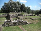
Richborough Castle contains the ruined remains of a Roman Saxon Shore Fort. It situated in Richborough
near Sandwich, Kent
.
The site has many phases of Roman remains, collectively known as Richborough Fort or Richborough Roman Fort, still visible today and under the care of English Heritage
.
Rutupiæ (its Latin name) was founded by Romans when they landed in England
in AD 43. It was a major port of Roman Britain
(with Dubris
, it was one of the start-points for the Roman road of Watling Street
, which ran on to Canterbury
and London
).
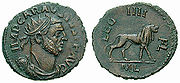
Earth fortifications were first dug on the site in the 1st century, probably was as a storage depot and bridgehead for the Roman army. This transformed into a civilian and commercial town, which was later replaced by a Saxon Shore Fort around the year 277. The later fort is believed to have been constructed by Carausius.
.
As a port, the town always competed with Portus Dubris (modern Dover
), about 15 miles (25 km) south along the coast. However, Richborough was widely regarded throughout the Roman Empire for the quality of its oysters (they are mentioned as on a par with those from the Italian Lucrine Lake in Juvenal
, Satires 4.141), whilst "Rutupine shore" was used as a synonym for the whole coast of Britain in some literary works.
triumphal arch
was erected straddling Watling Street, the main road from Richborough to London. Its position and size suggest it may have been built to celebrate the final conquest of Britain after Agricola’s victory at Mons Graupius.
Almost 25 metres high, it had a facade of high quality, Italian granite. Standing as it did between the port and the province, passage through the arch signified formal entry into Britannia
(cf the similarly maritime arch at Ancona
). Only its foundations and mound are still visible.
.jpg)
 During the late 3rd century this (by now large) civilian town was remilitarized by its conversion into a Saxon Shore Fort. The Saxon Shore Forts were a series of forts built by the Romans along the Channel on the English and French sides, to guard against invading Saxon pirates. Construction of the fort here is believed to have started in 277 and completed in 285. This involved the demolition and reuse as spolia
of the triumphal arch, and numismatic evidence suggests it occurred during the reign of Carausius
.
The fort was 5 acres (2 ha) in area and was surrounded by massive walls, forming an almost perfect square. However, the construction of the north and south walls differed. The north wall was built by different gangs of laborers, while the south wall seems to have been built as a single unit. This suggests that the north wall of the fort was built sometime after the construction of the south wall. In some places, the walls reached over 25 feet (8 m) in height, and were built of small ashlar and double-tile courses. The main entrance of the fort was in the west wall. The walls stand to a great height and were of such high quality, that they only recently needed repointing.
Though some stone buildings existed in the interior of the fort, most of its buildings seem to have been composed of timber. There existed a central rectangular building built of stone, which was probably the principia (headquarters). Small, stone built bathes were also present at Richborough.
Richborough
Richborough is a settlement north of Sandwich on the east coast of the county of Kent, England. Richborough lies close to the Isle of Thanet....
near Sandwich, Kent
Sandwich, Kent
Sandwich is a historic town and civil parish on the River Stour in the Non-metropolitan district of Dover, within the ceremonial county of Kent, south-east England. It has a population of 6,800....
.
The site has many phases of Roman remains, collectively known as Richborough Fort or Richborough Roman Fort, still visible today and under the care of English Heritage
English Heritage
English Heritage . is an executive non-departmental public body of the British Government sponsored by the Department for Culture, Media and Sport...
.
Rutupiæ (its Latin name) was founded by Romans when they landed in England
England
England is a country that is part of the United Kingdom. It shares land borders with Scotland to the north and Wales to the west; the Irish Sea is to the north west, the Celtic Sea to the south west, with the North Sea to the east and the English Channel to the south separating it from continental...
in AD 43. It was a major port of Roman Britain
Roman Britain
Roman Britain was the part of the island of Great Britain controlled by the Roman Empire from AD 43 until ca. AD 410.The Romans referred to the imperial province as Britannia, which eventually comprised all of the island of Great Britain south of the fluid frontier with Caledonia...
(with Dubris
Dubris
Dubris or Portus Dubris was a town in Roman Britain. It is now Dover, Kent, England.As the closest point to continental Europe and the site of the estuary of the Dour, the site chosen for Dover was ideal for a cross-channel port...
, it was one of the start-points for the Roman road of Watling Street
Watling Street
Watling Street is the name given to an ancient trackway in England and Wales that was first used by the Britons mainly between the modern cities of Canterbury and St Albans. The Romans later paved the route, part of which is identified on the Antonine Itinerary as Iter III: "Item a Londinio ad...
, which ran on to Canterbury
Canterbury
Canterbury is a historic English cathedral city, which lies at the heart of the City of Canterbury, a district of Kent in South East England. It lies on the River Stour....
and London
London
London is the capital city of :England and the :United Kingdom, the largest metropolitan area in the United Kingdom, and the largest urban zone in the European Union by most measures. Located on the River Thames, London has been a major settlement for two millennia, its history going back to its...
).
Earth fortifications were first dug on the site in the 1st century, probably was as a storage depot and bridgehead for the Roman army. This transformed into a civilian and commercial town, which was later replaced by a Saxon Shore Fort around the year 277. The later fort is believed to have been constructed by Carausius.
Invasion of 43 A.D.
It has commonly been accepted that Richborough was the landing site for the 43 AD invasion. This is because of the existence of mid-1st century AD ditches and fortifications on the site. These ditches and fortifications are assumed to have been built to protect their bridgehead and supply depot. However, the site of the Claudian invasion of Britain in the year 43 AD is not stated in the surviving written sources and has recently started to be debatedSite of the Claudian invasion of Britain
The site of the Claudian invasion of Britain in AD 43 is a matter of some controversy. Although it is generally believed that the force left from Gesoriacum , it is possible that part of the fleet sailed from near the mouth of the Rhine. And while Rutupiæ is often stated as the site of the landing...
.
Civilian town
As the fighting moved north, Rutupiae became an increasingly large civilian settlement. There were temples, an amphitheatre (visible as a hummock in the grass 5 minutes walk from the main site), and a Mansio (first built in 100, it was a building that went through several phases, being a hotel for visiting officials, bath house and administration building).As a port, the town always competed with Portus Dubris (modern Dover
Dover
Dover is a town and major ferry port in the home county of Kent, in South East England. It faces France across the narrowest part of the English Channel, and lies south-east of Canterbury; east of Kent's administrative capital Maidstone; and north-east along the coastline from Dungeness and Hastings...
), about 15 miles (25 km) south along the coast. However, Richborough was widely regarded throughout the Roman Empire for the quality of its oysters (they are mentioned as on a par with those from the Italian Lucrine Lake in Juvenal
Juvenal
The Satires are a collection of satirical poems by the Latin author Juvenal written in the late 1st and early 2nd centuries AD.Juvenal is credited with sixteen known poems divided among five books; all are in the Roman genre of satire, which, at its most basic in the time of the author, comprised a...
, Satires 4.141), whilst "Rutupine shore" was used as a synonym for the whole coast of Britain in some literary works.
Triumphal arch
A major quadrifronsQuadrifrons
Quadrifrons is a Latin word, meaning four-fronted or four-faced, particularly:*Form of triumphal arch with four arches and hence with barrel vaulted passageway in the form of a cross.*Aspect of Janus, god.Quadrifrons is believed to be the fourth face of...
triumphal arch
Triumphal arch
A triumphal arch is a monumental structure in the shape of an archway with one or more arched passageways, often designed to span a road. In its simplest form a triumphal arch consists of two massive piers connected by an arch, crowned with a flat entablature or attic on which a statue might be...
was erected straddling Watling Street, the main road from Richborough to London. Its position and size suggest it may have been built to celebrate the final conquest of Britain after Agricola’s victory at Mons Graupius.
Almost 25 metres high, it had a facade of high quality, Italian granite. Standing as it did between the port and the province, passage through the arch signified formal entry into Britannia
Britannia
Britannia is an ancient term for Great Britain, and also a female personification of the island. The name is Latin, and derives from the Greek form Prettanike or Brettaniai, which originally designated a collection of islands with individual names, including Albion or Great Britain. However, by the...
(cf the similarly maritime arch at Ancona
Ancona
Ancona is a city and a seaport in the Marche region, in central Italy, with a population of 101,909 . Ancona is the capital of the province of Ancona and of the region....
). Only its foundations and mound are still visible.
Saxon Shore Fort
Spolia
Spolia is a modern art-historical term used to describe the re-use of earlier building material or decorative sculpture on new monuments...
of the triumphal arch, and numismatic evidence suggests it occurred during the reign of Carausius
Carausius
Marcus Aurelius Mausaeus Valerius Carausius was a military commander of the Roman Empire in the 3rd century. He was a Menapian from Belgic Gaul, who usurped power in 286, declaring himself emperor in Britain and northern Gaul. He did this only 13 years after the Gallic Empire of the Batavian...
.
The fort was 5 acres (2 ha) in area and was surrounded by massive walls, forming an almost perfect square. However, the construction of the north and south walls differed. The north wall was built by different gangs of laborers, while the south wall seems to have been built as a single unit. This suggests that the north wall of the fort was built sometime after the construction of the south wall. In some places, the walls reached over 25 feet (8 m) in height, and were built of small ashlar and double-tile courses. The main entrance of the fort was in the west wall. The walls stand to a great height and were of such high quality, that they only recently needed repointing.
Though some stone buildings existed in the interior of the fort, most of its buildings seem to have been composed of timber. There existed a central rectangular building built of stone, which was probably the principia (headquarters). Small, stone built bathes were also present at Richborough.