

U.S. Route 80
Encyclopedia
U.S. Route 80 is an east–west United States highway, much of which was once part of the early auto trail
known as the Dixie Overland Highway. As the "0" in the route number indicates, it was originally a cross-country route, from the Atlantic
to the Pacific
. However, the entire segment west of Dallas, Texas
, has been decommissioned
in favor of various Interstate highways and state highways. Currently, the highway's eastern terminus is in Tybee Island
, Georgia
, at the Atlantic Ocean
. Its western terminus is at the border of Dallas and Mesquite
, Texas
, at an intersection with Interstate 30
.

, Texas
. With Spur 557, it serves as the shortest freeway route from the central and northern portions of Dallas to Interstate 20
, heading east towards Shreveport
, Louisiana
.
From its origin at Interstate 30
in eastern Dallas, through its interchange with the Interstate 635
"LBJ" Loop, to its junction with Interstate 20 southwest of Terrell
, US 80/Texas Spur 557 is a full interstate-grade limited-access freeway. (This freeway was originally built as Interstate 20 but was rerouted south of Dallas in 1971 and 1991.) In western Terrell, US 80 leaves the freeway, which continues southeast as (unsigned) Spur 557 to Interstate Highway 20, while US 80 runs north of Interstate 20 through a number of small towns and cities, including Terrell, Mineola, Longview, and Marshall. It rejoins Interstate Highway 20 for about five miles, before splitting from Interstate Highway 20 to pass through downtown Waskom
before crossing into Louisiana.
for the entirety of its length in Louisiana.
The highway crosses the state line from Texas into Caddo Parish as a two-lane road and crosses over to the south of I-20 without interchanging with the freeway. It passes through the town of Greenwood
where it meets US 79
coming north from Texas, and these two routes run concurrently eastward from there to Minden
. US 79/80 crosses over I-20 again, this time at an interchange, and enters the city of Shreveport as Greenwood Road. The highway passes over I-220 without an interchange and continues east to an intersection with Jefferson Paige Road where it expands to four undivided lanes and enters the main part of the urbanized area. US 171
ends at US 79/80 at the intersection with Hearne Avenue. At this intersection, the road narrows to two through lanes. US 80 intersects I-20 again just east of here. At Mansfield Road (old US 171), the highway name changes to Texas Avenue and angles northeast through an industrial area. The road skirts the I-20/49 interchange and expands to four lanes for its final approach to downtown. At the west edge of downtown, eastbound jogs one block east on Crockett Street and two blocks north on Common Street north to Texas Street; westbound jogs one block south from Texas Street down Common to Texas Avenue. US 79/80 passes through downtown Shreveport on Texas Street before crossing the Red River on the 1930s vintage Long-Allen Bridge and entering Bossier City
and Bossier Parish
.
Through Bossier Parish, US 79/80 comprises a major urban and suburban arterial (East Texas Street) carrying a minimum of four lanes. In the eastern reaches of the parish, and continuing into Webster Parish
, it is a divided highway. The road intersects the east end of I-220 at an interchange. US 79/80 stays to the north of I-20, except for a stretch east of Haughton
where it strays to the south for a period, skirting the north edge of the Louisiana Army Ammunition Plant
. At Dixie Inn, the highway intersects US 371. In Minden, US 79 separates from US 80 and continues its northeasterly trajectory toward Arkansas.
East of Minden, US 80 crosses to the south of I-20 and serves the Bienville Parish
towns of Gibsland
and Arcadia
. Entering Lincoln Parish, the highway serves Simsboro
and Grambling
before entering Ruston
(via West California Avenue) and multiplexing with US 167
on a north/south couplet of streets (Vienna Street/Trenton Street) through the business district. US 80 resumes its eastward path on the north side of Ruston and exits the city on East Georgia Avenue.
Between Ruston and Monroe the highway serves the small communities of Choudrant
and Calhoun
. Now on the north side of the interstate, it enters Ouachita Parish and approaches the Monroe area as a two-lane road. US 80 crosses LA 143 and enters West Monroe
on Cypress Street, where it continues south into the business district and widens to a four-lane urban arterial. At junction LA 34 (Bridge Street), US 80 makes a left turn, angling northeast, and crosses the Ouachita River, entering the city of Monroe. As Louisville Avenue it passes north of downtown, but the downtown area can be accessed via Business US 165 which intersects US 80 at North 5th/North 6th Street and becomes concurrent from there to the east. Louisville Avenue rapidly becomes a heavily commercialized urban arterial and remains so as it passes through the city, eventually curving southwestward and meeting the intersection with Desiard Street.
As Desiard Street, US 80 immediately meets mainline U.S. Route 165
, on its expressway bypass alignment, at a diamond interchange. Eastward from there, US 80 passes through suburban areas until it meets LA 139, where it is forced to turn off its four-lane alignment at an intersection which favors LA 139 traffic. Now a two-lane road, US 80 continues east through northeast Louisiana, passing through Richland
and Madison
parishes and serving the communities and towns of Start
, Rayville
(intersection with US 425), Delhi
(intersection with LA 17), Tallulah
(intersection with U.S. Route 65
), Mound
, and Delta
.
Just west of Delta, US 80 turns off its original route and runs a short distance south to an interchange with I-20. The original alignment of US 80 into Delta is now designated as LA 3218. The original US 80 Mississippi River Bridge remains active as a rail bridge but the roadway portion is closed to traffic. Today, US 80 runs concurrent with the interstate around Delta to the state line, bypassing the town and crossing the Mississippi River bridge into Vicksburg
, Mississippi
.
Highway 80 out of Louisiana runs concurrently with I-20
across the Mississippi River
to Vicksburg
. At Vicksburg, US 80 runs along Clay Street as a four-lane highway to its intersection with Interstate 20. It stays a two-lane road to Vicksburg. Heading out of Vicksburg, US 80 passes through the towns of Bolton
and Edwards
. After the town of Edwards on Norrell Road, US 80 merges with I-20 until it reaches the western edge of Clinton
. After Clinton, it passes through Jackson
, Flowood
, a four-lane through Pearl
, and a four-lane through Brandon
. After Brandon, US 80 runs parallel to I-20 for the next 100 miles through the towns of Pelahatchie
, Morton
, Forest
, Lake
, Newton
, Hickory
, and Chunky
. After Chunky, US 80 merges with I-20 to Meridian
where it becomes a two-lane highway heading to the town of Toombsuba and finally ending at the Alabama state line. US 80 is also merged with Highway 7 and 11 from Meridian to the Alabama state line.
in Cuba
. It is co-signed with US 11 until it splits at Cuba and runs east across the center of the state. It is a major highway through Alabama's Black Belt
, going through Demopolis
and Selma
. It continues to Montgomery
, where it continues east through Shorter
and Tuskegee
and leaves the state in Phenix City
.
The routing from Meridian, Mississippi to Cuba, Alabama originally ran along its current route but for some 30 years it traveled along Interstate 20
and Interstate 59
. However, the routing reverted to the original road early in the 2000 decade. It is internally designated by the Alabama Department of Transportation
as State Route 8 (SR-8).
 US 80 crosses the Chattahoochee River
from Alabama into Columbus
, where it proceeds along J. R. Allen Parkway through the northern section of the city. Past Columbus, the road meanders through rural Georgia for roughly 50 miles (80.5 km) en route to Macon
, where it crosses Interstate 75
and Interstate 16
. US 80 passes through downtown Macon via Eisenhower Parkway and parallels the northern boundary of Ocmulgee National Monument
just east of the city.
Beyond Macon, US 80 turns southeastward, passing through the cities of Dublin
, Swainsboro
and Statesboro
and running roughly parallel to I-16. On the outskirts of Savannah
, US-80 crosses Interstate 95
and follows Louisville Road into the city's downtown area. After briefly merging with Interstate 516
, US-80 continues eastward along Victory Drive, just south of Savannah's historic district. At the community of Thunderbolt, US 80 crosses the Wilmington River and proceeds across the islands and marshes along the Atlantic Coast east of Savannah. There it crosses the Lazaretto Creek
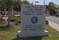
onto Tybee Island. The final stretch of US-80 follows Butler Avenue across Tybee Island. The highway terminates at 19th Street, a few hundred feet from the ocean. A small monument at the intersection of Butler and Tybrisa Street marks the end of the highway.
in American highway folklore, as several significant historical events have occurred on or near Highway 80. Bonnie and Clyde
were ambushed approximately four miles south of US 80 in Gibsland
, Louisiana
. Lee Harvey Oswald
was captured at the Texas Theatre on Jefferson Street in Oak Cliff
, which at the time was a business spur of Highway 80.
 US 80 originally had its western terminus in San Diego
, California
. It was decommissioned in 1964 when Interstate 8
through San Diego and Imperial Counties was completed. US 80 crossed into California after passing over the 1914 Ocean to Ocean Highway Bridge in Yuma, Arizona
. After passing through Winterhaven
, US 80 traveled through the Colorado Desert
and the Algodones Dunes
until it reached the former shoreline of prehistoric Lake Cahuilla
. The path through the dunes replaced the Old Plank Road
originally built in 1915. 80 then passed into the farmland of the Imperial Valley at Holtville
. US 80 traveled parallel to the Holton Interurban Railway into El Centro
. From this point to Ocotillo, the road has now been designated Imperial County Route S80, and carries the name Evan Hewes Highway. In El Centro, the original alignment went right through the middle of town on Main Street, but this was later bypassed in favor of a route along 4th Street and Adams Avenue. The old road then passed through Seeley
, the gypsum
plant at Plaster City
, and into Coyote Wells near present day Ocotillo
. From Coyote Wells, US 80 ascended the In-Ko-Pah Gorge to Jacumba
near the Mexican border. Old 1917 period concrete sections of highway can be seen in and around Jacumba. US 80 became a mountain highway as it entered the Jacumba
and Laguna Mountains
, and passed through the towns of Bankhead Springs, Boulevard
, Live Oak Springs, La Posta, Pine Valley
, Guatay
, and Descanso Junction. More old sections of roadway are found east of Boulevard, west of Guatay, and on the long Wildwood Glen section west of Descanso Junction. Old US 80 is cut by the Interstate here but resumes soon afterwards and passes through the Viejas Indian Reservation
. The highway traveled through Alpine
on more than one path, passed through Flinn Springs and along the main streets of El Cajon
, La Mesa
, and the former town of East San Diego. Once in San Diego, US 80 had multiple alignments into the downtown area. These included: University Ave to Hillcrest
and down 4th/5th Ave to Horton Plaza; a later alignment down Park Blvd to Broadway (US 101
); then El Cajon Blvd to Park Blvd and a terminus at Market Street (US 101); an extension to the new routing of US 101 on Harbor Blvd; a new connection from El Cajon Blvd along Washington Street to the Cabrillo Freeway (current State Route 163) and into downtown; and finally a routing down the Alvarado Freeway (current Interstate 8) to end at the US 101 freeway that is now Interstate 5
.
 Starts at the Colorado River
crossing on the Coast-to-Coast Highway bridge, near Yuma
. East of Yuma, the old route splits off Interstate 8
and parallels it to Gila Bend
, it then heads to the north, crossing the Gila River near Gillespie Dam
, and heads east through towns of Buckeye
, Goodyear
, and Avondale
before reaching the city of Phoenix
. The currently historic alignment is present day Buckeye Rd or MC 85. It heads north on 17th Ave to Van Buren St. After passing through downtown Phoenix, it then heads east on Van Buren to Tempe
, along Mill Ave to Apache Blvd. After passing through Tempe, Arizona, it continues heading east into Mesa
and Apache Junction
on Apache Trail. East of Apache Junction it travels on current U.S. Route 60
to Florence Junction. It turns south at the junction to Florence
and continues south to Oracle Jct, north of Tucson. This stretch coincides Interstate 10
, which it intersects in Tucson
. East of Tucson at Benson
, it cuts south and travels through Tombstone
, Bisbee
, and Douglas
. At Douglas, which is on the Mexican
border, it cuts northeast towards the New Mexico
border.
In Tucson there are over 85 extant Historic Motels along the original route 80 alignment. A historic inventory is currently underway to determine National Register eligibility for these properties.
, old US-80 almost heads due north to Interstate 10
, following a path close to the Arizona border and passing through Rodeo, New Mexico
. It ultimately intersects Interstate 10 west of Lordsburg, New Mexico
, then follows Interstate 10 to Texas
.
 From the New Mexico border, Interstate Highway 10 now follows the old US 80 route to the current junction with Interstate Highway 20, where IH 10 breaks off southeast towards San Antonio
. IH 20 (which begins there) then follows former US 80 all the way to Fort Worth
, bypassing many old sections of US 80 on the way. They are as follows:
In Fort Worth, IH 20 breaks off the old US 80 route at Interstate Highway 30's junction with IH 20, which is also IH 30's western terminus. Just east of the junction, IH 30 leaves the pre-1991 route of US 80, now Spur 580. Old US 80 travels due east on Spur 580 to U.S. Highway 377 (Camp Bowie Boulevard), where it heads northeast to the junction with IH 30. At IH 30, US 377 and former US 80 join the freeway into downtown Fort Worth; the old route — along Camp Bowie Boulevard and Lancaster Avenue — was once Business U.S. Highway 80.
Just east of downtown Fort Worth, US 80 split from IH 30 onto present State Highway 180 until 1991. Approaching downtown Dallas, the older route of US 80 used Fort Worth Avenue and Commerce Street, designated Loop 260 and Business U.S. Highway 80 in 1952. (US 80 had bypassed that route by 1939, but it was State Highway 1
until 1952.) The later US 80 continued east on Davis Street, turning north at Zang Boulevard (Loop 354 until 1991), shifting to a route via SH 180 to Interstate Highway 35E after 1961. Through and east of downtown, the route before it was rerouted onto present Interstate Highway 30 used Commerce Street, Parry Avenue, Haskell Avenue, Grand Avenue and Samuell Boulevard. (This was not assigned a number or a business route designation when it was bypassed.) In eastern Dallas, the old route merges with the present freeway at Town East Boulevard, shortly after present US 80 begins at the split from IH 30.
Farm to Market Road 688 is the old alignment through Forney, bypassed in 1959 by the present freeway. Most of this route was a spur of Farm to Market Road 740 until 1960.
followed US 80 between the two cities. In 1996, this route was designated by the National Park Service as the Selma to Montgomery National Voting Rights Trail. An interpretive center is located along the route in Lowndes County and the various sites used as campgrounds are marked along the route.
Auto trail
The system of auto trails was an informal network of marked routes that existed in the United States and Canada in the early part of the 20th century. Marked with colored bands on telephone poles, the trails were intended to help travellers in the early days of the automobile.Auto trails were...
known as the Dixie Overland Highway. As the "0" in the route number indicates, it was originally a cross-country route, from the Atlantic
Atlantic Ocean
The Atlantic Ocean is the second-largest of the world's oceanic divisions. With a total area of about , it covers approximately 20% of the Earth's surface and about 26% of its water surface area...
to the Pacific
Pacific Ocean
The Pacific Ocean is the largest of the Earth's oceanic divisions. It extends from the Arctic in the north to the Southern Ocean in the south, bounded by Asia and Australia in the west, and the Americas in the east.At 165.2 million square kilometres in area, this largest division of the World...
. However, the entire segment west of Dallas, Texas
Dallas, Texas
Dallas is the third-largest city in Texas and the ninth-largest in the United States. The Dallas-Fort Worth Metroplex is the largest metropolitan area in the South and fourth-largest metropolitan area in the United States...
, has been decommissioned
Decommissioned highway
A decommissioned highway is a highway that has been removed from service, shut down or has had its authorization as a federal or state highway removed. Decommissioning can include the complete or partial demolition or abandonment of an old highway structure because the old roadway has lost its...
in favor of various Interstate highways and state highways. Currently, the highway's eastern terminus is in Tybee Island
Tybee Island, Georgia
Tybee Island is an island and city in Chatham County, Georgia near the city of Savannah in the southeastern United States. It is the easternmost point in the state of Georgia. As of the 2010 census, the city population was 2,990. Tybee Island is an island and city in Chatham County, Georgia near...
, Georgia
Georgia (U.S. state)
Georgia is a state located in the southeastern United States. It was established in 1732, the last of the original Thirteen Colonies. The state is named after King George II of Great Britain. Georgia was the fourth state to ratify the United States Constitution, on January 2, 1788...
, at the Atlantic Ocean
Atlantic Ocean
The Atlantic Ocean is the second-largest of the world's oceanic divisions. With a total area of about , it covers approximately 20% of the Earth's surface and about 26% of its water surface area...
. Its western terminus is at the border of Dallas and Mesquite
Mesquite, Texas
Mesquite is a city located within the Dallas/Ft.Worth area of Texas. As of the 2010 US Census, the population was 139,824.-History:The city was founded May 22, 1873, by a Texas & Pacific Railway engineer who purchased land along the Texas & Pacific line outside of Dallas...
, Texas
Texas
Texas is the second largest U.S. state by both area and population, and the largest state by area in the contiguous United States.The name, based on the Caddo word "Tejas" meaning "friends" or "allies", was applied by the Spanish to the Caddo themselves and to the region of their settlement in...
, at an intersection with Interstate 30
Interstate 30
Interstate 30 is an Interstate Highway in the southern United States. I-30 runs from Interstate 20 west of Fort Worth, Texas, northeast via Dallas, Texas, and Texarkana, Texas, to Interstate 40 in North Little Rock, Arkansas. The route parallels U.S. Route 67 except for the portion west of...
.
Route description
Texas
Modern US 80 begins as a significant component of the urban freeway system of DallasDallas, Texas
Dallas is the third-largest city in Texas and the ninth-largest in the United States. The Dallas-Fort Worth Metroplex is the largest metropolitan area in the South and fourth-largest metropolitan area in the United States...
, Texas
Texas
Texas is the second largest U.S. state by both area and population, and the largest state by area in the contiguous United States.The name, based on the Caddo word "Tejas" meaning "friends" or "allies", was applied by the Spanish to the Caddo themselves and to the region of their settlement in...
. With Spur 557, it serves as the shortest freeway route from the central and northern portions of Dallas to Interstate 20
Interstate 20
Interstate 20 is a major east–west Interstate Highway in the Southern United States. I‑20 runs 1,535 miles from near Kent, Texas, at Interstate 10 to Florence, South Carolina, at Interstate 95...
, heading east towards Shreveport
Shreveport, Louisiana
Shreveport is the third largest city in Louisiana. It is the principal city of the fourth largest metropolitan area in the state of Louisiana and is the 109th-largest city in the United States....
, Louisiana
Louisiana
Louisiana is a state located in the southern region of the United States of America. Its capital is Baton Rouge and largest city is New Orleans. Louisiana is the only state in the U.S. with political subdivisions termed parishes, which are local governments equivalent to counties...
.
From its origin at Interstate 30
Interstate 30
Interstate 30 is an Interstate Highway in the southern United States. I-30 runs from Interstate 20 west of Fort Worth, Texas, northeast via Dallas, Texas, and Texarkana, Texas, to Interstate 40 in North Little Rock, Arkansas. The route parallels U.S. Route 67 except for the portion west of...
in eastern Dallas, through its interchange with the Interstate 635
Interstate 635 (Texas)
Interstate 635 or the Lyndon B. Johnson Freeway is a partial loop around Dallas, Texas between Interstate 20 in Balch Springs, Texas and State Highway 121 at the north entrance of the Dallas-Fort Worth International Airport in Grapevine, Texas. The route is long...
"LBJ" Loop, to its junction with Interstate 20 southwest of Terrell
Terrell, Texas
Terrell is a city in Kaufman County, Texas, United States, and a southeastern suburb of Dallas. As of the 2000 census, the city population was 13,606...
, US 80/Texas Spur 557 is a full interstate-grade limited-access freeway. (This freeway was originally built as Interstate 20 but was rerouted south of Dallas in 1971 and 1991.) In western Terrell, US 80 leaves the freeway, which continues southeast as (unsigned) Spur 557 to Interstate Highway 20, while US 80 runs north of Interstate 20 through a number of small towns and cities, including Terrell, Mineola, Longview, and Marshall. It rejoins Interstate Highway 20 for about five miles, before splitting from Interstate Highway 20 to pass through downtown Waskom
Waskom, Texas
Waskom is a city in Harrison County, Texas, United States. It lies about east of the county seat, Marshall, on U.S. Route 80. To the east is Shreveport, Louisiana...
before crossing into Louisiana.
Louisiana
US 80 closely parallels Interstate 20Interstate 20
Interstate 20 is a major east–west Interstate Highway in the Southern United States. I‑20 runs 1,535 miles from near Kent, Texas, at Interstate 10 to Florence, South Carolina, at Interstate 95...
for the entirety of its length in Louisiana.
The highway crosses the state line from Texas into Caddo Parish as a two-lane road and crosses over to the south of I-20 without interchanging with the freeway. It passes through the town of Greenwood
Greenwood, Louisiana
Greenwood is a town in southern Caddo Parish, Louisiana, United States. The population was 2,458 at the 2000 census. It is part of the Shreveport-Bossier City Metropolitan Statistical Area.Greenwood was established in 1839...
where it meets US 79
U.S. Route 79
U.S. Route 79 is a north–south United States highway. The route is a northeast-southwest diagonal, with both east–west segments and north–south segments equally mixed. The highway's northern terminus is in Russellville, Kentucky, at an intersection with U.S. Highway 68 and KY 80...
coming north from Texas, and these two routes run concurrently eastward from there to Minden
Minden, Louisiana
Minden is a city in the American state of Louisiana. It serves as the parish seat of Webster Parish and is located twenty-eight miles east of Shreveport, the seat of Caddo Parish. The population, which has been stable since 1960, was 13,027 at the 2000 census...
. US 79/80 crosses over I-20 again, this time at an interchange, and enters the city of Shreveport as Greenwood Road. The highway passes over I-220 without an interchange and continues east to an intersection with Jefferson Paige Road where it expands to four undivided lanes and enters the main part of the urbanized area. US 171
U.S. Route 171
U.S. Highway 171 is a north–south United States highway. This short-route 179-mile highway, entirely within western Louisiana, has remained largely unchanged from its original 1926 route....
ends at US 79/80 at the intersection with Hearne Avenue. At this intersection, the road narrows to two through lanes. US 80 intersects I-20 again just east of here. At Mansfield Road (old US 171), the highway name changes to Texas Avenue and angles northeast through an industrial area. The road skirts the I-20/49 interchange and expands to four lanes for its final approach to downtown. At the west edge of downtown, eastbound jogs one block east on Crockett Street and two blocks north on Common Street north to Texas Street; westbound jogs one block south from Texas Street down Common to Texas Avenue. US 79/80 passes through downtown Shreveport on Texas Street before crossing the Red River on the 1930s vintage Long-Allen Bridge and entering Bossier City
Bossier City, Louisiana
Bossier City is a city in Bossier Parish, Louisiana, United States.As of the 2010 Census, the city had a total population of 61,315. Bossier City is closely tied to its larger sister city Shreveport, located on the western bank of the Red River. The Shreveport-Bossier City metropolitan area is the...
and Bossier Parish
Bossier Parish, Louisiana
Bossier Parish is named for Pierre Bossier, a 19th-century Louisiana state senator and U.S. representative from Natchitoches Parish.Bossier Parish was spared fighting on its soil during the American Civil War...
.
Through Bossier Parish, US 79/80 comprises a major urban and suburban arterial (East Texas Street) carrying a minimum of four lanes. In the eastern reaches of the parish, and continuing into Webster Parish
Webster Parish, Louisiana
Webster Parish is a parish located in the U.S. state of Louisiana. The seat of the parish is Minden. In 2010, its population was 41,207....
, it is a divided highway. The road intersects the east end of I-220 at an interchange. US 79/80 stays to the north of I-20, except for a stretch east of Haughton
Haughton, Louisiana
Haughton is a town in Bossier Parish, Louisiana, United States. The population was 2,792 at the 2000 census. It is part of the Shreveport–Bossier City Metropolitan Statistical Area.-Geography:Haughton is located at ....
where it strays to the south for a period, skirting the north edge of the Louisiana Army Ammunition Plant
Louisiana Army Ammunition Plant
The Louisiana Army Ammunition Plant is an inactive government-owned, contractor-operated facility twelve miles east of Shreveport, Louisiana that was established in 1942. The plant was active during World War II, the Korean War, and the Vietnam War...
. At Dixie Inn, the highway intersects US 371. In Minden, US 79 separates from US 80 and continues its northeasterly trajectory toward Arkansas.
East of Minden, US 80 crosses to the south of I-20 and serves the Bienville Parish
Bienville Parish, Louisiana
Bienville Parish is a parish located in the northwestern portion of the U.S. state of Louisiana. The parish seat is Arcadia and as of the 2000 census, the population is 15,752....
towns of Gibsland
Gibsland, Louisiana
Gibsland is a town in Bienville Parish, Louisiana, United States. Conveniently near Interstate 20 and less than an hour from both Shreveport and Monroe, Louisiana, Gibsland offers small town living with access to urban amenities...
and Arcadia
Arcadia, Louisiana
Arcadia is a town in and the parish seat of Bienville Parish in north Louisiana, United States. The population was 3,041 at the 2000 census....
. Entering Lincoln Parish, the highway serves Simsboro
Simsboro, Louisiana
Simsboro is a village in western Lincoln Parish, Louisiana, United States. The population was 684 at the 2000 census. It is part of the Ruston Micropolitan Statistical Area.-Geography:Simsboro is located at ....
and Grambling
Grambling, Louisiana
Grambling is a city in Lincoln Parish, Louisiana, United States. The population was 4,693 at the 2000 census. The city is home to Grambling State University and is part of the Ruston Micropolitan Statistical Area....
before entering Ruston
Ruston, Louisiana
Ruston is a city in and the parish seat of Lincoln Parish, Louisiana, United States. The population was 20,546 at the 2000 census. Ruston is near the eastern border of the Ark-La-Tex and is the home of Louisiana Tech University. Its economy caters to its college population...
(via West California Avenue) and multiplexing with US 167
U.S. Route 167
U.S. Route 167 runs for 499 miles from Ash Flat, Arkansas at U.S. Route 62 to Abbeville, Louisiana at Louisiana Highway 14. It goes through the cities of Little Rock, Arkansas, Alexandria, Louisiana, and Lafayette, Louisiana....
on a north/south couplet of streets (Vienna Street/Trenton Street) through the business district. US 80 resumes its eastward path on the north side of Ruston and exits the city on East Georgia Avenue.
Between Ruston and Monroe the highway serves the small communities of Choudrant
Choudrant, Louisiana
Choudrant is a village in Lincoln Parish, Louisiana, United States. The population was 582 at the 2000 census. It is part of the Ruston Micropolitan Statistical Area.Former U.S...
and Calhoun
Calhoun, Louisiana
Calhoun is an unincorporated community in Ouachita Parish, Louisiana, United States. Its elevation is 177 feet , and it is located at . At the time of the most recent United States Census Survey, the number of people in Calhoun, LA was 1,965.Calhoun is located along Interstate 20 west of...
. Now on the north side of the interstate, it enters Ouachita Parish and approaches the Monroe area as a two-lane road. US 80 crosses LA 143 and enters West Monroe
West Monroe, Louisiana
West Monroe is a city in Ouachita Parish, Louisiana, United States. The population was 13,250 at the 2000 census. It is part of the Monroe Metropolitan Statistical Area....
on Cypress Street, where it continues south into the business district and widens to a four-lane urban arterial. At junction LA 34 (Bridge Street), US 80 makes a left turn, angling northeast, and crosses the Ouachita River, entering the city of Monroe. As Louisville Avenue it passes north of downtown, but the downtown area can be accessed via Business US 165 which intersects US 80 at North 5th/North 6th Street and becomes concurrent from there to the east. Louisville Avenue rapidly becomes a heavily commercialized urban arterial and remains so as it passes through the city, eventually curving southwestward and meeting the intersection with Desiard Street.
As Desiard Street, US 80 immediately meets mainline U.S. Route 165
U.S. Route 165
U.S. Route 165 is a north–south United States highway spur of U.S. Highway 65. It currently runs for 412 miles from U.S. Route 90 in Iowa, Louisiana north to U.S. Highway 70 in North Little Rock, Arkansas. The route passes through the states of Arkansas and Louisiana. It passes through the...
, on its expressway bypass alignment, at a diamond interchange. Eastward from there, US 80 passes through suburban areas until it meets LA 139, where it is forced to turn off its four-lane alignment at an intersection which favors LA 139 traffic. Now a two-lane road, US 80 continues east through northeast Louisiana, passing through Richland
Richland Parish, Louisiana
Richland Parish is a parish located in the U.S. state of Louisiana. The parish seat is Rayville. As of 2010, the population was 20,725.-History:...
and Madison
Madison Parish, Louisiana
-National protected areas:* Tensas River National Wildlife Refuge * Vicksburg National Military Park -Demographics:-2010:Whereas according to the 2010 U.S...
parishes and serving the communities and towns of Start
Start, Louisiana
Start is an unincorporated community in Richland Parish, Louisiana, in the United States.-Geography:Start is located at . It is adjacent to the communities of Crew Lake to the west, Girard to the east, Oak Ridge to the north, and Alto and Mangham to the south.-Community:Start is a small community...
, Rayville
Rayville, Louisiana
Rayville is a town in, the parish seat of, and the largest community in Richland Parish in northeastern Louisiana, United States. The population was 4,234 at the 2000 census. It is also home of Palmetto Addiction Recovery Center...
(intersection with US 425), Delhi
Delhi, Louisiana
Delhi, originally called Deerfield, is a town in Richland Parish, Louisiana, in the United States. As of the 2000 census, the town population was 3,066.-History:...
(intersection with LA 17), Tallulah
Tallulah, Louisiana
Tallulah is a city in and the parish seat of Madison Parish, Louisiana, United States. The population was 9,189 at the 2000 census...
(intersection with U.S. Route 65
U.S. Route 65
U.S. Route 65 is a north–south United States highway in the southern and midwestern United States. The southern terminus of the route is at U.S. Route 425 in Clayton, Louisiana. The northern terminus is at Interstate 35 just south of Interstate 90 in Albert Lea, Minnesota...
), Mound
Mound, Louisiana
Mound is a village in Madison Parish, Louisiana, United States. The population was 12 at the 2000 census. Its ZIP Code is 71282.Mound is part of the Tallulah Micropolitan Statistical Area.-Geography:Mound is located at ....
, and Delta
Delta, Louisiana
Delta is a village in Madison Parish, Louisiana, United States. The population was 239 at the 2000 census. It is part of the Tallulah Micropolitan Statistical Area.As the birthplace of Madam C.J...
.
Just west of Delta, US 80 turns off its original route and runs a short distance south to an interchange with I-20. The original alignment of US 80 into Delta is now designated as LA 3218. The original US 80 Mississippi River Bridge remains active as a rail bridge but the roadway portion is closed to traffic. Today, US 80 runs concurrent with the interstate around Delta to the state line, bypassing the town and crossing the Mississippi River bridge into Vicksburg
Vicksburg
Vicksburg is the name of some places in the United States of America:* Vicksburg, Florida* Vicksburg, Indiana* Vicksburg, Michigan* Vicksburg, Mississippi** The Vicksburg Campaign, an American Civil War campaign...
, Mississippi
Mississippi
Mississippi is a U.S. state located in the Southern United States. Jackson is the state capital and largest city. The name of the state derives from the Mississippi River, which flows along its western boundary, whose name comes from the Ojibwe word misi-ziibi...
.
Mississippi
In Mississippi, "Route 80" is called "Highway 80". The highway is mostly a two-lane road in Mississippi.Highway 80 out of Louisiana runs concurrently with I-20
Interstate 20
Interstate 20 is a major east–west Interstate Highway in the Southern United States. I‑20 runs 1,535 miles from near Kent, Texas, at Interstate 10 to Florence, South Carolina, at Interstate 95...
across the Mississippi River
Mississippi River
The Mississippi River is the largest river system in North America. Flowing entirely in the United States, this river rises in western Minnesota and meanders slowly southwards for to the Mississippi River Delta at the Gulf of Mexico. With its many tributaries, the Mississippi's watershed drains...
to Vicksburg
Vicksburg, Mississippi
Vicksburg is a city in Warren County, Mississippi, United States. It is the only city in Warren County. It is located northwest of New Orleans on the Mississippi and Yazoo rivers, and due west of Jackson, the state capital. In 1900, 14,834 people lived in Vicksburg; in 1910, 20,814; in 1920,...
. At Vicksburg, US 80 runs along Clay Street as a four-lane highway to its intersection with Interstate 20. It stays a two-lane road to Vicksburg. Heading out of Vicksburg, US 80 passes through the towns of Bolton
Bolton, Mississippi
Bolton is a town in Hinds County, Mississippi, United States. The population was 629 as of the 2000 census. It is part of the Jackson Metropolitan Statistical Area.-Geography:Bolton is located at ....
and Edwards
Edwards, Mississippi
Edwards is a town in Hinds County, Mississippi, United States. The population was 1,347 at the 2000 census. It is part of the Jackson Metropolitan Statistical Area.-History:...
. After the town of Edwards on Norrell Road, US 80 merges with I-20 until it reaches the western edge of Clinton
Clinton, Mississippi
Clinton is a city in Hinds County, Mississippi, United States. Situated in the Jackson metropolitan area, it is the tenth largest city in Mississippi. The population was 23,347 at the 2000 United States Census.-History:...
. After Clinton, it passes through Jackson
Jackson, Mississippi
Jackson is the capital and the most populous city of the US state of Mississippi. It is one of two county seats of Hinds County ,. The population of the city declined from 184,256 at the 2000 census to 173,514 at the 2010 census...
, Flowood
Flowood, Mississippi
Flowood is a city in Rankin County, Mississippi, United States. The population was 4,750 at the 2000 census. It is part of the Jackson Metropolitan Statistical Area.-Geography:Flowood is located at ....
, a four-lane through Pearl
Pearl, Mississippi
Pearl is a city in Rankin County, Mississippi, United States. The population was 21,961 at the 2000 census. It is part of the Jackson Metropolitan Statistical Area....
, and a four-lane through Brandon
Brandon, Mississippi
Brandon is a city in Rankin County, Mississippi, United States. The population was 16,436 at the 2000 census. It is the county seat of Rankin CountyBrandon is part of the Jackson Metropolitan Statistical Area.- History :...
. After Brandon, US 80 runs parallel to I-20 for the next 100 miles through the towns of Pelahatchie
Pelahatchie, Mississippi
Pelahatchie is a town in Rankin County, Mississippi, United States. The population was 1,461 at the 2000 census. It is part of the Jackson Metropolitan Statistical Area.Pelahatchie means "Crooked Creek " in the Choctaw language.-Geography:...
, Morton
Morton, Mississippi
Morton is a city in Scott County, Mississippi, United States. The population was 3,482 at the 2000 census.-Geography:Morton is located at ....
, Forest
Forest, Mississippi
Forest is a city in Scott County, Mississippi, United States. The population was 5,987 at the 2000 census. It is the county seat of Scott County.-Geography:Forest is located at ....
, Lake
Lake, Mississippi
Lake is a town in Newton and Scott Counties in the U.S. state of Mississippi. The population was 408 at the 2000 census. Lake is the birthplace of country music singer, Randy Houser.-Geography:...
, Newton
Newton, Mississippi
Newton is a city in Newton County, Mississippi, United States. The population was 3,699 at the 2000 census. Country singer/songwriter Paul Overstreet was born in Newton.-Geography:Newton is located at ....
, Hickory
Hickory, Mississippi
Hickory is a town in Newton County, Mississippi, United States. The population was 499 at the 2000 census. The town is named after Andrew Jackson, nicknamed "Old Hickory," who passed through the area on his way to fight the Battle of New Orleans during the War of 1812.-Geography:Hickory is located...
, and Chunky
Chunky, Mississippi
Chunky is a town in Newton County, Mississippi, United States. The population was 344 at the 2000 census.-Geography:Chunky is located at , along the Chunky River....
. After Chunky, US 80 merges with I-20 to Meridian
Meridian, Mississippi
Meridian is the county seat of Lauderdale County, Mississippi. It is the sixth largest city in the state and the principal city of the Meridian, Mississippi Micropolitan Statistical Area...
where it becomes a two-lane highway heading to the town of Toombsuba and finally ending at the Alabama state line. US 80 is also merged with Highway 7 and 11 from Meridian to the Alabama state line.
Alabama
In Alabama, US 80 enters the state near and parallel with Interstate 20Interstate 20 in Alabama
In Alabama, Interstate 20 travels 214.7 miles through the center of the state. It enters the state from Mississippi near York, and travels northeastward through Tuscaloosa and Birmingham...
in Cuba
Cuba, Alabama
Cuba is a town in Sumter County, Alabama, United States. At the 2000 census the population was 363.-Geography:Cuba is located at ....
. It is co-signed with US 11 until it splits at Cuba and runs east across the center of the state. It is a major highway through Alabama's Black Belt
Black Belt (U.S. region)
The Black Belt is a region of the Southern United States. Although the term originally described the prairies and dark soil of central Alabama and northeast Mississippi, it has long been used to describe a broad agricultural region in the American South characterized by a history of plantation...
, going through Demopolis
Demopolis, Alabama
Demopolis is the largest city in Marengo County, Alabama, United States. The population was 7,483 at the time of the 2010 United States Census....
and Selma
Selma, Alabama
Selma is a city in and the county seat of Dallas County, Alabama, United States, located on the banks of the Alabama River. The population was 20,512 at the 2000 census....
. It continues to Montgomery
Montgomery, Alabama
Montgomery is the capital of the U.S. state of Alabama, and is the county seat of Montgomery County. It is located on the Alabama River southeast of the center of the state, in the Gulf Coastal Plain. As of the 2010 census, Montgomery had a population of 205,764 making it the second-largest city...
, where it continues east through Shorter
Shorter, Alabama
Shorter is a town in Macon County, Alabama, United States. At the 2000 census the population was 355.-Geography:Shorter is located at .According to the U.S. Census Bureau, the town has a total area of , all of it land....
and Tuskegee
Tuskegee, Alabama
Tuskegee is a city in Macon County, Alabama, United States. At the 2000 census the population was 11,846 and is designated a Micropolitan Statistical Area. Tuskegee has been an important site in various stages of African American history....
and leaves the state in Phenix City
Phenix City, Alabama
Phenix City is a city and the county seat in Russell County in the U.S. state of Alabama. Portions of Lee County are addressed as Phenix City, 36870 ZIP code, for the sole purpose that Smiths Station does not have full incorporation to annex the area...
.
The routing from Meridian, Mississippi to Cuba, Alabama originally ran along its current route but for some 30 years it traveled along Interstate 20
Interstate 20
Interstate 20 is a major east–west Interstate Highway in the Southern United States. I‑20 runs 1,535 miles from near Kent, Texas, at Interstate 10 to Florence, South Carolina, at Interstate 95...
and Interstate 59
Interstate 59
Interstate 59 is an Interstate Highway in the southern United States. Its southern terminus is near Slidell, Louisiana, a suburb of New Orleans, at an intersection with Interstate 10 and Interstate 12, its northern terminus is at Wildwood, Georgia, at an intersection with Interstate 24.The road's...
. However, the routing reverted to the original road early in the 2000 decade. It is internally designated by the Alabama Department of Transportation
Alabama Department of Transportation
The Alabama Department of Transportation is the government agency responsible for transportation infrastructure in Alabama. The department is divided into nine geographical divisions, with a central office located in Montgomery.-External links:...
as State Route 8 (SR-8).
Georgia
Chattahoochee River
The Chattahoochee River flows through or along the borders of the U.S. states of Georgia, Alabama, and Florida. It is a tributary of the Apalachicola River, a relatively short river formed by the confluence of the Chattahoochee and Flint Rivers and emptying into Apalachicola Bay in the Gulf of...
from Alabama into Columbus
Columbus, Georgia
Columbus is a city in and the county seat of Muscogee County, Georgia, United States, with which it is consolidated. As of the 2010 census, the city had a population of 189,885. It is the principal city of the Columbus, Georgia metropolitan area, which, in 2009, had an estimated population of 292,795...
, where it proceeds along J. R. Allen Parkway through the northern section of the city. Past Columbus, the road meanders through rural Georgia for roughly 50 miles (80.5 km) en route to Macon
Macon, Georgia
Macon is a city located in central Georgia, US. Founded at the fall line of the Ocmulgee River, it is part of the Macon metropolitan area, and the county seat of Bibb County. A small portion of the city extends into Jones County. Macon is the biggest city in central Georgia...
, where it crosses Interstate 75
Interstate 75
Interstate 75 is a major north–south Interstate Highway in the Great Lakes and Southeastern regions of the United States. It travels from State Road 826 and State Road 924 in Hialeah, Florida to Sault Ste. Marie, Michigan, at the Ontario, Canada, border...
and Interstate 16
Interstate 16
Interstate 16 , also known as Jim Gillis Historic Savannah Parkway or State Route 404 , is an intrastate Interstate Highway located entirely within the state of Georgia, United States...
. US 80 passes through downtown Macon via Eisenhower Parkway and parallels the northern boundary of Ocmulgee National Monument
Ocmulgee National Monument
Ocmulgee National Monument preserves traces of over ten millennia of Southeastern Native American culture, including major earthworks built more than 1,000 years ago by Mississippian culture peoples: the Great Temple and other ceremonial mounds, a burial mound, and defensive trenches...
just east of the city.
Beyond Macon, US 80 turns southeastward, passing through the cities of Dublin
Dublin, Georgia
Dublin is a city in Laurens County, Georgia, United States. As of the 2010 census, the city had a population of 16,201. The city is the county seat of Laurens County.-History:The original settlement was named after the city Dublin, Ireland....
, Swainsboro
Swainsboro, Georgia
Swainsboro is a city located in Emanuel County, Georgia. As of the 2000 census, the city had a total population of 6,943. The city is the county seat of Emanuel County.-Geography:...
and Statesboro
Statesboro, Georgia
Statesboro is a city in southeast Georgia, United States, and is the county seat and most populous city of Bulloch County. Statesboro has a population of 28,422 and the Statesboro, GA Micropolitan Statistical Area had a population of 70,217...
and running roughly parallel to I-16. On the outskirts of Savannah
Savannah, Georgia
Savannah is the largest city and the county seat of Chatham County, in the U.S. state of Georgia. Established in 1733, the city of Savannah was the colonial capital of the Province of Georgia and later the first state capital of Georgia. Today Savannah is an industrial center and an important...
, US-80 crosses Interstate 95
Interstate 95 in Georgia
Interstate 95, the main Interstate Highway on the east coast of the United States, serves the Atlantic coast of Georgia. It begins at the St. Marys River at the Florida state line north of Jacksonville and heads north past the border of South Carolina at the Savannah River...
and follows Louisville Road into the city's downtown area. After briefly merging with Interstate 516
Interstate 516
Interstate 516 is a 6.49-mile long auxiliary Interstate Highway near the southeastern, coastal Georgia city of Savannah as a spur route of Interstate 16. I-516 was formerly signed State Route 21 and even early as State Route 26 Loop...
, US-80 continues eastward along Victory Drive, just south of Savannah's historic district. At the community of Thunderbolt, US 80 crosses the Wilmington River and proceeds across the islands and marshes along the Atlantic Coast east of Savannah. There it crosses the Lazaretto Creek
Lazaretto Creek
Lazaretto Creek is a small creek in Chatham County, Georgia. It divides Tybee Island from McQueens Island.- History :Because of Gen. James E. Oglethorpe's opposition to the "peculiar" institution, Georgia's original charter had an antislavery provision...
onto Tybee Island. The final stretch of US-80 follows Butler Avenue across Tybee Island. The highway terminates at 19th Street, a few hundred feet from the ocean. A small monument at the intersection of Butler and Tybrisa Street marks the end of the highway.
History
As a member of the inaugural class of US highways commissioned in 1926, US 80 was the first all-weather coast-to-coast route available to auto travelers. For a time known as the "Broadway of America", its history is second only to U.S. Route 66U.S. Route 66
U.S. Route 66 was a highway within the U.S. Highway System. One of the original U.S. highways, Route 66 was established on November 11, 1926 -- with road signs erected the following year...
in American highway folklore, as several significant historical events have occurred on or near Highway 80. Bonnie and Clyde
Bonnie and Clyde
Bonnie Elizabeth Parker and Clyde Chestnut Barrow were well-known outlaws, robbers, and criminals who traveled the Central United States with their gang during the Great Depression. Their exploits captured the attention of the American public during the "public enemy era" between 1931 and 1934...
were ambushed approximately four miles south of US 80 in Gibsland
Gibsland, Louisiana
Gibsland is a town in Bienville Parish, Louisiana, United States. Conveniently near Interstate 20 and less than an hour from both Shreveport and Monroe, Louisiana, Gibsland offers small town living with access to urban amenities...
, Louisiana
Louisiana
Louisiana is a state located in the southern region of the United States of America. Its capital is Baton Rouge and largest city is New Orleans. Louisiana is the only state in the U.S. with political subdivisions termed parishes, which are local governments equivalent to counties...
. Lee Harvey Oswald
Lee Harvey Oswald
Lee Harvey Oswald was, according to four government investigations,These were investigations by: the Federal Bureau of Investigation , the Warren Commission , the House Select Committee on Assassinations , and the Dallas Police Department. the sniper who assassinated John F...
was captured at the Texas Theatre on Jefferson Street in Oak Cliff
Dallas, Texas
Dallas is the third-largest city in Texas and the ninth-largest in the United States. The Dallas-Fort Worth Metroplex is the largest metropolitan area in the South and fourth-largest metropolitan area in the United States...
, which at the time was a business spur of Highway 80.
California
San Diego, California
San Diego is the eighth-largest city in the United States and second-largest city in California. The city is located on the coast of the Pacific Ocean in Southern California, immediately adjacent to the Mexican border. The birthplace of California, San Diego is known for its mild year-round...
, California
California
California is a state located on the West Coast of the United States. It is by far the most populous U.S. state, and the third-largest by land area...
. It was decommissioned in 1964 when Interstate 8
Interstate 8
Interstate 8 is an Interstate Highway in the southwestern United States. It runs from the southern edge of Mission Bay at Sunset Cliffs Blvd, in San Diego, California, almost at the Pacific Ocean, to the junction with Interstate 10, just southeast of Casa Grande, Arizona...
through San Diego and Imperial Counties was completed. US 80 crossed into California after passing over the 1914 Ocean to Ocean Highway Bridge in Yuma, Arizona
Yuma, Arizona
Yuma is a city in and the county seat of Yuma County, Arizona, United States. It is located in the southwestern corner of the state, and the population of the city was 77,515 at the 2000 census, with a 2008 Census Bureau estimated population of 90,041....
. After passing through Winterhaven
Winterhaven, California
Winterhaven is a census-designated place in Imperial County, California. Winterhaven is located east of Pilot Knob, The population was 394 at the 2010 census, down from 529 at the 2000 census. It is part of the 'El Centro, California Metropolitan Statistical Area'...
, US 80 traveled through the Colorado Desert
Colorado Desert
California's Colorado Desert is a part of the larger Sonoran Desert, which extends across southwest North America. The Colorado Desert region encompasses approximately , reaching from the Mexican border in the south to the higher-elevation Mojave Desert in the north and from the Colorado River in...
and the Algodones Dunes
Algodones Dunes
The Algodones Dunes is a large erg located in the southeastern portion of the U.S. state of California, near the border with Arizona and the Mexican state of Baja California. The field is approximately 45 miles long by 6 miles wide and extends along a northwest-southeast line that correlates to...
until it reached the former shoreline of prehistoric Lake Cahuilla
Lake Cahuilla
Prehistoric Lake Cahuilla was an extensive freshwater lake that filled the Coachella, Imperial, and Mexicali valleys of southeastern California and northeastern Baja California during the centuries prior to Spanish entry into the region...
. The path through the dunes replaced the Old Plank Road
Old Plank Road
The Old Plank Road is a plank road in Imperial County, California that was built in 1915 as an east–west route over the Algodones Dunes. It effectively connected the extreme lower section of Southern California to Arizona and provided the last link in a commercial route between San Diego and...
originally built in 1915. 80 then passed into the farmland of the Imperial Valley at Holtville
Holtville, California
Holtville is a city in Imperial County, California. Holtville is located east of El Centro, The population was 5,939 at the 2010 census, up from 5,612 at the 2000 census. It is part of the 'El Centro, California, Metropolitan Statistical Area'...
. US 80 traveled parallel to the Holton Interurban Railway into El Centro
El Centro, California
El Centro is a city in and county seat of Imperial County, the largest city in the Imperial Valley and the east anchor of the Southern California Border Region, and the core urban area and principal city of the El Centro metropolitan area which encompasses all of Imperial County. El Centro is also...
. From this point to Ocotillo, the road has now been designated Imperial County Route S80, and carries the name Evan Hewes Highway. In El Centro, the original alignment went right through the middle of town on Main Street, but this was later bypassed in favor of a route along 4th Street and Adams Avenue. The old road then passed through Seeley
Seeley, California
Seeley is a census-designated place in Imperial County, California. Seeley is located west of El Centro, The population was 1,739 at the 2010 census, up from 1,624 at the 2000 census. It is part of the El Centro Metropolitan Area.-History:...
, the gypsum
Gypsum
Gypsum is a very soft sulfate mineral composed of calcium sulfate dihydrate, with the chemical formula CaSO4·2H2O. It is found in alabaster, a decorative stone used in Ancient Egypt. It is the second softest mineral on the Mohs Hardness Scale...
plant at Plaster City
Plaster City, California
Plaster City is an unincorporated community in Imperial County in the U.S. state of California. It is located west of El Centro, at an elevation of 105 feet .United States Gypsum operates a large gypsum quarry and plant there, and owns the town....
, and into Coyote Wells near present day Ocotillo
Ocotillo, California
Ocotillo is a census-designated place in Imperial County, California. Ocotillo is located west of El Centro, The population was 266 at the 2010 census, down from 296 at the 2000 census...
. From Coyote Wells, US 80 ascended the In-Ko-Pah Gorge to Jacumba
Jacumba, California
Jacumba is a census-designated place in the Mountain Empire area of southeastern San Diego County, California. It was treated as a census-designated place for the first time in the 2010 census, when it had a population of 561. The ZIP code is 91934 and the town lies within area code 619...
near the Mexican border. Old 1917 period concrete sections of highway can be seen in and around Jacumba. US 80 became a mountain highway as it entered the Jacumba
Jacumba Mountains
The Jacumba Mountains are located in southern California near the U.S. border with Mexico. The mountains lie in a northwest-southeasterly direction east of the In-Ko-Pah Mountains, and north of Interstate 8. The range is approximately long, and the mountains are located about four miles northeast...
and Laguna Mountains
Laguna Mountains
The Laguna Mountains are a section of the Peninsular Ranges in eastern San Diego County, California. The mountains run in a northwest/southeast alignment for approximately ....
, and passed through the towns of Bankhead Springs, Boulevard
Boulevard, California
Boulevard is a census-designated place in the Mountain Empire area of southeastern San Diego County. At the 2010 census, it had a population of 315...
, Live Oak Springs, La Posta, Pine Valley
Pine Valley, California
Pine Valley is a community and census-designated place in the Mountain Empire area of southeastern San Diego County, California. The population was 1,510 at the 2010 census, up from 1,501 at the 2000 census.-Geography:...
, Guatay
Guatay, California
Guatay is an unincorporated community in the Mountain Empire area of southeastern San Diego County, California. Its elevation is 3,999 feet . Although Guatay is unincorporated, it has a post office, with the ZIP code of 91931....
, and Descanso Junction. More old sections of roadway are found east of Boulevard, west of Guatay, and on the long Wildwood Glen section west of Descanso Junction. Old US 80 is cut by the Interstate here but resumes soon afterwards and passes through the Viejas Indian Reservation
Viejas
Viejas is a San Diego area casino, and outlet center owned by the Viejas Band of Kumeyaay Indians. The casino houses 2,200 slot machines, up to 86 table games, four restaurants, a deli, bingo, an off-track betting facility, lounge, concert venues and a poker room...
. The highway traveled through Alpine
Alpine, California
Alpine is a census-designated place in San Diego County, California. Alpine had a population of 14,236 at the 2010 census, up from 13,143 at the 2000 census.Alpine is the residence of former United States Representative Duncan Hunter...
on more than one path, passed through Flinn Springs and along the main streets of El Cajon
El Cajon, California
-History:El Cajon is located on the Rancho El Cajon Mexican land grant made in 1845 to María Antonia Estudillo, wife of Miguel Pedrorena. In 1876 Amaziah Lord Knox , a New Englander who had recently moved to California, established a hotel there to serve the growing number of people traveling...
, La Mesa
La Mesa, California
La Mesa is a city in San Diego County, California. The population was 57,065 at the 2010 census, up from 54,749 at the 2000 census. It was founded in 1869 and officially incorporated as a city on February 16, 1912. Its official flower is the bougainvillea....
, and the former town of East San Diego. Once in San Diego, US 80 had multiple alignments into the downtown area. These included: University Ave to Hillcrest
Hillcrest, San Diego, California
Hillcrest is a neighborhood in San Diego, California northwest of Balboa Park and south of Mission Valley.Hillcrest is known for its tolerance, diversity, and locally-owned businesses, including restaurants, cafés, bars, clubs, trendy thrift-stores, and other independent specialty stores...
and down 4th/5th Ave to Horton Plaza; a later alignment down Park Blvd to Broadway (US 101
U.S. Route 101
U.S. Route 101, or U.S. Highway 101, is an important north–south U.S. highway that runs through the states of California, Oregon, and Washington, on the West Coast of the United States...
); then El Cajon Blvd to Park Blvd and a terminus at Market Street (US 101); an extension to the new routing of US 101 on Harbor Blvd; a new connection from El Cajon Blvd along Washington Street to the Cabrillo Freeway (current State Route 163) and into downtown; and finally a routing down the Alvarado Freeway (current Interstate 8) to end at the US 101 freeway that is now Interstate 5
Interstate 5
Interstate 5 is the main Interstate Highway on the West Coast of the United States, running largely parallel to the Pacific Ocean coastline from Canada to Mexico . It serves some of the largest cities on the U.S...
.
Arizona
Colorado River
The Colorado River , is a river in the Southwestern United States and northwestern Mexico, approximately long, draining a part of the arid regions on the western slope of the Rocky Mountains. The watershed of the Colorado River covers in parts of seven U.S. states and two Mexican states...
crossing on the Coast-to-Coast Highway bridge, near Yuma
Yuma, Arizona
Yuma is a city in and the county seat of Yuma County, Arizona, United States. It is located in the southwestern corner of the state, and the population of the city was 77,515 at the 2000 census, with a 2008 Census Bureau estimated population of 90,041....
. East of Yuma, the old route splits off Interstate 8
Interstate 8
Interstate 8 is an Interstate Highway in the southwestern United States. It runs from the southern edge of Mission Bay at Sunset Cliffs Blvd, in San Diego, California, almost at the Pacific Ocean, to the junction with Interstate 10, just southeast of Casa Grande, Arizona...
and parallels it to Gila Bend
Gila Bend, Arizona
Gila Bend , founded in 1872, is a town in Maricopa County, Arizona, United States. The town is named for an approximately 90-degree bend in the Gila River, which is close to but not precisely at the community's current location...
, it then heads to the north, crossing the Gila River near Gillespie Dam
Gillespie Dam
The Gillespie Dam is a concrete gravity dam located on the Gila River between the towns of Buckeye and Gila Bend, Arizona. The dam was constructed during the 1920s for primarily irrigation purposes. A portion of the dam failed unexpectedly in 1993 during unusually heavy rains.-History:The...
, and heads east through towns of Buckeye
Buckeye, Arizona
Buckeye is a town in Maricopa County, Arizona, United States and is the westernmost suburb in the Phoenix metropolitan area. The population of the town as of Census 2010 was 50,876, a 678% increase from the 2000 population of 6,537.-Geography:...
, Goodyear
Goodyear, Arizona
Goodyear is a city in Maricopa County, Arizona, United States. According to the 2010 census, the population of the city is 65,275...
, and Avondale
Avondale, Arizona
Avondale is a city in Maricopa County, Arizona, USA, adjacent to Phoenix, Arizona. According to 2010 Census Bureau, the population of the city is 76,238.Avondale is the home of Phoenix International Raceway, an auto racing facility...
before reaching the city of Phoenix
Phoenix, Arizona
Phoenix is the capital, and largest city, of the U.S. state of Arizona, as well as the sixth most populated city in the United States. Phoenix is home to 1,445,632 people according to the official 2010 U.S. Census Bureau data...
. The currently historic alignment is present day Buckeye Rd or MC 85. It heads north on 17th Ave to Van Buren St. After passing through downtown Phoenix, it then heads east on Van Buren to Tempe
Tempe, Arizona
Tempe is a city in Maricopa County, Arizona, USA, with the Census Bureau reporting a 2010 population of 161,719. The city is named after the Vale of Tempe in Greece. Tempe is located in the East Valley section of metropolitan Phoenix; it is bordered by Phoenix and Guadalupe on the west, Scottsdale...
, along Mill Ave to Apache Blvd. After passing through Tempe, Arizona, it continues heading east into Mesa
Mesa, Arizona
According to the 2010 Census, the racial composition of Mesa was as follows:* White: 77.1% * Hispanic or Latino : 26.54%* Black or African American: 3.5%* Two or more races: 3.4%* Native American: 2.4%...
and Apache Junction
Apache Junction, Arizona
Apache Junction is a city in Maricopa and Pinal counties in the U.S. state of Arizona. According to the 2010 Census, the population of the city was 35,840, most of whom lived in Pinal County....
on Apache Trail. East of Apache Junction it travels on current U.S. Route 60
U.S. Route 60
U.S. Route 60 is an east–west United States highway, running from the Atlantic Ocean on the east coast in Virginia to western Arizona. Despite the final "0" in its number, indicating a transcontinental designation, the 1926 route formerly ended in Springfield, Missouri, at its intersection...
to Florence Junction. It turns south at the junction to Florence
Florence, Arizona
-Demographics:As of the census of 2000, there were 17,054 people, 2,226 households, and 1,540 families residing in the town. The population density was 2,056.2 people per square mile . There were 3,216 housing units at an average density of 387.7 per square mile...
and continues south to Oracle Jct, north of Tucson. This stretch coincides Interstate 10
Interstate 10
Interstate 10 is the fourth-longest Interstate Highway in the United States, after I-90, I-80, and I-40. It is the southernmost east–west, coast-to-coast Interstate Highway, although I-4 and I-8 are further south. It stretches from the Pacific Ocean at State Route 1 in Santa Monica,...
, which it intersects in Tucson
Tucson, Arizona
Tucson is a city in and the county seat of Pima County, Arizona, United States. The city is located 118 miles southeast of Phoenix and 60 miles north of the U.S.-Mexico border. The 2010 United States Census puts the city's population at 520,116 with a metropolitan area population at 1,020,200...
. East of Tucson at Benson
Benson, Arizona
-Transportation:Benson Airport is located 3 miles north west of the city.Benson is served by Interstate 10 to the north, which travels directly to downtown Tucson....
, it cuts south and travels through Tombstone
Tombstone, Arizona
Tombstone is a city in Cochise County, Arizona, United States, founded in 1879 by Ed Schieffelin in what was then Pima County, Arizona Territory. It was one of the last wide-open frontier boomtowns in the American Old West. From about 1877 to 1890, the town's mines produced USD $40 to $85 million...
, Bisbee
Bisbee, Arizona
Bisbee is a city in Cochise County, Arizona, United States, 82 miles southeast of Tucson. According to 2005 Census Bureau estimates, the population of the city was 6,177...
, and Douglas
Douglas, Arizona
Douglas is a city in Cochise County, Arizona, United States. Douglas has a border crossing with Mexico and a history of mining.The population was 14,312 at the 2000 census...
. At Douglas, which is on the Mexican
Mexico
The United Mexican States , commonly known as Mexico , is a federal constitutional republic in North America. It is bordered on the north by the United States; on the south and west by the Pacific Ocean; on the southeast by Guatemala, Belize, and the Caribbean Sea; and on the east by the Gulf of...
border, it cuts northeast towards the New Mexico
New Mexico
New Mexico is a state located in the southwest and western regions of the United States. New Mexico is also usually considered one of the Mountain States. With a population density of 16 per square mile, New Mexico is the sixth-most sparsely inhabited U.S...
border.
In Tucson there are over 85 extant Historic Motels along the original route 80 alignment. A historic inventory is currently underway to determine National Register eligibility for these properties.
New Mexico
East of Douglas, ArizonaDouglas, Arizona
Douglas is a city in Cochise County, Arizona, United States. Douglas has a border crossing with Mexico and a history of mining.The population was 14,312 at the 2000 census...
, old US-80 almost heads due north to Interstate 10
Interstate 10
Interstate 10 is the fourth-longest Interstate Highway in the United States, after I-90, I-80, and I-40. It is the southernmost east–west, coast-to-coast Interstate Highway, although I-4 and I-8 are further south. It stretches from the Pacific Ocean at State Route 1 in Santa Monica,...
, following a path close to the Arizona border and passing through Rodeo, New Mexico
Rodeo, New Mexico
Rodeo, is an unincorporated town in Hidalgo County in the southwestern corner of New Mexico at . It lies less than one mile from the border with Arizona on New Mexico State Highway 80....
. It ultimately intersects Interstate 10 west of Lordsburg, New Mexico
Lordsburg, New Mexico
-Demographics:As of the census of 2000, there were 3,379 people, 1,220 households, and 854 families residing in the city. The population density was 403.1 people per square mile . There were 1,414 housing units at an average density of 168.7 per square mile...
, then follows Interstate 10 to Texas
Texas
Texas is the second largest U.S. state by both area and population, and the largest state by area in the contiguous United States.The name, based on the Caddo word "Tejas" meaning "friends" or "allies", was applied by the Spanish to the Caddo themselves and to the region of their settlement in...
.
Texas
San Antonio, Texas
San Antonio is the seventh-largest city in the United States of America and the second-largest city within the state of Texas, with a population of 1.33 million. Located in the American Southwest and the south–central part of Texas, the city serves as the seat of Bexar County. In 2011,...
. IH 20 (which begins there) then follows former US 80 all the way to Fort Worth
Fort Worth, Texas
Fort Worth is the 16th-largest city in the United States of America and the fifth-largest city in the state of Texas. Located in North Central Texas, just southeast of the Texas Panhandle, the city is a cultural gateway into the American West and covers nearly in Tarrant, Parker, Denton, and...
, bypassing many old sections of US 80 on the way. They are as follows:
- State Highway 20State Highway 20 (Texas)State Highway 20 or SH 20 is a highway maintained by the Texas Department of Transportation that runs from New Mexico State Road 460 at the state line between Texas and New Mexico at Anthony in El Paso County to Interstate 10 at McNary in Hudspeth County. The route passes through the city of El...
from New MexicoNew MexicoNew Mexico is a state located in the southwest and western regions of the United States. New Mexico is also usually considered one of the Mountain States. With a population density of 16 per square mile, New Mexico is the sixth-most sparsely inhabited U.S...
via El Paso to IH 10 near McNary, bypassed 1969 - Business Interstate Highway 10-C through Sierra Blanca (originally Loop 416 and Business U.S. Highway 80), bypassed 1965
- Business Interstate Highway 10-D through Van Horn (originally Loop 51 and Business U.S. Highway 80), bypassed 1975
- Business Interstate Highway 20-B through Pecos and Barstow, part of US 80 until its 1991 truncation
- Spur 57 through Pyote and Wickett, part of US 80 until its 1991 truncation
- Business Interstate Highway 20-D through Monahans, part of US 80 until its 1991 truncation
- Business Interstate Highway 20-E through Odessa and Midland, part of US 80 until its 1991 truncation
- Spur 268 and State Highway 158State Highway 158 (Texas)State Highway 158 or SH 158 is a state highway running from near Goldsmith, Texas eastward to Ballinger, Texas.-History:SH 158 was designated by 1933 on a route starting at Robert Lee travelling through Bronte then turning northeast, terminating at Abilene. The route was slowly built, being...
through downtown Midland (originally Business U.S. Highway 80), bypassed in 1953
- Spur 268 and State Highway 158
- Business Interstate Highway 20-F through Stanton (originally Loop 214), part of US 80 until its 1991 truncation
- Business Interstate Highway 20-G through Big Spring (originally Loop 402 and Business U.S. Highway 80), bypassed 1965
- Business Interstate Highway 20-H through Westbrook (originally Loop 333), bypassed 1958
- Business Interstate Highway 20-J through Colorado City (originally Loop 377 and Business U.S. Highway 80), bypassed 1963
- Business Interstate Highway 20-K through Loraine (originally Loop 316), bypassed 1957
- Business Interstate Highway 20-L through Roscoe (originally Loop 237), bypassed 1959
- Loop 170 past Sweetwater Municipal Airport, bypassed 1946
- Business Interstate Highway 20-M through Sweetwater (originally Loop 432 and Business U.S. Highway 80), bypassed 1966
- Business Interstate Highway 20-N through Trent (originally Loop 319), bypassed 1957
- Business Interstate Highway 20-P through Merkel (originally Loop 39), bypassed 1959
- Business Interstate Highway 20-Q through Tye (originally Loop 320), bypassed 1957
- Business Interstate Highway 20-R through Abilene (originally Loop 355 and Business U.S. Highway 80), bypassed 1961
- Farm to Market Road 18 east of Abilene, bypassed 1951
- Business Interstate Highway 20-T through Baird (originally Loop 425), bypassed 1966
- Farm to Market Road 2945 west of Cisco, bypassed 1964
- State Highway 206, State Highway 6State Highway 6 (Texas)State Highway 6 runs from the Red River, the Texas–Oklahoma boundary, to northwest of Galveston. In the Houston area, it runs north to FM 1960, then northwest along US Highway 290 to Hempstead, and south to Westheimer Road and Addicks, and is known as Addicks Satsuma Road. In the...
and State Highway 112State Highway 112 (Texas)State Highway 112 or SH 112 is a short segment highway that runs through the northern portions of Eastland County. The routing was previously designated as State Highway 69 in 1971. Vandalism to the road signage as a result of its numbering had reached epidemic proportion by 1989, driving a...
through Cisco and Eastland, part of US 80 until its 1991 truncation - Farm to Market Road 3363 through OldenOlden, TexasOlden is an unincorporated community in Eastland County, Texas, United States. Although it is unincorporated, Olden has a post office, with the ZIP code of 76466.-External links:...
, bypassed 1976 - Loop 254 through Ranger, part of US 80 until its 1991 truncation
- Spur 312 and U.S. Highway 180 through Weatherford, part of US 80 until its 1991 truncation
In Fort Worth, IH 20 breaks off the old US 80 route at Interstate Highway 30's junction with IH 20, which is also IH 30's western terminus. Just east of the junction, IH 30 leaves the pre-1991 route of US 80, now Spur 580. Old US 80 travels due east on Spur 580 to U.S. Highway 377 (Camp Bowie Boulevard), where it heads northeast to the junction with IH 30. At IH 30, US 377 and former US 80 join the freeway into downtown Fort Worth; the old route — along Camp Bowie Boulevard and Lancaster Avenue — was once Business U.S. Highway 80.
Just east of downtown Fort Worth, US 80 split from IH 30 onto present State Highway 180 until 1991. Approaching downtown Dallas, the older route of US 80 used Fort Worth Avenue and Commerce Street, designated Loop 260 and Business U.S. Highway 80 in 1952. (US 80 had bypassed that route by 1939, but it was State Highway 1
State Highway 1 (Texas)
State Highway 1 was a state highway in the U.S. state of Texas. There has been no State Highway 1 since 1952 ; the number "may only be assigned by the Executive Director of the Texas Department of Transportation or the Transportation Commission."-History:SH 1 was assigned in 1917 as one of the...
until 1952.) The later US 80 continued east on Davis Street, turning north at Zang Boulevard (Loop 354 until 1991), shifting to a route via SH 180 to Interstate Highway 35E after 1961. Through and east of downtown, the route before it was rerouted onto present Interstate Highway 30 used Commerce Street, Parry Avenue, Haskell Avenue, Grand Avenue and Samuell Boulevard. (This was not assigned a number or a business route designation when it was bypassed.) In eastern Dallas, the old route merges with the present freeway at Town East Boulevard, shortly after present US 80 begins at the split from IH 30.
Farm to Market Road 688 is the old alignment through Forney, bypassed in 1959 by the present freeway. Most of this route was a spur of Farm to Market Road 740 until 1960.
Alabama
The 1965 Selma to Montgomery marchesSelma to Montgomery marches
The Selma to Montgomery marches were three marches in 1965 that marked the political and emotional peak of the American civil rights movement. They grew out of the voting rights movement in Selma, Alabama, launched by local African-Americans who formed the Dallas County Voters League...
followed US 80 between the two cities. In 1996, this route was designated by the National Park Service as the Selma to Montgomery National Voting Rights Trail. An interpretive center is located along the route in Lowndes County and the various sites used as campgrounds are marked along the route.
Major intersections
- Interstate 30Interstate 30Interstate 30 is an Interstate Highway in the southern United States. I-30 runs from Interstate 20 west of Fort Worth, Texas, northeast via Dallas, Texas, and Texarkana, Texas, to Interstate 40 in North Little Rock, Arkansas. The route parallels U.S. Route 67 except for the portion west of...
/ U.S. Route 67U.S. Route 67U.S. Route 67 is a 1,560 mile long north–south U.S. highway in the Central United States. The southern terminus of the route is at the United States-Mexico border in Presidio, Texas, where it continues south as Mexican Federal Highway 16 upon crossing the Rio Grande. The northern...
near Dallas, TXDallas, TexasDallas is the third-largest city in Texas and the ninth-largest in the United States. The Dallas-Fort Worth Metroplex is the largest metropolitan area in the South and fourth-largest metropolitan area in the United States... - Interstate 20Interstate 20Interstate 20 is a major east–west Interstate Highway in the Southern United States. I‑20 runs 1,535 miles from near Kent, Texas, at Interstate 10 to Florence, South Carolina, at Interstate 95...
/ Interstate 57Interstate 57Interstate 57 is an Interstate Highway in Missouri and Illinois that parallels the old Illinois Central rail line for much of its route. It goes from Miner, Missouri, at Interstate 55 to Chicago, Illinois, at Interstate 94. I-57 essentially serves as a shortcut route for travelers headed between...
at Meridian, MSMeridian, MississippiMeridian is the county seat of Lauderdale County, Mississippi. It is the sixth largest city in the state and the principal city of the Meridian, Mississippi Micropolitan Statistical Area... - Interstate 65Interstate 65Interstate 65 is a major Interstate Highway in the United States. The southern terminus is located at an intersection with Interstate 10 in Mobile, Alabama, and its northern terminus is at an interchange with Interstate 90 , U.S. Route 12, and U.S...
at Montgomery, ALMontgomery, AlabamaMontgomery is the capital of the U.S. state of Alabama, and is the county seat of Montgomery County. It is located on the Alabama River southeast of the center of the state, in the Gulf Coastal Plain. As of the 2010 census, Montgomery had a population of 205,764 making it the second-largest city... - Interstate 85Interstate 85Interstate 85 is a major interstate highway in the Southeastern United States. Its current southern terminus is at an interchange with Interstate 65 in Montgomery, Alabama; its northern terminus interchanges with Interstate 95 in Petersburg, Virginia, near Richmond...
at Montgomery, ALMontgomery, AlabamaMontgomery is the capital of the U.S. state of Alabama, and is the county seat of Montgomery County. It is located on the Alabama River southeast of the center of the state, in the Gulf Coastal Plain. As of the 2010 census, Montgomery had a population of 205,764 making it the second-largest city... - Interstate 185Interstate 185Interstate 185 may refer to:* Interstate 185 , a spur to Columbus, Georgia* Interstate 185 , a spur in Greenville, South Carolina...
at Columbus, GAColumbus, GeorgiaColumbus is a city in and the county seat of Muscogee County, Georgia, United States, with which it is consolidated. As of the 2010 census, the city had a population of 189,885. It is the principal city of the Columbus, Georgia metropolitan area, which, in 2009, had an estimated population of 292,795... - Interstate 75Interstate 75Interstate 75 is a major north–south Interstate Highway in the Great Lakes and Southeastern regions of the United States. It travels from State Road 826 and State Road 924 in Hialeah, Florida to Sault Ste. Marie, Michigan, at the Ontario, Canada, border...
at Macon, GAMacon, GeorgiaMacon is a city located in central Georgia, US. Founded at the fall line of the Ocmulgee River, it is part of the Macon metropolitan area, and the county seat of Bibb County. A small portion of the city extends into Jones County. Macon is the biggest city in central Georgia... - Interstate 95Interstate 95Interstate 95 is the main highway on the East Coast of the United States, running parallel to the Atlantic Ocean from Maine to Florida and serving some of the most populated urban areas in the country, including Boston, Providence, New Haven, New York City, Newark, Philadelphia, Baltimore,...
at Savannah, GASavannah, GeorgiaSavannah is the largest city and the county seat of Chatham County, in the U.S. state of Georgia. Established in 1733, the city of Savannah was the colonial capital of the Province of Georgia and later the first state capital of Georgia. Today Savannah is an industrial center and an important...
Exit list
This is the exit list for the freeway portion of Hwy 80 from IH 30 to Spur 557 in Texas.| County | Location | Destinations | Notes |
|---|---|---|---|
| Dallas Dallas County, Texas As of the census of 2000, there were 2,218,899 people, 807,621 households, and 533,837 families residing in the county. The population density was 2,523 people per square mile . There were 854,119 housing units at an average density of 971/sq mi... |
Dallas | – Dallas | Westbound exit and eastbound entrance |
| Westbound exit and eastbound entrance | |||
| Mesquite Mesquite, Texas Mesquite is a city located within the Dallas/Ft.Worth area of Texas. As of the 2010 US Census, the population was 139,824.-History:The city was founded May 22, 1873, by a Texas & Pacific Railway engineer who purchased land along the Texas & Pacific line outside of Dallas... |
Big Town Boulevard | ||
| Town East Boulevard | |||
| Gross Road, Gus Thomasson Road | Eastbound exit and westbound entrance | ||
| Galloway Avenue, Gross Road, Gus Thomasson Road | Westbound exit and entrance | ||
| Galloway Avenue | Eastbound exit and entrance | ||
| Belt Line Road Belt Line Road (Texas) Belt Line Road is a loop road that traverses through 16 cities in Dallas County, Texas. Belt Line Road is the outer complete loop which encircles Dallas, in contrast with Interstate 635 which forms an inner loop.... |
|||
| Sunnyvale Sunnyvale, Texas Sunnyvale is a town in Dallas County, Texas, United States and a wealthy, affluent suburb of Dallas. It is the easternmost city completely within Dallas County... |
|||
| East Fork Road | |||
| Frontage Road | Eastbound exit and entrance | ||
| Kaufman Kaufman County, Texas As of the census of 2000, there were 71,313 people, 24,367 households, and 19,225 families residing in the county. The population density was 91/sq mi . There were 26,133 housing units at an average density of 33/sq mi... |
Forney Forney, Texas Forney is a city in Kaufman County, Texas, United States and has been named by the Texas legislature as the "Antique Capital of Texas". The population was 5,588 at the 2000 census... |
, Lake Ray Hubbard Lake Ray Hubbard Lake Ray Hubbard, formerly Forney Lake, is a reservoir located in Dallas, Texas in the counties of Dallas, Kaufman, Collin, and Rockwall County, Texas, just north of Forney, Texas, built on the East Fork Trinity River and impounded by the Rockwall-Forney Dam.It measures 22,745 acres in size with... |
|
| Eastbound exit only | |||
| County Road 212, County Road 217 | |||
| Windmill Farms Boulevard | |||
| Frontage Road | Westbound exit and eastbound entrance | ||
  Spur 557 to I-20 Spur 557 to I-20Interstate 20 in Texas Interstate 20 in Texas is a major east–west Interstate Highway in the Southern United States, running east from a junction with Interstate 10 east of Kent, Texas, through the Dallas-Fort Worth Metroplex to the border with Louisiana near Waskom, Texas... – Shreveport Shreveport, Louisiana Shreveport is the third largest city in Louisiana. It is the principal city of the fourth largest metropolitan area in the state of Louisiana and is the 109th-largest city in the United States.... |
Eastbound exit and westbound entrance |
External links
- United States Route 80: The Dixie Overland Highway - Federal Highway Administration
- Highway 80 - The Broadway of America
- Historic California Highway 80 Corporation
- Selma to Montgomery National Voting Rights Trail - a U.S. National Historic Trail