
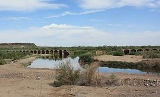
Gillespie Dam
Encyclopedia
The Gillespie Dam is a concrete
gravity dam
located on the Gila River
between the town
s of Buckeye
and Gila Bend
, Arizona
. The dam was constructed during the 1920s for primarily irrigation
purposes. A portion of the dam failed unexpectedly in 1993 during unusually heavy rains.
- constructed a concrete apron at the foot of the dam to allow for vehicular crossings. As the dam was a simple spillover construction, during times of heavy runoff cars would have to be pulled through the flow by trucks, and during floods could not cross at all.
In anticipation of the formation of the United States Highway System
in 1926, the Highway Department commissioned the construction of a steel
truss bridge
just downstream from the dam. The bridge was completed and opened to traffic on August 1, 1927 at a cost of US
$320,000 (US$3,950,000 in 2007). The bridge, which was at the time the longest highway bridge in the state of Arizona, was immediately incorporated into the highway system as Route 80. The bridge carried US 80 traffic until 1956 when the highway was decommissioned, devolving to a county highway, thus placing the bridge under Maricopa County care. The bridge was added to the National Register of Historic Places
on May 5, 1981.
, a major tributary to the Gila upstream from the Gillespie Dam. At approximately 10:30 on the morning of January 9, the dam failed when a segment approximately 120 feet (36.6 m) in length collapsed into the river. While the precise cause of the failure is unknown, the extreme flooding was almost certainly a contributing factor. The precise size of the flood was not recorded due to equipment failure, but an estimate based upon a high water mark recorded on USGS
equipment yielded a peak flow of approximately 200000 cubic feet (5,663.4 m³) per second, corresponding to a predicted 65-year flood
, or a flood of a magnitude anticipated only once per 65 years. The previous high, recorded during similarly disastrous floods in 1980, had been 178000 cubic feet (5,040.4 m³) per second.
Due to the failure, three underground natural gas
lines were exposed and later severed by the floodwaters. The bridge downstream survived, and was deemed safe for travel.
The remnants of the dam remain in place and the area is largely accessible to the public. A small earthen embankment exists to divert water into nearby canal
s.
Concrete
Concrete is a composite construction material, composed of cement and other cementitious materials such as fly ash and slag cement, aggregate , water and chemical admixtures.The word concrete comes from the Latin word...
gravity dam
Dam
A dam is a barrier that impounds water or underground streams. Dams generally serve the primary purpose of retaining water, while other structures such as floodgates or levees are used to manage or prevent water flow into specific land regions. Hydropower and pumped-storage hydroelectricity are...
located on the Gila River
Gila River
The Gila River is a tributary of the Colorado River, 650 miles long, in the southwestern states of New Mexico and Arizona.-Description:...
between the town
Town
A town is a human settlement larger than a village but smaller than a city. The size a settlement must be in order to be called a "town" varies considerably in different parts of the world, so that, for example, many American "small towns" seem to British people to be no more than villages, while...
s of Buckeye
Buckeye, Arizona
Buckeye is a town in Maricopa County, Arizona, United States and is the westernmost suburb in the Phoenix metropolitan area. The population of the town as of Census 2010 was 50,876, a 678% increase from the 2000 population of 6,537.-Geography:...
and Gila Bend
Gila Bend, Arizona
Gila Bend , founded in 1872, is a town in Maricopa County, Arizona, United States. The town is named for an approximately 90-degree bend in the Gila River, which is close to but not precisely at the community's current location...
, Arizona
Arizona
Arizona ; is a state located in the southwestern region of the United States. It is also part of the western United States and the mountain west. The capital and largest city is Phoenix...
. The dam was constructed during the 1920s for primarily irrigation
Irrigation
Irrigation may be defined as the science of artificial application of water to the land or soil. It is used to assist in the growing of agricultural crops, maintenance of landscapes, and revegetation of disturbed soils in dry areas and during periods of inadequate rainfall...
purposes. A portion of the dam failed unexpectedly in 1993 during unusually heavy rains.
History
The Gillespie Dam was constructed in 1921 by a local rancher to replace an existing structure. As the dam was located at an important river crossing that would later become US Route 80, the Arizona Highway Department - the predecessor to the Arizona Department of TransportationArizona Department of Transportation
The Arizona Department of Transportation is an Arizona state government agency charged with facilitating mobility within the state. In addition to managing the state's highway system, the agency is also involved with public transportation and municipal airports...
- constructed a concrete apron at the foot of the dam to allow for vehicular crossings. As the dam was a simple spillover construction, during times of heavy runoff cars would have to be pulled through the flow by trucks, and during floods could not cross at all.
In anticipation of the formation of the United States Highway System
United States Numbered Highways
The system of United States Numbered Highways is an integrated system of roads and highways in the United States numbered within a nationwide grid...
in 1926, the Highway Department commissioned the construction of a steel
Steel
Steel is an alloy that consists mostly of iron and has a carbon content between 0.2% and 2.1% by weight, depending on the grade. Carbon is the most common alloying material for iron, but various other alloying elements are used, such as manganese, chromium, vanadium, and tungsten...
truss bridge
Truss bridge
A truss bridge is a bridge composed of connected elements which may be stressed from tension, compression, or sometimes both in response to dynamic loads. Truss bridges are one of the oldest types of modern bridges...
just downstream from the dam. The bridge was completed and opened to traffic on August 1, 1927 at a cost of US
United States dollar
The United States dollar , also referred to as the American dollar, is the official currency of the United States of America. It is divided into 100 smaller units called cents or pennies....
$320,000 (US$3,950,000 in 2007). The bridge, which was at the time the longest highway bridge in the state of Arizona, was immediately incorporated into the highway system as Route 80. The bridge carried US 80 traffic until 1956 when the highway was decommissioned, devolving to a county highway, thus placing the bridge under Maricopa County care. The bridge was added to the National Register of Historic Places
National Register of Historic Places
The National Register of Historic Places is the United States government's official list of districts, sites, buildings, structures, and objects deemed worthy of preservation...
on May 5, 1981.
Failure
The winter months of 1993 saw unusually high rainfall amounts that resulted in record flows through central Arizona rivers and streams, including the Salt RiverSalt River (Arizona)
The Salt River is a stream in the U.S. state of Arizona. It is the largest tributary of the Gila River. The river is about long. Its drainage basin is about large. The longest of the Salt River's many tributaries is the Verde River...
, a major tributary to the Gila upstream from the Gillespie Dam. At approximately 10:30 on the morning of January 9, the dam failed when a segment approximately 120 feet (36.6 m) in length collapsed into the river. While the precise cause of the failure is unknown, the extreme flooding was almost certainly a contributing factor. The precise size of the flood was not recorded due to equipment failure, but an estimate based upon a high water mark recorded on USGS
United States Geological Survey
The United States Geological Survey is a scientific agency of the United States government. The scientists of the USGS study the landscape of the United States, its natural resources, and the natural hazards that threaten it. The organization has four major science disciplines, concerning biology,...
equipment yielded a peak flow of approximately 200000 cubic feet (5,663.4 m³) per second, corresponding to a predicted 65-year flood
100-year flood
A one-hundred-year flood is calculated to be the level of flood water expected to be equaled or exceeded every 100 years on average. The 100-year flood is more accurately referred to as the 1% annual exceedance probability flood, since it is a flood that has a 1% chance of being equaled or exceeded...
, or a flood of a magnitude anticipated only once per 65 years. The previous high, recorded during similarly disastrous floods in 1980, had been 178000 cubic feet (5,040.4 m³) per second.
Due to the failure, three underground natural gas
Natural gas
Natural gas is a naturally occurring gas mixture consisting primarily of methane, typically with 0–20% higher hydrocarbons . It is found associated with other hydrocarbon fuel, in coal beds, as methane clathrates, and is an important fuel source and a major feedstock for fertilizers.Most natural...
lines were exposed and later severed by the floodwaters. The bridge downstream survived, and was deemed safe for travel.
The remnants of the dam remain in place and the area is largely accessible to the public. A small earthen embankment exists to divert water into nearby canal
Canal
Canals are man-made channels for water. There are two types of canal:#Waterways: navigable transportation canals used for carrying ships and boats shipping goods and conveying people, further subdivided into two kinds:...
s.