
Interstate 95 in Georgia
Encyclopedia
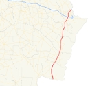
Interstate 95, the main Interstate Highway on the east coast of the United States
, serves the Atlantic coast
of Georgia. It begins at the St. Marys River at the Florida state line north of Jacksonville and heads north past the border of South Carolina
at the Savannah River. Interstate 95 in Georgia is designated — but not signed — as State Route 405.
corridor, passing near or through marshlands, and is close to the Atlantic coastline.
The State Welcome Centers on both ends of I-95 are integrated with other interchanges. The northbound Welcome Center is built into the northbound off-ramp with Exit 1, while the on-ramp from here runs under a bridge beneath the same off-ramp before leading back onto northbound I-95. The southbound Welcome Center can be found just after the off-ramp for first southbound truck weighing center, only for both facilities to share an on ramp back to southbound I-95. Other rest areas, weigh stations, and visitors centers operate independently with no access to any other facilities or destinations.
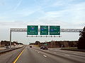 I-95 intersects Interstate 16
near Savannah
(Exit 99 A & B). Ramps to and from the eastbound lanes of I-16 feature barrier gates to prevent traffic from entering I-16 in the wrong direction during contraflow lane reversal
for hurricane evacuation
s.
The only auxiliary route for I-95 in Georgia is a Business Loop in Darien
. Another Business Loop used to exist for Brunswick
however.
passed a resolution to designate the portion of Interstate 95 between the Ogeechee River
(Bryan County, Georgia
-Chatham County, Georgia
border) north to the Savannah River
(Effingham County, Georgia
-Jasper County, South Carolina border) in the Greater Savannah Area
as the Tom P. Coleman Highway, in honor of Tom Coleman, a Democrat who served as State Senator from 1981 to 1995.
Until 2000, the state of Georgia used the sequential interchange numbering system on all of its Interstate Highways. The first exit on each highway would begin with the number "1" and increase numerically with each exit. In 2000, the Georgia Department of Transportation switched to a mileage-based exit system, in which the exit number corresponded to the nearest milepost.
Construction to widen I-95 from two to three lanes started with the Chatham County segment in 1993, with the other county segments done in phases, with the project completed throughout Georgia on December 10, 2010.
. It then joins US 17
(Ocean Highway) and follows the road north in a triple concurrency. After GA 99 separates to the northeast in downtown Darien, I-BL-95 turns northwest onto Georgia State Route 251
where it reunites with I-95 at it's northern terminus on Exit 49.
between Exits 29 and 38 (former Exits 6 and 8). It was cosigned with US 17
and Georgia State Route 25 but no longer exists. The route returned to I-95 via Georgia 25 Connection.
East Coast of the United States
The East Coast of the United States, also known as the Eastern Seaboard, refers to the easternmost coastal states in the United States, which touch the Atlantic Ocean and stretch up to Canada. The term includes the U.S...
, serves the Atlantic coast
Atlantic Coast
The Atlantic Coast is any coast fronting the Atlantic Ocean. The term differentiates the coasts of countries or continents with coastlines on more than one body of water, such as North America, South America, Africa and Europe.-See also:*Indian Ocean...
of Georgia. It begins at the St. Marys River at the Florida state line north of Jacksonville and heads north past the border of South Carolina
South Carolina
South Carolina is a state in the Deep South of the United States that borders Georgia to the south, North Carolina to the north, and the Atlantic Ocean to the east. Originally part of the Province of Carolina, the Province of South Carolina was one of the 13 colonies that declared independence...
at the Savannah River. Interstate 95 in Georgia is designated — but not signed — as State Route 405.
Route description
All of Interstate 95 in Georgia has at least three lanes in each direction, except in the Brunswick Area where it has four lanes in each direction. From northern Florida to west of Savannah, Interstate 95 travels along the US 17U.S. Route 17 in Georgia
U.S. Route 17 in Georgia runs north–south near the Atlantic Ocean, serving Brunswick and Savannah on its path from Florida at the St. Marys River to South Carolina at the Savannah River...
corridor, passing near or through marshlands, and is close to the Atlantic coastline.
The State Welcome Centers on both ends of I-95 are integrated with other interchanges. The northbound Welcome Center is built into the northbound off-ramp with Exit 1, while the on-ramp from here runs under a bridge beneath the same off-ramp before leading back onto northbound I-95. The southbound Welcome Center can be found just after the off-ramp for first southbound truck weighing center, only for both facilities to share an on ramp back to southbound I-95. Other rest areas, weigh stations, and visitors centers operate independently with no access to any other facilities or destinations.
Interstate 16
Interstate 16 , also known as Jim Gillis Historic Savannah Parkway or State Route 404 , is an intrastate Interstate Highway located entirely within the state of Georgia, United States...
near Savannah
Savannah, Georgia
Savannah is the largest city and the county seat of Chatham County, in the U.S. state of Georgia. Established in 1733, the city of Savannah was the colonial capital of the Province of Georgia and later the first state capital of Georgia. Today Savannah is an industrial center and an important...
(Exit 99 A & B). Ramps to and from the eastbound lanes of I-16 feature barrier gates to prevent traffic from entering I-16 in the wrong direction during contraflow lane reversal
Contraflow lane reversal
Contraflow lane reversal refers to plans that alter the normal flow of traffic, typically on a controlled-access highway , to either aid in an emergency evacuation or, as part of routine maintenance activities, to facilitate widening or reconstruction of one of the highway's carriageways...
for hurricane evacuation
Emergency evacuation
Emergency evacuation is the immediate and rapid movement of people away from the threat or actual occurrence of a hazard. Examples range from the small scale evacuation of a building due to a bomb threat or fire to the large scale evacuation of a district because of a flood, bombardment or...
s.
The only auxiliary route for I-95 in Georgia is a Business Loop in Darien
Darien, Georgia
Darien is a city in McIntosh County, Georgia, United States. It lies on Georgia's coast at the mouth of the Altamaha River about 50 miles south of Savannah, and is part of the Brunswick, Georgia Metropolitan Statistical Area. The population of Darien was 1,719 at the 2000 census. The city is the...
. Another Business Loop used to exist for Brunswick
Brunswick, Georgia
Brunswick is the major urban and economic center in southeastern Georgia in the United States. The municipality is located on a harbor near the Atlantic Ocean, approximately 30 miles north of Florida and 70 miles south of South Carolina. Brunswick is bordered on the east by the Atlantic...
however.
Service areas
- Northbound Welcome Center (Northbound off-ramp at Exit 1).
- Glynn County Rest Area (MM #41, between Exits 42 & 38: Southbound Only).
- McIntosh County Truck Weigh Stations (Between MM's 54 & 55: Both Directions).
- Southbound Welcome Center (North of Exit 109).
- Southbound Truck Weigh Station and Welcome Center (North of Exit 109).
History
In 1998, the Georgia State SenateGeorgia Senate
The Georgia State Senate is the upper house of the Georgia General Assembly .-Composition:According to the state constitution of 1983, this body is to be composed of no more than 56 members elected for two-year terms. Current state law provides for 56 members...
passed a resolution to designate the portion of Interstate 95 between the Ogeechee River
Ogeechee River
Ogeechee River is a river in the U.S. state of Georgia. It heads at the confluence of its North and South Forks, about south-southwest of Crawfordville and flowing generally southeast to Ossabaw Sound about south of Savannah. Its largest tributary is the Canoochee River...
(Bryan County, Georgia
Bryan County, Georgia
Bryan County is a county located in the U.S. state of Georgia. As of 2000, the population was 23,417. The 2007 Census Estimate shows a population of 30,132...
-Chatham County, Georgia
Chatham County, Georgia
Chatham County is a county located in the U.S. state of Georgia. The county seat and largest city is Savannah. In the official US Census of 2010, Chatham County had a total population of 265,128 . Chatham is the most populous Georgia county outside the Atlanta metropolitan area...
border) north to the Savannah River
Savannah River
The Savannah River is a major river in the southeastern United States, forming most of the border between the states of South Carolina and Georgia. Two tributaries of the Savannah, the Tugaloo River and the Chattooga River, form the northernmost part of the border...
(Effingham County, Georgia
Effingham County, Georgia
Effingham County is a county located in the U.S. state of Georgia. In the United States Census of 2000, the population was 37,535. The Census Bureau's 2008 estimate estimates that this figure has grown to 52,060. The seat of Effingham County is Springfield....
-Jasper County, South Carolina border) in the Greater Savannah Area
Savannah, Georgia
Savannah is the largest city and the county seat of Chatham County, in the U.S. state of Georgia. Established in 1733, the city of Savannah was the colonial capital of the Province of Georgia and later the first state capital of Georgia. Today Savannah is an industrial center and an important...
as the Tom P. Coleman Highway, in honor of Tom Coleman, a Democrat who served as State Senator from 1981 to 1995.
Until 2000, the state of Georgia used the sequential interchange numbering system on all of its Interstate Highways. The first exit on each highway would begin with the number "1" and increase numerically with each exit. In 2000, the Georgia Department of Transportation switched to a mileage-based exit system, in which the exit number corresponded to the nearest milepost.
Construction to widen I-95 from two to three lanes started with the Chatham County segment in 1993, with the other county segments done in phases, with the project completed throughout Georgia on December 10, 2010.
Exit list
Darien Business Route
The Interstate 95 Business Loop for Darien, Georgia begins at Exit 42 on I-95, and runs concurrent with Georgia State Route 99Georgia State Route 99
State Route 99 is a state highway located in southeast Georgia in Glynn County and McIntosh County. It roughly follows an old Indian trading trail....
. It then joins US 17
U.S. Route 17 in Georgia
U.S. Route 17 in Georgia runs north–south near the Atlantic Ocean, serving Brunswick and Savannah on its path from Florida at the St. Marys River to South Carolina at the Savannah River...
(Ocean Highway) and follows the road north in a triple concurrency. After GA 99 separates to the northeast in downtown Darien, I-BL-95 turns northwest onto Georgia State Route 251
Georgia State Route 251
State Route 251 is a north–south state route located in McIntosh County in the southeastern part of the U.S. state of Georgia. From the route's southern terminus at U.S. Route 17/State Route 25 in Darien, the route runs northwest, intersecting Interstate 95 northwest of the city. The route...
where it reunites with I-95 at it's northern terminus on Exit 49.
Former Brunswick Business Loop
The former Interstate 95 Business Loop for Brunswick, Georgia used to serve Brunswick and the Golden IslesThe Golden Isles of Georgia
The Golden Isles of Georgia are a group of four barrier islands on the 100-mile-long coast of Georgia on the Atlantic Ocean. They include St. Simons Island, Sea Island, Jekyll Island, Little St. Simons Island, and Historic Brunswick. They are part of the Sea Islands.Since the American Civil War,...
between Exits 29 and 38 (former Exits 6 and 8). It was cosigned with US 17
U.S. Route 17 in Georgia
U.S. Route 17 in Georgia runs north–south near the Atlantic Ocean, serving Brunswick and Savannah on its path from Florida at the St. Marys River to South Carolina at the Savannah River...
and Georgia State Route 25 but no longer exists. The route returned to I-95 via Georgia 25 Connection.