

Old Plank Road
Encyclopedia
The Old Plank Road is a plank road
in Imperial County, California
that was built in 1915 as an east–west route over the Algodones Dunes
. It effectively connected the extreme lower section of Southern California
to Arizona
and provided the last link in a commercial route between San Diego and Yuma
.
, San Diego's civic leaders proposed the Plank Road to ensure their city became the hub of Southern California's road network rather than Los Angeles
.
Among those promoters was businessman and road builder "Colonel" Ed Fletcher
who accepted a challenge from the Los Angeles Examiner
to run a road race in October 1912 to determine the best route between Southern California and Phoenix
. A reporter with the paper was given a 24-hour head start
in Los Angeles; Fletcher would proceed from San Diego. Fletcher elected to traverse the constantly shifting sand dunes using a team of horses to pull his automobile through the sand, and won the race in a seemingly impossible 19.5 hours.
Buoyed by the success of the race and with the backing of local newspapers, Fletcher raised the money to pay for 13,000 planks shipped from San Diego to Holtville, California
. The first planks were laid on February 14, 1915 with the help of both volunteers and paid labor. The roadbed consisted of two parallel plank tracks, each 25 inches/63.5 cm wide, spiked to wooden crosspieces laid underneath. Total length of the Plank Road was 6.5 miles/10.4 km. Work ended nearly two months later on April 4.
Though traffic and maintenance crews who cleared the wooden road with mule-drawn scrapers soon took its toll on the planking, the road was considered a success. In June that same year, the California State Highway Commission
assumed responsibility for the Plank Road as part of the road system linking Southern California with Arizona.
A second, more sophisticated Plank Road was commissioned in 1916. The new roadway consisted of prefabricated wooden sections laid to a width of 8 feet/2.4 m with double-width turnouts every 1000 feet/305 m. The sections were shipped to the work site via horse-drawn wagon from their assembly point in nearby Ogilby
, and then lowered into place using a crane.
For the next ten years, work crews struggled against the elements to keep the Plank Road open. The cost and difficulty of the maintenance coupled with improved road technology — not to mention the incredibly rough ride the planks created and the fact that the road was only wide enough for a single vehicle — meant that the days of the Plank Road were numbered.
A new, 20-foot/6-meter-wide road with an asphaltic concrete surface constructed on top of a built-up sand embankment replaced the Old Plank Road upon its opening on August 12, 1926. This same roadway would later become displaced by U.S. Route 80, itself since displaced by Interstate 8.
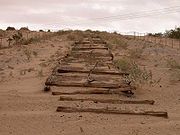 Today, only fragments of the Plank Road remain. They are protected under the jurisdiction of the Bureau of Land Management
. Additionally, the fragments are both a California Historical Landmark and eligible for inclusion in the National Register of Historic Places
. Remnants of the Plank Road may be seen at the west end of Grays Well Road, a frontage road
south of I-8. A monument to the Plank Road and interpretive display lie approximately three miles/5.4 km west of the Sand Hills interchange. The monument's largest feature is a 1500-foot/457-meter-long replica of the road created in the early 1970s out of existing fragments.
Plank road
A plank road or puncheon is a dirt path or road covered with a series of planks, similar to the wooden sidewalks one would see in a Western movie. Plank roads were very popular in Ontario, the U.S. Northeast and U.S. Midwest in the first half of the 19th century...
in Imperial County, California
Imperial County, California
Imperial County is a county located in the Imperial Valley, in the far southeast of the U.S. state of California, bordering both Arizona and Mexico. It is part of the El Centro Metropolitan Area, which encompasses all of Imperial County. The population as of 2000 was 142,361. The county seat is the...
that was built in 1915 as an east–west route over the Algodones Dunes
Algodones Dunes
The Algodones Dunes is a large erg located in the southeastern portion of the U.S. state of California, near the border with Arizona and the Mexican state of Baja California. The field is approximately 45 miles long by 6 miles wide and extends along a northwest-southeast line that correlates to...
. It effectively connected the extreme lower section of Southern California
Southern California
Southern California is a megaregion, or megapolitan area, in the southern area of the U.S. state of California. Large urban areas include Greater Los Angeles and Greater San Diego. The urban area stretches along the coast from Ventura through the Southland and Inland Empire to San Diego...
to Arizona
Arizona
Arizona ; is a state located in the southwestern region of the United States. It is also part of the western United States and the mountain west. The capital and largest city is Phoenix...
and provided the last link in a commercial route between San Diego and Yuma
Yuma, Arizona
Yuma is a city in and the county seat of Yuma County, Arizona, United States. It is located in the southwestern corner of the state, and the population of the city was 77,515 at the 2000 census, with a 2008 Census Bureau estimated population of 90,041....
.
History
Following Los Angeles' winning the right to be the western terminus of the transcontinental railroadTranscontinental railroad
A transcontinental railroad is a contiguous network of railroad trackage that crosses a continental land mass with terminals at different oceans or continental borders. Such networks can be via the tracks of either a single railroad, or over those owned or controlled by multiple railway companies...
, San Diego's civic leaders proposed the Plank Road to ensure their city became the hub of Southern California's road network rather than Los Angeles
Los Ángeles
Los Ángeles is the capital of the province of Biobío, in the commune of the same name, in Region VIII , in the center-south of Chile. It is located between the Laja and Biobío rivers. The population is 123,445 inhabitants...
.
Among those promoters was businessman and road builder "Colonel" Ed Fletcher
Ed Fletcher
"Colonel" Ed Fletcher was a real estate developer and U.S. Republican and Democratic politician from San Diego, California.Fletcher was born 1872 in Littleton, Massachusetts, son of Charles Kimball Fletcher....
who accepted a challenge from the Los Angeles Examiner
Los Angeles Herald-Examiner
The Los Angeles Herald Examiner was a major Los Angeles daily newspaper, published Monday through Friday in the afternoon, and in the morning on Saturdays and Sundays. It was part of the Hearst syndicate. The afternoon Herald-Express and the morning Examiner, both of which had been publishing in...
to run a road race in October 1912 to determine the best route between Southern California and Phoenix
Phoenix, Arizona
Phoenix is the capital, and largest city, of the U.S. state of Arizona, as well as the sixth most populated city in the United States. Phoenix is home to 1,445,632 people according to the official 2010 U.S. Census Bureau data...
. A reporter with the paper was given a 24-hour head start
Head start (positioning)
In positioning, a head start is a start in advance of the starting position of others in competition, or simply toward the finish line or desired outcome...
in Los Angeles; Fletcher would proceed from San Diego. Fletcher elected to traverse the constantly shifting sand dunes using a team of horses to pull his automobile through the sand, and won the race in a seemingly impossible 19.5 hours.
Buoyed by the success of the race and with the backing of local newspapers, Fletcher raised the money to pay for 13,000 planks shipped from San Diego to Holtville, California
Holtville, California
Holtville is a city in Imperial County, California. Holtville is located east of El Centro, The population was 5,939 at the 2010 census, up from 5,612 at the 2000 census. It is part of the 'El Centro, California, Metropolitan Statistical Area'...
. The first planks were laid on February 14, 1915 with the help of both volunteers and paid labor. The roadbed consisted of two parallel plank tracks, each 25 inches/63.5 cm wide, spiked to wooden crosspieces laid underneath. Total length of the Plank Road was 6.5 miles/10.4 km. Work ended nearly two months later on April 4.
Though traffic and maintenance crews who cleared the wooden road with mule-drawn scrapers soon took its toll on the planking, the road was considered a success. In June that same year, the California State Highway Commission
California Department of Transportation
The California Department of Transportation is a government department in the U.S. state of California. Its mission is to improve mobility across the state. It manages the state highway system and is actively involved with public transportation systems throughout the state...
assumed responsibility for the Plank Road as part of the road system linking Southern California with Arizona.
A second, more sophisticated Plank Road was commissioned in 1916. The new roadway consisted of prefabricated wooden sections laid to a width of 8 feet/2.4 m with double-width turnouts every 1000 feet/305 m. The sections were shipped to the work site via horse-drawn wagon from their assembly point in nearby Ogilby
Ogilby, California
Ogilby is an unincorporated community in Imperial County, California. Ogilby is located on the Southern Pacific Railroad east of El Centro, and 3.8 miles north of Interstate 8 on County Road S34. The name is official for federal use and a feature ID Number of 252950 has been assigned...
, and then lowered into place using a crane.
For the next ten years, work crews struggled against the elements to keep the Plank Road open. The cost and difficulty of the maintenance coupled with improved road technology — not to mention the incredibly rough ride the planks created and the fact that the road was only wide enough for a single vehicle — meant that the days of the Plank Road were numbered.
A new, 20-foot/6-meter-wide road with an asphaltic concrete surface constructed on top of a built-up sand embankment replaced the Old Plank Road upon its opening on August 12, 1926. This same roadway would later become displaced by U.S. Route 80, itself since displaced by Interstate 8.
Bureau of Land Management
The Bureau of Land Management is an agency within the United States Department of the Interior which administers America's public lands, totaling approximately , or one-eighth of the landmass of the country. The BLM also manages of subsurface mineral estate underlying federal, state and private...
. Additionally, the fragments are both a California Historical Landmark and eligible for inclusion in the National Register of Historic Places
National Register of Historic Places
The National Register of Historic Places is the United States government's official list of districts, sites, buildings, structures, and objects deemed worthy of preservation...
. Remnants of the Plank Road may be seen at the west end of Grays Well Road, a frontage road
Frontage road
A frontage road is a non-limited access road running parallel to a higher-speed road, usually a freeway, and feeding it at appropriate points of access...
south of I-8. A monument to the Plank Road and interpretive display lie approximately three miles/5.4 km west of the Sand Hills interchange. The monument's largest feature is a 1500-foot/457-meter-long replica of the road created in the early 1970s out of existing fragments.