
Little San Bernardino Mountains
Encyclopedia
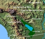
The Little San Bernardino Mountains are a short mountain range
of the Transverse Ranges
, located in southern California
in the United States
. They extend for approximately 40 mi (64 km) southeast from the San Bernardino Mountains
through San Bernardino
and Riverside
Counties to near the northeast edge of the Salton Sink
and Salton Sea
.
The community of Palm Springs
looks north across the Coachella Valley to the range.
in the Colorado Desert
on the south to the Mojave Desert
on the north. The peaks vary in height from approximately 4,000–5,000 ft (1,200–1,650 m). The range highpoint is Quail Mountain (California)
, elevation 5,813' (1,772 m).
. Big Morongo Canyon Preserve
is also located in the Little San Bernardino Mountains. The oasis
here contains one of the ten largest cottonwood (Populus fremontii
) and red willow
(Salix laevigata) Riparian zone
habitats in California. It was identified as an area of concern by the Bureau of Land Management in 1982. The only native palm to California, Washingtonia filifera
, or the Desert fan palm which is an endangered species in nature while prevalent in gardens.
, which provides drinking water for Los Angeles
, San Bernardino
, and San Diego
, runs along the southwest edge of the mountains.
Colorado Desert index
Mountain range
A mountain range is a single, large mass consisting of a succession of mountains or narrowly spaced mountain ridges, with or without peaks, closely related in position, direction, formation, and age; a component part of a mountain system or of a mountain chain...
of the Transverse Ranges
Transverse Ranges
The Transverse Ranges are a group of mountain ranges of southern California, in the Pacific Coast Ranges physiographic region that runs along the Pacific coast from Alaska to Mexico in North America. The Transverse Ranges begin at the southern end of the California Coast Ranges and lie between...
, located in southern California
California
California is a state located on the West Coast of the United States. It is by far the most populous U.S. state, and the third-largest by land area...
in the United States
United States
The United States of America is a federal constitutional republic comprising fifty states and a federal district...
. They extend for approximately 40 mi (64 km) southeast from the San Bernardino Mountains
San Bernardino Mountains
The San Bernardino Mountains are a short transverse mountain range north and east of San Bernardino in Southern California in the United States. The mountains run for approximately 60 miles east-west on the southern edge of the Mojave Desert in southwestern San Bernardino County, north of the...
through San Bernardino
San Bernardino County, California
San Bernardino County is a county in the U.S. state of California. As of the 2010 census, the population was 2,035,210, up from 1,709,434 as of the 2000 census...
and Riverside
Riverside County, California
Riverside County is a county in the U.S. state of California. One of 58 California counties, it covers in the southern part of the state, and stretches from Orange County to the Colorado River, which forms the state border with Arizona. The county derives its name from the city of Riverside,...
Counties to near the northeast edge of the Salton Sink
Salton Sink
The Salton Sink is a geographic sink in the Coachella and Imperial valleys of southeastern California. It is in the Colorado Desert subregion of the Sonoran Desert ecoregion...
and Salton Sea
Salton Sea
The Salton Sea is a shallow, saline, endorheic rift lake located directly on the San Andreas Fault, predominantly in California's Imperial Valley. The lake occupies the lowest elevations of the Salton Sink in the Colorado Desert of Imperial and Riverside counties in Southern California. Like Death...
.
The community of Palm Springs
Palm Springs, California
Palm Springs is a desert city in Riverside County, California, within the Coachella Valley. It is located approximately 37 miles east of San Bernardino, 111 miles east of Los Angeles and 136 miles northeast of San Diego...
looks north across the Coachella Valley to the range.
Geography
The range transitions the separation from the Coachella ValleyCoachella Valley
Coachella Valley is a large valley landform in Southern California. The valley extends for approximately 45 miles in Riverside County southeast from the San Bernardino Mountains to the saltwater Salton Sea, the largest lake in California...
in the Colorado Desert
Colorado Desert
California's Colorado Desert is a part of the larger Sonoran Desert, which extends across southwest North America. The Colorado Desert region encompasses approximately , reaching from the Mexican border in the south to the higher-elevation Mojave Desert in the north and from the Colorado River in...
on the south to the Mojave Desert
Mojave Desert
The Mojave Desert occupies a significant portion of southeastern California and smaller parts of central California, southern Nevada, southwestern Utah and northwestern Arizona, in the United States...
on the north. The peaks vary in height from approximately 4,000–5,000 ft (1,200–1,650 m). The range highpoint is Quail Mountain (California)
Quail Mountain (California)
Quail Mountain, at , is the highest mountain in Joshua Tree National Park and the highest point in the Little San Bernardino Mountains of the very southern reach of the Mojave Desert...
, elevation 5,813' (1,772 m).
Habitats
Much of the eastern end of the range is within Joshua Tree National ParkJoshua Tree National Park
Joshua Tree National Park is located in southeastern California. Declared a U.S. National Park in 1994 when the U.S. Congress passed the California Desert Protection Act , it had previously been a U.S. National Monument since 1936. It is named for the Joshua tree forests native to the park...
. Big Morongo Canyon Preserve
Big Morongo Canyon Preserve
The Big Morongo Canyon Preserve is a 31,000 acres native plants habitat and wildlife preserve located in the Little San Bernardino Mountains of the Transverse Ranges, in the transition zone between the higher Mojave Desert and lower elevation Colorado Desert section of the Sonoran...
is also located in the Little San Bernardino Mountains. The oasis
Oasis
In geography, an oasis or cienega is an isolated area of vegetation in a desert, typically surrounding a spring or similar water source...
here contains one of the ten largest cottonwood (Populus fremontii
Populus fremontii
Populus fremontii, the Fremont cottonwood or Alamo cottonwood, is a cottonwood poplar native to western North America, in California and east to Nevada, Utah, Arizona, and New Mexico, and south into Sonora in northwestern Mexico...
) and red willow
Salix laevigata
Salix laevigata , is a perennial species of willow native to Pacific Coastal California and northern Baja California; it occurs in other southwestern United States locales, most prominently in Arizona and southwest Utah.The Red Willow is a small tree up to 45 feet in height.-Distribution:Most of...
(Salix laevigata) Riparian zone
Riparian zone
A riparian zone or riparian area is the interface between land and a river or stream. Riparian is also the proper nomenclature for one of the fifteen terrestrial biomes of the earth. Plant habitats and communities along the river margins and banks are called riparian vegetation, characterized by...
habitats in California. It was identified as an area of concern by the Bureau of Land Management in 1982. The only native palm to California, Washingtonia filifera
Washingtonia filifera
Washingtonia filifera , with the common names California Fan Palm , Desert Fan Palm, Cotton palm, and Arizona Fan Palm. It is a palm native to southwestern North America between an elevation range of , at seeps, desert bajadas, and springs where underground water is continuously available...
, or the Desert fan palm which is an endangered species in nature while prevalent in gardens.
Aqueduct
The Colorado River AqueductColorado River Aqueduct
The Colorado River Aqueduct, or CRA, is a water conveyance in Southern California in the United States, operated by the Metropolitan Water District of Southern California . The aqueduct impounds water from the Colorado River at Lake Havasu on the California-Arizona border west across the Mojave...
, which provides drinking water for Los Angeles
Los Angeles, California
Los Angeles , with a population at the 2010 United States Census of 3,792,621, is the most populous city in California, USA and the second most populous in the United States, after New York City. It has an area of , and is located in Southern California...
, San Bernardino
San Bernardino, California
San Bernardino is a city located in the Riverside-San Bernardino metropolitan area , and serves as the county seat of San Bernardino County, California, United States...
, and San Diego
San Diego, California
San Diego is the eighth-largest city in the United States and second-largest city in California. The city is located on the coast of the Pacific Ocean in Southern California, immediately adjacent to the Mexican border. The birthplace of California, San Diego is known for its mild year-round...
, runs along the southwest edge of the mountains.
See also
- CahuillaCahuillaThe Cahuilla, Iviatim in their own language, are Indians with a common culture whose ancestors inhabited inland areas of southern California 2,000 years ago. Their original territory included an area of about . The traditional Cahuilla territory was near the geographic center of Southern California...
Colorado Desert index
- Mojave Desert index