

Santa Ynez Mountains
Encyclopedia
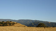
The Santa Ynez Mountains are a portion of the Transverse Ranges
, part of the Pacific Coast Ranges
of the west coast of North America, and are one of the northernmost mountain range
s in Southern California
.
The mountains extend from an eastern terminus at the canyon of the Ventura River
and Matilija Creek
, north of Ojai
, west across the Santa Barbara County line, to immediately north of the city of Santa Barbara
, and then west, paralleling the coast, to the city of Lompoc
and Vandenberg Air Force Base
. The Santa Ynez River
flows just north of the mountains, paralleling them for most of their length. Before reaching Lompoc the mountain range diverges into two low ranges, separated by Jalama Creek, which then vanish into the Pacific Ocean. The mountains parallel the Channel Islands to the south, another east-west trending range, a geologic extension of the Santa Monica Mountains
; the two ranges are about thirty miles apart. Principal summits in the Santa Ynez range include Divide Peak, 4707' (1434 m), La Cumbre Peak
, 3985' (1214 m) (above Santa Barbara), and Santa Ynez Peak, 4298' (1310 m). There are several important passes, including Gaviota Pass in the western portion of the range, through which runs U.S. Highway 101 via the Gaviota Tunnel
; and San Marcos Pass
near Santa Barbara, through which runs California State Route 154 capped by the magnificent Cold Spring Canyon Arch Bridge
near the summit.

s in the extreme western part of the range, and a small exposure of the metamorphic
Franciscan Formation north of Carpinteria, exclusively of sedimentary origin. They were uplifted in the late Miocene
Epoch, about five million years ago, along the Santa Ynez Fault
, a feature which is considered to be active. Being young, the slopes are steep and the topography is extremely rugged; the gradient is highest on the northern side, above the trace of the fault. Dramatic sandstone formations, including outcrops of the resistant Coldwater and Matilija
formations, are visible at many locations in the range.
, with coastal sage scrub
, oak woodland and grasslands at lower elevations. Isolated stands of conifers and other evergreen trees such as bay laurel, tanbark oak and madrone grow on the higher parts of the northern slopes, which are cooler and have a somewhat higher annual rainfall than the southern slopes. At lower elevations on the southern side of the range, a virtually frost-free zone, avocado
s are grown in considerable quantity.
including those at Painted Cave SHP
. Large portions of the mountain range are now in the Los Padres National Forest
, although there are private inholding
s, including some substantial communities, such as the Painted Cave
community where Jane Fonda
owned the ridgetop Laurel Springs Ranch
into the late 1990s. Other famous residents have included Ronald Reagan
, whose Rancho del Cielo
is at the top of the range west of Santa Barbara. The Cold Spring Tavern is a popular local gathering place beneath the Cold Spring Bridge
.
. Summers are warm and almost entirely rainless, save for occasional monsoon
al showers in August and September, though in most years there is no rain between May and October. Winters are mild and can be rainy, with sometimes over 40 inches (1,016 mm) of rain falling in the mountains (while only 15 inches (381 mm) falls on the coastal plain below due to the orographic effect of clouds dropping most of their moisture on the higher terrain). About one year in three snow falls on the higher peaks in the mountains, but it rarely stays for longer than a few days. In the late spring and early summer the mountains and areas below to the south are subject to occasional intense sundowner wind
s, a type of foehn wind in which the air is heated adiabatically and dried as it moves downslope. In dry years these winds pose an extreme fire hazard.
Occasionally extremely destructive fires originate in the Santa Ynez Mountains. In June 1990, a fire which began near Painted Cave burned south into the city of Santa Barbara, driven by sundowner winds, destroying over 500 homes. A fire in the 1940s destroyed most of the mansion that is now called Knapp's Castle
. More recent fires, such as the Tea and Jesusita fires, have also been destructive to properties.
Transverse Ranges
The Transverse Ranges are a group of mountain ranges of southern California, in the Pacific Coast Ranges physiographic region that runs along the Pacific coast from Alaska to Mexico in North America. The Transverse Ranges begin at the southern end of the California Coast Ranges and lie between...
, part of the Pacific Coast Ranges
Pacific Coast Ranges
The Pacific Coast Ranges and the Pacific Mountain System are the series of mountain ranges that stretch along the West Coast of North America from Alaska south to Northern and Central Mexico...
of the west coast of North America, and are one of the northernmost mountain range
Mountain range
A mountain range is a single, large mass consisting of a succession of mountains or narrowly spaced mountain ridges, with or without peaks, closely related in position, direction, formation, and age; a component part of a mountain system or of a mountain chain...
s in Southern California
Southern California
Southern California is a megaregion, or megapolitan area, in the southern area of the U.S. state of California. Large urban areas include Greater Los Angeles and Greater San Diego. The urban area stretches along the coast from Ventura through the Southland and Inland Empire to San Diego...
.
Geography
They are principally in Santa Barbara County, with an eastward extension into Ventura County, and are unusual in being an entirely east-west trending mountain range—one of the few in the United States.The mountains extend from an eastern terminus at the canyon of the Ventura River
Ventura River
The Ventura River is a river in Ventura County, California. The river forms at the confluence of Matilija Creek and North Fork Matilija Creek, upstream from the Pacific Ocean...
and Matilija Creek
Matilija Creek
Matilija Creek is a major stream in Ventura County in the U.S. state of California. It joins with North Fork Matilija Creek to form the Ventura River. Many tributaries feed the mostly free flowing, creek, which is largely contained in the Matilija Wilderness. It then forms the reservoir behind...
, north of Ojai
Ojai, California
Ojai is a city in Ventura County, California, USA. It is situated in the Ojai Valley , surrounded by hills and mountains. The population was 7,461 at the 2010 census, down from 7,862 at the 2000 census.-History:Chumash Indians were the early inhabitants of the valley...
, west across the Santa Barbara County line, to immediately north of the city of Santa Barbara
Santa Barbara, California
Santa Barbara is the county seat of Santa Barbara County, California, United States. Situated on an east-west trending section of coastline, the longest such section on the West Coast of the United States, the city lies between the steeply-rising Santa Ynez Mountains and the Pacific Ocean...
, and then west, paralleling the coast, to the city of Lompoc
Lompoc, California
Lompoc is a city in Santa Barbara County, California, United States. The city was incorporated in 1888. The population was 42,434 at the 2010 census, up from 41,103 at the 2000 census....
and Vandenberg Air Force Base
Vandenberg Air Force Base
Vandenberg Air Force Base is a United States Air Force Base, located approximately northwest of Lompoc, California. It is under the jurisdiction of the 30th Space Wing, Air Force Space Command ....
. The Santa Ynez River
Santa Ynez River
The Santa Ynez River is one of the largest rivers on the Central Coast of California. It is long, flowing from east to west through the Santa Ynez Valley, reaching the Pacific Ocean at Surf, near Vandenberg Air Force Base and the city of Lompoc....
flows just north of the mountains, paralleling them for most of their length. Before reaching Lompoc the mountain range diverges into two low ranges, separated by Jalama Creek, which then vanish into the Pacific Ocean. The mountains parallel the Channel Islands to the south, another east-west trending range, a geologic extension of the Santa Monica Mountains
Santa Monica Mountains
The Santa Monica Mountains are a Transverse Range in Southern California, along the coast of the Pacific Ocean in the United States.-Geography:...
; the two ranges are about thirty miles apart. Principal summits in the Santa Ynez range include Divide Peak, 4707' (1434 m), La Cumbre Peak
La Cumbre Peak
La Cumbre Peak is a 3,995 foot peak in the Santa Ynez Mountains north of Santa Barbara, California. Made up of boulders and slabs of the Matilija Sandstone amid groves of pine trees, it is the highest summit near to the city...
, 3985' (1214 m) (above Santa Barbara), and Santa Ynez Peak, 4298' (1310 m). There are several important passes, including Gaviota Pass in the western portion of the range, through which runs U.S. Highway 101 via the Gaviota Tunnel
Gaviota Tunnel
The Gaviota Tunnel is a tunnel on U.S. Route 101 completed in 1953 north of Gaviota State Park, 33 miles northwest of Santa Barbara, California. It is long and tall. Only the northbound lanes of U.S...
; and San Marcos Pass
San Marcos Pass
San Marcos Pass is a mountain pass in the Santa Ynez Mountains in California.It is traversed by State Route 154. The pass connects Los Olivos and the Santa Ynez Valley with Santa Barbara, California...
near Santa Barbara, through which runs California State Route 154 capped by the magnificent Cold Spring Canyon Arch Bridge
Cold Spring Canyon Arch Bridge
The Cold Spring Canyon Arch Bridge in the Santa Ynez Mountains links Santa Barbara, California with Santa Ynez, California. The bridge is signed as part of State Route 154. The current bridge was completed and opened to traffic in 1963 and won awards for engineering, design and beauty. It is...
near the summit.
Geology
Geologically the mountains are young, and with the exception of a few volcanic rockVolcanic rock
Volcanic rock is a rock formed from magma erupted from a volcano. In other words, it is an igneous rock of volcanic origin...
s in the extreme western part of the range, and a small exposure of the metamorphic
Metamorphic rock
Metamorphic rock is the transformation of an existing rock type, the protolith, in a process called metamorphism, which means "change in form". The protolith is subjected to heat and pressure causing profound physical and/or chemical change...
Franciscan Formation north of Carpinteria, exclusively of sedimentary origin. They were uplifted in the late Miocene
Miocene
The Miocene is a geological epoch of the Neogene Period and extends from about . The Miocene was named by Sir Charles Lyell. Its name comes from the Greek words and and means "less recent" because it has 18% fewer modern sea invertebrates than the Pliocene. The Miocene follows the Oligocene...
Epoch, about five million years ago, along the Santa Ynez Fault
Santa Ynez Fault
Santa Ynez Fault is a left-reverse fault in Santa Barbara County of California. Its length is at least 130 km., running through Santa Ynez and nearby Santa Barbara. The Santa Ynez Mountains were uplifted within the last 5 million years along this fault....
, a feature which is considered to be active. Being young, the slopes are steep and the topography is extremely rugged; the gradient is highest on the northern side, above the trace of the fault. Dramatic sandstone formations, including outcrops of the resistant Coldwater and Matilija
Matilija Sandstone
The Matilija Sandstone is a sedimentary geologic unit of Eocene age, found in Santa Barbara and Ventura Counties in Southern California. It consists of thick layers of sandstone, made up of grains of feldspar and quartz from a granitic source rock, interbedded with thin layers of siltstone and shale...
formations, are visible at many locations in the range.
Biology
The predominant ground cover is chaparralChaparral
Chaparral is a shrubland or heathland plant community found primarily in the U.S. state of California and in the northern portion of the Baja California peninsula, Mexico...
, with coastal sage scrub
Coastal sage scrub
Coastal sage scrub is a low scrubland plant community found in the California chaparral and woodlands ecoregion of coastal California and northern Baja California. It is characterized by low-growing aromatic, and drought-deciduous shrubs adapted to the semi-arid Mediterranean climate of the...
, oak woodland and grasslands at lower elevations. Isolated stands of conifers and other evergreen trees such as bay laurel, tanbark oak and madrone grow on the higher parts of the northern slopes, which are cooler and have a somewhat higher annual rainfall than the southern slopes. At lower elevations on the southern side of the range, a virtually frost-free zone, avocado
Avocado
The avocado is a tree native to Central Mexico, classified in the flowering plant family Lauraceae along with cinnamon, camphor and bay laurel...
s are grown in considerable quantity.
Inhabitants
Early inhabitants included the Chumash people who left behind many examples of Rock artRock art
Rock art is a term used in archaeology for any human-made markings made on natural stone. They can be divided into:*Petroglyphs - carvings into stone surfaces*Pictographs - rock and cave paintings...
including those at Painted Cave SHP
Chumash Painted Cave State Historic Park, California
Chumash Painted Cave State Historic Park is a unit in the state park system of California, USA, preserving a small sandstone cave adorned with rock art attributed to the Chumash people. Adjoining the small community of Painted Cave, the site is located about north of California State Route 154...
. Large portions of the mountain range are now in the Los Padres National Forest
Los Padres National Forest
Los Padres National Forest is a forest located in southern and central California, which includes most of the mountainous land along the California coast from Ventura to Monterey, extending inland...
, although there are private inholding
Inholding
An inholding is privately owned land inside the boundary of a national park, national forest, state park, or similar publicly owned, protected area...
s, including some substantial communities, such as the Painted Cave
Painted Cave, California
Painted Cave is an unincorporated community located in the Santa Ynez Mountains and is so named due to its proximity to Painted Cave State Historic Park. It is primarily served by Camino Cielo Road and California State Route 154, which link the community both to the nearby Santa Ynez Valley and...
community where Jane Fonda
Jane Fonda
Jane Fonda is an American actress, writer, political activist, former fashion model, and fitness guru. She rose to fame in the 1960s with films such as Barbarella and Cat Ballou. She has won two Academy Awards and received several other movie awards and nominations during more than 50 years as an...
owned the ridgetop Laurel Springs Ranch
Laurel Springs Ranch
Laurel Springs Ranch is a ranch located on a ridgetop in the Santa Ynez Mountain range northwest of Santa Barbara, California, between the Painted Cave community and the intersection of Painted Cave road with East Camino Cielo Road in the Los Padres National Forest.-History:Homer Snyder developed...
into the late 1990s. Other famous residents have included Ronald Reagan
Ronald Reagan
Ronald Wilson Reagan was the 40th President of the United States , the 33rd Governor of California and, prior to that, a radio, film and television actor....
, whose Rancho del Cielo
Rancho del Cielo
Rancho del Cielo, or "Sky's or Heaven's Ranch," is a ranch located on the top of the Santa Ynez Mountain range northwest of Santa Barbara, California...
is at the top of the range west of Santa Barbara. The Cold Spring Tavern is a popular local gathering place beneath the Cold Spring Bridge
Cold Spring Canyon Arch Bridge
The Cold Spring Canyon Arch Bridge in the Santa Ynez Mountains links Santa Barbara, California with Santa Ynez, California. The bridge is signed as part of State Route 154. The current bridge was completed and opened to traffic in 1963 and won awards for engineering, design and beauty. It is...
.
Climate
The climate of the mountain range is MediterraneanMediterranean climate
A Mediterranean climate is the climate typical of most of the lands in the Mediterranean Basin, and is a particular variety of subtropical climate...
. Summers are warm and almost entirely rainless, save for occasional monsoon
Monsoon
Monsoon is traditionally defined as a seasonal reversing wind accompanied by corresponding changes in precipitation, but is now used to describe seasonal changes in atmospheric circulation and precipitation associated with the asymmetric heating of land and sea...
al showers in August and September, though in most years there is no rain between May and October. Winters are mild and can be rainy, with sometimes over 40 inches (1,016 mm) of rain falling in the mountains (while only 15 inches (381 mm) falls on the coastal plain below due to the orographic effect of clouds dropping most of their moisture on the higher terrain). About one year in three snow falls on the higher peaks in the mountains, but it rarely stays for longer than a few days. In the late spring and early summer the mountains and areas below to the south are subject to occasional intense sundowner wind
Sundowner (wind)
A sundowner is an offshore northerly Foehn wind in Santa Barbara, California. It occurs when a region of high pressure is directly north of the area, whose coast trends east–west. This contrasts with the more typical onshore flow...
s, a type of foehn wind in which the air is heated adiabatically and dried as it moves downslope. In dry years these winds pose an extreme fire hazard.
Occasionally extremely destructive fires originate in the Santa Ynez Mountains. In June 1990, a fire which began near Painted Cave burned south into the city of Santa Barbara, driven by sundowner winds, destroying over 500 homes. A fire in the 1940s destroyed most of the mansion that is now called Knapp's Castle
Knapp's Castle
Knapp's Castle is a landmark ruined mansion in the Santa Ynez Mountains near Santa Barbara, California. Located near East Camino Cielo in the Los Padres National Forest, the ridge-top site has a panoramic view of Lake Cachuma and the Santa Ynez Valley...
. More recent fires, such as the Tea and Jesusita fires, have also been destructive to properties.
See also
- San Rafael MountainsSan Rafael MountainsThe San Rafael Mountains are a mountain range in central Santa Barbara County, California, U.S.. They are part of the Transverse Ranges system of Southern California which in turn are part of the Pacific Coast Ranges system of western North America....
- Santa Susana MountainsSanta Susana MountainsThe Santa Susana Mountains are a transverse range of mountains in southern California, north of the city of Los Angeles, in the United States. The range runs east-west separating the San Fernando Valley and Simi Valley on its south, from Santa Clara River Valley to the north, and Santa Clarita...
- Topatopa MountainsTopatopa MountainsThe Topatopa Mountains are a mountain range in Ventura County, California, north of Santa Paula. They are part of the Transverse Ranges of Southern California. The range lies in an east-west direction northeast of the community of Ojai, and west of the Sespe Condor Sanctuary. The ranges reaches an...