

Subdivisions of India
Encyclopedia
The Administrative divisions of India are India
n subnational administrative units; they compose a nested hierarchy of country subdivisions. Indian states and territories frequently use different local titles for the same level of subdivision (e.g., the mandals of Andhra Pradesh
correspond to tehsil
s of Uttar Pradesh
and other Hindi
-speaking states and taluka of Gujarat and Maharashtra
).
The smaller subdivisions (villages and blocks) exist only in rural areas. In urban areas Urban Local Bodies exist instead of these rural subdivisions.
In the context of the Indian Constitution, local government bodies are the subject of the State List and are thereby governed by State Statutes, or in the case of Union Territories, by the Union Parliament
. Federal recognition of local government was substantively expressed in the 74th Constitution Amendment Act of 1992.
The States have been grouped into five zones having an Advisory Council 'to develop the habit of cooperative working” among these States.
Five Zonal Councils were set up vide Part-III of the States Re-organisation Act, 1956. The present composition of each of these Zonal Councils is as under:
The Northern Zonal Council, comprising the States of Haryana, Himachal Pradesh,
Jammu & Kashmir, Punjab, Rajasthan, National Capital Territory of Delhi and Union Territory of Chandigarh;
The Central Zonal Council, comprising the States of Chhattisgarh, Uttarakhand,
Uttar Pradesh and Madhya Pradesh;
The Eastern Zonal Council, comprising the States of Bihar, Jharkhand,Orissa, Sikkim and West Bengal;
The Western Zonal Council, comprising the States of Goa, Gujarat, Maharashtra and the Union Territories of Daman & Diu and Dadra & Nagar Haveli; and
The Southern Zonal Council, comprising the States of Andhra Pradesh, Karnataka, Kerala, Tamil Nadu and the Union Territory of Pondicherry.
 States
Union territories
(zilla), of which there are 640.
s, talukas, blocks or mandals (sub-districts), headed by a Tehsildar or Talukdar, comprise several villages or village clusters. The governmental bodies at the Tehsil level are called the panchayat samiti
.
States use varying names for their sub-districts. Detailed information is as follows:
is a subdivision of a taluka which groups adjoining villages in the state of Karnataka
. They may have been made for administrative purposes by the revenue department of the state.
, of which there were an estimated 256,000 in 2002.
Each Gram Panchayat covers a large village or a cluster of smaller villages with a combined population exceeding 500 (Gram Group). Clusters of villages are also sometimes called Hobli
.
and Tripura
) there is a high ratio of habitations to villages.
s (Mahanagar Paalika) for large urban areas, Municipal Council
(Nagar Paalika) for smaller urban areas, and Town Councils (Nagar Panchayat
s) for suburban areas. Municipalities can be as large as a district or smaller than a Tehsil.
India
India , officially the Republic of India , is a country in South Asia. It is the seventh-largest country by geographical area, the second-most populous country with over 1.2 billion people, and the most populous democracy in the world...
n subnational administrative units; they compose a nested hierarchy of country subdivisions. Indian states and territories frequently use different local titles for the same level of subdivision (e.g., the mandals of Andhra Pradesh
Andhra Pradesh
Andhra Pradesh , is one of the 28 states of India, situated on the southeastern coast of India. It is India's fourth largest state by area and fifth largest by population. Its capital and largest city by population is Hyderabad.The total GDP of Andhra Pradesh is $100 billion and is ranked third...
correspond to tehsil
Tehsil
A Tehsil or Tahsil/Tahasil , also known as Taluk and Mandal, is an administrative division of some country/countries of South Asia....
s of Uttar Pradesh
Uttar Pradesh
Uttar Pradesh abbreviation U.P. , is a state located in the northern part of India. With a population of over 200 million people, it is India's most populous state, as well as the world's most populous sub-national entity...
and other Hindi
Hindi
Standard Hindi, or more precisely Modern Standard Hindi, also known as Manak Hindi , High Hindi, Nagari Hindi, and Literary Hindi, is a standardized and sanskritized register of the Hindustani language derived from the Khariboli dialect of Delhi...
-speaking states and taluka of Gujarat and Maharashtra
Maharashtra
Maharashtra is a state located in India. It is the second most populous after Uttar Pradesh and third largest state by area in India...
).
The smaller subdivisions (villages and blocks) exist only in rural areas. In urban areas Urban Local Bodies exist instead of these rural subdivisions.
In the context of the Indian Constitution, local government bodies are the subject of the State List and are thereby governed by State Statutes, or in the case of Union Territories, by the Union Parliament
Parliament of India
The Parliament of India is the supreme legislative body in India. Founded in 1919, the Parliament alone possesses legislative supremacy and thereby ultimate power over all political bodies in India. The Parliament of India comprises the President and the two Houses, Lok Sabha and Rajya Sabha...
. Federal recognition of local government was substantively expressed in the 74th Constitution Amendment Act of 1992.
The States have been grouped into five zones having an Advisory Council 'to develop the habit of cooperative working” among these States.
Five Zonal Councils were set up vide Part-III of the States Re-organisation Act, 1956. The present composition of each of these Zonal Councils is as under:
The Northern Zonal Council, comprising the States of Haryana, Himachal Pradesh,
Jammu & Kashmir, Punjab, Rajasthan, National Capital Territory of Delhi and Union Territory of Chandigarh;
The Central Zonal Council, comprising the States of Chhattisgarh, Uttarakhand,
Uttar Pradesh and Madhya Pradesh;
The Eastern Zonal Council, comprising the States of Bihar, Jharkhand,Orissa, Sikkim and West Bengal;
The Western Zonal Council, comprising the States of Goa, Gujarat, Maharashtra and the Union Territories of Daman & Diu and Dadra & Nagar Haveli; and
The Southern Zonal Council, comprising the States of Andhra Pradesh, Karnataka, Kerala, Tamil Nadu and the Union Territory of Pondicherry.
States and union territories
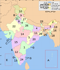
India is composed of 28 states and 7 union territories (including a national capital territory). The union territories are governed by administrators, appointed by the President of India. Two of the territories (Delhi and Pondicherry) have been given partial statehood, with elected legislatures and executive councils of ministers, but limited powers.| Number | State | Code | Capital |
|---|---|---|---|
| 1 | Andhra Pradesh Andhra Pradesh Andhra Pradesh , is one of the 28 states of India, situated on the southeastern coast of India. It is India's fourth largest state by area and fifth largest by population. Its capital and largest city by population is Hyderabad.The total GDP of Andhra Pradesh is $100 billion and is ranked third... |
AP | Hyderabad |
| 2 | Arunachal Pradesh Arunachal Pradesh Arunachal Pradesh is a state of India, located in the far northeast. It borders the states of Assam and Nagaland to the south, and shares international borders with Burma in the east, Bhutan in the west, and the People's Republic of China in the north. The majority of the territory is claimed by... |
AR | Itanagar Itanagar Itanagar is the capital of the Indian state of Arunachal Pradesh. Itanagar is situated at the foothills of Himalayas. It comes administratively under Papum Pare district.... |
| 3 | Assam Assam Assam , also, rarely, Assam Valley and formerly the Assam Province , is a northeastern state of India and is one of the most culturally and geographically distinct regions of the country... |
AS | Dispur |
| 4 | Bihar Bihar Bihar is a state in eastern India. It is the 12th largest state in terms of geographical size at and 3rd largest by population. Almost 58% of Biharis are below the age of 25, which is the highest proportion in India.... |
BR | Patna Patna Paṭnā , is the capital of the Indian state of Bihar and the second largest city in Eastern India . Patna is one of the oldest continuously inhabited places in the world... |
| 5 | Chhattisgarh Chhattisgarh Chhattisgarh is a state in Central India, formed when the 16 Chhattisgarhi-speaking South-Eastern districts of Madhya Pradesh gained separate statehood on 1 November 2000.... |
CG | Raipur |
| 6 | Goa Goa Goa , a former Portuguese colony, is India's smallest state by area and the fourth smallest by population. Located in South West India in the region known as the Konkan, it is bounded by the state of Maharashtra to the north, and by Karnataka to the east and south, while the Arabian Sea forms its... |
GA | Panaji |
| 7 | Gujarat | GJ | Gandhinagar |
| 8 | Haryana Haryana Haryana is a state in India. Historically, it has been a part of the Kuru region in North India. The name Haryana is found mentioned in the 12th century AD by the apabhramsha writer Vibudh Shridhar . It is bordered by Punjab and Himachal Pradesh to the north, and by Rajasthan to the west and south... |
HR | Chandigarh Chandigarh Chandigarh is a union territory of India that serves as the capital of two states, Haryana and Punjab. The name Chandigarh translates as "The Fort of Chandi". The name is from an ancient temple called Chandi Mandir, devoted to the Hindu goddess Chandi, in the city... |
| 9 | Himachal Pradesh Himachal Pradesh Himachal Pradesh is a state in Northern India. It is spread over , and is bordered by the Indian states of Jammu and Kashmir on the north, Punjab on the west and south-west, Haryana and Uttar Pradesh on the south, Uttarakhand on the south-east and by the Tibet Autonomous Region on the east... |
HP | Shimla Shimla Shimla , formerly known as Simla, is the capital city of Himachal Pradesh. In 1864, Shimla was declared the summer capital of the British Raj in India. A popular tourist destination, Shimla is often referred to as the "Queen of Hills," a term coined by the British... |
| 10 | Jammu and Kashmir Jammu and Kashmir Jammu and Kashmir is the northernmost state of India. It is situated mostly in the Himalayan mountains. Jammu and Kashmir shares a border with the states of Himachal Pradesh and Punjab to the south and internationally with the People's Republic of China to the north and east and the... |
JK | Srinagar Srinagar Srinagar is the summer seasonal capital of Jammu and Kashmir. It is situated in Kashmir Valley and lies on the banks of the Jhelum River, a tributary of the Indus. It is one of the largest cities in India not to have a Hindu majority. The city is famous for its gardens, lakes and houseboats... |
| 11 | Jharkhand Jharkhand Jharkhand is a state in eastern India. It was carved out of the southern part of Bihar on 15 November 2000. Jharkhand shares its border with the states of Bihar to the north, Uttar Pradesh and Chhattisgarh to the west, Orissa to the south, and West Bengal to the east... |
JH | Ranchi Ranchi -Climate:Ranchi has a humid subtropical climate. However, due to its position and the forests around the city, it is known for its pleasant climate. Its climate is the primary reason why Ranchi was once the summer capital of the undivided State of Bihar... |
| 12 | Karnataka Karnataka Karnataka , the land of the Kannadigas, is a state in South West India. It was created on 1 November 1956, with the passing of the States Reorganisation Act and this day is annually celebrated as Karnataka Rajyotsava... |
KA | Bangalore Bangalore Bengaluru , formerly called Bengaluru is the capital of the Indian state of Karnataka. Bangalore is nicknamed the Garden City and was once called a pensioner's paradise. Located on the Deccan Plateau in the south-eastern part of Karnataka, Bangalore is India's third most populous city and... |
| 13 | Kerala Kerala or Keralam is an Indian state located on the Malabar coast of south-west India. It was created on 1 November 1956 by the States Reorganisation Act by combining various Malayalam speaking regions.... |
KL | Thiruvananthapuram Thiruvananthapuram Thiruvananthapuram , formerly known as Trivandrum, is the capital of the Indian state of Kerala and the headquarters of the Thiruvananthapuram District. It is located on the west coast of India near the extreme south of the mainland... |
| 14 | Madhya Pradesh Madhya Pradesh Madhya Pradesh , often called the Heart of India, is a state in central India. Its capital is Bhopal and Indore is the largest city.... |
MP | Bhopal |
| 15 | Maharashtra Maharashtra Maharashtra is a state located in India. It is the second most populous after Uttar Pradesh and third largest state by area in India... |
MH | Mumbai Mumbai Mumbai , formerly known as Bombay in English, is the capital of the Indian state of Maharashtra. It is the most populous city in India, and the fourth most populous city in the world, with a total metropolitan area population of approximately 20.5 million... |
| 16 | Manipur Manipur Manipur is a state in northeastern India, with the city of Imphal as its capital. Manipur is bounded by the Indian states of Nagaland to the north, Mizoram to the south and Assam to the west; it also borders Burma to the east. It covers an area of... |
MN | Imphal Imphal Imphal is the capital of the Indian state of Manipur.In the heart of the town and surrounded by a moat, are ruins of the old Palace of Kangla. Kangla Fort used to be the home of the Assam Rifles, a paramilitary force and on November 2004 it was handed over to state of Manipur by Prime minister Dr.... |
| 17 | Meghalaya Meghalaya Meghalaya is a state in north-eastern India. The word "Meghalaya" literally means the Abode of Clouds in Sanskrit and other Indic languages. Meghalaya is a hilly strip in the eastern part of the country about 300 km long and 100 km wide, with a total area of about 8,700 sq mi . The... |
ML | Shillong Shillong -Connectivity:Although well connected by road, Shillong has no rail connection and a proper air connection. Umroi Airport exists but has only limited flights.-Roadways:Shillong is well connected by roads with all major north eastern states... |
| 18 | Mizoram Mizoram Mizoram is one of the Seven Sister States in North Eastern India, sharing borders with the states of Tripura, Assam, Manipur and with the neighbouring countries of Bangladesh and Burma. Mizoram became the 23rd state of India on 20 February 1987. Its capital is Aizawl. Mizoram is located in the... |
MZ | Aizawl Aizawl Aizawl is the capital of the state of Mizoram in India. With a resident population 228,280 , it is the largest city within the state. It is also the center of all important government offices, state assembly house and civil secretariat... |
| 19 | Nagaland Nagaland Nagaland is a state in the far north-eastern part of India. It borders the state of Assam to the west, Arunachal Pradesh and part of Assam to the north, Burma to the east and Manipur to the south. The state capital is Kohima, and the largest city is Dimapur... |
NL | Kohima Kohima Kohima is the hilly capital of India's north eastern border state of Nagaland which shares its borders with Burma. It lies in Kohima District and is also one of the three Nagaland towns with Municipal council status along with Dimapur and Mokokchung.... |
| 20 | Orissa Orissa Orissa , officially Odisha since Nov 2011, is a state of India, located on the east coast of India, by the Bay of Bengal. It is the modern name of the ancient nation of Kalinga, which was invaded by the Maurya Emperor Ashoka in 261 BC. The modern state of Orissa was established on 1 April... |
OR | Bhubaneswar Bhubaneswar Bhubaneswar is the capital of the Indian state of Orissa, officially Odisha. The city has a long history of over 2000 years starting with Chedi dynasty who had Sisupalgarh near present-day Bhubaneswar as their capital... |
| 21 | Punjab Punjab (India) Punjab ) is a state in the northwest of the Republic of India, forming part of the larger Punjab region. The state is bordered by the Indian states of Himachal Pradesh to the east, Haryana to the south and southeast and Rajasthan to the southwest as well as the Pakistani province of Punjab to the... |
PB | Chandigarh Chandigarh Chandigarh is a union territory of India that serves as the capital of two states, Haryana and Punjab. The name Chandigarh translates as "The Fort of Chandi". The name is from an ancient temple called Chandi Mandir, devoted to the Hindu goddess Chandi, in the city... |
| 22 | Rajasthan Rajasthan Rājasthān the land of Rajasthanis, , is the largest state of the Republic of India by area. It is located in the northwest of India. It encompasses most of the area of the large, inhospitable Great Indian Desert , which has an edge paralleling the Sutlej-Indus river valley along its border with... |
RJ | Jaipur Jaipur Jaipur , also popularly known as the Pink City, is the capital and largest city of the Indian state of Rajasthan. Founded on 18 November 1727 by Maharaja Sawai Jai Singh II, the ruler of Amber, the city today has a population of more than 3.1 million.... |
| 23 | Sikkim Sikkim Sikkim is a landlocked Indian state nestled in the Himalayan mountains... |
SK | Gangtok Gangtok Gangtok is the capital and largest town of the Indian state of Sikkim. Gangtok is located in the Shivalik Hills of the eastern Himalayan range, at an altitude of . The town, with a population of thirty thousand belonging to different ethnicities such as Nepalis, Lepchas and Bhutia, is administered... |
| 24 | Tamil Nadu Tamil Nadu Tamil Nadu is one of the 28 states of India. Its capital and largest city is Chennai. Tamil Nadu lies in the southernmost part of the Indian Peninsula and is bordered by the union territory of Pondicherry, and the states of Kerala, Karnataka, and Andhra Pradesh... |
TN | Chennai Chennai Chennai , formerly known as Madras or Madarasapatinam , is the capital city of the Indian state of Tamil Nadu, located on the Coromandel Coast off the Bay of Bengal. Chennai is the fourth most populous metropolitan area and the sixth most populous city in India... |
| 25 | Tripura Tripura Tripura is a state in North-East India, with an area of . It is the third smallest state of India, according to area. Tripura is surrounded by Bangladesh on the north, south, and west. The Indian states of Assam and Mizoram lie to the east. The capital is Agartala and the main languages spoken are... |
TR | Agartala |
| 26 | Uttar Pradesh Uttar Pradesh Uttar Pradesh abbreviation U.P. , is a state located in the northern part of India. With a population of over 200 million people, it is India's most populous state, as well as the world's most populous sub-national entity... |
UP | Lucknow Lucknow Lucknow is the capital city of Uttar Pradesh in India. Lucknow is the administrative headquarters of Lucknow District and Lucknow Division.... |
| 27 | Uttarakhand Uttarakhand Uttarakhand , formerly Uttaranchal, is a state in the northern part of India. It is often referred to as the Land of Gods due to the many holy Hindu temples and cities found throughout the state, some of which are among Hinduism's most spiritual and auspicious places of pilgrimage and worship... |
UK | Dehradun Dehradun - Geography :The Dehradun district has various types of physical geography from Himalayan mountains to Plains. Raiwala is the lowest point at 315 meters above sea level, and the highest points are within the Tiuni hills, rising to 3700 m above sea level... |
| 28 | West Bengal West Bengal West Bengal is a state in the eastern region of India and is the nation's fourth-most populous. It is also the seventh-most populous sub-national entity in the world, with over 91 million inhabitants. A major agricultural producer, West Bengal is the sixth-largest contributor to India's GDP... |
WB | Kolkata Kolkata Kolkata , formerly known as Calcutta, is the capital of the Indian state of West Bengal. Located on the east bank of the Hooghly River, it was the commercial capital of East India... |
Union territories
| Number | Union territory | Code | Capital |
|---|---|---|---|
| A | Andaman and Nicobar Islands | AN | Port Blair Port Blair Port Blair is the largest town and a municipal council in Andaman district in the Andaman Islands and the capital of the Andaman and Nicobar Islands, a union territory of India... |
| B | Chandigarh Chandigarh Chandigarh is a union territory of India that serves as the capital of two states, Haryana and Punjab. The name Chandigarh translates as "The Fort of Chandi". The name is from an ancient temple called Chandi Mandir, devoted to the Hindu goddess Chandi, in the city... |
CH | Chandigarh |
| C | Dadra and Nagar Haveli | DN | Silvassa Silvassa Silvassa is the capital of the Indian Union Territory of Dadra and Nagar Haveli.The city has a large number of factories and industries providing significant government revenue, which allows the city to maintain a low level of taxation.-Geography:Silvassa is located at... |
| D | Daman and Diu | DD | Daman |
| E | Lakshadweep Lakshadweep Lakshadweep , formerly known as the Laccadive, Minicoy, and Amindivi Islands, is a group of islands in the Laccadive Sea, 200 to 440 km off the coast of the South West Indian state of Kerala... |
LD | Kavaratti Kavaratti Kavaratti is a census town in the Indian Union Territory and the capital of Lakshadweep. Kavaratti is also the name of the island upon which the town stands.-Geography:... |
| F | National Capital Territory Delhi Delhi , officially National Capital Territory of Delhi , is the largest metropolis by area and the second-largest by population in India, next to Mumbai. It is the eighth largest metropolis in the world by population with 16,753,265 inhabitants in the Territory at the 2011 Census... |
ND | New Delhi New Delhi New Delhi is the capital city of India. It serves as the centre of the Government of India and the Government of the National Capital Territory of Delhi. New Delhi is situated within the metropolis of Delhi. It is one of the nine districts of Delhi Union Territory. The total area of the city is... |
| G | Pondicherry | PY | Pondicherry |
- See also:
- List of states and union territories of India by population (area can also be found)
- Official languages of India#Languages currently used In Indian states and union territories
Regions
Some of the states of India are divided into regions. The Regions of India are not official administrative divisions. They have no official administrative governmental status. They are purely geographic regions; some correspond to historic countries, states or provinces. A region may comprise one or more divisions, averaging about three divisions per region. However, the boundaries of the regions and the boundaries of the divisions do not always coincide exactly. So far there has been no movement to give the regions official administrative status. If this was to be done, it would presumably require that the boundaries of the regions be slightly modified so that they correspond exactly with their constituent districts.- Regions of GujaratRegions of GujaratRegions of Gujarat are based on geographic location & their climate.The regions share nearly same culture heritage & dialect.Kutch* Geographic location - north-west in Gujarat* Climate - Dry & semi desertic...
- Regions of Kerala
- Regions of Maharashtra
- Regions of Uttar Pradesh
Divisions
Some of the Indian states are subdivided into divisions, each comprising several districts:- Divisions of Andhra PradeshDistricts of Andhra PradeshThe state of Andhra Pradesh is divided into 23 districts which are listed below....
- Divisions of Arunachal PradeshDivisions of Arunachal PradeshThe state of Arunachal Pradesh is divided into 16 divisions/districts which are listed below:#Anjaw District#Changlang District#East Kameng#East Siang#Kurung Kumey#Lohit District#Lower Dibang Valley#Lower Subansiri#Papum Pare#Tawang District#Tirap District...
- Divisions of Assam
- Divisions of BiharDivisions of BiharThe state of Bihar in India is divided into 9 divisions as follows:- Patna Division:*Headquarters: Patna*Number of Districts : 6*Name of Districts : Patna District; Nalanda District, also called Biharsharif District; Bhojpur District, also called Arrah District; Rohtas District, also called...
- Divisions of Chhattisgarh
- Divisions of Goa
- Divisions of Gujarat
- Divisions of HaryanaDivisions of HaryanaHaryana a state in northern India was formed on November 1, 1966. The state is divided into 4 divisions.* Ambala Division* Gurgaon Division* Hisar Division* Rohtak Division...
- Divisions of Himachal Pradesh
- Divisions of Jammu and Kashmir
- Divisions of JharkhandDivisions of JharkhandJharkhand, one of the states of India, is divided into 5 divisions.* Kolhan division* North Chotanagpur division* Palamu division* Santhal Pargana division* South Chotanagpur division...
- Divisions of KarnatakaDivisions of KarnatakaKarnataka a state in southern India was formed on November 1, 1973. The state is divided into 4 divisions.* Bangalore Division* Belgaum Division* Gulbarga Division* Mysore Division-References and Additional Resources:**...
- Divisions of KeralaDivisions of KeralaThe Indian state of Kerala borders with the states of Tamil Nadu on the south and east, Karnataka on the north and the Arabian Sea coastline on the west...
- Divisions of Madhya Pradesh
- Divisions of Maharashtra
- Divisions of Manipur
- Divisions of Meghalaya
- Divisions of Mizoram
- Divisions of Nagaland
- Divisions of Orissa
- Divisions of Punjab (India)
- Divisions of RajasthanDivisions of RajasthanRajasthan has seven divisions.-Ajmer Division:The division comprises four districts, namely, Ajmer, Bhilwara, Nagaur, Tonk.-Bharatpur Division:The division comprises four districts, namely, Bharatpur, Dholpur, Karauli, Sawai Madhopur.-Bikaner Division:...
- Divisions of Sikkim
- Divisions of Tamil Nadu
- Divisions of Tripura
- Divisions of Uttar PradeshDivisions of Uttar PradeshThe Indian state of Uttar Pradesh borders with Nepal and the Indian states of Bihar, Jharkhand, Chhattisgarh, Madhya Pradesh, Rajasthan, Haryana, Uttarakhand and National Capital Territory of Delhi. The Himalayas lies in the north of the state and the Deccan Plateau is at the south...
- Divisions of Uttarakhand
- Divisions of West BengalDivisions of West BengalThe Indian state of Paschimbanga is divided into three administrative Divisions, namely:* Jalpaiguri division* Burdwan division* Presidency division...
- Divisions of Delhi
Districts
States and territories (or divisions) are further subdivided into DistrictsDistricts of India
A district is an administrative division of an Indian state or territory. Districts are further subdivided, in some cases into Sub-Divisions, and otherwise directly into tehsils or talukas.District officials include:...
(zilla), of which there are 640.
Sub-Districts
TehsilTehsil
A Tehsil or Tahsil/Tahasil , also known as Taluk and Mandal, is an administrative division of some country/countries of South Asia....
s, talukas, blocks or mandals (sub-districts), headed by a Tehsildar or Talukdar, comprise several villages or village clusters. The governmental bodies at the Tehsil level are called the panchayat samiti
Panchayat samiti
Panchayat samiti is a local government body at the tehsil or Taluka level in India. It works for the villages of the Tehsil or Taluka that together are called a Development Block. The Panchayat Samiti is the link between the Gram Panchayat and the district administration. There are a number of...
.
States use varying names for their sub-districts. Detailed information is as follows:
| State or U.T. | Name for sub-district | Number of sub-districts |
| Jammu and Kashmir Jammu and Kashmir Jammu and Kashmir is the northernmost state of India. It is situated mostly in the Himalayan mountains. Jammu and Kashmir shares a border with the states of Himachal Pradesh and Punjab to the south and internationally with the People's Republic of China to the north and east and the... |
Tahsil | 59 |
| Himachal Pradesh Himachal Pradesh Himachal Pradesh is a state in Northern India. It is spread over , and is bordered by the Indian states of Jammu and Kashmir on the north, Punjab on the west and south-west, Haryana and Uttar Pradesh on the south, Uttarakhand on the south-east and by the Tibet Autonomous Region on the east... |
Tahsil/Sub-Tahsil | 109 |
| Punjab | Tahsil | 72 |
| Chandigarh Chandigarh Chandigarh is a union territory of India that serves as the capital of two states, Haryana and Punjab. The name Chandigarh translates as "The Fort of Chandi". The name is from an ancient temple called Chandi Mandir, devoted to the Hindu goddess Chandi, in the city... |
Tahsil | 1 |
| Uttaranchal | Tahsil | 49 |
| Haryana Haryana Haryana is a state in India. Historically, it has been a part of the Kuru region in North India. The name Haryana is found mentioned in the 12th century AD by the apabhramsha writer Vibudh Shridhar . It is bordered by Punjab and Himachal Pradesh to the north, and by Rajasthan to the west and south... |
Tahsil | 67 |
| Delhi Delhi Delhi , officially National Capital Territory of Delhi , is the largest metropolis by area and the second-largest by population in India, next to Mumbai. It is the eighth largest metropolis in the world by population with 16,753,265 inhabitants in the Territory at the 2011 Census... |
Tahsil | 27 |
| Rajasthan Rajasthan Rājasthān the land of Rajasthanis, , is the largest state of the Republic of India by area. It is located in the northwest of India. It encompasses most of the area of the large, inhospitable Great Indian Desert , which has an edge paralleling the Sutlej-Indus river valley along its border with... |
Tahsil | 241 |
| Uttar Pradesh Uttar Pradesh Uttar Pradesh abbreviation U.P. , is a state located in the northern part of India. With a population of over 200 million people, it is India's most populous state, as well as the world's most populous sub-national entity... |
Tahsil | 300 |
| Bihar Bihar Bihar is a state in eastern India. It is the 12th largest state in terms of geographical size at and 3rd largest by population. Almost 58% of Biharis are below the age of 25, which is the highest proportion in India.... |
C.D.Block | 533 |
| Sikkim Sikkim Sikkim is a landlocked Indian state nestled in the Himalayan mountains... |
Sub-Division | 9 |
| Arunachal Pradesh Arunachal Pradesh Arunachal Pradesh is a state of India, located in the far northeast. It borders the states of Assam and Nagaland to the south, and shares international borders with Burma in the east, Bhutan in the west, and the People's Republic of China in the north. The majority of the territory is claimed by... |
Circle | 149 |
| Nagaland Nagaland Nagaland is a state in the far north-eastern part of India. It borders the state of Assam to the west, Arunachal Pradesh and part of Assam to the north, Burma to the east and Manipur to the south. The state capital is Kohima, and the largest city is Dimapur... |
Circle | 93 |
| Manipur Manipur Manipur is a state in northeastern India, with the city of Imphal as its capital. Manipur is bounded by the Indian states of Nagaland to the north, Mizoram to the south and Assam to the west; it also borders Burma to the east. It covers an area of... |
Sub-Division | 38 |
| Mizoram Mizoram Mizoram is one of the Seven Sister States in North Eastern India, sharing borders with the states of Tripura, Assam, Manipur and with the neighbouring countries of Bangladesh and Burma. Mizoram became the 23rd state of India on 20 February 1987. Its capital is Aizawl. Mizoram is located in the... |
R.D.Block | 22 |
| Tripura Tripura Tripura is a state in North-East India, with an area of . It is the third smallest state of India, according to area. Tripura is surrounded by Bangladesh on the north, south, and west. The Indian states of Assam and Mizoram lie to the east. The capital is Agartala and the main languages spoken are... |
C.D.Block | 38 |
| Meghalaya Meghalaya Meghalaya is a state in north-eastern India. The word "Meghalaya" literally means the Abode of Clouds in Sanskrit and other Indic languages. Meghalaya is a hilly strip in the eastern part of the country about 300 km long and 100 km wide, with a total area of about 8,700 sq mi . The... |
C.D.Block | 32 |
| Assam Assam Assam , also, rarely, Assam Valley and formerly the Assam Province , is a northeastern state of India and is one of the most culturally and geographically distinct regions of the country... |
Circle | 155 |
| West Bengal West Bengal West Bengal is a state in the eastern region of India and is the nation's fourth-most populous. It is also the seventh-most populous sub-national entity in the world, with over 91 million inhabitants. A major agricultural producer, West Bengal is the sixth-largest contributor to India's GDP... |
C.D.Block | 341 |
| Jharkhand Jharkhand Jharkhand is a state in eastern India. It was carved out of the southern part of Bihar on 15 November 2000. Jharkhand shares its border with the states of Bihar to the north, Uttar Pradesh and Chhattisgarh to the west, Orissa to the south, and West Bengal to the east... |
C.D.Block | 210 |
| Orissa Orissa Orissa , officially Odisha since Nov 2011, is a state of India, located on the east coast of India, by the Bay of Bengal. It is the modern name of the ancient nation of Kalinga, which was invaded by the Maurya Emperor Ashoka in 261 BC. The modern state of Orissa was established on 1 April... |
Police Station | 485 |
| Chhatisgarh | Tahsil | 97 |
| Madhya Pradesh Madhya Pradesh Madhya Pradesh , often called the Heart of India, is a state in central India. Its capital is Bhopal and Indore is the largest city.... |
Tahsil | 259 |
| Gujarat | Taluk | 226 |
| Daman & Diu | Taluk | 2 |
| Dadra & Nagar Haveli | Taluk | 1 |
| Maharashtra Maharashtra Maharashtra is a state located in India. It is the second most populous after Uttar Pradesh and third largest state by area in India... |
Tahsil | 353 |
| Andhra Pradesh Andhra Pradesh Andhra Pradesh , is one of the 28 states of India, situated on the southeastern coast of India. It is India's fourth largest state by area and fifth largest by population. Its capital and largest city by population is Hyderabad.The total GDP of Andhra Pradesh is $100 billion and is ranked third... |
Mandal | 1125 |
| Karnataka Karnataka Karnataka , the land of the Kannadigas, is a state in South West India. It was created on 1 November 1956, with the passing of the States Reorganisation Act and this day is annually celebrated as Karnataka Rajyotsava... |
Taluk | 175 |
| Goa Goa Goa , a former Portuguese colony, is India's smallest state by area and the fourth smallest by population. Located in South West India in the region known as the Konkan, it is bounded by the state of Maharashtra to the north, and by Karnataka to the east and south, while the Arabian Sea forms its... |
Taluk | 11 |
| Lakshadweep Lakshadweep Lakshadweep , formerly known as the Laccadive, Minicoy, and Amindivi Islands, is a group of islands in the Laccadive Sea, 200 to 440 km off the coast of the South West Indian state of Kerala... |
Sub-Division | 4 |
| Kerala Kerala or Keralam is an Indian state located on the Malabar coast of south-west India. It was created on 1 November 1956 by the States Reorganisation Act by combining various Malayalam speaking regions.... |
Taluk | 63 |
| Tamil Nadu Tamil Nadu Tamil Nadu is one of the 28 states of India. Its capital and largest city is Chennai. Tamil Nadu lies in the southernmost part of the Indian Peninsula and is bordered by the union territory of Pondicherry, and the states of Kerala, Karnataka, and Andhra Pradesh... |
Taluk | 201 |
| Pondicherry | Commune Panchayat | 10 |
| Andaman & Nicobar Islands | Tahsil | 7 |
Blocks
The block is often the next level of administrative division after the tehsil.Hoblis
A hobliHobli
A hobli is defined as a cluster of adjoining villages in the state of Karnataka, India. This clustering of villages was formed mainly to streamline the collection of taxes and maintenance of land records by the revenue department of the state. Each hobli consists of several villages and several...
is a subdivision of a taluka which groups adjoining villages in the state of Karnataka
Karnataka
Karnataka , the land of the Kannadigas, is a state in South West India. It was created on 1 November 1956, with the passing of the States Reorganisation Act and this day is annually celebrated as Karnataka Rajyotsava...
. They may have been made for administrative purposes by the revenue department of the state.
Villages
Villages are often the lowest level of subdivisions in India. The governmental bodies at the village level are called Gram PanchayatGram panchayat
Gram panchayats are local self-governments at the village or small town level in India. As of 2002 there were about 265,000 gram panchayats in India. The gram panchayat is the foundation of the Panchayat System. A gram panchayat can be set up in villages with minimum population of 300...
, of which there were an estimated 256,000 in 2002.
Each Gram Panchayat covers a large village or a cluster of smaller villages with a combined population exceeding 500 (Gram Group). Clusters of villages are also sometimes called Hobli
Hobli
A hobli is defined as a cluster of adjoining villages in the state of Karnataka, India. This clustering of villages was formed mainly to streamline the collection of taxes and maintenance of land records by the revenue department of the state. Each hobli consists of several villages and several...
.
Habitations
Certain governmental functions and activities - including clean water availability, rural development, and education - are tracked at a sub-village level. These hamlets are termed "habitations". India is composed of approximately 1.6 million habitations. In some states, most villages have a single habitation; in others (notably KeralaKerala
or Keralam is an Indian state located on the Malabar coast of south-west India. It was created on 1 November 1956 by the States Reorganisation Act by combining various Malayalam speaking regions....
and Tripura
Tripura
Tripura is a state in North-East India, with an area of . It is the third smallest state of India, according to area. Tripura is surrounded by Bangladesh on the north, south, and west. The Indian states of Assam and Mizoram lie to the east. The capital is Agartala and the main languages spoken are...
) there is a high ratio of habitations to villages.
Municipalities
Municipalities of India are governed by Municipal CorporationMunicipal corporation
A municipal corporation is the legal term for a local governing body, including cities, counties, towns, townships, charter townships, villages, and boroughs. Municipal incorporation occurs when such municipalities become self-governing entities under the laws of the state or province in which...
s (Mahanagar Paalika) for large urban areas, Municipal Council
Municipal council
A municipal council is the local government of a municipality. Specifically the term can refer to the institutions of various countries that can be translated by this term...
(Nagar Paalika) for smaller urban areas, and Town Councils (Nagar Panchayat
Nagar Panchayat
A nagar palika or nagar panchayat is a form of an urban political unit in India comparable to a municipality.An urban centre with more than 30,000 and less than 100,000 inhabitants is classified as a nagar panchayat....
s) for suburban areas. Municipalities can be as large as a district or smaller than a Tehsil.