

Divisions of West Bengal
Encyclopedia
India
India , officially the Republic of India , is a country in South Asia. It is the seventh-largest country by geographical area, the second-most populous country with over 1.2 billion people, and the most populous democracy in the world...
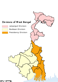
n state of Paschimbanga is divided into three administrative Divisions, namely:
- Jalpaiguri divisionJalpaiguri divisionJalpaiguri Division is a division in the Indian state of West Bengal. It consists of 6 districts:* Jalpaiguri district* Darjeeling district* Cooch Behar district* Malda district* North Dinajpur district...
- Burdwan divisionBurdwan DivisionBurdwan Division is a division in the Indian state of West Bengal. It consists of 7 districts:* Bankura district* Bardhaman district* Birbhum district* East Midnapore * Hooghly district* Purulia district...
- Presidency divisionPresidency divisionPresidency Division is a division in the Indian state of West Bengal. It consists of 6 districts:* Howrah district* Kolkata district* Murshidabad district* Nadia district* North 24 Parganas district* South 24 Parganas district-References:...
A group of districts forms a division, which is administered by a 'Divisional Commissioner'. Paschimbanga is now divided in nineteen districts, grouped under three divisions:
| Burdwan division Burdwan Division Burdwan Division is a division in the Indian state of West Bengal. It consists of 7 districts:* Bankura district* Bardhaman district* Birbhum district* East Midnapore * Hooghly district* Purulia district... |
Jalpaiguri division Jalpaiguri division Jalpaiguri Division is a division in the Indian state of West Bengal. It consists of 6 districts:* Jalpaiguri district* Darjeeling district* Cooch Behar district* Malda district* North Dinajpur district... |
Presidency division Presidency division Presidency Division is a division in the Indian state of West Bengal. It consists of 6 districts:* Howrah district* Kolkata district* Murshidabad district* Nadia district* North 24 Parganas district* South 24 Parganas district-References:... |
|---|---|---|
|
Cooch Behar District Cooch Behar district is a district of the state of West Bengal, India, as well as the district's namesake town. During the British Raj, the town of Cooch Behar was the seat of a princely state of Koch Bihar, ruled by the Koch dynasty.... Darjeeling district Darjeeling District is the northernmost district of the state of West Bengal in eastern India in the foothills of the Himalayas. The district is famous for its beautiful hill stations and Darjeeling tea. Darjeeling is the district headquarters... Jalpaiguri District Jalpaiguri district is the largest district of North Bengal, covering an area 6,245 km2. It is situated between 26° 16' and 27° 0' North latitudes and 88° 4' and 89° 53' East longitudes... Malda district Malda district is a district of West Bengal, India. It lies 347 km north of Kolkata, the state capital. Mango and silk are notable products of this district. The special variety of mango produced in this region, popularly known by the name of the district, is exported across the world and... |
Howrah District Howrah district is a district of the West Bengal state in eastern India. It has thousands of years of rich heritage in the form of the great Bengali kingdom of Bhurshut. The district is named after its headquarters, the city of Howrah.-Geography:... Kolkata District Kolkata district is an administrative district of the Indian state of West Bengal. It contains the center part of the city of Kolkata. The jurisdiction of the Kolkata... Murshidabad district Murshidabad district is a district of West Bengal in eastern India. Situated on the left bank of the river Ganges, the district is very fertile. Covering an area of 5,341 km² and having a population 5.863m it is a densely populated district and the ninth most populous in India... Nadia District Nadia district is a district of the state of West Bengal, in the north east of India. It borders with Bangladesh to the east, North 24 Parganas and Hooghly districts to the south, Bardhaman district to the west, and Murshidabad district to the north.... North 24 Parganas district North 24 Parganas district is a district in southern West Bengal, of eastern India. North 24 Parganas extends in the [tropical zone] from latitude 22º11'6" north to 23º15'2" north and from longitude 88º20' east to 89º5' east... (Uttar 24 Parganas) South 24 Parganas district South 24 Parganas district is an important district of West Bengal State with its district headquarters in Alipore. It has the urban fringe of Calcutta on one side and the remote riverine villages in the Sundarbans.... (Dakshin 24 Parganas) |