

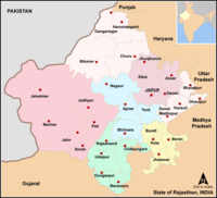
Divisions of Rajasthan
Encyclopedia
Rajasthan
Rājasthān the land of Rajasthanis, , is the largest state of the Republic of India by area. It is located in the northwest of India. It encompasses most of the area of the large, inhospitable Great Indian Desert , which has an edge paralleling the Sutlej-Indus river valley along its border with...
has seven divisions.
Ajmer DivisionAjmer DivisionAjmer Division is one of the administrative geographical unit, called a division, of Rajasthan state, India. The division comprises four districts: Ajmer, Bhilwara, Nagaur, Tonk....
The division comprises four districts, namely, AjmerAjmer district
Ajmer District is a district of the state of Rajasthan in western India. The city of Ajmer is the district headquarters.Ajmer District has an area of 8,481 km², and a population of 2,180,526 ,Three main groups are; Hindu 1,869,044, Muslim 244,341, Jains 47,812...
, Bhilwara
Bhilwara district
Bhilwara District is a district of the state of Rajasthan in western India. The town of Bhilwara is the district headquarters.-Geography and demographics:...
, Nagaur
Nagaur District
Nagaur District is one of the 33 districts of the state of Rajasthan in western India.Area of the district is 17,718 km2. The city of Nagaur is the district headquarters.- Geography :...
, Tonk
Tonk District
Tonk District is a district of the state of Rajasthan in western India. The city of Tonk is the administrative headquarters of the district. The district is bounded on the north by Jaipur district, on the east by Sawai Madhopur district, on the southeast by Kota district, on the south by Bundi...
.
Bharatpur DivisionBharatpur DivisionBharatpur Division is one of the administrative geographical unit, called a division, of Rajasthan state, India. The division comprises four districts, namely, Bharatpur, Dholpur, Karauli, Sawai Madhopur....
The division comprises four districts, namely, BharatpurBharatpur district
Bharatpur District is a district of Rajasthan state in western India. The town of Bharatpur is the district headquarters.-History:When Bharatpur was a princely state, it was the only political entity ever to have a Chartreuse colored flag.-Demographics:...
, Dholpur
Dholpur district
Dholpur District is a district of Rajasthan state in western India. The town of Dholpur is the district headquarters.Dholpur District has an area of 3084 km². The Chambal River forms the southern boundary of the district, across which lies the state of Madhya Pradesh...
, Karauli
Karauli district
Karauli District is a district of Rajasthan state in western India. The town of Karauli is the district headquarters. The district of Karauli encompasses an area of 5530 km². It is bordered by Dholpur District to the east; by Bharatpur District to the north-east; by Dausa District to the...
, Sawai Madhopur
Sawai Madhopur district
Sawai Madhopur District is a district of Rajasthan state in western India. Sawai Madhopur is the chief town and district headquarters. The district has an area of 4500 km², and a population of 1,116,031 with a population density of 248 persons per km²...
.
Bikaner DivisionBikaner DivisionBikaner Division is one of the administrative geographical unit, called a division, of Rajasthan state, India. The division comprises four districts, namely, Bikaner, Churu, Sri Ganganagar, Hanumangarh....
The division comprises four districts, namely, BikanerBikaner district
Bikaner District is a district of the state of Rajasthan in western India. The historic city of Bikaner is the district headquarters. Bikaner is also Division with the four district: Bikaner, Churu, Sri Ganganagar and Hanumangarh.-Geography:...
, Churu
Churu district
Churu is a district of Rajasthan state of western India. The town of Churu is the administrative headquarters of the district.Churu lies in the Jangladesh region of northern Rajasthan...
, Sri Ganganagar, Hanumangarh
Hanumangarh district
Hanumangarh District is a district of Rajasthan state of western India. The town of Hanumangarh is the district headquarters.-District profile:...
.
Jaipur DivisionJaipur DivisionJaipur Division is one of the administrative geographical unit, called a division, of Rajasthan state, India. The division comprises five districts, namely, Alwar, Dausa, Jaipur, Jhunjhunu, Sikar....
The division comprises five districts, namely, AlwarAlwar District
Alwar District is a district in Rajasthan, a state in northern India, with capital in the city of Alwar.The district is bounded on the north by Haryana state, and on the east by Bharatpur, on the south by Dausa, and on the west by Jaipur districts....
, Dausa
Dausa district
Dausa District is a district of Rajasthan state in western India. The city of Dausa is the district headquarters. Dausa District has a population of 1,316,790 , an area of 2950 km², and a population density of 384 persons per km² with 62.75 % literacy rate...
, Jaipur
Jaipur district
Jaipur District is a district of the state of Rajasthan in western India. The city of Jaipur, which is Rajasthan's capital and largest city, is the district headquarters. It is the tenth most populous district in India .-Geography:...
, Jhunjhunu
Jhunjhunu District
Jhunjhunu district or Jhunjhunun district is a district of the state of Rajasthan in western India. The town of Jhunjhunu is the district headquarters....
, Sikar
Sikar district
Sikar District is a district of the state of Rajasthan in western India. The town of Sikar is the district headquarters.-Location:The district is located in the north-eastern part of the state of Rajasthan. It is bounded on the north by Jhunjhunu District, in the north-west by Churu district, in...
.
Jodhpur DivisionJodhpur DivisionJodhpur Division is one of the administrative geographical unit, called a division, of Rajasthan state, India. The division comprises six districts, namely, Barmer, Jaisalmer, Jalore, Jodhpur, Pali, Sirohi....
The division comprises six districts, namely, BarmerBarmer district
Barmer is a district of Rajasthan state, India. Barmer is the district headquarters. Balotra, Guda Malani, Baytoo, Siwana, Jasol and Chohatan are other major towns.-Geography:...
, Jaisalmer
Jaisalmer district
Jaisalmer District is a district of Rajasthan state in western India. The city of Jaisalmer is the administrative headquarters of the district.As of 2011 it is the least populous district of Rajasthan .-Geography:...
, Jalore, Jodhpur
Jodhpur district
Jodhpur District is a district of the state of Rajasthan in western India. The city of Jodhpur is the administrative headquarters of the district.As of 2011 it is the second most populous district of Rajasthan , after Jaipur.-History:...
, Pali
Pali district
Pali District is a district of the state of Rajasthan in western India. The town of Pali is the district headquarters.-History:...
, Sirohi
Sirohi district
Sirohi District is a district of Rajasthan state in western India. The town of Sirohi is the district headquarters.As of 2011 it is the third least populous district of Rajasthan , after Jaisalmer and Pratapgarh.-Demographics:...
.
Kota DivisionKota DivisionKota Division is one of the administrative geographical unit, called a division, of Rajasthan state, India. The division comprises four districts, namely, Baran, Bundi, Jhalawar, Kota....
The division comprises four districts, namely, BaranBaran district
Baran District is a district of the state of Rajasthan in western India. The town of Baran is the district headquarters.The district has an area of 6955.4 km², and a population of 1,021,653...
, Bundi
Bundi district
Bundi District is a district of the state of Rajasthan in western India. The town of Bundi is the district headquarters. It has an area of 5,550 km² and a population of 88,273...
, Jhalawar
Jhalawar district
Jhalawar district is one of the 33 districts of Rajasthan state in western India. The district is bounded on the northwest by Kota district, on the northeast by Baran district, on the east by Guna district of Madhya Pradesh state, on the south by Rajgarh and Shajapur districts of Madhya Pradesh...
, Kota
Kota district
Kota District is a district of the state of Rajasthan in western India. The city of Kota is the administrative headquarters of the district.During the period around 12th century AD, Rao Deva,a Hada Chieftain conquered the territory and founded Bundi and Hadoti...
.
Udaipur DivisionUdaipur DivisionUdaipur Division is one of the administrative geographical unit, called a division, of Rajasthan state, India. The division comprises six districts, namely, Banswara, Chittorgarh, Dungarpur, Rajsamand, Udaipur and Pratapgarh, Rajasthan....
The division comprises six districts, namely, BanswaraBanswara district
Banswara District has an area of 5,037 km², 1.47% of Rajasthan state, India. The city of Banswara is the district headquarters. It is bounded on the north by Udaipur District, on the northeast by Chittorgarh District, on the east and southeast by Madhya Pradesh state, on the southwest by...
, Chittorgarh
Chittorgarh district
Chittorgarh District is a district of Rajasthan state in western India. The historic city of Chittorgarh is the administrative headquarters of the district....
, Dungarpur
Dungarpur district
Dungarpur District is a district of the state of Rajasthan in western India. The town of Dungarpur is the district headquarters.-Geography:Dungarpur lies in 23° 8' N latitude and 73° 7' E longitude. The district has an area of 3,770 km². The district is roughly triangular in shape...
, Rajsamand, Pratapgarh
Pratapgarh district (Rajasthan)
Pratapgarh district is the 33rd district of Rajasthan, created on 26 January 2008. It is a part of Udaipur Division and has been carved out from the erstwhile tehsils of Chittorgarh, Udaipur and Banswara districts...
, Udaipur
Udaipur district
Udaipur District is one of the 33 districts of Rajasthan state in western India. The historic city of Udaipur is the administrative headquarters of the district....
.
Pratapgarh