
St George, New South Wales
Encyclopedia
St George Area is an unofficial name applied to a group of southern suburbs
in Sydney
, in the state of New South Wales
, Australia
. The area includes all the suburbs in the local government areas of the City of Hurstville
, the City of Rockdale
and the Municipality of Kogarah
. The eastern boundary of the district is Lady Robinson Beach
on Botany Bay
.
, the Eora
tribe inhabited land from Port Jackson
to Botany Bay
and the Georges River
. There is evidence to suggest that these people belonged to the Gweagal
, Bidjigal
and Cadigal
clans.
 James Cook
sailed the HMS Endeavour
into Botany Bay
in 1770 for his first landing on the continent of Australia
. Captain Arthur Phillip
led the First Fleet
into the bay on 18 January 1788 to found a penal colony
there but found the sandy infertile soil disappointing and moved the site of the settlement north to the natural harbor of Port Jackson
.
The ridge between the Cooks River
and Georges River
was covered in a dense forest which first attracted timber cutters to the area. Wood gatherers, bark collectors, sawyers and charcoal burners moved into the area to work the forests of Simeon Lord
and supply Sydney’s timber needs. By the 1840s, Major Mitchell was building the Illawarra Road (now Forest Road) on the ridge through ‘Lord’s Bush’, which required enormous amounts of trees and bush to be cleared. Irishman Michael Gannon was innkeeper at Cooks River in the 1840s. He acquired land in the area, part of which became known as ‘Gannons Forest’ which later was the centre of Hurstville
. By 1851 it was estimated that 50 to 100 carts of timber and lime crossed the Cooks River daily.
St George Parish was one of the original parishes within Cumberland County
. There were eight other parishes named after saints; but St George and St James are the only ones which are widely known today. A map of the parish revealed that the land was cup into areas ranging from 30 to 500 acres (2 km²) and a few large land grants of 2000 acres (8.1 km²). The recipients were William Packer, Josh Thorp, James Oatley, Hannah Laycock, F. W. Unwin, Reuben and David Hannam, Patrick Moore, J. Beehag, John Porter and the larger grants were James Chandler and John and Robert Townson.
The regional identity was reinforced by the creation in 1949 of a federal electorate, the Division of St George
, in the area. The Division was abolished in 1993. The area's identity is maintained mostly through the St George Illawarra Dragons
who play in the National Rugby League
, and the St. George Bank
.
, Kogarah
and Rockdale
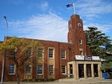
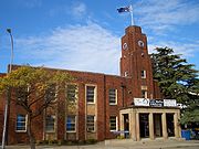
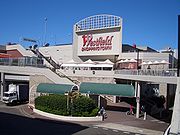
. Hurstville is the largest central business district
in southern Sydney and features a large shopping centre
called Westfield Hurstville
.
Southern Sydney
This article refers to an area the same as a combination of St George and SutherlandSouthern Sydney is a general term which is used to describe the southern metropolitan area of Sydney, in the state of New South Wales, Australia....
in Sydney
Sydney
Sydney is the most populous city in Australia and the state capital of New South Wales. Sydney is located on Australia's south-east coast of the Tasman Sea. As of June 2010, the greater metropolitan area had an approximate population of 4.6 million people...
, in the state of New South Wales
New South Wales
New South Wales is a state of :Australia, located in the east of the country. It is bordered by Queensland, Victoria and South Australia to the north, south and west respectively. To the east, the state is bordered by the Tasman Sea, which forms part of the Pacific Ocean. New South Wales...
, Australia
Australia
Australia , officially the Commonwealth of Australia, is a country in the Southern Hemisphere comprising the mainland of the Australian continent, the island of Tasmania, and numerous smaller islands in the Indian and Pacific Oceans. It is the world's sixth-largest country by total area...
. The area includes all the suburbs in the local government areas of the City of Hurstville
City of Hurstville
The City of Hurstville is a Local Government Area in southern Sydney, in the state of New South Wales, Australia. The city centre is located 17km SSW of the Sydney central business district and west of Botany Bay....
, the City of Rockdale
City of Rockdale
The City of Rockdale is a Local Government Area in southern Sydney, in the state of New South Wales, Australia. The city centre is located 12 kilometres south-south-west of the Sydney central business district, on the western shores of Botany Bay...
and the Municipality of Kogarah
Municipality of Kogarah
The Municipality of Kogarah is a Local Government Area in southern Sydney, in the state of New South Wales, Australia. The centre of the municipality is located 14km SSW of the Sydney central business district and west of Botany Bay....
. The eastern boundary of the district is Lady Robinson Beach
Lady Robinson Beach
Lady Robinsons Beach is the stretch of beach between the mouth of the Cooks River and the mouth of Georges River on the western shore of Botany Bay. Originally the beach was known as Seven Mile Beach. The beach was renamed after the wife of the then Governor, Sir Hercules Robinson...
on Botany Bay
Botany Bay
Botany Bay is a bay in Sydney, New South Wales, a few kilometres south of the Sydney central business district. The Cooks River and the Georges River are the two major tributaries that flow into the bay...
.
Aborigines
The first inhabitants of the St George area were Australian Aborigines. At the time of the arrival of the First FleetFirst Fleet
The First Fleet is the name given to the eleven ships which sailed from Great Britain on 13 May 1787 with about 1,487 people, including 778 convicts , to establish the first European colony in Australia, in the region which Captain Cook had named New South Wales. The fleet was led by Captain ...
, the Eora
Eora
The Eora are the Aboriginal people of the Sydney area, south to the Georges River, north to the Hawkesbury River, and west to Parramatta. The indigenous people used this word to describe where they came from to the British. "Eora" was then used by the British to refer to those Aboriginal people...
tribe inhabited land from Port Jackson
Port Jackson
Port Jackson, containing Sydney Harbour, is the natural harbour of Sydney, Australia. It is known for its beauty, and in particular, as the location of the Sydney Opera House and Sydney Harbour Bridge...
to Botany Bay
Botany Bay
Botany Bay is a bay in Sydney, New South Wales, a few kilometres south of the Sydney central business district. The Cooks River and the Georges River are the two major tributaries that flow into the bay...
and the Georges River
Georges River
The Georges River is a waterway in the state of New South Wales in Australia. It rises to the south-west of Sydney near the coal mining town of Appin, and then flows north past Campbelltown, roughly parallel to the Main South Railway...
. There is evidence to suggest that these people belonged to the Gweagal
Gweagal
The Gweagal are a clan of the Tharawal tribe of Indigenous Australians, who are traditional custodians of the southern geographic areas of Sydney, New South Wales, Australia....
, Bidjigal
Bidjigal
The Bidjigal people are a group of Indigenous Australians living to the West of Sydney. Their geographical location is confusing, as they seem to have been based in southern Sydney, in the region between the Cooks River and the Georges River and yet also seem to have inhabited land in...
and Cadigal
Cadigal
The Cadigal, also spelled as Gadigal, are a group of Aboriginal Australians who originally inhabited the area that they called 'Cadi', part of which later became known as the Marrickville Local Government Area of Sydney. Cadigal territory lies south of Port Jackson and stretches from South Head to...
clans.
European Settlement
James Cook
Captain James Cook, FRS, RN was a British explorer, navigator and cartographer who ultimately rose to the rank of captain in the Royal Navy...
sailed the HMS Endeavour
HM Bark Endeavour
HMS Endeavour, also known as HM Bark Endeavour, was a British Royal Navy research vessel commanded by Lieutenant James Cook on his first voyage of discovery, to Australia and New Zealand from 1769 to 1771....
into Botany Bay
Botany Bay
Botany Bay is a bay in Sydney, New South Wales, a few kilometres south of the Sydney central business district. The Cooks River and the Georges River are the two major tributaries that flow into the bay...
in 1770 for his first landing on the continent of Australia
Australia
Australia , officially the Commonwealth of Australia, is a country in the Southern Hemisphere comprising the mainland of the Australian continent, the island of Tasmania, and numerous smaller islands in the Indian and Pacific Oceans. It is the world's sixth-largest country by total area...
. Captain Arthur Phillip
Arthur Phillip
Admiral Arthur Phillip RN was a British admiral and colonial administrator. Phillip was appointed Governor of New South Wales, the first European colony on the Australian continent, and was the founder of the settlement which is now the city of Sydney.-Early life and naval career:Arthur Phillip...
led the First Fleet
First Fleet
The First Fleet is the name given to the eleven ships which sailed from Great Britain on 13 May 1787 with about 1,487 people, including 778 convicts , to establish the first European colony in Australia, in the region which Captain Cook had named New South Wales. The fleet was led by Captain ...
into the bay on 18 January 1788 to found a penal colony
Penal colony
A penal colony is a settlement used to exile prisoners and separate them from the general populace by placing them in a remote location, often an island or distant colonial territory...
there but found the sandy infertile soil disappointing and moved the site of the settlement north to the natural harbor of Port Jackson
Port Jackson
Port Jackson, containing Sydney Harbour, is the natural harbour of Sydney, Australia. It is known for its beauty, and in particular, as the location of the Sydney Opera House and Sydney Harbour Bridge...
.
The ridge between the Cooks River
Cooks River
The Cooks River is a 23 kilometre long urban waterway of south-western Sydney, New South Wales, Australia emptying into Botany Bay. The course of the river has been altered to accommodate various developments along its shore...
and Georges River
Georges River
The Georges River is a waterway in the state of New South Wales in Australia. It rises to the south-west of Sydney near the coal mining town of Appin, and then flows north past Campbelltown, roughly parallel to the Main South Railway...
was covered in a dense forest which first attracted timber cutters to the area. Wood gatherers, bark collectors, sawyers and charcoal burners moved into the area to work the forests of Simeon Lord
Simeon Lord
Simeon Lord was a pioneer merchant and a magistrate in Australia. He became a prominent trader in Sydney, buying and selling ship cargoes. Despite being an emancipist Lord was made a magistrate by Governor Lachlan Macquarie, and he became a frequent guest at government house. His business...
and supply Sydney’s timber needs. By the 1840s, Major Mitchell was building the Illawarra Road (now Forest Road) on the ridge through ‘Lord’s Bush’, which required enormous amounts of trees and bush to be cleared. Irishman Michael Gannon was innkeeper at Cooks River in the 1840s. He acquired land in the area, part of which became known as ‘Gannons Forest’ which later was the centre of Hurstville
Hurstville, New South Wales
Hurstville is a suburb in southern Sydney, in the state of New South Wales, Australia. Hurstville is located 16 kilometres south of the Sydney central business district and is part of the St George area. Hurstville is the administrative centre of the local government area of the City of...
. By 1851 it was estimated that 50 to 100 carts of timber and lime crossed the Cooks River daily.
St George Parish was one of the original parishes within Cumberland County
Cumberland County, New South Wales
Cumberland County is a county in the State of New South Wales, Australia. Most of the Sydney metropolitan area is located within the County of Cumberland....
. There were eight other parishes named after saints; but St George and St James are the only ones which are widely known today. A map of the parish revealed that the land was cup into areas ranging from 30 to 500 acres (2 km²) and a few large land grants of 2000 acres (8.1 km²). The recipients were William Packer, Josh Thorp, James Oatley, Hannah Laycock, F. W. Unwin, Reuben and David Hannam, Patrick Moore, J. Beehag, John Porter and the larger grants were James Chandler and John and Robert Townson.
The regional identity was reinforced by the creation in 1949 of a federal electorate, the Division of St George
Division of St George
The Division of St George was an Australian Electoral Division in the state of New South Wales. It was located in the southern suburbs of Sydney, and covered the suburbs of Hurstville, Rockdale and Arncliffe....
, in the area. The Division was abolished in 1993. The area's identity is maintained mostly through the St George Illawarra Dragons
St George Illawarra Dragons
The St George Illawarra Dragons is an Australian professional rugby league football club, representing the St. George and Illawarra regions. They have competed in the National Rugby League since 1999 as a joint venture between Sydney's historic St. George Dragons club and 1982 expansion club, the...
who play in the National Rugby League
National Rugby League
The National Rugby League is the top league of professional rugby league football clubs in Australasia. The NRL's main competition, called the Telstra Premiership , is contested by sixteen teams, fifteen of which are based in Australia with one based in New Zealand...
, and the St. George Bank
St. George Bank
St.George Bank is a subsidiary of Westpac Banking Corporation trading primarily in New South Wales but with growing representation across a number of industry and business segments in Queensland and Western Australia. St.George also operates in South Australia and the Northern Territory under its...
.
Suburbs in the St George area
|
Kyeemagh, New South Wales Kyeemagh is a suburb in southern Sydney, in the state of New South Wales, Australia. Kyeemagh is located 12 kilometres south of the Sydney central business district, on the western shore of Botany Bay. Kyeemagh is in the local government area of the City of Rockdale and is part of the St George... Kyle Bay, New South Wales Kyle Bay is a suburb in southern Sydney, in the state of New South Wales, Australia. Kyle Bay is located 19 kilometres south of the Sydney central business district, in the local government area of the Municipality of Kogarah and is part of the St George area.Kyle Bay takes its name from the bay... Lugarno, New South Wales Lugarno is a suburb in southern Sydney, in the state of New South Wales, Australia. Lugarno is located 23 kilometres south of the Sydney central business district in the local government area of the City of Hurstville and is part of the St George area.... Monterey, New South Wales Monterey is a suburb in southern Sydney, in the state of New South Wales, Australia. Monterey is located 15km south of the Sydney central business district and is part of the St George area. Monterey is in the local government area of the City of Rockdale.... Mortdale, New South Wales Mortdale is a suburb in southern Sydney, in the state of New South Wales, Australia. Mortdale is located 20 kilometres south of the Sydney central business district and is part of the St George area. Mortdale lies across the local government areas of the City of Hurstville and Municipality of... Narwee, New South Wales Narwee is a suburb in southern Sydney, in the state of New South Wales, Australia. Narwee is located 18 kilometres south of the Sydney central business district and is part of the St George area. Narwee lies across the local government areas of the City of Hurstville and the City of Canterbury... Oatley, New South Wales Oatley is a suburb in southern Sydney, in the state of New South Wales, Australia. Oatley is located 21 kilometres south of the Sydney central business district and is part of the St George area... Peakhurst, New South Wales Peakhurst is a suburb in southern Sydney, in the state of New South Wales, Australia. Peakhurst is located 21 kilometres south of the Sydney central business district and is part of the St George area. Peakhurst is in the local government area of the City of Hurstville. Peakhurst is colloquially... Penshurst, New South Wales Penshurst is a suburb in southern Sydney, in the state of New South Wales, Australia. Penshurst is located 17 km south of the Sydney central business district and is part of the St George area. Penshurst lies across the local government areas of the City of Hurstville and Municipality of... Ramsgate, New South Wales Ramsgate is a suburb in southern Sydney, in the state of New South Wales, Australia. Ramsgate is located 16 km south of the Sydney central business district and is part of the St George area. Ramsgate is in the local government area of the City of Rockdale... Ramsgate Beach, New South Wales Ramsgate Beach is a suburb in southern Sydney, in the state of New South Wales, Australia. Ramsgate Beach is located 16 kilometres south of the Sydney central business district, in the City of Rockdale and is part of the St George area. The postcode is 2217. Ramsgate is a separate suburb, to the... Rockdale, New South Wales Rockdale is a suburb in southern Sydney, in the state of New South Wales, Australia. Rockdale is located 13 kilometres south of the Sydney central business district and is part of the St George area... Sandringham, New South Wales Sandringham is a suburb in southern Sydney, in the state of New South Wales, Australia. Sandringham is located 18 kilometres south of the Sydney central business district and is part of the St George area. Sandringham is in the local government area of the City of Rockdale.Sandringham is a quiet... Sans Souci, New South Wales Sans Souci is a southern Sydney suburb in the state of New South Wales, Australia. Sans Souci is 17 kilometres south of the Sydney central business district and lies across the local government areas of the City of Rockdale and the Municipality of Kogarah. It is part of the St George area.Sans... South Hurstville, New South Wales South Hurstville is a suburb in southern Sydney, in the state of New South Wales, Australia. South Hurstville is located 18 kilometres south of the Sydney central business district and is part of the St George area. South Hurstville is in the local government area of the Municipality of Kogarah... Sydney Airport Sydney Airport may refer to:* Sydney Airport, also known as Kingsford Smith International Airport, in Sydney, Australia* Sydney/J.A. Douglas McCurdy Airport, in Nova Scotia, Canada... Turrella, New South Wales Turrella is a suburb in southern Sydney, in the state of New South Wales, Australia. Turrella is located 10 km south of the Sydney central business district on the southern bank of Wolli Creek. Turrella is in the local government area of the City of Rockdale and is part of the St George... Wolli Creek, New South Wales For the urban waterway see Wolli CreekWolli Creek is a suburb in southern Sydney, in the state of New South Wales, Australia. It sits beside the Wolli Creek and Cooks River waterways... |
Commercial Areas
The biggest commercial areas in the St George area are located at HurstvilleHurstville, New South Wales
Hurstville is a suburb in southern Sydney, in the state of New South Wales, Australia. Hurstville is located 16 kilometres south of the Sydney central business district and is part of the St George area. Hurstville is the administrative centre of the local government area of the City of...
, Kogarah
Kogarah, New South Wales
Kogarah is a suburb of southern Sydney, in the state of New South Wales, Australia. Kogarah is located 14 kilometres south of the Sydney central business district and is considered to be the centre of the St George area...
and Rockdale
Rockdale, New South Wales
Rockdale is a suburb in southern Sydney, in the state of New South Wales, Australia. Rockdale is located 13 kilometres south of the Sydney central business district and is part of the St George area...
. Hurstville is the largest central business district
Central business district
A central business district is the commercial and often geographic heart of a city. In North America this part of a city is commonly referred to as "downtown" or "city center"...
in southern Sydney and features a large shopping centre
Shopping mall
A shopping mall, shopping centre, shopping arcade, shopping precinct or simply mall is one or more buildings forming a complex of shops representing merchandisers, with interconnecting walkways enabling visitors to easily walk from unit to unit, along with a parking area — a modern, indoor version...
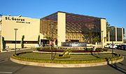
called Westfield Hurstville
Westfield Hurstville
Westfield Hurstville is a Westfield shopping centre in the southern suburb of Hurstville in Sydney, New South Wales, Australia at . Westfield Hurstville is the largest shopping centre in the St George area. It was officially opened in October 1978 by NSW Premier Neville Wran with 120 stores...
.
St George name
Several major local institutions have 'St. George' in their title:- St. George Asian Business Association.
- St. George BankSt. George BankSt.George Bank is a subsidiary of Westpac Banking Corporation trading primarily in New South Wales but with growing representation across a number of industry and business segments in Queensland and Western Australia. St.George also operates in South Australia and the Northern Territory under its...
- St. George Basketball Association
- St. George Cabs
- St. George College, TAFE NSW Sydney Institute
- St. George & Sutherland Community College
- St. George Crows AFC
- St. George DragonsSt. George DragonsThe St George Dragons was an Australian Rugby league football club in St George, Sydney, New South Wales that played in Australia's top-level Rugby league competition from New South Wales Rugby Football League in 1921 until 1998; in 1999 they formed a joint venture with the Illawarra Steelers,...
District Junior Rugby League - St. George Girls High School
- St George Christian SchoolSt George Christian SchoolSt George Christian School is an independent, co-educational, day school, located in Hurstville and Sans Souci, both suburbs of southern Sydney, in the St George area of New South Wales, Australia....
- St. George HospitalSt George Hospital, SydneyThe St George Hospital and Community Health Service is a tertiary referral hospital located in Kogarah, a southern suburb of Sydney, NSW, Australia...
- St. George Illawarra Dragons (Rugby LeagueRugby leagueRugby league football, usually called rugby league, is a full contact sport played by two teams of thirteen players on a rectangular grass field. One of the two codes of rugby football, it originated in England in 1895 by a split from Rugby Football Union over paying players...
Team) - St. George Masonic Club
- St. George Motor Boat Club
- St. George Rowing Club
- St. George Rugby Union Club
- St. George Sailing Club
- St. George Soccer Football Association
- St George and Sutherland Shire LeaderSt George and Sutherland Shire LeaderThe St George and Sutherland Shire Leader is a Fairfax Media-owned community newspaper distributed in the southern Sydney region. With a readership of 287,000, the Leader is the most-read suburban newspaper in the Sydney Metropolitan Area...
newspaper