

Kyeemagh, New South Wales
Encyclopedia
Kyeemagh is a suburb
in southern
Sydney
, in the state of New South Wales
, Australia
. Kyeemagh is located 12 kilometres south of the Sydney central business district
, on the western shore of Botany Bay
. Kyeemagh is in the local government area of the City of Rockdale
and is part of the St George
area.
people.
The area between the Cooks River
and Georges River
was originally known as Seven Mile Beach. It was changed to Lady Robinson’s Beach in 1874 to honour Governor Sir Hercules Robinson’s wife. Cook Park is named after Samuel Cook who advocated it as a public pleasure area.
John Webb was given a 300 acres (1.2 km²) land grant in 1837 but did not settle on the land because it was too scrubby and arid for farming. In 1882, 309 acres (1.3 km²) were resumed for a sewage farm and another 311 acres (1.3 km²) were added later. The sewage farm was discontinued in 1916 when an ocean outfall was built and subdivision took place.
John Goode had property in West Botany Street, from which he built a private road to Seven Mile Beach, as Lady Robinsons Beach was known then. Goode Street was named in his honour, but this later became Bestic Street. Maps (Commonwealth Electoral Rolls, 1925, 1928) show a second street named in honour of John Goode, off Bestic Street. Alderman E.G. Barton, worked to develop the district, including the reclamation 120 acre (0.4856232 km²) of swampland where Barton Park and Kogarah Golf Links now stand. James Beehag also owned land in the area and later became one of Rockdale's early mayors.
 Kyeemagh is located on the southern bank of the Cooks River
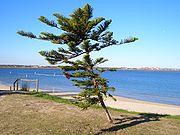
and the eastern bank of Muddy Creek. Lady Robinson Beach
and Cook Park run along the eastern border. A small group of shops is located in Bestic Street near General Holmes Drive. Other parks include Kyeemagh Reserve and Lance Stoddert Reserve.
The Brighton-Le Sands Amateur Fisherman's Association and TS Sirius, an Australian Navy Cadet
unit, is located in Bestic Street, beside Muddy Creek. C-side restaurant, part of the Cyprus-Hellene Club (formerly the site of Hashams take-away shop), is located in Cooks Park, on General Holmes Drive, close to the beach.
The Endeavour Bridge
links Kyeemagh to Sydney Airport
, Botany
and Mascot
. The entrance of the M5 Motorway
is also located here which links to Arncliffe
, Kingsgrove
, Beverly Hills
and west to Liverpool
and Campbelltown
. Kyeemagh Infants School is located on Beehag and Jacobson Avenues.
Census
of Population, there were 780 people usually resident in Kyeemagh. 37.5% stated they were born overseas with the top countries of birth being Greece 10.5%, Lebanon 2.3 % and Cyprus 2.2%. English was stated as the only language spoken at home by 44.3% of residents and the most common other languages spoken were Greek 27.5%, Arabic 6.9% and Spanish 4.0%. The most common responses for religious affiliation were Orthodox
35.6%, Catholic
30.8% and Anglican 9.4%.
Suburb
The word suburb mostly refers to a residential area, either existing as part of a city or as a separate residential community within commuting distance of a city . Some suburbs have a degree of administrative autonomy, and most have lower population density than inner city neighborhoods...
in southern
Southern Sydney
This article refers to an area the same as a combination of St George and SutherlandSouthern Sydney is a general term which is used to describe the southern metropolitan area of Sydney, in the state of New South Wales, Australia....
Sydney
Sydney
Sydney is the most populous city in Australia and the state capital of New South Wales. Sydney is located on Australia's south-east coast of the Tasman Sea. As of June 2010, the greater metropolitan area had an approximate population of 4.6 million people...
, in the state of New South Wales
New South Wales
New South Wales is a state of :Australia, located in the east of the country. It is bordered by Queensland, Victoria and South Australia to the north, south and west respectively. To the east, the state is bordered by the Tasman Sea, which forms part of the Pacific Ocean. New South Wales...
, Australia
Australia
Australia , officially the Commonwealth of Australia, is a country in the Southern Hemisphere comprising the mainland of the Australian continent, the island of Tasmania, and numerous smaller islands in the Indian and Pacific Oceans. It is the world's sixth-largest country by total area...
. Kyeemagh is located 12 kilometres south of the Sydney central business district
Sydney central business district
The Sydney central business district is the main commercial centre of Sydney, New South Wales, Australia. It extends southwards for about 3 kilometres from Sydney Cove, the point of first European settlement. Its north–south axis runs from Circular Quay in the north to Central railway station in...
, on the western shore of Botany Bay
Botany Bay
Botany Bay is a bay in Sydney, New South Wales, a few kilometres south of the Sydney central business district. The Cooks River and the Georges River are the two major tributaries that flow into the bay...
. Kyeemagh is in the local government area of the City of Rockdale
City of Rockdale
The City of Rockdale is a Local Government Area in southern Sydney, in the state of New South Wales, Australia. The city centre is located 12 kilometres south-south-west of the Sydney central business district, on the western shores of Botany Bay...
and is part of the St George
St George, New South Wales
St George Area is an unofficial name applied to a group of southern suburbs in Sydney, in the state of New South Wales, Australia. The area includes all the suburbs in the local government areas of the City of Hurstville, the City of Rockdale and the Municipality of Kogarah...
area.
History
Kyeemagh is an Aboriginal name meaning 'beautiful dawn'. Prior to European settlement it was part of the lands of the CadigalCadigal
The Cadigal, also spelled as Gadigal, are a group of Aboriginal Australians who originally inhabited the area that they called 'Cadi', part of which later became known as the Marrickville Local Government Area of Sydney. Cadigal territory lies south of Port Jackson and stretches from South Head to...
people.
The area between the Cooks River
Cooks River
The Cooks River is a 23 kilometre long urban waterway of south-western Sydney, New South Wales, Australia emptying into Botany Bay. The course of the river has been altered to accommodate various developments along its shore...
and Georges River
Georges River
The Georges River is a waterway in the state of New South Wales in Australia. It rises to the south-west of Sydney near the coal mining town of Appin, and then flows north past Campbelltown, roughly parallel to the Main South Railway...
was originally known as Seven Mile Beach. It was changed to Lady Robinson’s Beach in 1874 to honour Governor Sir Hercules Robinson’s wife. Cook Park is named after Samuel Cook who advocated it as a public pleasure area.
John Webb was given a 300 acres (1.2 km²) land grant in 1837 but did not settle on the land because it was too scrubby and arid for farming. In 1882, 309 acres (1.3 km²) were resumed for a sewage farm and another 311 acres (1.3 km²) were added later. The sewage farm was discontinued in 1916 when an ocean outfall was built and subdivision took place.
John Goode had property in West Botany Street, from which he built a private road to Seven Mile Beach, as Lady Robinsons Beach was known then. Goode Street was named in his honour, but this later became Bestic Street. Maps (Commonwealth Electoral Rolls, 1925, 1928) show a second street named in honour of John Goode, off Bestic Street. Alderman E.G. Barton, worked to develop the district, including the reclamation 120 acre (0.4856232 km²) of swampland where Barton Park and Kogarah Golf Links now stand. James Beehag also owned land in the area and later became one of Rockdale's early mayors.
Landmarks
Cooks River
The Cooks River is a 23 kilometre long urban waterway of south-western Sydney, New South Wales, Australia emptying into Botany Bay. The course of the river has been altered to accommodate various developments along its shore...
and the eastern bank of Muddy Creek. Lady Robinson Beach
Lady Robinson Beach
Lady Robinsons Beach is the stretch of beach between the mouth of the Cooks River and the mouth of Georges River on the western shore of Botany Bay. Originally the beach was known as Seven Mile Beach. The beach was renamed after the wife of the then Governor, Sir Hercules Robinson...
and Cook Park run along the eastern border. A small group of shops is located in Bestic Street near General Holmes Drive. Other parks include Kyeemagh Reserve and Lance Stoddert Reserve.
The Brighton-Le Sands Amateur Fisherman's Association and TS Sirius, an Australian Navy Cadet
Australian Navy Cadets
The Australian Navy Cadets is a voluntary youth organisation sponsored by the Royal Australian Navy. Together with the Australian Air Force Cadets and Australian Army Cadets, it forms the Australian Defence Force Cadets. It hosts over 91 units.-History:...
unit, is located in Bestic Street, beside Muddy Creek. C-side restaurant, part of the Cyprus-Hellene Club (formerly the site of Hashams take-away shop), is located in Cooks Park, on General Holmes Drive, close to the beach.
The Endeavour Bridge
Endeavour Bridge
Endeavour Bridge is a road crossing of the Cooks River, close to Botany Bay, in southern Sydney, New South Wales, Australia. It carries the General Holmes Drive, linking Sydney Airport at Mascot to Kyeemagh.- History :...
links Kyeemagh to Sydney Airport
Sydney Airport
Sydney Airport may refer to:* Sydney Airport, also known as Kingsford Smith International Airport, in Sydney, Australia* Sydney/J.A. Douglas McCurdy Airport, in Nova Scotia, Canada...
, Botany
Botany, New South Wales
Botany is a suburb in south-eastern Sydney, in the state of New South Wales, Australia. Botany is located 10 kilometres south of the Sydney central business district and is part of the City of Botany Bay....
and Mascot
Mascot, New South Wales
Mascot is a suburb in south-eastern Sydney, in the state of New South Wales, Australia. Mascot is located 7 kilometres south of the Sydney central business district and is the administrative centre of the City of Botany Bay...
. The entrance of the M5 Motorway
M5 South Western Motorway
The M5 South Western Motorway is a privately operated tolled motorway in south-western Sydney, New South Wales, Australia. It forms part of Sydney Metroad 5 and the Sydney Orbital Network...
is also located here which links to Arncliffe
Arncliffe, New South Wales
Arncliffe is a suburb in southern Sydney, in the state of New South Wales, Australia. Arncliffe is located 11 kilometres south of the Sydney central business district, in the local government area of the City of Rockdale. Arncliffe is part of the St George area.Arncliffe is located south of the...
, Kingsgrove
Kingsgrove, New South Wales
Kingsgrove is a suburb in southern Sydney, in the state of New South Wales, Australia. Kingsgrove is located 13 kilometres south of the Sydney central business district and lies across the local government areas of the City of Rockdale, the City of Hurstville and the City of Canterbury...
, Beverly Hills
Beverly Hills, New South Wales
Beverly Hills is a suburb in southern Sydney, in the state of New South Wales, Australia. Beverly Hills is located 17 kilometres south of the Sydney central business district and is part of the St George area. Beverly Hills lies across two local government areas, the City of Hurstville and the...
and west to Liverpool
Liverpool, New South Wales
Liverpool is a suburb in south-western Sydney, in the state of New South Wales, Australia. Liverpool is located 32 km south-west of the Sydney central business district, and is the administrative centre of the local government area of the City of Liverpool...
and Campbelltown
Campbelltown, New South Wales
Campbelltown is a suburb in south-western Sydney, in the state of New South Wales, Australia. Campbelltown is located 51 kilometres south-west of the Sydney central business district and is the administrative centre for the local government area of the City of Campbelltown.- History :Campbelltown...
. Kyeemagh Infants School is located on Beehag and Jacobson Avenues.
Population
According to the 2006 Australian Bureau of StatisticsAustralian Bureau of Statistics
The Australian Bureau of Statistics is Australia's national statistical agency. It was created as the Commonwealth Bureau of Census and Statistics on 8 December 1905, when the Census and Statistics Act 1905 was given Royal assent. It had its beginnings in section 51 of the Constitution of Australia...
Census
Census
A census is the procedure of systematically acquiring and recording information about the members of a given population. It is a regularly occurring and official count of a particular population. The term is used mostly in connection with national population and housing censuses; other common...
of Population, there were 780 people usually resident in Kyeemagh. 37.5% stated they were born overseas with the top countries of birth being Greece 10.5%, Lebanon 2.3 % and Cyprus 2.2%. English was stated as the only language spoken at home by 44.3% of residents and the most common other languages spoken were Greek 27.5%, Arabic 6.9% and Spanish 4.0%. The most common responses for religious affiliation were Orthodox
Eastern Orthodox Church
The Orthodox Church, officially called the Orthodox Catholic Church and commonly referred to as the Eastern Orthodox Church, is the second largest Christian denomination in the world, with an estimated 300 million adherents mainly in the countries of Belarus, Bulgaria, Cyprus, Georgia, Greece,...
35.6%, Catholic
Roman Catholic Church
The Catholic Church, also known as the Roman Catholic Church, is the world's largest Christian church, with over a billion members. Led by the Pope, it defines its mission as spreading the gospel of Jesus Christ, administering the sacraments and exercising charity...
30.8% and Anglican 9.4%.