
Turrella, New South Wales
Encyclopedia
Suburb
The word suburb mostly refers to a residential area, either existing as part of a city or as a separate residential community within commuting distance of a city . Some suburbs have a degree of administrative autonomy, and most have lower population density than inner city neighborhoods...
in southern
Southern Sydney
This article refers to an area the same as a combination of St George and SutherlandSouthern Sydney is a general term which is used to describe the southern metropolitan area of Sydney, in the state of New South Wales, Australia....
Sydney
Sydney
Sydney is the most populous city in Australia and the state capital of New South Wales. Sydney is located on Australia's south-east coast of the Tasman Sea. As of June 2010, the greater metropolitan area had an approximate population of 4.6 million people...
, in the state of New South Wales
New South Wales
New South Wales is a state of :Australia, located in the east of the country. It is bordered by Queensland, Victoria and South Australia to the north, south and west respectively. To the east, the state is bordered by the Tasman Sea, which forms part of the Pacific Ocean. New South Wales...
, Australia
Australia
Australia , officially the Commonwealth of Australia, is a country in the Southern Hemisphere comprising the mainland of the Australian continent, the island of Tasmania, and numerous smaller islands in the Indian and Pacific Oceans. It is the world's sixth-largest country by total area...
. Turrella is located 10 km south of the Sydney central business district
Sydney central business district
The Sydney central business district is the main commercial centre of Sydney, New South Wales, Australia. It extends southwards for about 3 kilometres from Sydney Cove, the point of first European settlement. Its north–south axis runs from Circular Quay in the north to Central railway station in...
on the southern bank of Wolli Creek
Wolli Creek
Wolli Creek is an urban waterway of southern Sydney, New South Wales, Australia. The sub-catchment is 22 km².Wolli Creek rises at Beverly Hills, at Beverly Hills Park. It is a lined channel between Kingsgrove Road, Kingsgrove and Bexley Road, Bexley North where it then enters the Wolli Creek...
. Turrella is in the local government area of the City of Rockdale
City of Rockdale
The City of Rockdale is a Local Government Area in southern Sydney, in the state of New South Wales, Australia. The city centre is located 12 kilometres south-south-west of the Sydney central business district, on the western shores of Botany Bay...
and is part of the St George
St George, New South Wales
St George Area is an unofficial name applied to a group of southern suburbs in Sydney, in the state of New South Wales, Australia. The area includes all the suburbs in the local government areas of the City of Hurstville, the City of Rockdale and the Municipality of Kogarah...
area.
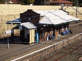
Turrella is a mostly residential area. Some light industrial developments are located around Turrella railway station and north along the railway line. A footbridge over Wolli Creek links Henderson Street to Undercliffe
Undercliffe, New South Wales
Undercliffe is a suburb in south-western Sydney, in the state of New South Wales, Australia. Undercliffe is located 10 kilometres south-west of the Sydney central business district in the local government area of the City of Canterbury....
.
History
Turrella is an aboriginal word for reedy place or water weeds. Wolli Creek which runs through the area was originally known as Woolly Creek, quite likely because the reeds in the water gave it a thick, woolly appearance.In 1842 William Favell and his wife Eleanor were farming a property named Hillside on this site. Their neighbours were the families of Thomas Curtis and Henry Blackwell, who were orchardists and gardeners. The farms and orchards were subdivided when the railway came through. The railway station opened on 21 September 1931. The light industrial buildings were built close to the railway line and one of the biggest factories in the area was the Streets Ice Cream
Streets (ice cream)
Streets Ice-cream is an Australian ice-cream brand owned by the multi-national company, Unilever.Streets was founded in Corrimal, New South Wales in the 1930s by Edwin 'Ted' Street and Gordon Rider and is now Australia's largest ice-cream manufacturer. Products were manufactured at a factory in the...
factory, which has since closed.
The post office was originally known as West Arncliffe when it opened on the 26th April 1933 but in January 1948 became known as Arncliffe West. It became Turrella in August 1952 but closed on the 21st December 1970.
Wolli Creek and Bardwell Valley
Arncliffe borders an extremely important piece of remnant bushland, the Wolli Creek Valley, beside Wolli CreekWolli Creek
Wolli Creek is an urban waterway of southern Sydney, New South Wales, Australia. The sub-catchment is 22 km².Wolli Creek rises at Beverly Hills, at Beverly Hills Park. It is a lined channel between Kingsgrove Road, Kingsgrove and Bexley Road, Bexley North where it then enters the Wolli Creek...
. There have been very active movements fighting for its preservation in the face of demands for land. The most successful of these prevented the building of the M5 South Western Motorway
M5 South Western Motorway
The M5 South Western Motorway is a privately operated tolled motorway in south-western Sydney, New South Wales, Australia. It forms part of Sydney Metroad 5 and the Sydney Orbital Network...
through the valley, resulting in the road being built as a tunnel under the valley. Nevertheless, community concern remains over what is seen as the release of unfiltered particle pollution from exhaust emissions into the atmosphere in the Bardwell Valley.
Schools
Arncliffe West Public School is located in Loftus Street and Cairnsfoot Special School is located opposite. The original Cairnsfoot building is heritage listed.One well known headmistress of the school was Miss Knight who served there in the 1950's and 1960's.
Transport
Turrella railway station is on the East Hills line of the City Rail network. Turrella is also serviced by the 473 government bus route which runs from RockdaleRockdale, New South Wales
Rockdale is a suburb in southern Sydney, in the state of New South Wales, Australia. Rockdale is located 13 kilometres south of the Sydney central business district and is part of the St George area...
, Bardwell Valley
Bardwell Valley, New South Wales
Bardwell Valley is a suburb in southern Sydney, in the state of New South Wales, Australia. Bardwell Valley is located approximately 12 kilometres south of the Sydney central business district, in the local government area of the City of Rockdale and is part of the St George area.Bardwell Valley...
, Arncliffe
Arncliffe, New South Wales
Arncliffe is a suburb in southern Sydney, in the state of New South Wales, Australia. Arncliffe is located 11 kilometres south of the Sydney central business district, in the local government area of the City of Rockdale. Arncliffe is part of the St George area.Arncliffe is located south of the...
, Turrella, Bardwell Park station, Earlwood
Earlwood, New South Wales
Earlwood is a suburb in the inner-west of Sydney, in the state of New South Wales, Australia. Earlwood is located 12 kilometres south of the Sydney central business district, in the local government area of the City of Canterbury...
, Clemton Park
Clemton Park, New South Wales
Clemton Park is a suburb in south-western Sydney, in the state of New South Wales, Australia. Clemton Park is located 13 kilometres south-west of the Sydney central business district in the City of Canterbury. A small group of shops is located at the intersection of Bexley Road and William Street....
, and on to Campsie
Campsie, New South Wales
Campsie is a suburb in south-western Sydney, in the state of New South Wales, Australia. Campsie is located 13 kilometres south-west of the Sydney central business district, on the southern bank of the Cooks River. Campsie is the commercial and administrative centre of the City of...
.
The M5 South Western Motorway
M5 South Western Motorway
The M5 South Western Motorway is a privately operated tolled motorway in south-western Sydney, New South Wales, Australia. It forms part of Sydney Metroad 5 and the Sydney Orbital Network...
runs beneath parts of Turrella, in a 4 km tunnel. The nearest entrances to travel south-west towards Beverly Hills
Beverly Hills, New South Wales
Beverly Hills is a suburb in southern Sydney, in the state of New South Wales, Australia. Beverly Hills is located 17 kilometres south of the Sydney central business district and is part of the St George area. Beverly Hills lies across two local government areas, the City of Hurstville and the...
and Liverpool
Liverpool, New South Wales
Liverpool is a suburb in south-western Sydney, in the state of New South Wales, Australia. Liverpool is located 32 km south-west of the Sydney central business district, and is the administrative centre of the local government area of the City of Liverpool...
are located at Arncliffe
Arncliffe, New South Wales
Arncliffe is a suburb in southern Sydney, in the state of New South Wales, Australia. Arncliffe is located 11 kilometres south of the Sydney central business district, in the local government area of the City of Rockdale. Arncliffe is part of the St George area.Arncliffe is located south of the...
and Bexley North
Bexley North, New South Wales
Bexley North is a suburb in southern Sydney, in the state of New South Wales, Australia. It is located 13 kilometres south of the Sydney central business district and is part of the St George area. Bexley North is in the local government area of the City of Rockdale.-History:James Chandler named...
. The nearest entrances to travel north-east towards Botany
Botany, New South Wales
Botany is a suburb in south-eastern Sydney, in the state of New South Wales, Australia. Botany is located 10 kilometres south of the Sydney central business district and is part of the City of Botany Bay....
and the city are located at Kingsgrove
Kingsgrove, New South Wales
Kingsgrove is a suburb in southern Sydney, in the state of New South Wales, Australia. Kingsgrove is located 13 kilometres south of the Sydney central business district and lies across the local government areas of the City of Rockdale, the City of Hurstville and the City of Canterbury...
and Arncliffe
Arncliffe, New South Wales
Arncliffe is a suburb in southern Sydney, in the state of New South Wales, Australia. Arncliffe is located 11 kilometres south of the Sydney central business district, in the local government area of the City of Rockdale. Arncliffe is part of the St George area.Arncliffe is located south of the...
.
Population
According to the 2006 Australian Bureau of StatisticsAustralian Bureau of Statistics
The Australian Bureau of Statistics is Australia's national statistical agency. It was created as the Commonwealth Bureau of Census and Statistics on 8 December 1905, when the Census and Statistics Act 1905 was given Royal assent. It had its beginnings in section 51 of the Constitution of Australia...
Census
Census
A census is the procedure of systematically acquiring and recording information about the members of a given population. It is a regularly occurring and official count of a particular population. The term is used mostly in connection with national population and housing censuses; other common...
of Population, there were 1,011 people usually resident in Turrella. 39.4% stated they were born overseas with the top countries of birth being Lebanon 10.8%, Macedonia 7.5% and China 2.6%. English was stated as the only language spoken at home by 41.8% of residents and the most common other languages spoken were Arabic 28.7%, Macedonian 12.7% and Italian 4.3%. The most common responses for religious affiliation were Islam
Islam
Islam . The most common are and . : Arabic pronunciation varies regionally. The first vowel ranges from ~~. The second vowel ranges from ~~~...
27.0%, Catholic
Roman Catholic Church
The Catholic Church, also known as the Roman Catholic Church, is the world's largest Christian church, with over a billion members. Led by the Pope, it defines its mission as spreading the gospel of Jesus Christ, administering the sacraments and exercising charity...
20.7% and Orthodox
Eastern Orthodox Church
The Orthodox Church, officially called the Orthodox Catholic Church and commonly referred to as the Eastern Orthodox Church, is the second largest Christian denomination in the world, with an estimated 300 million adherents mainly in the countries of Belarus, Bulgaria, Cyprus, Georgia, Greece,...
15.4%.