
Narwee, New South Wales
Encyclopedia
Narwee is a suburb
in southern
Sydney
, in the state of New South Wales
, Australia
. Narwee is located 18 kilometres south of the Sydney central business district
and is part of the St George
area. Narwee lies across the local government areas of the City of Hurstville
and the City of Canterbury
. The postcode is 2209, which it shares with neighbouring Beverly Hills.
The main street of Narwee is Broad Arrow Road, which runs from King Georges Road in Beverly Hills
to just past Bonds Road in Riverwood
. Broadarrow Road is also the boundary line between the northern part in the City of Canterbury, and the southern part in the City of Hurstville.
, and Jannali
. Jannali supposedly means "moon" and was apparently named at the same time as Narwee, as a "sister suburb".
The name Narwee was adopted when the railway station opened on the 21st December 1931. People living there at the time were mostly poultry farmers and market gardeners, and a city florist had a large garden west of the railway station. After the railway came through, people bought up land for residences. Little building was done during the Depression and World War II, but the suburb grew rapidly in the 1950s, when the area was settled by young families. The post office opened in 1948.
Narwee Primary School is built on land given in 1809, to Richard Podmore, a free settler, who came to New South Wales as a soldier in the N.S.W. Corps in 1792, on the ship "Pitt". Land between today's Penshurst Road and King Georges Road belonged to Richard Tuckwell, another soldier from the same Company. At the time of the land, the area was covered with a very thick ironbark forest.
Tuckwell and Podmore sold their grants to Patrick Moore and Robert Gardner, both ex-convicts, in 1819 and 1820, and "Bob the Gardener", as he was known, began to clear trees and develop a farm on Podmore's grant, which he called "Sunning Hill Farm". The property was later extended to cover Emery's 30 acres (121,405.8 m²) grant next door. This was farmed by Gardner's adopted son, Thomas Gardner Whitehall.
At that stage there were very few farms in the district. Men earned a living by cutting down the trees and selling the logs for firewood and timber to build houses and boats. Narwee did not exist as a locality; it was called "Bob the Gardner's Farm", and there were so few people living in the area that bushrangers could easily hide for weeks in the forest without being discovered.
network, with Riverwood to the west and Beverly Hills to the east. This station is served by an 'all stations' service that runs every 15 minutes on weekdays, and half hourly on weekends.
was located at the suburb's highest point but closed in 2001. It has been redeveloped into a complex of residential houses.
Census
of Population, there were 5,021 people usually resident in Narwee. 43.5 % stated they were born overseas with the top countries of birth being China 13.1%, Hong Kong 3.9% and Greece 2.1%. English was stated as the only language spoken at home by 45.1% of residents and the most common other languages spoken were Cantonese 15.4%, Mandarin 8.7% and Arabic 6.0%. The most common responses for religious affiliation were Catholic
24.3%, Anglican 11.7% and Orthodox
8.2%.
Suburb
The word suburb mostly refers to a residential area, either existing as part of a city or as a separate residential community within commuting distance of a city . Some suburbs have a degree of administrative autonomy, and most have lower population density than inner city neighborhoods...
in southern
Southern Sydney
This article refers to an area the same as a combination of St George and SutherlandSouthern Sydney is a general term which is used to describe the southern metropolitan area of Sydney, in the state of New South Wales, Australia....
Sydney
Sydney
Sydney is the most populous city in Australia and the state capital of New South Wales. Sydney is located on Australia's south-east coast of the Tasman Sea. As of June 2010, the greater metropolitan area had an approximate population of 4.6 million people...
, in the state of New South Wales
New South Wales
New South Wales is a state of :Australia, located in the east of the country. It is bordered by Queensland, Victoria and South Australia to the north, south and west respectively. To the east, the state is bordered by the Tasman Sea, which forms part of the Pacific Ocean. New South Wales...
, Australia
Australia
Australia , officially the Commonwealth of Australia, is a country in the Southern Hemisphere comprising the mainland of the Australian continent, the island of Tasmania, and numerous smaller islands in the Indian and Pacific Oceans. It is the world's sixth-largest country by total area...
. Narwee is located 18 kilometres south of the Sydney central business district
Sydney central business district
The Sydney central business district is the main commercial centre of Sydney, New South Wales, Australia. It extends southwards for about 3 kilometres from Sydney Cove, the point of first European settlement. Its north–south axis runs from Circular Quay in the north to Central railway station in...
and is part of the St George
St George, New South Wales
St George Area is an unofficial name applied to a group of southern suburbs in Sydney, in the state of New South Wales, Australia. The area includes all the suburbs in the local government areas of the City of Hurstville, the City of Rockdale and the Municipality of Kogarah...
area. Narwee lies across the local government areas of the City of Hurstville
City of Hurstville
The City of Hurstville is a Local Government Area in southern Sydney, in the state of New South Wales, Australia. The city centre is located 17km SSW of the Sydney central business district and west of Botany Bay....
and the City of Canterbury
City of Canterbury, New South Wales
The City of Canterbury, previously the Municipality of Canterbury, is a Local Government Area in Sydney, New South Wales, Australia. It lies southwest of the central business district and forms part of the Greater Sydney metropolitan area....
. The postcode is 2209, which it shares with neighbouring Beverly Hills.
The main street of Narwee is Broad Arrow Road, which runs from King Georges Road in Beverly Hills
Beverly Hills, New South Wales
Beverly Hills is a suburb in southern Sydney, in the state of New South Wales, Australia. Beverly Hills is located 17 kilometres south of the Sydney central business district and is part of the St George area. Beverly Hills lies across two local government areas, the City of Hurstville and the...
to just past Bonds Road in Riverwood
Riverwood, New South Wales
Riverwood is a suburb in southern Sydney, in the state of New South Wales, Australia. Riverwood is located 18 kilometres south-west of the Sydney central business district and is part of the St George area...
. Broadarrow Road is also the boundary line between the northern part in the City of Canterbury, and the southern part in the City of Hurstville.
History
Narwee is an Aboriginal word meaning "sun", an appropriate name for an area once called 'Sunning Hill Farm'. The language and dialect it was derived from is unclear. A number of Sydney suburbs developed during the 1930s have similar allegedly Aboriginal names, the origins of which are uncertain, including nearby PananiaPanania, New South Wales
Panania, a suburb of local government area City of Bankstown, is located 23 kilometres inner south-west of the Sydney central business district in the state of New South Wales, Australia, and is a part of the South-western Sydney region...
, and Jannali
Jannali, New South Wales
Jannali is a suburb in southern Sydney, in the state of New South Wales, Australia. Jannali is located 28 kilometres south of the Sydney central business district in the local government area of the Sutherland Shire...
. Jannali supposedly means "moon" and was apparently named at the same time as Narwee, as a "sister suburb".
The name Narwee was adopted when the railway station opened on the 21st December 1931. People living there at the time were mostly poultry farmers and market gardeners, and a city florist had a large garden west of the railway station. After the railway came through, people bought up land for residences. Little building was done during the Depression and World War II, but the suburb grew rapidly in the 1950s, when the area was settled by young families. The post office opened in 1948.
Narwee Primary School is built on land given in 1809, to Richard Podmore, a free settler, who came to New South Wales as a soldier in the N.S.W. Corps in 1792, on the ship "Pitt". Land between today's Penshurst Road and King Georges Road belonged to Richard Tuckwell, another soldier from the same Company. At the time of the land, the area was covered with a very thick ironbark forest.
Tuckwell and Podmore sold their grants to Patrick Moore and Robert Gardner, both ex-convicts, in 1819 and 1820, and "Bob the Gardener", as he was known, began to clear trees and develop a farm on Podmore's grant, which he called "Sunning Hill Farm". The property was later extended to cover Emery's 30 acres (121,405.8 m²) grant next door. This was farmed by Gardner's adopted son, Thomas Gardner Whitehall.
At that stage there were very few farms in the district. Men earned a living by cutting down the trees and selling the logs for firewood and timber to build houses and boats. Narwee did not exist as a locality; it was called "Bob the Gardner's Farm", and there were so few people living in the area that bushrangers could easily hide for weeks in the forest without being discovered.
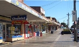
Commercial area
The main shopping strip is located in Broad Arrow Road parallel with and adjacent to Narwee railway station. Like many small suburbs, Narwee was formerly served by two banks (Westpac and Commonwealth) and many small shops. Both banks have now closed, although the post office remains.Transport
Narwee railway station is on the East Hills line of the CityRailCityRail
CityRail is an operating brand of RailCorp, a corporation owned by the state government of New South Wales, Australia. It is responsible for providing commuter rail services, and some coach services, in and around Sydney, Newcastle and Wollongong, the three largest cities of New South Wales. It is...
network, with Riverwood to the west and Beverly Hills to the east. This station is served by an 'all stations' service that runs every 15 minutes on weekdays, and half hourly on weekends.
Schools
Narwee has a public school and once had a high school. Narwee High SchoolNarwee High School
Narwee High School , known from 1958-1991 as Narwee Boys' High School , is a former high school in the southern Sydney suburb of Narwee, New South Wales, Australia....
was located at the suburb's highest point but closed in 2001. It has been redeveloped into a complex of residential houses.
Population
According to the 2006 Australian Bureau of StatisticsAustralian Bureau of Statistics
The Australian Bureau of Statistics is Australia's national statistical agency. It was created as the Commonwealth Bureau of Census and Statistics on 8 December 1905, when the Census and Statistics Act 1905 was given Royal assent. It had its beginnings in section 51 of the Constitution of Australia...
Census
Census
A census is the procedure of systematically acquiring and recording information about the members of a given population. It is a regularly occurring and official count of a particular population. The term is used mostly in connection with national population and housing censuses; other common...
of Population, there were 5,021 people usually resident in Narwee. 43.5 % stated they were born overseas with the top countries of birth being China 13.1%, Hong Kong 3.9% and Greece 2.1%. English was stated as the only language spoken at home by 45.1% of residents and the most common other languages spoken were Cantonese 15.4%, Mandarin 8.7% and Arabic 6.0%. The most common responses for religious affiliation were Catholic
Roman Catholic Church
The Catholic Church, also known as the Roman Catholic Church, is the world's largest Christian church, with over a billion members. Led by the Pope, it defines its mission as spreading the gospel of Jesus Christ, administering the sacraments and exercising charity...
24.3%, Anglican 11.7% and Orthodox
Eastern Orthodox Church
The Orthodox Church, officially called the Orthodox Catholic Church and commonly referred to as the Eastern Orthodox Church, is the second largest Christian denomination in the world, with an estimated 300 million adherents mainly in the countries of Belarus, Bulgaria, Cyprus, Georgia, Greece,...
8.2%.