
Georges River
Encyclopedia
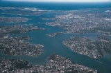
The Georges River is a waterway in the state of New South Wales
in Australia
. It rises to the south-west of Sydney
near the coal mining town of Appin
, and then flows north past Campbelltown
, roughly parallel to the Main South Railway. At Liverpool
it then turns east and flows past the suburbs of East Hills
, Lugarno
, and Blakehurst
, before emptying into Botany Bay
at Taren Point in the southern suburbs of Sydney.
Major tributaries include O'Hares Creek, Bunbury Curran Creek, Cabramatta Creek
, Prospect Creek
, Salt Pan Creek
and the Woronora River
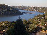
. The Georges River is popular for recreational activities such as water skiing and swimming. The banks of the river along the lower reaches are marked by large inlets and indentations overlooked by steep sandstone ridges and scarps, many being home to expensive residential properties.
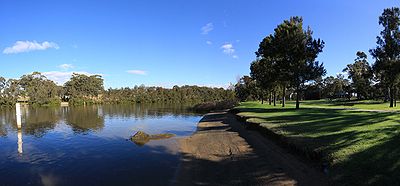
The Georges River features some artificial lakes in the suburb of Chipping Norton
, near Liverpool. These lakes, known as the Chipping Norton Lakes, are the result of sand mining and quarrying operations in the twentieth century. The Lakes are now a popular watersports and recreational facility for the residents of the south-western suburbs of Sydney
.
Liverpool Weir now forms the uppermost tidal limit and presence of salt water on the Georges River.
, by Governor Arthur Phillip.
The river was first explored by Bass
and Flinders
in 1795 on their first voyage on the Tom Thumb after their arrival in New South Wales. The exploration led to the establishment of Bankstown
.
A dam was constructed by David Lennox
using convict labour at Liverpool in 1836, as a water supply to Liverpool.
The bushland adjoing the River is some of the most pristine in Western Sydney. From Appin to Glenfield a large corridor has been protected as part of the Georges River Regional Open Space Corridor.Simmo's Beach Recreation Reserve, Ingleburn Reserve, Keith Longhurst Reserve, Frere's Crossing Reserve all allow for access to these pristine areas.
In February 2007, Liverpool and Campbelltown City Council were awarded a $2M grant from the NSW Environmental Trust under their Urban Sustainability Initiative The grant was to allow the councils, in conjunction with Wollondilly Shire Council and the Georges River Combined Councils Committee, to develop a Comprehensive Strategic Plan focused on the rehabilitation of the catchment area.
 Bridges over the Georges River include from east to west:
 The Georges River is a popular area for recreational fishing. Species present in the river include bream, whiting, yellowtail, jewfish and flathead. The river is also host to a number of commercial oyster farms. The upper ends of the Georges River are abundant with Bass during the summer months and during the winter months these bass migrate down to the lower ends of the river towards the salt water to breed. Waste water inflows to the river are carefully managed to maintain the estuarine habitat.
New South Wales
New South Wales is a state of :Australia, located in the east of the country. It is bordered by Queensland, Victoria and South Australia to the north, south and west respectively. To the east, the state is bordered by the Tasman Sea, which forms part of the Pacific Ocean. New South Wales...
in Australia
Australia
Australia , officially the Commonwealth of Australia, is a country in the Southern Hemisphere comprising the mainland of the Australian continent, the island of Tasmania, and numerous smaller islands in the Indian and Pacific Oceans. It is the world's sixth-largest country by total area...
. It rises to the south-west of Sydney
Sydney
Sydney is the most populous city in Australia and the state capital of New South Wales. Sydney is located on Australia's south-east coast of the Tasman Sea. As of June 2010, the greater metropolitan area had an approximate population of 4.6 million people...
near the coal mining town of Appin
Appin, New South Wales
Appin is a town in the Macarthur Region of New South Wales, Australia in Wollondilly Shire. It is situated about 16 kilometres south of Campbelltown and 35 kilometres north west of Wollongong.-Early history:...
, and then flows north past Campbelltown
Campbelltown, New South Wales
Campbelltown is a suburb in south-western Sydney, in the state of New South Wales, Australia. Campbelltown is located 51 kilometres south-west of the Sydney central business district and is the administrative centre for the local government area of the City of Campbelltown.- History :Campbelltown...
, roughly parallel to the Main South Railway. At Liverpool
Liverpool, New South Wales
Liverpool is a suburb in south-western Sydney, in the state of New South Wales, Australia. Liverpool is located 32 km south-west of the Sydney central business district, and is the administrative centre of the local government area of the City of Liverpool...
it then turns east and flows past the suburbs of East Hills
East Hills, New South Wales
East Hills, a suburb of local government area City of Bankstown, is located 26 kilometres south-west of the Sydney central business district, in the state of New South Wales, Australia, and is a part of the South-western Sydney region....
, Lugarno
Lugarno, New South Wales
Lugarno is a suburb in southern Sydney, in the state of New South Wales, Australia. Lugarno is located 23 kilometres south of the Sydney central business district in the local government area of the City of Hurstville and is part of the St George area....
, and Blakehurst
Blakehurst, New South Wales
Blakehurst is a suburb in southern Sydney, in the state of New South Wales, Australia. Blakehurst is located 18 kilometres south of the Sydney central business district, in the local government area of the Municipality of Kogarah and is part of the St George area.Blakehurst is connected to...
, before emptying into Botany Bay
Botany Bay
Botany Bay is a bay in Sydney, New South Wales, a few kilometres south of the Sydney central business district. The Cooks River and the Georges River are the two major tributaries that flow into the bay...
at Taren Point in the southern suburbs of Sydney.
Major tributaries include O'Hares Creek, Bunbury Curran Creek, Cabramatta Creek
Cabramatta Creek
Cabramatta Creek is a creek in south-western Sydney, in the state of New South Wales, Australia. It feeds into the Georges River at the Chipping Norton Lake, next to Cabramatta.The area around the creek was home to the Darug Aboriginal people...
, Prospect Creek
Prospect Creek (New South Wales)
Prospect Creek is a small creek in south-western Sydney, in the state of New South Wales, Australia. It flows from the Prospect reservoir for about 17 km until joining the Georges River at Georges Hall into the Dhurawal bay, in the Chipping Norton Lake system.As the reservoir forms a part of the...
, Salt Pan Creek
Salt Pan Creek
Salt Pan Creek is a small creek located in the Salt Pan Creek catchment area, in south-western Sydney, in the state of New South Wales, Australia. It is located between the suburbs of Padstow and Riverwood and feeds into the Georges River. The catchment area covers about 26km2, with 11.7km2 of this...
and the Woronora River
Woronora River
The Woronora River flows north from near Helensburgh into the Georges River between Como and Illawong.- Crossings :The river is crossed by high level and low level road bridges and a footbridge in Woronora, New South Wales...
. The Georges River is popular for recreational activities such as water skiing and swimming. The banks of the river along the lower reaches are marked by large inlets and indentations overlooked by steep sandstone ridges and scarps, many being home to expensive residential properties.
The Georges River features some artificial lakes in the suburb of Chipping Norton
Chipping Norton, New South Wales
Chipping Norton is a suburb of Sydney, in the state of New South Wales, Australia. Chipping Norton is located 27 kilometres south-west of the Sydney central business district, in the local government area of the City of Liverpool and is part of the Greater Western Sydney region.-Aboriginal...
, near Liverpool. These lakes, known as the Chipping Norton Lakes, are the result of sand mining and quarrying operations in the twentieth century. The Lakes are now a popular watersports and recreational facility for the residents of the south-western suburbs of Sydney
Sydney
Sydney is the most populous city in Australia and the state capital of New South Wales. Sydney is located on Australia's south-east coast of the Tasman Sea. As of June 2010, the greater metropolitan area had an approximate population of 4.6 million people...
.
Liverpool Weir now forms the uppermost tidal limit and presence of salt water on the Georges River.
History
The Georges River was named after King George IIIGeorge III of the United Kingdom
George III was King of Great Britain and King of Ireland from 25 October 1760 until the union of these two countries on 1 January 1801, after which he was King of the United Kingdom of Great Britain and Ireland until his death...
, by Governor Arthur Phillip.
The river was first explored by Bass
George Bass
George Bass was a British naval surgeon and explorer of Australia.-Early years:He was born on 30 January 1771 at Aswarby, a hamlet near Sleaford, Lincolnshire, the son of a tenant farmer, George Bass, and a local beauty named Sarah Nee Newman. His father died in 1777 when Bass was 6...
and Flinders
Matthew Flinders
Captain Matthew Flinders RN was one of the most successful navigators and cartographers of his age. In a career that spanned just over twenty years, he sailed with Captain William Bligh, circumnavigated Australia and encouraged the use of that name for the continent, which had previously been...
in 1795 on their first voyage on the Tom Thumb after their arrival in New South Wales. The exploration led to the establishment of Bankstown
Bankstown, New South Wales
Bankstown is a suburb of south-western Sydney, in the state of New South Wales, Australia. Bankstown is located 20 kilometres south-west of the Sydney central business district and is the administrative centre of the local government area of the City of Bankstown.-History:Prior to European...
.
A dam was constructed by David Lennox
David Lennox
David Lennox was a Scottish-Australian bridge-builder and master stonemason born in Ayr, Scotland.-Personal details:...
using convict labour at Liverpool in 1836, as a water supply to Liverpool.
The Upper Georges River
The Upper Georges River originates 5 km south-east of Appin within heath habitat of Wollondilly Shire. The river flows north through rugged sandstone gorges until it reaches the urban environment beginning at Glenfield and then travels to the Liverpool Weir where it joins with the estuarine catchment. In total the Upper Georges catchment is approximately 360sqkm and falls across the Wollondilly, Campbelltown and Liverpool local government areas.The bushland adjoing the River is some of the most pristine in Western Sydney. From Appin to Glenfield a large corridor has been protected as part of the Georges River Regional Open Space Corridor.Simmo's Beach Recreation Reserve, Ingleburn Reserve, Keith Longhurst Reserve, Frere's Crossing Reserve all allow for access to these pristine areas.
In February 2007, Liverpool and Campbelltown City Council were awarded a $2M grant from the NSW Environmental Trust under their Urban Sustainability Initiative The grant was to allow the councils, in conjunction with Wollondilly Shire Council and the Georges River Combined Councils Committee, to develop a Comprehensive Strategic Plan focused on the rehabilitation of the catchment area.
Crossings
- Captain Cook BridgeCaptain Cook Bridge, New South WalesThe Captain Cook Bridge is one of three major road crossings of the Georges River in Sydney, Australia. It crosses at the mouth of the river into Botany Bay....
(connecting Sans SouciSans Souci, New South WalesSans Souci is a southern Sydney suburb in the state of New South Wales, Australia. Sans Souci is 17 kilometres south of the Sydney central business district and lies across the local government areas of the City of Rockdale and the Municipality of Kogarah. It is part of the St George area.Sans...
to Taren PointTaren Point, New South WalesTaren Point is a suburb, in southern Sydney, in the state of New South Wales, Australia. Taren Point is located 20 kilometres south of the Sydney central business district in the local government area of the Sutherland Shire....
), for cars, pedestrians and cyclists. - Tom Uglys BridgeTom Uglys BridgeTom Uglys Bridge is one of three major road crossings of the Georges River in southern Sydney, New South Wales, Australia. It consists of two separate bridges that carry the Princes Highway, linking the St George area at Blakehurst to the Sutherland Shire at Sylvania.- Origin of the name :Tom Uglys...
(connecting BlakehurstBlakehurst, New South WalesBlakehurst is a suburb in southern Sydney, in the state of New South Wales, Australia. Blakehurst is located 18 kilometres south of the Sydney central business district, in the local government area of the Municipality of Kogarah and is part of the St George area.Blakehurst is connected to...
to SylvaniaSylvania, New South WalesSylvania is a suburb, in southern Sydney, in the state of New South Wales, Australia. Sylvania is located 22 kilometres south of the Sydney central business district in the Sutherland Shire....
), for cars, pedestrians and cyclists. - Como old rail bridge, now for pedestrians and cyclists.
- Como rail bridge on the Illawarra Line, connecting OatleyOatley, New South WalesOatley is a suburb in southern Sydney, in the state of New South Wales, Australia. Oatley is located 21 kilometres south of the Sydney central business district and is part of the St George area...
to ComoComo, New South WalesComo is a suburb in southern Sydney, in the state of New South Wales, Australia. Como is located 27 kilometres south of the Sydney central business district in the local government area of the Sutherland Shire. The postcode is 2226, which it shares with neighbouring Jannali and Bonnet Bay...
, for trains. - Alfords Point Bridge (connecting Padstow HeightsPadstow Heights, New South WalesPadstow Heights, a suburb of local government area City of Bankstown, is located 23 kilometres south-west of the Sydney central business district, in the state of New South Wales, Australia, and is a part of the South-western Sydney region...
to Alfords PointAlfords Point, New South WalesAlfords Point is a suburb in southern Sydney, in the state of New South Wales, Australia. Alfords Point is located 28 kilometres south of the Sydney central business district, in the local government area of the Sutherland Shire in the area commonly called Menai...
), for cars, pedestrians and cyclists. - East Hills rail bridge, for trains.
- Voyager Point footbridge, for pedestrians and cyclists.
- M5 South Western MotorwayM5 South Western MotorwayThe M5 South Western Motorway is a privately operated tolled motorway in south-western Sydney, New South Wales, Australia. It forms part of Sydney Metroad 5 and the Sydney Orbital Network...
Georges River East Bridge - Newbridge Rd
- Liverpool footbridge (utilises the footing of the decommissioned railway bridge to Holsworthy).
- Newbridge Rd
- M5 South Western Motorway Georges River West Bridge
- King Falls Bridge
Fish