
Wolli Creek, New South Wales
Encyclopedia
For the urban waterway see Wolli Creek
Wolli Creek is a suburb
in southern
Sydney
, in the state of New South Wales
, Australia
. It sits beside the Wolli Creek
and Cooks River
waterways. Wolli Creek is situated between the suburbs of Arncliffe
and Tempe
, 10 kilometres south of the Sydney central business district
, in the local government area of the City of Rockdale
and is part of the St George
area.
 Wolli Creek was named after the waterway on its northern border.
The suburb was previously part of Arncliffe
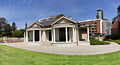
. Reuben Hannam was granted land in 1825 on the banks of Cooks river. Alexander Brodie Spark
purchased land in 1826 and built Tempe house in 1836. It was named after 'Vale of Tempe', a beautiful valley in ancient Greek legend set at the foot of Mount Olympus. Tempe House, designed by John Verge
, has a Georgian feel and is regarded as one of the great houses of Sydney.
Philanthropist Caroline Chisholm
leased Tempe House as a boarding school for young women (1863–1865). The estate was known as Greenbank during this time and presented an ideal location for Chisholm's work. She remarked on the spacious and lofty rooms and the 'fine large and open orchard of fruit trees, intersected by wide and shady walks'.
In 1884 the estate was sold to the Sisters of the Good Samaritan
for use as a charitable refuge for women. The Sisters added the impressive St Magdalen's Chapel (1888), which is believed to be the work of Sheerin & Hennessy, an important firm of Sydney architects, who designed the Archbishop's Residence and St Patrick's College at Manly. The neo-Gothic style Chapel is of major cultural significance. It is now deconsecrated and has been restored as part of the Discovery Point redevelopment. Tempe House is now listed on the Register of the National Estate
.
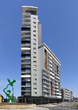
The area became predominantly industrial until a redevelopment was planned in the late 1990s. The new suburb was to be called North Arncliffe, but residents in the area petitioned the council to conduct a vote to select a better name. Wolli Creek was the most popular choice. Wolli Creek railway station opened in 2000. Wolli Creek was officially declared a suburb in 2002.
make it an attractive residential area. A shopping centre has begun forming around the intersection of Brodie Sparks Drive and Arncliffe Street, near Wolli Creek railway station.
links Wolli Creek north to Tempe
and the Sydney CBD and south to Arncliffe
and Rockdale
. The M5 South Western Motorway
, with entrances and exits at nearby Arncliffe, runs south-west towards Liverpool
and north-east towards Botany
and the city.
Wolli Creek railway station is a railway junction for the Illawarra line and East Hills line on the City Rail network. The train trip to Town Hall railway station takes approximately 16 minutes on the Illawarra line via Sydenham
, while the trip to Museum railway station takes approximately 18 minutes on the East Hills line via the Airport
.
Wolli Creek
Wolli Creek is an urban waterway of southern Sydney, New South Wales, Australia. The sub-catchment is 22 km².Wolli Creek rises at Beverly Hills, at Beverly Hills Park. It is a lined channel between Kingsgrove Road, Kingsgrove and Bexley Road, Bexley North where it then enters the Wolli Creek...
Wolli Creek is a suburb
Suburb
The word suburb mostly refers to a residential area, either existing as part of a city or as a separate residential community within commuting distance of a city . Some suburbs have a degree of administrative autonomy, and most have lower population density than inner city neighborhoods...
in southern
Southern Sydney
This article refers to an area the same as a combination of St George and SutherlandSouthern Sydney is a general term which is used to describe the southern metropolitan area of Sydney, in the state of New South Wales, Australia....
Sydney
Sydney
Sydney is the most populous city in Australia and the state capital of New South Wales. Sydney is located on Australia's south-east coast of the Tasman Sea. As of June 2010, the greater metropolitan area had an approximate population of 4.6 million people...
, in the state of New South Wales
New South Wales
New South Wales is a state of :Australia, located in the east of the country. It is bordered by Queensland, Victoria and South Australia to the north, south and west respectively. To the east, the state is bordered by the Tasman Sea, which forms part of the Pacific Ocean. New South Wales...
, Australia
Australia
Australia , officially the Commonwealth of Australia, is a country in the Southern Hemisphere comprising the mainland of the Australian continent, the island of Tasmania, and numerous smaller islands in the Indian and Pacific Oceans. It is the world's sixth-largest country by total area...
. It sits beside the Wolli Creek
Wolli Creek
Wolli Creek is an urban waterway of southern Sydney, New South Wales, Australia. The sub-catchment is 22 km².Wolli Creek rises at Beverly Hills, at Beverly Hills Park. It is a lined channel between Kingsgrove Road, Kingsgrove and Bexley Road, Bexley North where it then enters the Wolli Creek...
and Cooks River
Cooks River
The Cooks River is a 23 kilometre long urban waterway of south-western Sydney, New South Wales, Australia emptying into Botany Bay. The course of the river has been altered to accommodate various developments along its shore...
waterways. Wolli Creek is situated between the suburbs of Arncliffe
Arncliffe, New South Wales
Arncliffe is a suburb in southern Sydney, in the state of New South Wales, Australia. Arncliffe is located 11 kilometres south of the Sydney central business district, in the local government area of the City of Rockdale. Arncliffe is part of the St George area.Arncliffe is located south of the...
and Tempe
Tempe, New South Wales
Tempe is a suburb in the inner west of Sydney, in the state of New South Wales, Australia. Tempe is located 9 kilometres south of the Sydney central business district in the local government area of Marrickville Council....
, 10 kilometres south of the Sydney central business district
Sydney central business district
The Sydney central business district is the main commercial centre of Sydney, New South Wales, Australia. It extends southwards for about 3 kilometres from Sydney Cove, the point of first European settlement. Its north–south axis runs from Circular Quay in the north to Central railway station in...
, in the local government area of the City of Rockdale
City of Rockdale
The City of Rockdale is a Local Government Area in southern Sydney, in the state of New South Wales, Australia. The city centre is located 12 kilometres south-south-west of the Sydney central business district, on the western shores of Botany Bay...
and is part of the St George
St George, New South Wales
St George Area is an unofficial name applied to a group of southern suburbs in Sydney, in the state of New South Wales, Australia. The area includes all the suburbs in the local government areas of the City of Hurstville, the City of Rockdale and the Municipality of Kogarah...
area.
History
The suburb was previously part of Arncliffe
Arncliffe, New South Wales
Arncliffe is a suburb in southern Sydney, in the state of New South Wales, Australia. Arncliffe is located 11 kilometres south of the Sydney central business district, in the local government area of the City of Rockdale. Arncliffe is part of the St George area.Arncliffe is located south of the...
. Reuben Hannam was granted land in 1825 on the banks of Cooks river. Alexander Brodie Spark
Alexander Brodie Spark
Alexander Brodie Spark , influential merchant, businessman and free settler of Australia, was born on 9 August 1792 at Elgin, Scotland.- Early life :...
purchased land in 1826 and built Tempe house in 1836. It was named after 'Vale of Tempe', a beautiful valley in ancient Greek legend set at the foot of Mount Olympus. Tempe House, designed by John Verge
John Verge
John Verge was an English architect, builder, pioneer settler of New South Wales, who migrated to Australia and pursued his career there. Verge was one of the earliest and the most important architect of the Greek Revival in Australia. He also brought more comprehensive range of Regency style than...
, has a Georgian feel and is regarded as one of the great houses of Sydney.
Philanthropist Caroline Chisholm
Caroline Chisholm
Caroline Chisholm was a progressive 19th-century English humanitarian known mostly for her involvement with female immigrant welfare in Australia. She is commemorated on 16 May in the Calendar of saints of the Church of England...
leased Tempe House as a boarding school for young women (1863–1865). The estate was known as Greenbank during this time and presented an ideal location for Chisholm's work. She remarked on the spacious and lofty rooms and the 'fine large and open orchard of fruit trees, intersected by wide and shady walks'.
In 1884 the estate was sold to the Sisters of the Good Samaritan
Sisters of the Good Samaritan
The Congregation of the Sisters of the Good Samaritan is a Roman Catholic Congregation of religious women commenced by , Australia’s first Catholic bishop, in Sydney in 1857. The congregation was the first religious congregation to be founded in Australia. The sisters form an apostolic institute...
for use as a charitable refuge for women. The Sisters added the impressive St Magdalen's Chapel (1888), which is believed to be the work of Sheerin & Hennessy, an important firm of Sydney architects, who designed the Archbishop's Residence and St Patrick's College at Manly. The neo-Gothic style Chapel is of major cultural significance. It is now deconsecrated and has been restored as part of the Discovery Point redevelopment. Tempe House is now listed on the Register of the National Estate
Register of the National Estate
The Register of the National Estate is a listing of natural and cultural heritage places in Australia. The listing was initially compiled between 1976 and 2003 by the Australian Heritage Commission. The register is now maintained by the Australian Heritage Council...
.
The area became predominantly industrial until a redevelopment was planned in the late 1990s. The new suburb was to be called North Arncliffe, but residents in the area petitioned the council to conduct a vote to select a better name. Wolli Creek was the most popular choice. Wolli Creek railway station opened in 2000. Wolli Creek was officially declared a suburb in 2002.
Commercial area
Wolli Creek is currently being redeveloped from a predominantly industrial precinct into a high density residential and commercial area. Its close proximity to the Sydney CBD and Sydney AirportSydney Airport
Sydney Airport may refer to:* Sydney Airport, also known as Kingsford Smith International Airport, in Sydney, Australia* Sydney/J.A. Douglas McCurdy Airport, in Nova Scotia, Canada...
make it an attractive residential area. A shopping centre has begun forming around the intersection of Brodie Sparks Drive and Arncliffe Street, near Wolli Creek railway station.
Transport
The Princes HighwayPrinces Highway
The Princes Highway extends from Sydney to Port Augusta via the coast through the states of New South Wales, Victoria and South Australia, a distance of 1941 km or 1898 km via the former alignments of the highway ....
links Wolli Creek north to Tempe
Tempe, New South Wales
Tempe is a suburb in the inner west of Sydney, in the state of New South Wales, Australia. Tempe is located 9 kilometres south of the Sydney central business district in the local government area of Marrickville Council....
and the Sydney CBD and south to Arncliffe
Arncliffe, New South Wales
Arncliffe is a suburb in southern Sydney, in the state of New South Wales, Australia. Arncliffe is located 11 kilometres south of the Sydney central business district, in the local government area of the City of Rockdale. Arncliffe is part of the St George area.Arncliffe is located south of the...
and Rockdale
Rockdale, New South Wales
Rockdale is a suburb in southern Sydney, in the state of New South Wales, Australia. Rockdale is located 13 kilometres south of the Sydney central business district and is part of the St George area...
. The M5 South Western Motorway
M5 South Western Motorway
The M5 South Western Motorway is a privately operated tolled motorway in south-western Sydney, New South Wales, Australia. It forms part of Sydney Metroad 5 and the Sydney Orbital Network...
, with entrances and exits at nearby Arncliffe, runs south-west towards Liverpool
Liverpool, New South Wales
Liverpool is a suburb in south-western Sydney, in the state of New South Wales, Australia. Liverpool is located 32 km south-west of the Sydney central business district, and is the administrative centre of the local government area of the City of Liverpool...
and north-east towards Botany
Botany, New South Wales
Botany is a suburb in south-eastern Sydney, in the state of New South Wales, Australia. Botany is located 10 kilometres south of the Sydney central business district and is part of the City of Botany Bay....
and the city.
Wolli Creek railway station is a railway junction for the Illawarra line and East Hills line on the City Rail network. The train trip to Town Hall railway station takes approximately 16 minutes on the Illawarra line via Sydenham
Sydenham railway station, Sydney
Sydenham railway station is a major interchange station located in the small Sydney suburb of Sydenham, serving the East Hills, Illawarra and Bankstown lines on the CityRail system. The Illawarra line platforms are also used by a very small number of South Coast line services. The station is...
, while the trip to Museum railway station takes approximately 18 minutes on the East Hills line via the Airport
International railway station, Sydney
International is an underground railway station which serves the International Terminal of Sydney Airport...
.