

Summerland Oil Field
Encyclopedia
The Summerland Oil Field (and Summerland Offshore Oil Field) is an inactive oil field
in Santa Barbara County, California
, about four miles (6 km) east of the city of Santa Barbara
, within and next to the unincorporated community of Summerland
. First developed in the 1890s, and richly productive in the early 20th century, the Summerland Oil Field was the location of the world's first offshore oil wells, drilled from piers in 1896. This field, which was the first significant field to be developed in Santa Barbara County, produced 3.18 million of barrels of oil during its 50-year lifespan, finally being abandoned in 1939-40. Another nearby oil field entirely offshore, discovered in 1957 and named the Summerland Offshore Oil Field, produced from two drilling platforms in the Santa Barbara Channel before being abandoned in 1996.
. It covers an area of a bit more than a square mile – 740 acres (3 km²) – of which 380, a little more than half, is onshore.
The climate is Mediterranean
, with an equable temperature regime year-round, and most of the precipitation falling between October and April in the form of rain. Freezes are rare. Runoff is towards the ocean. Bluffs rise sharply behind the beach, but rather than having an extended plateau behind the bluffs, as is the case along much of the south coast of Santa Barbara County, the land rises with a moderate slope towards the Santa Ynez Mountains
. The town of Summerland is built on the coast-facing part of this hillside, taking advantage of the ocean view, with modern residential and commercial development covering long-abandoned oil wells. The offshore part of the main Summerland field was in shallow water adjacent to the beach, and was drilled from piers. A popular beach extends the length of the former oil field, immediately below the town, and a park – Lookout Park – sits atop the bluffs.
Summerland Offshore Oil Field is a separate field in the Santa Barbara Channel
about one and a half miles offshore, but within the 3-mile limit
inside of which oil leasing is subject to state rather than federal regulation. Two oil platform
s, named Hilda and Hazel, formerly stood on this field; Chevron Corp. dismantled them in 1996 and production from this field ended. The Carpinteria Offshore Oil Field
, about four miles (6 km) to the southeast, also once contained a pair of platforms dismantled that same year, and its three remaining platforms outside the 3 miles (4.8 km) limit are visible from the shore at Summerland.
units in a trough known as the Carpinteria Basin. Oil is trapped in the Pleistocene
-age Casitas Formation underneath impermeable sediments, although petroleum regularly makes its way to the surface in the form of asphalt seeps, here as elsewhere on the south coast of Santa Barbara County. Another unit underneath the Casitas Formation, the Oligocene
-age Vaqueros Sandstone, also has considerable quantities of petroleum, with the capping unit being the impermeable Miocene
-age Rincon Formation
.
Oil in the Casitas Formation is shallow, at an average depth of only 140 feet (42.7 m), accounting for its early discovery and easy exploitation. In the Vaqueros formation the average depth to oil is 1400 feet (426.7 m) in the main Summerland field, and 7000 feet (2,133.6 m) in the Summerland Offshore field.
 Oil and asphalt seeps in the vicinity of the Summerland field were known since prehistoric times, as the native Chumash peoples used tar from this spot and other similar seeps as sealant for their tomol
s, the watercraft with which they skilfully navigated the Santa Barbara Channel
. Sometime before 1894, enterprising petroleum prospectors recognized the likelihood that economically viable deposits of oil and gas were the source for these seeps, and began digging. The first finds of petroleum were extremely heavy oil – API gravity
of 7, so essentially asphalt
– but undeterred, they continued searching for more marketable oil. The earliest known oil well in the vicinity of Summerland dates from 1886, and was drilled on the side of Ortega Hill, the topographic prominence just west of Summerland. While the well failed to produce marketable quantities of oil, it showed that there were indeed petroleum-bearing strata only several hundred feet below ground surface – well within the reach of late 19th-century drilling techology.
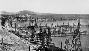
By 1895, wooden derricks had sprouted across the beaches and bluffs of Summerland
, completely changing the character of the community. Founded in 1889, originally the town had been a spiritualist
community consisting of a cluster of small houses around a central building in which seance
s were held. H.L. Williams, the founder of the town, had sold lots for $25 each, bringing in many people from outside of the area to build small houses. Within a few years, those same lots were commanding prices up to $7,500 because of the seemingly unlimited quantities of oil that could be drawn from the ground. Prospectors recognized that the tar sheen in the surf, along with evidence of natural gas venting, indicated that the oil field extended offshore; they then began drilling not just on the beach but from piers through the shallow water into the sub-marine sediments. Drilled in 1896, these were the world's first offshore oil wells.
Seeing that the Southern Pacific Railroad
line ran along the blufftop through the oil field, John Treadwell, a mining engineer with that company, decided to try to power locomotives with the heavy oil from the field rather than coal, and to help with this enterprise built the largest of the wharves out into the ocean. Named the Treadwell Wharf, in 1900 this structure alone had 19 wells along its length, which reached 1230 feet (374.9 m) by 75 feet (22.9 m) wide. Summerland thereby became a convenient refueling stop for the trains running between the coastal cities. The train line was new then; the tracks between Santa Barbara and Los Angeles were only built in 1887, and the line did not reach San Francisco until 1901, around the time production was peaking at Summerland.
Development of the Summerland Field was not entirely without controversy, even in its earliest years. The boom from the first oil find was so spectacular that after the hundreds of wells already put in had begun to run dry, drillers attempted to expand their area of operations uncomfortably close to Santa Barbara. In the late 1890s, a crowd of vigilantes headed by Reginald Fernald, a local newspaper publisher, tore down a drilling rig erected on Miramar Beach itself (now adjacent to a luxury hotel).
The Summerland field had an early peak in production followed by a precipitous decline. A severe winter storm in 1903 destroyed many of the flimsy wooden derricks on the wharves and beach, and by 1906 most of the oil production had ended, leaving behind abandoned derricks, many of which stood for decades. Drillers discovered a new deeper pool in the field in 1929, in the Vaqueros Sandstone, at a depth of about 1400 feet (426.7 m), but the wells at that time were less numerous and obtrusive. Also in 1929, the Mesa Oil Field
was discovered, just about six miles (10 km) to the west of the Summerland field and within the city of Santa Barbara itself; the Vaqueros Sandstone was the oil-bearing unit there as well. Peak annual production for the onshore part of the Summerland field was actually in 1929, at 118,519 barrels, from the Vaqueros, but this too was soon exhausted. Production in the field ceased entirely in 1939, and the remaining abandoned structures – wharves and derricks and associated equipment – were removed. During the entire period of operation of the field, over 412 oil wells were drilled.
as the deeper pool of the onshore field, the Vaqueros Sandstone, but the API gravity of the oil was lower (35) allowing it to flow freely. This field was drilled from two oil platforms, Hilda and Hazel, erected in 1958 and 1960 respectively. Platform Hazel was the first platform in California to be constructed onshore and towed to the site by barges. Both were anchored to the sea floor, which was approximately 100 feet (30.5 m) underneath each platform. They produced a cumulative total of 27.6 million barrels of oil and 97.8 million cubic feet of natural gas before being demolished in 1996. Peak production from the Summerland Offshore field was in 1964, at almost 3.8 million barrels, but the cost to maintain the operation, combined with the diminishing returns from the field, and public sentiment opposing drilling in the Santa Barbara Channel – as these platforms were close to the site of the notorious 1969 oil spill
– led their operator, Chevron Corp., to shut them down.
While neither field is producing in the present day, periodic attempts have been made to find and cap leaking wells from the operations in the late 19th and early 20th century. In those early years of the petroleum industry, there was little to no regulation of operating practice, and abandoned wells were often filled with whatever was available – earth, wooden poles, old mattresses and other rubbish were commonly stuffed down the holes, but these methods are ineffective for long-term plugging of an oil well. Since petroleum migrates upwards from pressurized source regions, over time it will find any open pathways to the surface; in the case of natural gas, this can cause an explosion hazard. Modern well abandonment techniques involve cutting off a well casing well below ground surface and capping with concrete, forming a permanent seal. Between 1960 and 1968, eighty old wells were located and capped in an attempt to stop the slow leaking of oil into the ocean. More wells were located, cut, filled, and capped in 1975 and 1993.
Oil field
An oil field is a region with an abundance of oil wells extracting petroleum from below ground. Because the oil reservoirs typically extend over a large area, possibly several hundred kilometres across, full exploitation entails multiple wells scattered across the area...
in Santa Barbara County, California
Santa Barbara County, California
Santa Barbara County is a county located in the southern portion of the U.S. state of California, on the Pacific coast. As of 2010 the county had a population of 423,895. The county seat is Santa Barbara and the largest city is Santa Maria.-History:...
, about four miles (6 km) east of the city of Santa Barbara
Santa Barbara, California
Santa Barbara is the county seat of Santa Barbara County, California, United States. Situated on an east-west trending section of coastline, the longest such section on the West Coast of the United States, the city lies between the steeply-rising Santa Ynez Mountains and the Pacific Ocean...
, within and next to the unincorporated community of Summerland
Summerland, California
Summerland is a census-designated place in Santa Barbara County, California, United States. The population was 1,448 at the 2010 census, down from 1,545 at the 2000 census.The town includes a school and a Presbyterian Church...
. First developed in the 1890s, and richly productive in the early 20th century, the Summerland Oil Field was the location of the world's first offshore oil wells, drilled from piers in 1896. This field, which was the first significant field to be developed in Santa Barbara County, produced 3.18 million of barrels of oil during its 50-year lifespan, finally being abandoned in 1939-40. Another nearby oil field entirely offshore, discovered in 1957 and named the Summerland Offshore Oil Field, produced from two drilling platforms in the Santa Barbara Channel before being abandoned in 1996.
Setting
The formerly productive region of the Summerland Oil Field is on the coast of southern Santa Barbara County, about four miles (6 km) east of the city of Santa Barbara, and includes most of the town of Summerland, as well as adjacent parts of MontecitoMontecito, California
Montecito is an unincorporated community in Santa Barbara County, California. As a census-designated place, it had a population of 8,965 in 2010. This does not include areas such as Coast Village Road, that, while usually considered part of Montecito, are actually within the city limits of Santa...
. It covers an area of a bit more than a square mile – 740 acres (3 km²) – of which 380, a little more than half, is onshore.
The climate is Mediterranean
Mediterranean climate
A Mediterranean climate is the climate typical of most of the lands in the Mediterranean Basin, and is a particular variety of subtropical climate...
, with an equable temperature regime year-round, and most of the precipitation falling between October and April in the form of rain. Freezes are rare. Runoff is towards the ocean. Bluffs rise sharply behind the beach, but rather than having an extended plateau behind the bluffs, as is the case along much of the south coast of Santa Barbara County, the land rises with a moderate slope towards the Santa Ynez Mountains
Santa Ynez Mountains
The Santa Ynez Mountains are a portion of the Transverse Ranges, part of the Pacific Coast Ranges of the west coast of North America, and are one of the northernmost mountain ranges in Southern California.-Geography:...
. The town of Summerland is built on the coast-facing part of this hillside, taking advantage of the ocean view, with modern residential and commercial development covering long-abandoned oil wells. The offshore part of the main Summerland field was in shallow water adjacent to the beach, and was drilled from piers. A popular beach extends the length of the former oil field, immediately below the town, and a park – Lookout Park – sits atop the bluffs.
Summerland Offshore Oil Field is a separate field in the Santa Barbara Channel
Santa Barbara Channel
The Santa Barbara Channel is a portion of the Pacific Ocean which separates the mainland of California from the northern Channel Islands. It is generally south of the city of Santa Barbara, and west of the city of Ventura....
about one and a half miles offshore, but within the 3-mile limit
Tidelands
Tidelands are the territory between the high and low water tide line of sea coasts, and lands lying under the sea beyond the low-water limit of the tide, considered within the territorial waters of a nation. The United States Constitution does not specify whether ownership of these lands rests with...
inside of which oil leasing is subject to state rather than federal regulation. Two oil platform
Oil platform
An oil platform, also referred to as an offshore platform or, somewhat incorrectly, oil rig, is a lаrge structure with facilities to drill wells, to extract and process oil and natural gas, and to temporarily store product until it can be brought to shore for refining and marketing...
s, named Hilda and Hazel, formerly stood on this field; Chevron Corp. dismantled them in 1996 and production from this field ended. The Carpinteria Offshore Oil Field
Carpinteria Offshore Oil Field
The Carpinteria Offshore Oil Field is an oil and gas field in Santa Barbara Channel, south of the city of Carpinteria in southern California in the United States...
, about four miles (6 km) to the southeast, also once contained a pair of platforms dismantled that same year, and its three remaining platforms outside the 3 miles (4.8 km) limit are visible from the shore at Summerland.
Geology
The Summerland field is contained in a series of sedimentary rockSedimentary rock
Sedimentary rock are types of rock that are formed by the deposition of material at the Earth's surface and within bodies of water. Sedimentation is the collective name for processes that cause mineral and/or organic particles to settle and accumulate or minerals to precipitate from a solution....
units in a trough known as the Carpinteria Basin. Oil is trapped in the Pleistocene
Pleistocene
The Pleistocene is the epoch from 2,588,000 to 11,700 years BP that spans the world's recent period of repeated glaciations. The name pleistocene is derived from the Greek and ....
-age Casitas Formation underneath impermeable sediments, although petroleum regularly makes its way to the surface in the form of asphalt seeps, here as elsewhere on the south coast of Santa Barbara County. Another unit underneath the Casitas Formation, the Oligocene
Oligocene
The Oligocene is a geologic epoch of the Paleogene Period and extends from about 34 million to 23 million years before the present . As with other older geologic periods, the rock beds that define the period are well identified but the exact dates of the start and end of the period are slightly...
-age Vaqueros Sandstone, also has considerable quantities of petroleum, with the capping unit being the impermeable Miocene
Miocene
The Miocene is a geological epoch of the Neogene Period and extends from about . The Miocene was named by Sir Charles Lyell. Its name comes from the Greek words and and means "less recent" because it has 18% fewer modern sea invertebrates than the Pliocene. The Miocene follows the Oligocene...
-age Rincon Formation
Rincon Formation
The Rincon Formation is a sedimentary geologic unit of Lower Miocene age, abundant in the coastal portions of southern Santa Barbara County, California eastward into Ventura County...
.
Oil in the Casitas Formation is shallow, at an average depth of only 140 feet (42.7 m), accounting for its early discovery and easy exploitation. In the Vaqueros formation the average depth to oil is 1400 feet (426.7 m) in the main Summerland field, and 7000 feet (2,133.6 m) in the Summerland Offshore field.
History, operations, and production
Tomol
Tomols are plank-built boats, historically and currently used by the Chumash and Tongva Native Americans in the Santa Barbara and Los Angeles area. They were also called tii'at by the Tongva. Tomols are long. They were especially important as both tribes relied on the sea for...
s, the watercraft with which they skilfully navigated the Santa Barbara Channel
Santa Barbara Channel
The Santa Barbara Channel is a portion of the Pacific Ocean which separates the mainland of California from the northern Channel Islands. It is generally south of the city of Santa Barbara, and west of the city of Ventura....
. Sometime before 1894, enterprising petroleum prospectors recognized the likelihood that economically viable deposits of oil and gas were the source for these seeps, and began digging. The first finds of petroleum were extremely heavy oil – API gravity
API gravity
The American Petroleum Institute gravity, or API gravity, is a measure of how heavy or light a petroleum liquid is compared to water. If its API gravity is greater than 10, it is lighter and floats on water; if less than 10, it is heavier and sinks...
of 7, so essentially asphalt
Asphalt
Asphalt or , also known as bitumen, is a sticky, black and highly viscous liquid or semi-solid that is present in most crude petroleums and in some natural deposits, it is a substance classed as a pitch...
– but undeterred, they continued searching for more marketable oil. The earliest known oil well in the vicinity of Summerland dates from 1886, and was drilled on the side of Ortega Hill, the topographic prominence just west of Summerland. While the well failed to produce marketable quantities of oil, it showed that there were indeed petroleum-bearing strata only several hundred feet below ground surface – well within the reach of late 19th-century drilling techology.
By 1895, wooden derricks had sprouted across the beaches and bluffs of Summerland
Summerland, California
Summerland is a census-designated place in Santa Barbara County, California, United States. The population was 1,448 at the 2010 census, down from 1,545 at the 2000 census.The town includes a school and a Presbyterian Church...
, completely changing the character of the community. Founded in 1889, originally the town had been a spiritualist
Spiritualism
Spiritualism is a belief system or religion, postulating the belief that spirits of the dead residing in the spirit world have both the ability and the inclination to communicate with the living...
community consisting of a cluster of small houses around a central building in which seance
Séance
A séance is an attempt to communicate with spirits. The word "séance" comes from the French word for "seat," "session" or "sitting," from the Old French "seoir," "to sit." In French, the word's meaning is quite general: one may, for example, speak of "une séance de cinéma"...
s were held. H.L. Williams, the founder of the town, had sold lots for $25 each, bringing in many people from outside of the area to build small houses. Within a few years, those same lots were commanding prices up to $7,500 because of the seemingly unlimited quantities of oil that could be drawn from the ground. Prospectors recognized that the tar sheen in the surf, along with evidence of natural gas venting, indicated that the oil field extended offshore; they then began drilling not just on the beach but from piers through the shallow water into the sub-marine sediments. Drilled in 1896, these were the world's first offshore oil wells.
Seeing that the Southern Pacific Railroad
Southern Pacific Railroad
The Southern Pacific Transportation Company , earlier Southern Pacific Railroad and Southern Pacific Company, and usually simply called the Southern Pacific or Espee, was an American railroad....
line ran along the blufftop through the oil field, John Treadwell, a mining engineer with that company, decided to try to power locomotives with the heavy oil from the field rather than coal, and to help with this enterprise built the largest of the wharves out into the ocean. Named the Treadwell Wharf, in 1900 this structure alone had 19 wells along its length, which reached 1230 feet (374.9 m) by 75 feet (22.9 m) wide. Summerland thereby became a convenient refueling stop for the trains running between the coastal cities. The train line was new then; the tracks between Santa Barbara and Los Angeles were only built in 1887, and the line did not reach San Francisco until 1901, around the time production was peaking at Summerland.
Development of the Summerland Field was not entirely without controversy, even in its earliest years. The boom from the first oil find was so spectacular that after the hundreds of wells already put in had begun to run dry, drillers attempted to expand their area of operations uncomfortably close to Santa Barbara. In the late 1890s, a crowd of vigilantes headed by Reginald Fernald, a local newspaper publisher, tore down a drilling rig erected on Miramar Beach itself (now adjacent to a luxury hotel).
The Summerland field had an early peak in production followed by a precipitous decline. A severe winter storm in 1903 destroyed many of the flimsy wooden derricks on the wharves and beach, and by 1906 most of the oil production had ended, leaving behind abandoned derricks, many of which stood for decades. Drillers discovered a new deeper pool in the field in 1929, in the Vaqueros Sandstone, at a depth of about 1400 feet (426.7 m), but the wells at that time were less numerous and obtrusive. Also in 1929, the Mesa Oil Field
Mesa Oil Field
The Mesa Oil Field is an abandoned oil field entirely within the city limits of Santa Barbara, California, in the United States. Discovered in 1929, it was quickly developed and quickly declined, as it proved to be but a relatively small accumulation of oil in a single geologic formation...
was discovered, just about six miles (10 km) to the west of the Summerland field and within the city of Santa Barbara itself; the Vaqueros Sandstone was the oil-bearing unit there as well. Peak annual production for the onshore part of the Summerland field was actually in 1929, at 118,519 barrels, from the Vaqueros, but this too was soon exhausted. Production in the field ceased entirely in 1939, and the remaining abandoned structures – wharves and derricks and associated equipment – were removed. During the entire period of operation of the field, over 412 oil wells were drilled.
Summerland Offshore Oil Field
The Summerland Offshore Oil Field – distinct from the offshore portion of the main Summerland field, as it was more than a mile from shore – was not discovered until 1957. Its oil was from the same source rockSource rock
In petroleum geology, source rock refers to rocks from which hydrocarbons have been generated or are capable of being generated. They form one of the necessary elements of a working petroleum system. They are organic-rich sediments that may have been deposited in a variety of environments including...
as the deeper pool of the onshore field, the Vaqueros Sandstone, but the API gravity of the oil was lower (35) allowing it to flow freely. This field was drilled from two oil platforms, Hilda and Hazel, erected in 1958 and 1960 respectively. Platform Hazel was the first platform in California to be constructed onshore and towed to the site by barges. Both were anchored to the sea floor, which was approximately 100 feet (30.5 m) underneath each platform. They produced a cumulative total of 27.6 million barrels of oil and 97.8 million cubic feet of natural gas before being demolished in 1996. Peak production from the Summerland Offshore field was in 1964, at almost 3.8 million barrels, but the cost to maintain the operation, combined with the diminishing returns from the field, and public sentiment opposing drilling in the Santa Barbara Channel – as these platforms were close to the site of the notorious 1969 oil spill
1969 Santa Barbara oil spill
The Santa Barbara oil spill occurred in January and February 1969 in the Santa Barbara Channel, near the city of Santa Barbara in Southern California. It was the largest oil spill in United States waters at the time, and now ranks third after the 2010 Deepwater Horizon and 1989 Exxon Valdez spills...
– led their operator, Chevron Corp., to shut them down.
While neither field is producing in the present day, periodic attempts have been made to find and cap leaking wells from the operations in the late 19th and early 20th century. In those early years of the petroleum industry, there was little to no regulation of operating practice, and abandoned wells were often filled with whatever was available – earth, wooden poles, old mattresses and other rubbish were commonly stuffed down the holes, but these methods are ineffective for long-term plugging of an oil well. Since petroleum migrates upwards from pressurized source regions, over time it will find any open pathways to the surface; in the case of natural gas, this can cause an explosion hazard. Modern well abandonment techniques involve cutting off a well casing well below ground surface and capping with concrete, forming a permanent seal. Between 1960 and 1968, eighty old wells were located and capped in an attempt to stop the slow leaking of oil into the ocean. More wells were located, cut, filled, and capped in 1975 and 1993.