
Jesusita Fire
Encyclopedia
Santa Barbara, California
Santa Barbara is the county seat of Santa Barbara County, California, United States. Situated on an east-west trending section of coastline, the longest such section on the West Coast of the United States, the city lies between the steeply-rising Santa Ynez Mountains and the Pacific Ocean...
. The fire burned 8733 acres (35.3 km²), destroyed 80 homes and damaged 15 more before being 100% contained.
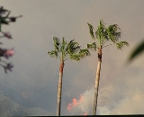
On May 8, 2009, the fire perimeter extended from west of Highway 154, in the hills burned in the 1990 Painted Cave Fire, across the front country of the Santa Ynez Mountains
Santa Ynez Mountains
The Santa Ynez Mountains are a portion of the Transverse Ranges, part of the Pacific Coast Ranges of the west coast of North America, and are one of the northernmost mountain ranges in Southern California.-Geography:...
east through Mission Canyon, Rattlesnake Canyon, and into the hills above Montecito
Montecito, California
Montecito is an unincorporated community in Santa Barbara County, California. As a census-designated place, it had a population of 8,965 in 2010. This does not include areas such as Coast Village Road, that, while usually considered part of Montecito, are actually within the city limits of Santa...
, reaching the area burned by the Goleta Gap Fire in July 2008 and the Montecito Tea Fire
Montecito Tea Fire
The Montecito Tea Fire is a wildfire that began on November 13, 2008, destroying 210 homes in the cities of Montecito and Santa Barbara, California in the United States of America. It was the first of several November 2008 wildfires that burned hundreds of homes November 13–15, 2008...
in November 2008. Intense sundowner wind
Sundowner (wind)
A sundowner is an offshore northerly Foehn wind in Santa Barbara, California. It occurs when a region of high pressure is directly north of the area, whose coast trends east–west. This contrasts with the more typical onshore flow...
s caused the fire to spread rapidly during evening and nighttime hours during its first three days.
Cause
As of May 9, 2009, the cause of the fire is thought to be related to the use of a power tool near Jesusita trail. The individual(s) responsible is still unidentified.Evacuations
All mandatory evacuation orders connected with the fire were lifted as of May 13, 2009.As of May 9, 2009, approximately 5,894 properties were under mandatory evacuation orders, affecting an estimated 14,735 people. In addition, more than 17,787 properties were under evacuation warning, affecting an estimated 44,467 people. Red Cross had shelters for evacuees at the Multi-Activity Court at the UCSB
University of California, Santa Barbara
The University of California, Santa Barbara, commonly known as UCSB or UC Santa Barbara, is a public research university and one of the 10 general campuses of the University of California system. The main campus is located on a site in Goleta, California, from Santa Barbara and northwest of Los...
Recreational Center. From May 5 to May 9, 2009, evacuees were also sheltered at San Marcos High School
San Marcos High School
San Marcos High School is a public high school located near the Southern California city of Santa Barbara, United States. It is under the governance of the Santa Barbara School Districts, and has an enrollment of approximately 2200 students in Grades 9-12. San Marcos High School was founded in...
in Goleta
Goleta, California
Goleta is a city in southern Santa Barbara County, California, USA. It was incorporated as a city in 2002, after a long period as the largest unincorporated, populated area in the county. As of the 2000 census, the Census-designated place had a total population of 55,204, however, a significant...
.
Injuries
As of May 11, 2009, there were 28 injuries.Destruction of property
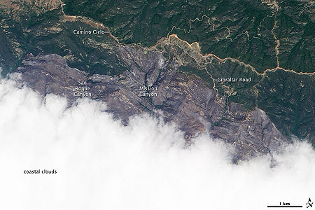
Much of the Santa Barbara Botanic GardenSanta Barbara Botanic Garden
The Santa Barbara Botanic Garden is a 26 ha garden, containing over 1,000 species of rare and indigenous plants. It is located in Mission Canyon, Santa Barbara, California, USA....
was destroyed on the night of May 7..
The current cost of the fire is estimated at $20 million.
External links
- Erosion Control Resources for Santa Barbara Fire Victims
- VGI Map Referenced by the County
- Los Angeles Times' Google map of evacuation areas, road closures, and damaged homes
- http://www.flickr.com/photos/docsearls/sets/72157617805053362/Set of Google Maps enhanced by MODISMODISThe Moderate-resolution Imaging Spectroradiometer is a payload scientific instrument launched into Earth orbit by NASA in 1999 on board the Terra Satellite, and in 2002 on board the Aqua satellite...
, which reads fire/heat by satellite, and video by helicopter from KSBY TV.], by Doc SearlsDoc SearlsDavid "Doc" Searls , co-author of The Cluetrain Manifesto, is an American journalist, columnist, author and a widely-read blogger, a fellow at the Center for Information Technology & Society at the University of California, Santa Barbara, and a fellow alumnus of the Berkman Center for Internet &... - Time-lapse photos of fire, by a local resident (and evacuee)
- Jesusita Fire Burn Scar, from NASA Earth Observatory
- County of Santa Barbara website with Jesusita Fire information
- Santa Barbara Independent news coverage
- Jesusita burn area of 10,104 acres mapped by GeoVAR using 3D terrain.