
Mission Canyon, California
Encyclopedia
Mission Canyon is a census-designated place
and an unincorporated suburb of Santa Barbara, California
, in Santa Barbara County
, United States
. The population was 2,381 at the 2010 census, down from 2,610 at the 2000 census.
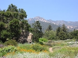
Mission Canyon is directly north — on the mountain side — of the city of Santa Barbara, and derives its name from the Mission Santa Barbara
which is built between Mission Canyon and the center of the city. The canyon itself is one of the most dramatic in the Santa Ynez Mountains
, with the locally highest peak (La Cumbre Peak
, 3985') at the top of the watershed, and rugged sandstone
formations, partially covered with chaparral
, on both sides of the creek.
State Route 192 (Foothill Road) bisects the southern portion of the area, running from east to west, and Mission Canyon Road passes through the area from north to south. Another major north-south artery is Tunnel Road, which leads to the trailhead for several popular hiking trails that start at the northern extremity of the urbanized area; these trails lead up into the mountains.
The Santa Barbara Botanic Garden
is located in Mission Canyon.
 The approximate center of Mission Canyon is located at 34°26′59"N 119°42′59"W (34.449797, -119.716315).
According to the United States Census Bureau
, the CDP has a total area of 1.5 square miles (3.9 km²), of which 1.5 square miles (3.9 km²) are land and 0.03 square mile (0.0776996433 km²) (1.94%) is water.
was 1,538.8 people per square mile (594.1/km²). The racial makeup of Mission Canyon was 2,193 (92.1%) White, 14 (0.6%) African American, 17 (0.7%) Native American, 40 (1.7%) Asian, 11 (0.5%) Pacific Islander, 35 (1.5%) from other races
, and 71 (3.0%) from two or more races. Hispanic or Latino of any race were 198 persons (8.3%).
The Census reported that 2,372 people (99.6% of the population) lived in households, 0 (0%) lived in non-institutionalized group quarters, and 9 (0.4%) were institutionalized.
There were 1,020 households, out of which 230 (22.5%) had children under the age of 18 living in them, 547 (53.6%) were opposite-sex married couples
living together, 59 (5.8%) had a female householder with no husband present, 20 (2.0%) had a male householder with no wife present. There were 59 (5.8%) unmarried opposite-sex partnerships
, and 14 (1.4%) same-sex married couples or partnerships. 264 households (25.9%) were made up of individuals and 97 (9.5%) had someone living alone who was 65 years of age or older. The average household size was 2.33. There were 626 families
(61.4% of all households); the average family size was 2.70.
The population was spread out with 368 people (15.5%) under the age of 18, 100 people (4.2%) aged 18 to 24, 458 people (19.2%) aged 25 to 44, 973 people (40.9%) aged 45 to 64, and 482 people (20.2%) who were 65 years of age or older. The median age was 51.3 years. For every 100 females there were 95.5 males. For every 100 females age 18 and over, there were 97.0 males.
There were 1,075 housing units at an average density of 694.7 per square mile (268.2/km²), of which 782 (76.7%) were owner-occupied, and 238 (23.3%) were occupied by renters. The homeowner vacancy rate was 0.8%; the rental vacancy rate was 4.4%. 1,828 people (76.8% of the population) lived in owner-occupied housing units and 544 people (22.8%) lived in rental housing units.
of 2000, there were 2,610 people, 1,065 households, and 689 families residing in the CDP. The population density
was 1,663.6 people per square mile (641.9/km²). There were 1,115 housing units at an average density of 710.7 per square mile (274.2/km²). The racial makeup of the CDP was 93.64% White, 0.42% African American, 0.15% Native American, 1.30% Asian, 0.04% Pacific Islander, 2.18% from other races
, and 2.26% from two or more races. Hispanic or Latino of any race were 6.63% of the population.
There were 1,065 households out of which 23.5% had children under the age of 18 living with them, 52.6% were married couples
living together, 8.1% had a female householder with no husband present, and 35.3% were non-families. 22.3% of all households were made up of individuals and 6.1% had someone living alone who was 65 years of age or older. The average household size was 2.44 and the average family size was 2.73.
In the CDP the population was spread out with 16.9% under the age of 18, 5.0% from 18 to 24, 27.8% from 25 to 44, 35.4% from 45 to 64, and 14.9% who were 65 years of age or older. The median age was 45 years. For every 100 females there were 93.2 males. For every 100 females age 18 and over, there were 93.4 males.
The median income for a household in the CDP was $79,338, and the median income for a family was $103,442. Males had a median income of $57,222 versus $41,131 for females. The per capita income
for the CDP was $43,422. About 1.0% of families and 6.8% of the population were below the poverty line, including 1.6% of those under age 18 and 7.4% of those age 65 or over.
Census-designated place
A census-designated place is a concentration of population identified by the United States Census Bureau for statistical purposes. CDPs are delineated for each decennial census as the statistical counterparts of incorporated places such as cities, towns and villages...
and an unincorporated suburb of Santa Barbara, California
Santa Barbara, California
Santa Barbara is the county seat of Santa Barbara County, California, United States. Situated on an east-west trending section of coastline, the longest such section on the West Coast of the United States, the city lies between the steeply-rising Santa Ynez Mountains and the Pacific Ocean...
, in Santa Barbara County
Santa Barbara County, California
Santa Barbara County is a county located in the southern portion of the U.S. state of California, on the Pacific coast. As of 2010 the county had a population of 423,895. The county seat is Santa Barbara and the largest city is Santa Maria.-History:...
, United States
United States
The United States of America is a federal constitutional republic comprising fifty states and a federal district...
. The population was 2,381 at the 2010 census, down from 2,610 at the 2000 census.
Mission Canyon is directly north — on the mountain side — of the city of Santa Barbara, and derives its name from the Mission Santa Barbara
Mission Santa Barbara
In 1840, Alta California and Baja California were removed from the Diocese of Sonora to form the Diocese of Both Californias. Bishop Francisco Garcia Diego y Moreno, OFM, established his cathedra at Mission Santa Barbara, making the chapel the pro-cathedral of the diocese until 1849...
which is built between Mission Canyon and the center of the city. The canyon itself is one of the most dramatic in the Santa Ynez Mountains
Santa Ynez Mountains
The Santa Ynez Mountains are a portion of the Transverse Ranges, part of the Pacific Coast Ranges of the west coast of North America, and are one of the northernmost mountain ranges in Southern California.-Geography:...
, with the locally highest peak (La Cumbre Peak
La Cumbre Peak
La Cumbre Peak is a 3,995 foot peak in the Santa Ynez Mountains north of Santa Barbara, California. Made up of boulders and slabs of the Matilija Sandstone amid groves of pine trees, it is the highest summit near to the city...
, 3985') at the top of the watershed, and rugged sandstone
Sandstone
Sandstone is a sedimentary rock composed mainly of sand-sized minerals or rock grains.Most sandstone is composed of quartz and/or feldspar because these are the most common minerals in the Earth's crust. Like sand, sandstone may be any colour, but the most common colours are tan, brown, yellow,...
formations, partially covered with chaparral
Chaparral
Chaparral is a shrubland or heathland plant community found primarily in the U.S. state of California and in the northern portion of the Baja California peninsula, Mexico...
, on both sides of the creek.
State Route 192 (Foothill Road) bisects the southern portion of the area, running from east to west, and Mission Canyon Road passes through the area from north to south. Another major north-south artery is Tunnel Road, which leads to the trailhead for several popular hiking trails that start at the northern extremity of the urbanized area; these trails lead up into the mountains.
The Santa Barbara Botanic Garden
Santa Barbara Botanic Garden
The Santa Barbara Botanic Garden is a 26 ha garden, containing over 1,000 species of rare and indigenous plants. It is located in Mission Canyon, Santa Barbara, California, USA....
is located in Mission Canyon.
Geography
According to the United States Census Bureau
United States Census Bureau
The United States Census Bureau is the government agency that is responsible for the United States Census. It also gathers other national demographic and economic data...
, the CDP has a total area of 1.5 square miles (3.9 km²), of which 1.5 square miles (3.9 km²) are land and 0.03 square mile (0.0776996433 km²) (1.94%) is water.
2010
The 2010 United States Census reported that Mission Canyon had a population of 2,381. The population densityPopulation density
Population density is a measurement of population per unit area or unit volume. It is frequently applied to living organisms, and particularly to humans...
was 1,538.8 people per square mile (594.1/km²). The racial makeup of Mission Canyon was 2,193 (92.1%) White, 14 (0.6%) African American, 17 (0.7%) Native American, 40 (1.7%) Asian, 11 (0.5%) Pacific Islander, 35 (1.5%) from other races
Race (United States Census)
Race and ethnicity in the United States Census, as defined by the Federal Office of Management and Budget and the United States Census Bureau, are self-identification data items in which residents choose the race or races with which they most closely identify, and indicate whether or not they are...
, and 71 (3.0%) from two or more races. Hispanic or Latino of any race were 198 persons (8.3%).
The Census reported that 2,372 people (99.6% of the population) lived in households, 0 (0%) lived in non-institutionalized group quarters, and 9 (0.4%) were institutionalized.
There were 1,020 households, out of which 230 (22.5%) had children under the age of 18 living in them, 547 (53.6%) were opposite-sex married couples
Marriage
Marriage is a social union or legal contract between people that creates kinship. It is an institution in which interpersonal relationships, usually intimate and sexual, are acknowledged in a variety of ways, depending on the culture or subculture in which it is found...
living together, 59 (5.8%) had a female householder with no husband present, 20 (2.0%) had a male householder with no wife present. There were 59 (5.8%) unmarried opposite-sex partnerships
POSSLQ
POSSLQ is an abbreviation for "Persons of Opposite Sex Sharing Living Quarters," a term coined in the late 1970s by the United States Census Bureau as part of an effort to more accurately gauge the prevalence of cohabitation in American households....
, and 14 (1.4%) same-sex married couples or partnerships. 264 households (25.9%) were made up of individuals and 97 (9.5%) had someone living alone who was 65 years of age or older. The average household size was 2.33. There were 626 families
Family (U.S. Census)
A family or family household is defined by the United States Census Bureau for statistical purposes as "a householder and one or more other people related to the householder by birth, marriage, or adoption. They do not include same-sex married couples even if the marriage was performed in a state...
(61.4% of all households); the average family size was 2.70.
The population was spread out with 368 people (15.5%) under the age of 18, 100 people (4.2%) aged 18 to 24, 458 people (19.2%) aged 25 to 44, 973 people (40.9%) aged 45 to 64, and 482 people (20.2%) who were 65 years of age or older. The median age was 51.3 years. For every 100 females there were 95.5 males. For every 100 females age 18 and over, there were 97.0 males.
There were 1,075 housing units at an average density of 694.7 per square mile (268.2/km²), of which 782 (76.7%) were owner-occupied, and 238 (23.3%) were occupied by renters. The homeowner vacancy rate was 0.8%; the rental vacancy rate was 4.4%. 1,828 people (76.8% of the population) lived in owner-occupied housing units and 544 people (22.8%) lived in rental housing units.
2000
As of the censusCensus
A census is the procedure of systematically acquiring and recording information about the members of a given population. It is a regularly occurring and official count of a particular population. The term is used mostly in connection with national population and housing censuses; other common...
of 2000, there were 2,610 people, 1,065 households, and 689 families residing in the CDP. The population density
Population density
Population density is a measurement of population per unit area or unit volume. It is frequently applied to living organisms, and particularly to humans...
was 1,663.6 people per square mile (641.9/km²). There were 1,115 housing units at an average density of 710.7 per square mile (274.2/km²). The racial makeup of the CDP was 93.64% White, 0.42% African American, 0.15% Native American, 1.30% Asian, 0.04% Pacific Islander, 2.18% from other races
Race (United States Census)
Race and ethnicity in the United States Census, as defined by the Federal Office of Management and Budget and the United States Census Bureau, are self-identification data items in which residents choose the race or races with which they most closely identify, and indicate whether or not they are...
, and 2.26% from two or more races. Hispanic or Latino of any race were 6.63% of the population.
There were 1,065 households out of which 23.5% had children under the age of 18 living with them, 52.6% were married couples
Marriage
Marriage is a social union or legal contract between people that creates kinship. It is an institution in which interpersonal relationships, usually intimate and sexual, are acknowledged in a variety of ways, depending on the culture or subculture in which it is found...
living together, 8.1% had a female householder with no husband present, and 35.3% were non-families. 22.3% of all households were made up of individuals and 6.1% had someone living alone who was 65 years of age or older. The average household size was 2.44 and the average family size was 2.73.
In the CDP the population was spread out with 16.9% under the age of 18, 5.0% from 18 to 24, 27.8% from 25 to 44, 35.4% from 45 to 64, and 14.9% who were 65 years of age or older. The median age was 45 years. For every 100 females there were 93.2 males. For every 100 females age 18 and over, there were 93.4 males.
The median income for a household in the CDP was $79,338, and the median income for a family was $103,442. Males had a median income of $57,222 versus $41,131 for females. The per capita income
Per capita income
Per capita income or income per person is a measure of mean income within an economic aggregate, such as a country or city. It is calculated by taking a measure of all sources of income in the aggregate and dividing it by the total population...
for the CDP was $43,422. About 1.0% of families and 6.8% of the population were below the poverty line, including 1.6% of those under age 18 and 7.4% of those age 65 or over.