

San Mateo Creek (Southern California)
Encyclopedia
San Mateo Creek is a stream in Southern
California
in the United States
, whose watershed mostly straddles the border of Orange
and San Diego Counties. It is about 22 miles (35.4 km) long, flowing in a generally southwesterly direction. Draining a broad valley bounded by the Santa Ana Mountains
and Santa Margarita Mountains
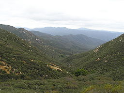
, San Mateo Creek is notable for being one of the last unchannelized streams in Southern California.
One of the most undeveloped watersheds on the South Coast, San Mateo Creek's drainage basin covers 139 mi2 in parts of the Cleveland National Forest
and Marine Corps Base Camp Pendleton
. The first inhabitants were Native Americans primarily of the Luiseño group, followed by the Spanish who established rancho
s in the area. The creek's usually perennial flow made it an important source of irrigation water, then in the later 19th century, there was a gold rush
in the upper watershed. Most of the little development in the watershed is now agriculture
-based.
The San Mateo Creek watershed includes the subwatersheds of Talega, Tenaja, Gabino and Cristianitos Canyon. Although grazing
activities have hurt the biological quality of the semi-arid
, Mediterranean
-climate watershed, it still supports numerous biological communities including riparian zone
s, grassland
and coastal sage scrub
. A population of steelhead trout has recently been identified in the creek, which is slightly affected by minor agricultural runoff.
, which lie mostly in Orange County. From there, the creek continues through a steep and narrow gorge for the first part of its course, then a broad and shallower valley for the second part. It receives four major tributaries
and many smaller ones on its generally southwest journey to the Pacific Ocean.
From its headwaters near Lake Elsinore
inside the Cleveland National Forest, San Mateo Creek runs southwards through a canyon that widens and deepens until it is roughly 600 feet (182.9 m) in depth. It then turns southwest, cutting between the Santa Ana and Santa Margarita Mountains in an arid canyon surrounded by slopes dissected by many side canyons. At river mile
(RM) 18 or river kilometer (RK) 28.9, Tenaja Creek, which flows generally northwest, comes in from the left. Shortly after, at RM 17.5 (RK 28.1) Bluewater Canyon merges with San Mateo Canyon from the right.
The creek then continues to flow southwards and Cold Spring Creek comes in from the left at RM 15 (RK 24.1). The Cold Spring Creek confluence approximately marks the point where San Mateo Creek leaves the Cleveland National Forest. Soon, the narrow 2500 feet (762 m)-deep canyon gives way to a broad alluvial valley. San Mateo Creek flows past Camp Pendleton, a United States Marine Corps
amphibious training base. At RM 3.7 (RK 5.95) Cristianitos Canyon, the largest tributary, joins from the right. Cristianitos Canyon begins in extreme southeastern Orange County and drains about 29 mi2.
San Mateo Creek then crosses under Interstate 5
and empties into a small, perennial freshwater lagoon
bounded by a sandbar at San Onofre State Beach. The lagoon only empties into the sea during the rainy season. This portion of the creek is very close to San Clemente
and a small residential area is just to the northeast side of the lagoon. The lagoon remains similar to its natural state as well, although it is increasingly becoming harmed by unnatural pollutants.
, whose underlying bedrock consists of Jurassic
-age igneous and sedimentary rock, overlain by a few thousand vertical feet of Cretaceous
-age granite
, gabbro
, and tolamite. Underneath the San Mateo Creek valley's several hundred feet of alluvial deposits, there are layers of sandstone
, limestone
, siltstone
, mudstone
, shale
and conglomerate
. These formations are present along most of the streams draining off the west slope of the Santa Ana Mountains and are practically identical as far north as Santiago Creek
, which is in north-central Orange County nearly 50 miles (80.5 km) away.
The alluvial deposits originate from the Wisconsinian glaciation, in which massive glaciers and ice sheets advanced over much of North America
and shifted the global climate. During this roughly 60,000 year long period that ended in approximately 8000 B.C., Southern California
received up to 80 inches (2,032 mm) of rainfall per year, and this radical climate change coincided with a 300 to 400 ft (91.4 to 121.9 m) drop in sea level
. As the sea levels fell, streams flowing into the Pacific from Southern California began to erode massive canyons in their floodplain
s.
The rivers eventually eroded to 400 feet (121.9 m) or so below their previous elevation. When the Wisconsinian period ended, sea level rose, filled these canyons and turned them into long, narrow inlets. Because the heavy rains ceased with the departure of the Wisconsinian, the rivers and streams once again became slow-flowing. Over the course of thousands of years, these calm inlets gradually filled with alluvial sediments, giving them the flat valley floors they have today. Over time, sea level dropped slightly again, allowing the rivers to once again entrench channels into their floodplains, resulting in the broad river terraces that line much of lower San Mateo Creek, Arroyo San Onofre and San Juan Creek
.
y, well-drained and also fertile in the lowlands. In the mountains the soil cover is very shallow and there are many exposed cliffs, large boulders and outcroppings of sedimentary rock. In the lower watershed are sandy or silty loams which have a clay
substructure. These soils are classified as highly fertile and there are a few farms on the foothills and the floodplain of the San Mateo Creek watershed.
 The San Mateo Creek drainage basin
covers 139 mi2 mostly in San Diego County and partially in Orange County
. It shares boundaries with several watersheds—including Segunda Deshecha Cañada to the west, Arroyo San Onofre to the southeast, and streams draining into Lake Elsinore
in the northeast. It is slightly larger than the 133.9 mi2 San Juan Creek
watershed, which borders on the San Mateo Creek watershed's northeastern side.
The upper reaches of the watershed consist primarily of canyons that are 200 to 2500 ft (61 to 762 m) deep and 0.5 to 1 mi (0.80467 to 1.6 km) broad, while the lower watershed is a valley 2.5 to 3 mi (4 to 4.8 km) wide and less than 1000 feet (304.8 m) deep. The largest tributary of San Mateo Creek is Cristianitos Canyon (or Christianitos Canyon), which is about 10 miles (16.1 km) long and drains 29 mi2 in the western portion of the watershed with a portion in Orange County. Other significant sub-basins in the watershed include Talega Canyon, La Paz Creek and Gabino Creek, all of which are tributaries of Cristianitos Canyon.
The Santa Ana Mountains
form the drainage divide with San Juan Creek on the northwest side of the San Mateo Creek valley, and the Santa Margarita Mountains
on the southeast separate San Mateo Creek from the Arroyo San Onofre, a creek that drains westwards to the Pacific Ocean. Arroyo San Onofre is also the closest major stream to San Mateo Creek by location of the mouth. The next closest is Segunda Deshecha Cañada, further north. Much of the upper San Mateo Creek watershed is encompassed by the central Cleveland National Forest and the lower lies mostly within Camp Pendleton. The closest city is San Clemente
, northwest of the creek's mouth.
San Mateo Creek was once a seasonal stream that would flow through the rainy season, run dry by June or July and restart in October. Although springs exist in the mountains, once the creek spilled onto its floodplain, it would seep into the ground and run in a subsurface manner. Irrigation return flows and a sewage treatment plant have increased its flows to perennial, although it does not receive as much runoff as most other Southern California streams. The typical annual peak flow is around 2760 cuft/s, while the 2-year flood is 3200 cuft/s, the 10-year event, 19160 cuft/s, and the 100-year flood
, 47530 cuft/s.
s and woodland
s around the perennial or semi-perennial streams, grassland
on the valley floors, and chaparral
and coastal sage scrub
on the hillsides. Overall the vegetation groups and their distribution are very similar to that of San Juan Creek and its major tributary, Trabuco Creek
, in the northwest. The major difference is that the San Mateo Creek watershed contains no major residential areas.
The mouth of the creek and its last reaches shortly above and below Camp Pendleton are host to a wide variety of riparian plants. At the mouth, there is a freshwater lagoon and several freshwater marshes, surrounded by a riparian woodland consisting primarily of willow
, sycamore
, live oak
and cottonwood. Surrounding the lower San Mateo Creek valley and on the shallow slopes is the coastal sage scrub community, which consist primarily of coast goldenbush
, coyote brush
, California sagebrush
, mulefat
, toyon, poison oak, laurel sumac
, California mugwort
, Mexican elderberry, and California encelia
. At the very mouth, where groundwater
surfaces on the streambed, there are the stands of trees, and undergrowth includes wild cucumber
and gooseberry
.
Freshwater marshes surrounding San Mateo Creek exist in a strip just a few hundred feet wide and draw their water supply primarily from emerging groundwater. The most prominent plants are bulrush
, specifically California bulrush
, and cattail
. There are also several species of burweeds and fern
s, and on the edges of the marshes and on the surrounding small meadows, goldenrod
, hedge-nettle
, fleshy jaumea
, Mexican rush
, saltgrass, and iceplant.
in Los Angeles County to host this endanged species
.
Steelhead have historically spawned in the creek, whose upper reaches also support a population of rainbow trout
, the form taken by Oncorhyncus mykiss when it remains land-locked. There are about 11 miles (17.7 km) of streams in the watershed that provide suitable habitat for steelhead trout.
Significantly, DNA analysis has shown that San Mateo Creek steelhead are genetically native southern steelhead, and not hatchery stocked fish.
Steelhead in San Mateo Creek spawn primarily in the winter, when heavy storm runoff from the Santa Ana and Santa Margarita Mountains raises the creek's flow enough to breach the sandbar at San Onofre State Park
. In the few weeks or months following when there is still a substantial flow in the creek, the steelhead spawn and then the adults return to sea. In the dry months following the streams in the lowlands shrink to small pools that still support amphibian
s and small fish including steelhead fry which need to spend about one year in freshwater. Recently, steelhead have been sighted in the creek in greater numbers, bringing attention to coastal San Diego and Orange County streams.
Other fish and amphibian species in the watershed include the endangered tidewater goby
and arroyo toad
. Tidewater goby reside in small to medium-sized, brackish slough
s and marshes near the mouth of the creek. The watershed also has a number of birds; endangered species include the Least Bell's Vireo
(Vireo bellii pusillus), California Gnatcatcher
(Polioptila californica) and Willow Flycatcher
(Empidonax traillii).
In early February, 2010 a Golden beaver (Castor canadensis subauratus) was captured in a live trap by San Onofre State Beach officers who discovered the beaver at the river mouth of San Mateo Creek. According to State Parks officials, the species was once native to the San Mateo Creek watershed, but were thought to be extinct.
Beaver were also found in an ecological survey of the lagoon near the creek mouth in 1987.
A report on the fauna of the county by Dr. David Hoffman in 1866 stated "Of the animal kingdom we have a fair variety: the grizzly bear, the antelope, the deer, the polecat, the beaver, the wildcat, the otter, the fox, the badger, the hare, the squirrel, and coyotes innumerable."
The beaver may have accessed San Mateo Creek from the Santa Margarita River
watershed where Golden beaver were re-introduced around 1940. Indirect evidence of beaver in San Diego County includes a creek named Beaver Hollow which runs 3.25 miles into the Sweetwater River
about 6.5 miles southwest of Alpine
. Beaver Hollow is named on the USGS
Topo Map for Cuyamaca
in 1903, which is twenty years before California Department of Fish and Game
began beaver re-introductions in California.
lifestyle. Other Native American groups in the area included the Kumeyaay
, Luiseño
, Cahuella, and Capeño. The village of Panhe is estimated to have had a population of 300 or so before the first Spanish explorers came to the area, and is still a sacred site for the Native Americans.
The first Spanish explorers to have seen the creek were likely part ot the Gaspar de Portolá
expedition of 1769 to Monterey Bay
, whose members crossed the creek near its mouth on July 22 or 23. This group was responsible for giving the first European names to many of the creeks and canyons in the area, including San Juan Creek, Santiago Creek
, and Arroyo San Onofre, many of which stayed. After the construction of Mission San Juan Capistrano
near the present-day site of the city of the same name, the San Mateo Creek Valley was settled by the Spanish and extensively farmed and irrigated. These practices hurt the groundwater and hydrology of the area, which is slowly recovering.
By 1833, the Secularization Act passed by the newly independent country of Mexico brought an end to the mission period. Thousands of acres of land once owned by the missions now had no owners, so the land was split into large rancho
s. The 133441 acres (540 km²) Rancho Santa Margarita y Las Flores
was established in 1841 and granted to Pio and Andres Pico. They planted non-native crops, pumped water from the aquifer, and grazed cattle, severely damaging the grasslands and riparian habitat. By 1860, a discovery of gold
, zinc
, lead
and silver
in the upper San Mateo Creek watershed led American miners to the area. The rancho went through many hands and there were many conflicts with Native Americans before the U.S. Navy, in 1941, purchased most of the land for Camp Pendleton for around $6.5 million.
Recently a controversy has erupted over whether to extend California State Route 241
south through the lower San Mateo Creek valley to join Interstate 5
near the creek's mouth. The project was proposed to improve traffic flow on the Orange-San Diego County border. While proponents of the project claim that it will relieve congestion on the interstate and not affect the native habitat, opponents argue that the routing would increase sediment loads in the creek, damage the surf break at San Onofre State Beach, create water pollution and hurt several endangered animal species. The project prompted American Rivers to list San Mateo Creek as the "nation's second-most imperiled waterway".
No decision has been made on the project to date.
Southern California
Southern California is a megaregion, or megapolitan area, in the southern area of the U.S. state of California. Large urban areas include Greater Los Angeles and Greater San Diego. The urban area stretches along the coast from Ventura through the Southland and Inland Empire to San Diego...
California
California
California is a state located on the West Coast of the United States. It is by far the most populous U.S. state, and the third-largest by land area...
in the United States
United States
The United States of America is a federal constitutional republic comprising fifty states and a federal district...
, whose watershed mostly straddles the border of Orange
Orange County, California
Orange County is a county in the U.S. state of California. Its county seat is Santa Ana. As of the 2010 census, its population was 3,010,232, up from 2,846,293 at the 2000 census, making it the third most populous county in California, behind Los Angeles County and San Diego County...
and San Diego Counties. It is about 22 miles (35.4 km) long, flowing in a generally southwesterly direction. Draining a broad valley bounded by the Santa Ana Mountains
Santa Ana Mountains
The Santa Ana Mountains are a short peninsular mountain range along the coast of Southern California in the United States. They extend for approximately 36 mi southeast of the Los Angeles Basin largely along the border between Orange and Riverside counties.- Geography :The range starts in the...
and Santa Margarita Mountains
Santa Margarita Mountains
The Santa Margarita Mountains are a mountain range in coastal San Diego County, California....
, San Mateo Creek is notable for being one of the last unchannelized streams in Southern California.
One of the most undeveloped watersheds on the South Coast, San Mateo Creek's drainage basin covers 139 mi2 in parts of the Cleveland National Forest
Cleveland National Forest
Cleveland National Forest encompasses 460,000 acres , mostly of chaparral, with a few riparian areas. A warm dry mediterranean climate prevails over the Forest. It is the southernmost National forest of California. It is administered by the United States Forest Service, a government agency within...
and Marine Corps Base Camp Pendleton
Marine Corps Base Camp Pendleton
Marine Corps Base Camp Pendleton is the major West Coast base of the United States Marine Corps and serves as its prime amphibious training base...
. The first inhabitants were Native Americans primarily of the Luiseño group, followed by the Spanish who established rancho
Rancho
Rancho may refer to:*Alta California land grants in the 19th century; see Ranchos of California*Rancho High School, a North Las Vegas high school*Rancho Los Amigos National Rehabilitation Center**Rancho Los Amigos Scale...
s in the area. The creek's usually perennial flow made it an important source of irrigation water, then in the later 19th century, there was a gold rush
Gold rush
A gold rush is a period of feverish migration of workers to an area that has had a dramatic discovery of gold. Major gold rushes took place in the 19th century in Australia, Brazil, Canada, South Africa, and the United States, while smaller gold rushes took place elsewhere.In the 19th and early...
in the upper watershed. Most of the little development in the watershed is now agriculture
Agriculture
Agriculture is the cultivation of animals, plants, fungi and other life forms for food, fiber, and other products used to sustain life. Agriculture was the key implement in the rise of sedentary human civilization, whereby farming of domesticated species created food surpluses that nurtured the...
-based.
The San Mateo Creek watershed includes the subwatersheds of Talega, Tenaja, Gabino and Cristianitos Canyon. Although grazing
Grazing
Grazing generally describes a type of feeding, in which a herbivore feeds on plants , and also on other multicellular autotrophs...
activities have hurt the biological quality of the semi-arid
Semi-arid
A semi-arid climate or steppe climate describes climatic regions that receive precipitation below potential evapotranspiration, but not extremely...
, Mediterranean
Mediterranean climate
A Mediterranean climate is the climate typical of most of the lands in the Mediterranean Basin, and is a particular variety of subtropical climate...
-climate watershed, it still supports numerous biological communities including riparian zone
Riparian zone
A riparian zone or riparian area is the interface between land and a river or stream. Riparian is also the proper nomenclature for one of the fifteen terrestrial biomes of the earth. Plant habitats and communities along the river margins and banks are called riparian vegetation, characterized by...
s, grassland
Grassland
Grasslands are areas where the vegetation is dominated by grasses and other herbaceous plants . However, sedge and rush families can also be found. Grasslands occur naturally on all continents except Antarctica...
and coastal sage scrub
Coastal sage scrub
Coastal sage scrub is a low scrubland plant community found in the California chaparral and woodlands ecoregion of coastal California and northern Baja California. It is characterized by low-growing aromatic, and drought-deciduous shrubs adapted to the semi-arid Mediterranean climate of the...
. A population of steelhead trout has recently been identified in the creek, which is slightly affected by minor agricultural runoff.
Course
The 22 miles (35.4 km)-long San Mateo Creek begins its course in an isolated canyon in the extreme southeastern end of the Santa Ana MountainsSanta Ana Mountains
The Santa Ana Mountains are a short peninsular mountain range along the coast of Southern California in the United States. They extend for approximately 36 mi southeast of the Los Angeles Basin largely along the border between Orange and Riverside counties.- Geography :The range starts in the...
, which lie mostly in Orange County. From there, the creek continues through a steep and narrow gorge for the first part of its course, then a broad and shallower valley for the second part. It receives four major tributaries
Tributary
A tributary or affluent is a stream or river that flows into a main stem river or a lake. A tributary does not flow directly into a sea or ocean...
and many smaller ones on its generally southwest journey to the Pacific Ocean.
From its headwaters near Lake Elsinore
Lake Elsinore
Lake Elsinore, originally named Laguna Grande by the Spanish explorers, renamed for the town Lake Elsinore, California established on its northeastern shore April 9, 1888.-Limnology:...
inside the Cleveland National Forest, San Mateo Creek runs southwards through a canyon that widens and deepens until it is roughly 600 feet (182.9 m) in depth. It then turns southwest, cutting between the Santa Ana and Santa Margarita Mountains in an arid canyon surrounded by slopes dissected by many side canyons. At river mile
River mile
In the United States, a River mile is a measure of distance in miles along a river from its mouth. River mile numbers begin at zero and increase further upstream. The corresponding metric unit using kilometers is the River kilometer...
(RM) 18 or river kilometer (RK) 28.9, Tenaja Creek, which flows generally northwest, comes in from the left. Shortly after, at RM 17.5 (RK 28.1) Bluewater Canyon merges with San Mateo Canyon from the right.
The creek then continues to flow southwards and Cold Spring Creek comes in from the left at RM 15 (RK 24.1). The Cold Spring Creek confluence approximately marks the point where San Mateo Creek leaves the Cleveland National Forest. Soon, the narrow 2500 feet (762 m)-deep canyon gives way to a broad alluvial valley. San Mateo Creek flows past Camp Pendleton, a United States Marine Corps
United States Marine Corps
The United States Marine Corps is a branch of the United States Armed Forces responsible for providing power projection from the sea, using the mobility of the United States Navy to deliver combined-arms task forces rapidly. It is one of seven uniformed services of the United States...
amphibious training base. At RM 3.7 (RK 5.95) Cristianitos Canyon, the largest tributary, joins from the right. Cristianitos Canyon begins in extreme southeastern Orange County and drains about 29 mi2.
San Mateo Creek then crosses under Interstate 5
Interstate 5
Interstate 5 is the main Interstate Highway on the West Coast of the United States, running largely parallel to the Pacific Ocean coastline from Canada to Mexico . It serves some of the largest cities on the U.S...
and empties into a small, perennial freshwater lagoon
Lagoon
A lagoon is a body of shallow sea water or brackish water separated from the sea by some form of barrier. The EU's habitat directive defines lagoons as "expanses of shallow coastal salt water, of varying salinity or water volume, wholly or partially separated from the sea by sand banks or shingle,...
bounded by a sandbar at San Onofre State Beach. The lagoon only empties into the sea during the rainy season. This portion of the creek is very close to San Clemente
San Clemente, California
San Clemente is a city in Orange County, California. The population was 63,522 at the 2010 census. Located on the California Coast, midway between Los Angeles and San Diego at the southern tip of the county, it is known for its ocean, hill, and mountain views, a pleasant climate and its Spanish...
and a small residential area is just to the northeast side of the lagoon. The lagoon remains similar to its natural state as well, although it is increasingly becoming harmed by unnatural pollutants.
Geologic history
Geologically the San Mateo Creek watershed is dominated by the Santa Ana MountainsSanta Ana Mountains
The Santa Ana Mountains are a short peninsular mountain range along the coast of Southern California in the United States. They extend for approximately 36 mi southeast of the Los Angeles Basin largely along the border between Orange and Riverside counties.- Geography :The range starts in the...
, whose underlying bedrock consists of Jurassic
Jurassic
The Jurassic is a geologic period and system that extends from about Mya to Mya, that is, from the end of the Triassic to the beginning of the Cretaceous. The Jurassic constitutes the middle period of the Mesozoic era, also known as the age of reptiles. The start of the period is marked by...
-age igneous and sedimentary rock, overlain by a few thousand vertical feet of Cretaceous
Cretaceous
The Cretaceous , derived from the Latin "creta" , usually abbreviated K for its German translation Kreide , is a geologic period and system from circa to million years ago. In the geologic timescale, the Cretaceous follows the Jurassic period and is followed by the Paleogene period of the...
-age granite
Granite
Granite is a common and widely occurring type of intrusive, felsic, igneous rock. Granite usually has a medium- to coarse-grained texture. Occasionally some individual crystals are larger than the groundmass, in which case the texture is known as porphyritic. A granitic rock with a porphyritic...
, gabbro
Gabbro
Gabbro refers to a large group of dark, coarse-grained, intrusive mafic igneous rocks chemically equivalent to basalt. The rocks are plutonic, formed when molten magma is trapped beneath the Earth's surface and cools into a crystalline mass....
, and tolamite. Underneath the San Mateo Creek valley's several hundred feet of alluvial deposits, there are layers of sandstone
Sandstone
Sandstone is a sedimentary rock composed mainly of sand-sized minerals or rock grains.Most sandstone is composed of quartz and/or feldspar because these are the most common minerals in the Earth's crust. Like sand, sandstone may be any colour, but the most common colours are tan, brown, yellow,...
, limestone
Limestone
Limestone is a sedimentary rock composed largely of the minerals calcite and aragonite, which are different crystal forms of calcium carbonate . Many limestones are composed from skeletal fragments of marine organisms such as coral or foraminifera....
, siltstone
Siltstone
Siltstone is a sedimentary rock which has a grain size in the silt range, finer than sandstone and coarser than claystones.- Description :As its name implies, it is primarily composed of silt sized particles, defined as grains 1/16 - 1/256 mm or 4 to 8 on the Krumbein phi scale...
, mudstone
Mudstone
Mudstone is a fine grained sedimentary rock whose original constituents were clays or muds. Grain size is up to 0.0625 mm with individual grains too small to be distinguished without a microscope. With increased pressure over time the platey clay minerals may become aligned, with the...
, shale
Shale
Shale is a fine-grained, clastic sedimentary rock composed of mud that is a mix of flakes of clay minerals and tiny fragments of other minerals, especially quartz and calcite. The ratio of clay to other minerals is variable. Shale is characterized by breaks along thin laminae or parallel layering...
and conglomerate
Conglomerate (geology)
A conglomerate is a rock consisting of individual clasts within a finer-grained matrix that have become cemented together. Conglomerates are sedimentary rocks consisting of rounded fragments and are thus differentiated from breccias, which consist of angular clasts...
. These formations are present along most of the streams draining off the west slope of the Santa Ana Mountains and are practically identical as far north as Santiago Creek
Santiago Creek
Santiago Creek is a major watercourse in Orange County in the U.S. state of California. About long, it drains most of the northern Santa Ana Mountains and is a tributary to the Santa Ana River...
, which is in north-central Orange County nearly 50 miles (80.5 km) away.
The alluvial deposits originate from the Wisconsinian glaciation, in which massive glaciers and ice sheets advanced over much of North America
North America
North America is a continent wholly within the Northern Hemisphere and almost wholly within the Western Hemisphere. It is also considered a northern subcontinent of the Americas...
and shifted the global climate. During this roughly 60,000 year long period that ended in approximately 8000 B.C., Southern California
Southern California
Southern California is a megaregion, or megapolitan area, in the southern area of the U.S. state of California. Large urban areas include Greater Los Angeles and Greater San Diego. The urban area stretches along the coast from Ventura through the Southland and Inland Empire to San Diego...
received up to 80 inches (2,032 mm) of rainfall per year, and this radical climate change coincided with a 300 to 400 ft (91.4 to 121.9 m) drop in sea level
Sea level
Mean sea level is a measure of the average height of the ocean's surface ; used as a standard in reckoning land elevation...
. As the sea levels fell, streams flowing into the Pacific from Southern California began to erode massive canyons in their floodplain
Floodplain
A floodplain, or flood plain, is a flat or nearly flat land adjacent a stream or river that stretches from the banks of its channel to the base of the enclosing valley walls and experiences flooding during periods of high discharge...
s.
The rivers eventually eroded to 400 feet (121.9 m) or so below their previous elevation. When the Wisconsinian period ended, sea level rose, filled these canyons and turned them into long, narrow inlets. Because the heavy rains ceased with the departure of the Wisconsinian, the rivers and streams once again became slow-flowing. Over the course of thousands of years, these calm inlets gradually filled with alluvial sediments, giving them the flat valley floors they have today. Over time, sea level dropped slightly again, allowing the rivers to once again entrench channels into their floodplains, resulting in the broad river terraces that line much of lower San Mateo Creek, Arroyo San Onofre and San Juan Creek
San Juan Creek
San Juan Creek, also called the San Juan River, is a stream in Orange County, California that consists of a catchment basin encompassing . Its mainstem rises in the Santa Ana Mountains, in the Trabuco Ranger District of the Cleveland National Forest...
.
Soils
Most of the soils in the San Mateo Creek drainage area are loamLoam
Loam is soil composed of sand, silt, and clay in relatively even concentration . Loam soils generally contain more nutrients and humus than sandy soils, have better infiltration and drainage than silty soils, and are easier to till than clay soils...
y, well-drained and also fertile in the lowlands. In the mountains the soil cover is very shallow and there are many exposed cliffs, large boulders and outcroppings of sedimentary rock. In the lower watershed are sandy or silty loams which have a clay
Clay
Clay is a general term including many combinations of one or more clay minerals with traces of metal oxides and organic matter. Geologic clay deposits are mostly composed of phyllosilicate minerals containing variable amounts of water trapped in the mineral structure.- Formation :Clay minerals...
substructure. These soils are classified as highly fertile and there are a few farms on the foothills and the floodplain of the San Mateo Creek watershed.
Watershed
Drainage basin
A drainage basin is an extent or an area of land where surface water from rain and melting snow or ice converges to a single point, usually the exit of the basin, where the waters join another waterbody, such as a river, lake, reservoir, estuary, wetland, sea, or ocean...
covers 139 mi2 mostly in San Diego County and partially in Orange County
Orange County, California
Orange County is a county in the U.S. state of California. Its county seat is Santa Ana. As of the 2010 census, its population was 3,010,232, up from 2,846,293 at the 2000 census, making it the third most populous county in California, behind Los Angeles County and San Diego County...
. It shares boundaries with several watersheds—including Segunda Deshecha Cañada to the west, Arroyo San Onofre to the southeast, and streams draining into Lake Elsinore
Lake Elsinore
Lake Elsinore, originally named Laguna Grande by the Spanish explorers, renamed for the town Lake Elsinore, California established on its northeastern shore April 9, 1888.-Limnology:...
in the northeast. It is slightly larger than the 133.9 mi2 San Juan Creek
San Juan Creek
San Juan Creek, also called the San Juan River, is a stream in Orange County, California that consists of a catchment basin encompassing . Its mainstem rises in the Santa Ana Mountains, in the Trabuco Ranger District of the Cleveland National Forest...
watershed, which borders on the San Mateo Creek watershed's northeastern side.
The upper reaches of the watershed consist primarily of canyons that are 200 to 2500 ft (61 to 762 m) deep and 0.5 to 1 mi (0.80467 to 1.6 km) broad, while the lower watershed is a valley 2.5 to 3 mi (4 to 4.8 km) wide and less than 1000 feet (304.8 m) deep. The largest tributary of San Mateo Creek is Cristianitos Canyon (or Christianitos Canyon), which is about 10 miles (16.1 km) long and drains 29 mi2 in the western portion of the watershed with a portion in Orange County. Other significant sub-basins in the watershed include Talega Canyon, La Paz Creek and Gabino Creek, all of which are tributaries of Cristianitos Canyon.
The Santa Ana Mountains
Santa Ana Mountains
The Santa Ana Mountains are a short peninsular mountain range along the coast of Southern California in the United States. They extend for approximately 36 mi southeast of the Los Angeles Basin largely along the border between Orange and Riverside counties.- Geography :The range starts in the...
form the drainage divide with San Juan Creek on the northwest side of the San Mateo Creek valley, and the Santa Margarita Mountains
Santa Margarita Mountains
The Santa Margarita Mountains are a mountain range in coastal San Diego County, California....
on the southeast separate San Mateo Creek from the Arroyo San Onofre, a creek that drains westwards to the Pacific Ocean. Arroyo San Onofre is also the closest major stream to San Mateo Creek by location of the mouth. The next closest is Segunda Deshecha Cañada, further north. Much of the upper San Mateo Creek watershed is encompassed by the central Cleveland National Forest and the lower lies mostly within Camp Pendleton. The closest city is San Clemente
San Clemente, California
San Clemente is a city in Orange County, California. The population was 63,522 at the 2010 census. Located on the California Coast, midway between Los Angeles and San Diego at the southern tip of the county, it is known for its ocean, hill, and mountain views, a pleasant climate and its Spanish...
, northwest of the creek's mouth.
San Mateo Creek was once a seasonal stream that would flow through the rainy season, run dry by June or July and restart in October. Although springs exist in the mountains, once the creek spilled onto its floodplain, it would seep into the ground and run in a subsurface manner. Irrigation return flows and a sewage treatment plant have increased its flows to perennial, although it does not receive as much runoff as most other Southern California streams. The typical annual peak flow is around 2760 cuft/s, while the 2-year flood is 3200 cuft/s, the 10-year event, 19160 cuft/s, and the 100-year flood
100-year flood
A one-hundred-year flood is calculated to be the level of flood water expected to be equaled or exceeded every 100 years on average. The 100-year flood is more accurately referred to as the 1% annual exceedance probability flood, since it is a flood that has a 1% chance of being equaled or exceeded...
, 47530 cuft/s.
Plants
Supporting a highly productive ecosystem, the San Mateo Creek watershed includes a high variety of elevations and vegetation groups. These include riparian zoneRiparian zone
A riparian zone or riparian area is the interface between land and a river or stream. Riparian is also the proper nomenclature for one of the fifteen terrestrial biomes of the earth. Plant habitats and communities along the river margins and banks are called riparian vegetation, characterized by...
s and woodland
Woodland
Ecologically, a woodland is a low-density forest forming open habitats with plenty of sunlight and limited shade. Woodlands may support an understory of shrubs and herbaceous plants including grasses. Woodland may form a transition to shrubland under drier conditions or during early stages of...
s around the perennial or semi-perennial streams, grassland
Grassland
Grasslands are areas where the vegetation is dominated by grasses and other herbaceous plants . However, sedge and rush families can also be found. Grasslands occur naturally on all continents except Antarctica...
on the valley floors, and chaparral
Chaparral
Chaparral is a shrubland or heathland plant community found primarily in the U.S. state of California and in the northern portion of the Baja California peninsula, Mexico...
and coastal sage scrub
Coastal sage scrub
Coastal sage scrub is a low scrubland plant community found in the California chaparral and woodlands ecoregion of coastal California and northern Baja California. It is characterized by low-growing aromatic, and drought-deciduous shrubs adapted to the semi-arid Mediterranean climate of the...
on the hillsides. Overall the vegetation groups and their distribution are very similar to that of San Juan Creek and its major tributary, Trabuco Creek
Trabuco Creek
Trabuco Creek is a small river in the U.S. state of California, flowing from the westernmost extreme of Riverside County through Orange County to join San Juan Creek in the city of San Juan Capistrano. long, its watershed covers in southeastern Orange County, including portions of three...
, in the northwest. The major difference is that the San Mateo Creek watershed contains no major residential areas.
The mouth of the creek and its last reaches shortly above and below Camp Pendleton are host to a wide variety of riparian plants. At the mouth, there is a freshwater lagoon and several freshwater marshes, surrounded by a riparian woodland consisting primarily of willow
Willow
Willows, sallows, and osiers form the genus Salix, around 400 species of deciduous trees and shrubs, found primarily on moist soils in cold and temperate regions of the Northern Hemisphere...
, sycamore
Sycamore
Sycamore is a name which is applied at various times and places to three very different types of trees, but with somewhat similar leaf forms....
, live oak
Live oak
Live oak , also known as the southern live oak, is a normally evergreen oak tree native to the southeastern United States...
and cottonwood. Surrounding the lower San Mateo Creek valley and on the shallow slopes is the coastal sage scrub community, which consist primarily of coast goldenbush
Isocoma menziesii
Isocoma menziesii is a species of flowering plant in the daisy family known by the common name Menzies' goldenbush. It is native to California and Baja California, where it grows in coastal and inland habitat such as chaparral, particularly in sandy soils. This is a subshrub forming a matted bush...
, coyote brush
Baccharis pilularis
Baccharis pilularis, called Coyote Brush , Chaparral Broom, and Bush Baccharis, is a shrub in the Asteraceae that grows in California, Oregon, and Baja California.-Description:...
, California sagebrush
Artemisia californica
Artemisia californica, also known as California sagebrush, of the Asteraceae family, is a shrub that grows in coastal sage scrub, coastal strand, chaparral, and dry foothill communities, from sea level to 800 m...
, mulefat
Baccharis salicifolia
Baccharis salicifolia is a flowering shrub native to the desert southwest of the United States and northern Mexico, as well as parts of South America. Its usual common name is mule fat; it is also called seepwillow or water-wally. This is a large bush with sticky foliage which bears plentiful...
, toyon, poison oak, laurel sumac
Malosma
Malosma is a plant genus which contains only a single species, Malosma laurina, with the common names Laurel sumac and Lentisco ....
, California mugwort
Artemisia douglasiana
Artemisia douglasiana is a non-seeding aromatic shrub in the genus Artemisia. It is native to western North America, in the Western United States and into Baja California, Mexico. It is commonly called Mugwort, Douglas's Sagewort, or Dream Plant.-Uses:This plant has been used as a ceremonial plant...
, Mexican elderberry, and California encelia
Encelia californica
Encelia californica is a species of flowering plant in the daisy family known by the common name California brittlebush. It is also commonly referred to as "California bush sunflower"....
. At the very mouth, where groundwater
Groundwater
Groundwater is water located beneath the ground surface in soil pore spaces and in the fractures of rock formations. A unit of rock or an unconsolidated deposit is called an aquifer when it can yield a usable quantity of water. The depth at which soil pore spaces or fractures and voids in rock...
surfaces on the streambed, there are the stands of trees, and undergrowth includes wild cucumber
Manroot
The manroots, wild cucumbers, or cucumber gourd are flowering plants in the gourd family , native to western North America. They are also commonly called Old man in the ground. The genus name comes from Hebrew מָרָ֔א The manroots, wild cucumbers, or cucumber gourd (genus Marah) are flowering...
and gooseberry
Gooseberry
The gooseberry or ; Ribes uva-crispa, syn. R. grossularia) is a species of Ribes, native to Europe, northwestern Africa and southwestern Asia...
.
Freshwater marshes surrounding San Mateo Creek exist in a strip just a few hundred feet wide and draw their water supply primarily from emerging groundwater. The most prominent plants are bulrush
Bulrush
-Wetland plants:* Bolboschoenus, a genus in the sedge family * Cyperus, a genus in the sedge family * Scirpus, a genus in the sedge family * Schoenoplectus, a genus in the sedge family...
, specifically California bulrush
Schoenoplectus californicus
Schoeneoplectus californicus is a species of sedge known by the common names California bulrush and giant bulrush. It is also sometimes called "tule", but the closely related Schoenoplectus acutus is the more correct owner of that name.-Description:Schoeneoplectus californicus is a rhizomed water...
, and cattail
Typha
Typha is a genus of about eleven species of monocotyledonous flowering plants in the family Typhaceae. The genus has a largely Northern Hemisphere distribution, but is essentially cosmopolitan, being found in a variety of wetland habitats...
. There are also several species of burweeds and fern
Fern
A fern is any one of a group of about 12,000 species of plants belonging to the botanical group known as Pteridophyta. Unlike mosses, they have xylem and phloem . They have stems, leaves, and roots like other vascular plants...
s, and on the edges of the marshes and on the surrounding small meadows, goldenrod
Goldenrod
Solidago, commonly called goldenrods, is a genus of about 100 species of flowering plants in the family Asteraceae. Most are herbaceous perennial species found in the meadows and pastures, along roads, ditches and waste areas in North America. There are also a few species native to Mexico, South...
, hedge-nettle
Stachys
Stachys is one of the largest genera in the flowering plant family Lamiaceae. Estimates of the number of species in the genus vary from about 300, to about 450. The type species for the genus is Stachys sylvatica. Stachys is in the subfamily Lamioideae...
, fleshy jaumea
Jaumea carnosa
Jaumea carnosa, known by the common names marsh jaumea, fleshy jaumea, or simply jaumea, is a halophytic salt marsh plant native to the west coast of North America. It has succulent green leaves on soft pinkish-green stems, not unlike ice plant in appearance. Its flowers are yellow...
, Mexican rush
Juncus mexicanus
Juncus mexicanus is a species of rush known by the common name Mexican rush. It is native to the southwestern quadrant of the United States and parts of Mexico and Central and South America...
, saltgrass, and iceplant.
Animals
In February, 1999 Southern Steelhead Trout (Oncorhyncus mykiss) were discovered in the creek by Toby Shackelford, making San Mateo Creek the only watercourse south of Malibu CreekMalibu Creek
Malibu Creek is a year-round stream in western Los Angeles County, California. It drains the southern Simi Hills and the westernmost San Fernando Valley, flows south through the Santa Monica Mountains, and enters Santa Monica Bay east of Malibu. The Malibu Creek watershed drains and its tributary...
in Los Angeles County to host this endanged species
Endangered species
An endangered species is a population of organisms which is at risk of becoming extinct because it is either few in numbers, or threatened by changing environmental or predation parameters...
.
Steelhead have historically spawned in the creek, whose upper reaches also support a population of rainbow trout
Rainbow trout
The rainbow trout is a species of salmonid native to tributaries of the Pacific Ocean in Asia and North America. The steelhead is a sea run rainbow trout usually returning to freshwater to spawn after 2 to 3 years at sea. In other words, rainbow trout and steelhead trout are the same species....
, the form taken by Oncorhyncus mykiss when it remains land-locked. There are about 11 miles (17.7 km) of streams in the watershed that provide suitable habitat for steelhead trout.
Significantly, DNA analysis has shown that San Mateo Creek steelhead are genetically native southern steelhead, and not hatchery stocked fish.
Steelhead in San Mateo Creek spawn primarily in the winter, when heavy storm runoff from the Santa Ana and Santa Margarita Mountains raises the creek's flow enough to breach the sandbar at San Onofre State Park
San Onofre State Park
San Onofre State Beach is a state park located in San Diego County, California, USA. The beach is south of the city of San Clemente on Interstate 5 at Basilone Road. Governor Ronald Reagan established San Onofre State Beach in 1971...
. In the few weeks or months following when there is still a substantial flow in the creek, the steelhead spawn and then the adults return to sea. In the dry months following the streams in the lowlands shrink to small pools that still support amphibian
Amphibian
Amphibians , are a class of vertebrate animals including animals such as toads, frogs, caecilians, and salamanders. They are characterized as non-amniote ectothermic tetrapods...
s and small fish including steelhead fry which need to spend about one year in freshwater. Recently, steelhead have been sighted in the creek in greater numbers, bringing attention to coastal San Diego and Orange County streams.
Other fish and amphibian species in the watershed include the endangered tidewater goby
Tidewater goby
The tidewater goby Eucyclogobius newberryi is a goby native to lagoons of streams along the coast of California.-Taxonomy:The genus name translates as "true cycloid goby", referring to the scales, while the species epithet is in honor of J. S. Newberry. The tidewater goby is the sole member of its...
and arroyo toad
Arroyo toad
The Arroyo toad, Anaxyrus californicus , is a stocky, blunt-nosed, warty-skinned species of toad, between 5 and 7.5 cm long. It has horizontal pupils, and is greenish, grey or salmon on the dorsum with a light-colored stripe across the head and eyelids...
. Tidewater goby reside in small to medium-sized, brackish slough
Slough
Slough is a borough and unitary authority within the ceremonial county of Royal Berkshire, England. The town straddles the A4 Bath Road and the Great Western Main Line, west of central London...
s and marshes near the mouth of the creek. The watershed also has a number of birds; endangered species include the Least Bell's Vireo
Bell's Vireo
The Bell's Vireo is a small North American songbird. It is 4-3/4 to 5 inches in length, dull olive-gray above and whitish below...
(Vireo bellii pusillus), California Gnatcatcher
California Gnatcatcher
The California Gnatcatcher, Polioptila californica, is a small 10.8 cm long insectivorous bird which frequents dense coastal sage scrub growth...
(Polioptila californica) and Willow Flycatcher
Willow Flycatcher
The Willow Flycatcher is a small insect-eating bird of the tyrant flycatcher family.Adults have brown-olive upperparts, darker on the wings and tail, with whitish underparts; they have an indistinct white eye ring, white wing bars and a small bill. The breast is washed with olive-grey. The upper...
(Empidonax traillii).
In early February, 2010 a Golden beaver (Castor canadensis subauratus) was captured in a live trap by San Onofre State Beach officers who discovered the beaver at the river mouth of San Mateo Creek. According to State Parks officials, the species was once native to the San Mateo Creek watershed, but were thought to be extinct.
Beaver were also found in an ecological survey of the lagoon near the creek mouth in 1987.
A report on the fauna of the county by Dr. David Hoffman in 1866 stated "Of the animal kingdom we have a fair variety: the grizzly bear, the antelope, the deer, the polecat, the beaver, the wildcat, the otter, the fox, the badger, the hare, the squirrel, and coyotes innumerable."
The beaver may have accessed San Mateo Creek from the Santa Margarita River
Santa Margarita River
The Santa Margarita River is a short intermittent river on the Pacific coast of southern California in the United States, approximately long. One of the last free-flowing rivers in southern California, it drains an arid region of the Coast Ranges between Los Angeles and San Diego at the southern...
watershed where Golden beaver were re-introduced around 1940. Indirect evidence of beaver in San Diego County includes a creek named Beaver Hollow which runs 3.25 miles into the Sweetwater River
Sweetwater River (California)
The Sweetwater River is a long stream in southwestern California in the United States. From its headwaters high in the Cuyamaca Mountains, the river flows generally southwest, first through rugged hinterlands but then into the urban areas surrounding its mouth at San Diego Bay. Its drainage basin...
about 6.5 miles southwest of Alpine
Alpine, California
Alpine is a census-designated place in San Diego County, California. Alpine had a population of 14,236 at the 2010 census, up from 13,143 at the 2000 census.Alpine is the residence of former United States Representative Duncan Hunter...
. Beaver Hollow is named on the USGS
United States Geological Survey
The United States Geological Survey is a scientific agency of the United States government. The scientists of the USGS study the landscape of the United States, its natural resources, and the natural hazards that threaten it. The organization has four major science disciplines, concerning biology,...
Topo Map for Cuyamaca
Cuyamaca, California
Cuyamaca is a region of eastern San Diego County. It lies east of the Capitan Grande Indian Reservation in the western Laguna Mountains, north of Descanso and south of Julian. Named for the 1845 Rancho Cuyamaca Mexican land grant, the region is now dominated by the Cuyamaca Rancho State Park...
in 1903, which is twenty years before California Department of Fish and Game
California Department of Fish and Game
The California Department of Fish and Game is a department within the government of California, falling under its parent California Natural Resources Agency. The Department of Fish and Game manages and protects the state's diverse fish, wildlife, plant resources, and native habitats...
began beaver re-introductions in California.
History
Evidence suggests that Native Americans have inhabited the San Mateo Creek watershed for at least 8,000 years. One of the largest villages was Panhe, an Acjachemen Indian village located at the confluence of San Mateo Creek and Cristianitos Canyon, approximately 3.7 miles (6 km) upstream from the Pacific Ocean. The Native Americans fished in San Mateo Creek's extensive freshwater marshes, and practiced a hunter-gathererHunter-gatherer
A hunter-gatherer or forage society is one in which most or all food is obtained from wild plants and animals, in contrast to agricultural societies which rely mainly on domesticated species. Hunting and gathering was the ancestral subsistence mode of Homo, and all modern humans were...
lifestyle. Other Native American groups in the area included the Kumeyaay
Kumeyaay
The Kumeyaay, also known as Tipai-Ipai, Kamia, or formerly Diegueño, are Native American people of the extreme southwestern United States and northwest Mexico. They live in the states of California in the US and Baja California in Mexico. In Spanish, the name is commonly spelled...
, Luiseño
Luiseño
The Luiseño, or Payomkowishum, are a Native American people who at the time of the first contacts with the Spanish in the 16th century inhabited the coastal area of southern California, ranging 50 miles from the southern part of Los Angeles County to the northern part of San Diego County, and...
, Cahuella, and Capeño. The village of Panhe is estimated to have had a population of 300 or so before the first Spanish explorers came to the area, and is still a sacred site for the Native Americans.
The first Spanish explorers to have seen the creek were likely part ot the Gaspar de Portolá
Gaspar de Portolà
Gaspar de Portolà i Rovira was a soldier, governor of Baja and Alta California , explorer and founder of San Diego and Monterey. He was born in Os de Balaguer, province of Lleida, in Catalonia, Spain, of Catalan nobility. Don Gaspar served as a soldier in the Spanish army in Italy and Portugal...
expedition of 1769 to Monterey Bay
Monterey Bay
Monterey Bay is a bay of the Pacific Ocean, along the central coast of California. The bay is south of San Francisco and San Jose, between the cities of Santa Cruz and Monterey....
, whose members crossed the creek near its mouth on July 22 or 23. This group was responsible for giving the first European names to many of the creeks and canyons in the area, including San Juan Creek, Santiago Creek
Santiago Creek
Santiago Creek is a major watercourse in Orange County in the U.S. state of California. About long, it drains most of the northern Santa Ana Mountains and is a tributary to the Santa Ana River...
, and Arroyo San Onofre, many of which stayed. After the construction of Mission San Juan Capistrano
Mission San Juan Capistrano
Mission San Juan Capistrano was a Spanish mission in Southern California, located in present-day San Juan Capistrano. It was founded on All Saints Day November 1, 1776, by Spanish Catholics of the Franciscan Order...
near the present-day site of the city of the same name, the San Mateo Creek Valley was settled by the Spanish and extensively farmed and irrigated. These practices hurt the groundwater and hydrology of the area, which is slowly recovering.
By 1833, the Secularization Act passed by the newly independent country of Mexico brought an end to the mission period. Thousands of acres of land once owned by the missions now had no owners, so the land was split into large rancho
Rancho
Rancho may refer to:*Alta California land grants in the 19th century; see Ranchos of California*Rancho High School, a North Las Vegas high school*Rancho Los Amigos National Rehabilitation Center**Rancho Los Amigos Scale...
s. The 133441 acres (540 km²) Rancho Santa Margarita y Las Flores
Rancho Santa Margarita y Las Flores
Rancho Santa Margarita y Las Flores was a Mexican land grant in present day northwestern San Diego County, California given by governor Juan Alvarado in 1841 to Andrés Pico and Pio Pico...
was established in 1841 and granted to Pio and Andres Pico. They planted non-native crops, pumped water from the aquifer, and grazed cattle, severely damaging the grasslands and riparian habitat. By 1860, a discovery of gold
Gold
Gold is a chemical element with the symbol Au and an atomic number of 79. Gold is a dense, soft, shiny, malleable and ductile metal. Pure gold has a bright yellow color and luster traditionally considered attractive, which it maintains without oxidizing in air or water. Chemically, gold is a...
, zinc
Zinc
Zinc , or spelter , is a metallic chemical element; it has the symbol Zn and atomic number 30. It is the first element in group 12 of the periodic table. Zinc is, in some respects, chemically similar to magnesium, because its ion is of similar size and its only common oxidation state is +2...
, lead
Lead
Lead is a main-group element in the carbon group with the symbol Pb and atomic number 82. Lead is a soft, malleable poor metal. It is also counted as one of the heavy metals. Metallic lead has a bluish-white color after being freshly cut, but it soon tarnishes to a dull grayish color when exposed...
and silver
Silver
Silver is a metallic chemical element with the chemical symbol Ag and atomic number 47. A soft, white, lustrous transition metal, it has the highest electrical conductivity of any element and the highest thermal conductivity of any metal...
in the upper San Mateo Creek watershed led American miners to the area. The rancho went through many hands and there were many conflicts with Native Americans before the U.S. Navy, in 1941, purchased most of the land for Camp Pendleton for around $6.5 million.
Recently a controversy has erupted over whether to extend California State Route 241
California State Route 241
State Route 241 is a state highway in the U.S. state of California. For its entire run, Route 241 is a toll road. Its northern half is part of the Eastern Toll Road while its southern half is part of the Foothill Toll Road....
south through the lower San Mateo Creek valley to join Interstate 5
Interstate 5
Interstate 5 is the main Interstate Highway on the West Coast of the United States, running largely parallel to the Pacific Ocean coastline from Canada to Mexico . It serves some of the largest cities on the U.S...
near the creek's mouth. The project was proposed to improve traffic flow on the Orange-San Diego County border. While proponents of the project claim that it will relieve congestion on the interstate and not affect the native habitat, opponents argue that the routing would increase sediment loads in the creek, damage the surf break at San Onofre State Beach, create water pollution and hurt several endangered animal species. The project prompted American Rivers to list San Mateo Creek as the "nation's second-most imperiled waterway".
No decision has been made on the project to date.