

San Andrés (island)
Encyclopedia
San Andrés is a coral
island among the Colombian islands in the Caribbean Sea
; it is the largest island of the southern group of islands. Together with the nearby island of Providencia
and some smaller islands of the southern group of the Colombian archipelago, San Andrés forms the department of San Andrés, Providencia and Santa Catalina. The island's location in South America
has been aptly described as "Geographically near Nicaragua
, past historically tied to England
, and politically part of Colombia
."
While San Andres island is located 50 km (31.1 mi) to the north of Providencia, the Colombian archipelago is approximately 750 km (466 mi) from the Colombian main land and about 230 km (142.9 mi) east of Nicaragua. This archipelago encompass a total area of 57 km² (22 sq mi), including the outer cays, reefs, atolls and sand banks with 45 km² (17.4 sq mi) being the area of the islands. In 2000, it was declared a UNESCO Biosphere Reserve, named “Seaflower Biosphere Reserve”, which not only includes the islands but also about 10% of the Caribbean Sea, amounting to a vast marine area of 300000 km² (115,830.6 sq mi). The purpose of this declaration is to ensure that the ecosystem which has a large biodiversity is well preserved and conserved.
Located on the northern end of the island, the department's capital, also named San Andrés but nicknamed El Centro, is the main urban center. Along the 30 km (18.6 mi) road that circles the island, there are many picturesque beaches, coral reefs, cays, geysers, and coves. Also of note are La Loma, the town of San Andres, the Baptist Church, Seaquarium, the large pond of La Laguna, and a fresh water lake amidst mangrove
forests. There are coconut palm plantations, lush pastures, and tall native trees reaching 20 metres (65.6 ft). Surrounded by the warm Caribbean Sea, all of these features have made the island an "exotic holiday destination".
History of the San Andres and Providence is replete with adventures of pirates, their invasions and occupation of the islands. San Andrés was discovered sometime before 1527 by Spanish voyagers but it wasn't until this year that the islands began appearing on Spanish maps. The Dutch
are reported to have come to these islands at the end of the 16th century and British settlers arrived there in 1628. It is also mentioned that Columbus
discovered these islands during his fourth exploration voyage
.
17th century
The English
puritans (English
Protestants from Scotland
) were the first to arrive; they hailed from Barbados
and also from England
to between 1627 and 1629 to settle in the salubrious climate and fertile lands of the islands. The British evicted the Dutch settlers in 1631. Settlers also came from Wales
and Holland. All colonists first came to San Andrés and later moved to Providence Island
as its mountain terrain provided fresh water resources and safety from invaders. The black slave labor was inducted by the British in 1633 from Jamaica
to exploit the coloring wood trees, grow cotton and tobacco. In 1635, the Spaniards, realizing the economic importance of the island, attacked the archipelago. However the Spaniards were driven out soon after they occupied the islands. The pirates also operated from here, including English pirate Henry Morgan
who used it in 1670 as one of the centers of his operations. The pirates attacked Spanish
ships carrying gold and other precious material that sailed in the Caribbean waters. They also attacked Panama
and Santa Maria
. The bounty looted by the pirates is still believed to be hidden in some underwater cave in the area.
 18th century
After the temporary Spanish occupation of the islands, they were in possession by the British from 1740 until 1787, when they agreed to respect the native islander population. In the year 1792, by Royal Warrant on 20 May, the Spanish informed the Captain General of Guatemala
, Don Bernardo Troncoso, to recognize the archipelago. The Catholic religion was spread on the island and a church was built and run by its own priest. San Andres gave exemption from import and export taxes.
19th century
On November 25, 1802, the inhabitants of the archipelago requested that they depend on the Viceroy
alty of New Granada
with the Mosquito Coast
, and not on the Captaincy of Guatemala
. The document was signed by Mr. Roberto Clark, procurator, Isaac Brooks, Solomon Taylor, Jorge Olis, and Juan Taylor. As early as 1803, reports suggest that it was for political and economic reasons that San Andrés became a dependent Viceroyalty of New Granada. In 1810, independence from Spain arrived in New Granada. Councils were established in San Andrés and Providencia in this year. The government of Tomás Oneille granted land titles to white families of the two islands assuring people the ownership of the land. In July 1818, Luis Aury, and the independent forces of Simón Bolívar
occupied the islands, and it became part of Gran Colombia
on June 23, 1822.
In 1821, the issuing of the Constitution of Cúcuta
determined that every child born in Colombia, is born as a free citizen. On March 5, 1825 a League and Confederation Treaty with the United Provinces of Central America was signed and on June 15, 1826 the Treaty of Union, League and Confederation, between the Republics of Colombia, Central America
, Peru
and Mexico
was signed in Panama in that "Contracting Parties shall ensure the integrity of its territories, then, under special conventions and to hold each other, have been demarcated and set their respective limits, the protection will then be placed under the protection of the confederation."
After independence was recognized by the coastal territories of the Caribbean Sea, the British proclaimed an independent territory in disregard of treaties and agreements of the time but the island remained free from British autonomy. In 1848, Tomás Cipriano de Mosquera
declared San Andrés as a Free port. In 1851, slavery was abolished by the constitution of Colombia, which led to a successful literacy movement led by pastor Philip Beekman Livinston.
20th century
In September 1900, France
issued a ruling in which it recognized all of the islands of the archipelago as belonging to Colombia. In 1902, two commissioners of U.S. President
Theodore Roosevelt
came to San Andrés by boat and requested that the islanders becomes part of Panama, but American proposals were rejected outright as unpatriotic, proving local loyalty to the Republic of Colombia. In 1903, the Colombian Department of Panama became an independent nation. The islanders again refused to join the United States or Panama when they were visited by a U.S. warship in the same year. In 1912, by Law 52 of October 1926, the Municipality of San Andres and Providencia was established, giving administrative independence. In August 1920, a boundary treaty was signed between Colombia and Panama in Bogota
. On 24 March 1928, the Esguerra-Bárcenas Treaty
was signed, in which Nicaragua recognized Colombia's sovereignty over the Archipelago of San Andrés, Providencia and Santa Catalina.
In November 1943, Colombia joined World War II
, because a German submarine sank one of their boats that had to transport British troops to San Andrés. In 1953, at the request of several representatives of the island community, President Gustavo Rojas Pinilla
reaffirmed the San Andres Island and the free port. In 1972, the archipelago was declared as a Special Municipality. In the Colombian Constitution of 1991, the Department Archipelago of San Andrés, Providencia and Santa Catalina was established as one of the Departments of Colombia
. In 2000, the archipelago of San Andrés, Providencia and Santa Catalina became a UNESCO World Biosphere Reserve as per of the five biosphere reserves listed with the UNESCO’s Man and the Biosphere programme.
21st century
In 2001, Nicaragua declared that it disputed the 82 degrees longitude agreement which they signed under the Treaty of 1928 (and the 1930 Protocol of Exchange of Ratifications) and filed a formal complaint before the International Court of Justice
in The Hague
, claiming territory east of longitude 82, including the archipelago of San Andrés. On December 13, 2007, the International Court of Justice recognized the full sovereignty of Colombia over the islands of San Andrés, Providencia and Santa Catalina, but left open the question about the demarcation of the maritime boundary in the meridian 82 and the sovereignty of one of the two nations over the keys of Serranilla, Quitasueño, Serrana
, Roncador and Bajo Nuevos. The ICJ also ruled it "upheld preliminary objections of Colombia to its jurisdiction only insofar as they concerned sovereignty over the islands of San Andrés, Providencia and Santa Catalina".
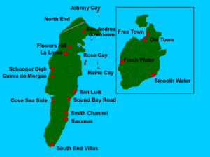 San Andrés is the largest of the island group in the Department of the Archipelago of San Andrés, Providencia and Santa Catalina. San Andrés is located in the Caribbean Sea, about 230 km (142.9 mi) from the coast of Nicaragua and north-eastern Costa Rica, and 750 km (466 mi) northwest of the coast of Colombia. The island is 12.5 km (7.8 mi) (11 km is also mentioned here) in length and 3 km (1.9 mi) in width. It has an area of 26 km² (10 sq mi) within the total area of the group of islands of 45 square kilometres (17.4 sq mi) (27 km² (10.4 sq mi) is also mentioned in this reference for San Andrés), making it the largest island in the archipelago. Providencia, the next largest in size, is located 80 km (49.7 mi) to the northeast. San Andrés has a fairly flat topography with the highest point in the island reported at an elevation of 55 m (180.4 ft) above sea level
.
San Andrés is crossed from south to north by a small mountain range whose highest peak is Cerro La Loma, also known as El Cliff. San Andrés' soils indicate that their formation is due to the eruption of a volcano which threw rocks older than the seafloor to the surface, creating the islands. Despite this, there is fertile soil and the soil is mostly red clay. It is easy to find small deposits of quartz
on the island, especially in the neighborhood of Loma Cove. Aside from the main settlements, the island is almost entirely covered in grass, trees and other vegetation, as well as sand along the coastline rather than rocks. The central area is marked by a chain of hills (Flowers, Orange, Shingle and Lion's Hill). The island has only small, ephemeral streams draining the land area, but no major rivers.
On the southwest coast of the island are some features, namely (from north to south) Bobby Rock, Boobie Rock, Fisher Rock and Tyler Rock. A feature named Rock Point is located on the southeastern coast. Suky Bay lies in the central western part of the island near Cove Sea Side. The northern part of the island has a beach, while the western part of the island has no beaches.
The island is surrounded on its northwest side by a small coral reef
(arrecifex) and several keys that are home to varied fauna and flora, and are visited by many tourists every year. The small cay in the San Andres Bay is said to be the most visited place in the archipelago. Johnny Cay is a small coral islet that is located 1.5 km (0.93205910497471 mi) to the north of San Andres Town. It is a scenic place with white-sand beaches surrounded by coconut plantations. The sea here is not suitable for swimming as the current of flow could be risky. A natural park was also created here in 2001. Haynes Cay is the place where cruise ships are docked. There are a number of large coral farms here with variety of species. The place is also popular for water sports activities like snorkeling and diving. Diving here with a mask and sandals (protection against sea urchins) colorful fish species can be seen. El Acuaro (Aquarium) Cay is off to the east coast of San Andres, adjoins the Haynes Cay. It is a popular center for snorkeling since the sea here has shallow and calm waters.
The avifaunal species of San Andrés Vireo
(Vireo caribacus), exclusive to the island, favors mangrove
and scrub bush habitat. It is a small, innocuous, but delicate bird, green in color, in the Aves class of Passeriforms of the Vireonidae family. It is about 5 inches (12.7 cm) in length, weighs about 16–20 g, found in clutch size of 2, and feeds on insects and fruits. IUCN has listed this bird species under the Critically endangered list. Its habitat has been threatened due to large-scale expansion of the island lands for development of the capital city in the last few decades. It is reported that habitat of these birds is now confined to about 18 km² (6.9 sq mi) area in the southern part of the island. Its distinguishing noise feature (song feature) is a single note repeated 2–20 times. In order to protect this local species, it has been suggested that the Mangrove swamps of the island be declared as a protected area. Another bird found in abundance on the island is the White-winged Dove
(Zenaida asiatica).
The aqua faunal species found here are oyster
s and crabs. The coral species found in the island’s shores are: Cuerno de Venado, Cuervo de Arce, Coral Columna, Brain coral
, Coral Látigo, star coral, fan coral, finger coral and Coral Pluma.
The only mammal
that has been recorded from San Andrés is the bat
Artibeus jamaicensis.
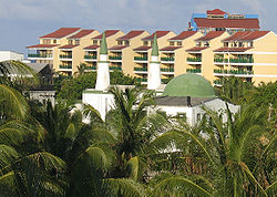
, known locally as El Centro, is the largest town, as well as the most developed commercial and tourist hub of the island. It is located at the northern end and is the capital of the department. The departmental administration, commerce, banks, several hotels and the airport are located in this area.
A smaller village, La Loma, is inhabited by the native islander population and is at the center of the island. Its traditional fame is due to the Baptist Church that was established in 1847. This church was rebuilt with pine wood imported from Alabama. The Baptist church was built along the central road to La Loma, which functioned as a beacon for shipping. Located at the top of the hill, La Loma provides lovely views of the “seven colored sea” (Caribbean Sea).
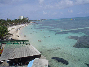
On the eastern coast of the island is San Luis, which is a small tourist town. It is notable both as a tourist establishment and for its impressive stretch of white-sand beach. Traditional wooden houses are also located on the shores of the beach, spread over a 3 km (1.9 mi) stretch. Here also, in view of generally calm sea water (only occasionally rough), snorkeling is a popular sporting activity. It used to be port for export of coconuts.
-speaking locals. This culture was called the Raizal
culture of the Afro-Caribbean ethnic group. It is now more a blend of Latin American and English-Caribbean culture that is witnessed in the island. Other minority groups living in the island are the Chinese and the Middle Eastern people.
 San Andres is also famous for its local version of music that includes calypso
, soca
, reggae
and church music
. Concerts are held yearly in May at the Old Coliseum during the "Green Festival". Other celebrations and events held in the island are the independence day celebrations on 20 July and the "Coconut Queen" (Reinado del Coco) festival held in November.
Religion
The islanders practice obeah
, a West Indies religious practice of voodoo witchcraft
derived from African traditional religion
. Other religions are also supported, for example, there is Iglesia Bautista Emmanuel, built in La Loma in 1847, and a mosque
. Baptists and Roman Catholics now coexist on the island.
Attractions
The San Andrés Island, which attracts a large number of visitors, has many places of interest. Some of the important ones are: The La Loma with its Baptist Church, a small geyser at Hoyo Soplador, the snorkeling site at La Piscinita, white beaches of San Luis, the coral islet of Johnny Cay, the Pond, Haynes Cay, Morgan's Cave, West View and Acuaro of the coast known for its diving center. The small cay in the San Andres Bay is said to be the most visited place in the Archipelago. El Cove ("the cove") provides the deepest anchorage facilities on the island. Diving is a popular water sport in the island. The depth of water which varies in the range 3 metre has a visibility of 10 metre are favorable conditions for diving. The underwater formations seen during the diving are of three types namely, walls of seaweed and minor coral reefs, large groups of different types of coral, and underwater plateaus with much marine life. Diving lessons are provided by several sports agencies.
 La Piscinita, located in the western part of the island has a calm sea which permits snorkeling activity. The site has abundant fish resources. Hoyo Soplador is situated at the southern end of the island. A geyser
emerging from the sea shoots up to a height of 20 metres (65.6 ft), emerging from a hole in the coral rock. This phenomenon is noticed only at certain times of the year when tide and wind direction favor such an action. It is also the center of an International Surf Competition held once a year. The Pond, also called La Laguna ("Big Pond"), situated on top of the hill, is 400 metres (1,312.3 ft) long and 250 metres (820.2 ft) wide. Its fresh water source is from rainfall and the lake is 30 metres (98.4 ft) deep. It has rich biodiversity of white Heron, pigeon, palm trees and fruit trees. A little alligator
species is also seen here. Morgan cave, named after the English pirate Henry Morgan, was the location where he hid his treasures. The cave is approached through an underwater passage. There is also a museum here. A Seaquarium here has good display of Caribbean marine life. West View, as the name suggests, has 3 metre depth of water and is a favorite place for snorkeling, swimming and diving.
Sport
Held on Saturdays, horseracing is a weekly event, even if only two horses race. Cockfighting, more popular on the island than football is in England, is considered to be a traditional sporting event rather than animal cruelty.
have flight services are offered by Avianca, Intercontinental, AeroRepublica and Caribbean Airways to Bogota, Cali, Cartagena, Costa Rica (San Jose) and Providencia; Copa offers flights from Panama City. There are also charter flights offered by Air Transat from Montréal-Pierre Elliott Trudeau International Airport
during winter months.
However, the sea route to visit the island is by cruise ships only (3–4 days journey). There are no passenger services to the island though some cargo ships do carry a few passengers. The island also has a good network of paved lateral roads connecting the main circular road which is of 30 kilometres (18.6 mi) length. A tourist train (improvised tractor with coaches) also operates within the island. Boat services are also available within the island to visit various small towns and other locations of tourist interest along the coast line.
Coral
Corals are marine animals in class Anthozoa of phylum Cnidaria typically living in compact colonies of many identical individual "polyps". The group includes the important reef builders that inhabit tropical oceans and secrete calcium carbonate to form a hard skeleton.A coral "head" is a colony of...
island among the Colombian islands in the Caribbean Sea
Caribbean Sea
The Caribbean Sea is a sea of the Atlantic Ocean located in the tropics of the Western hemisphere. It is bounded by Mexico and Central America to the west and southwest, to the north by the Greater Antilles, and to the east by the Lesser Antilles....
; it is the largest island of the southern group of islands. Together with the nearby island of Providencia
Providencia Island
Isla de Providencia or Old Providence is a mountainous Caribbean island. Though it is closer to Nicaragua, it is part of the Archipelago of San Andres, Providencia and Santa Catalina, a department of Colombia, lying midway between Costa Rica and Jamaica...
and some smaller islands of the southern group of the Colombian archipelago, San Andrés forms the department of San Andrés, Providencia and Santa Catalina. The island's location in South America
South America
South America is a continent situated in the Western Hemisphere, mostly in the Southern Hemisphere, with a relatively small portion in the Northern Hemisphere. The continent is also considered a subcontinent of the Americas. It is bordered on the west by the Pacific Ocean and on the north and east...
has been aptly described as "Geographically near Nicaragua
Nicaragua
Nicaragua is the largest country in the Central American American isthmus, bordered by Honduras to the north and Costa Rica to the south. The country is situated between 11 and 14 degrees north of the Equator in the Northern Hemisphere, which places it entirely within the tropics. The Pacific Ocean...
, past historically tied to England
England
England is a country that is part of the United Kingdom. It shares land borders with Scotland to the north and Wales to the west; the Irish Sea is to the north west, the Celtic Sea to the south west, with the North Sea to the east and the English Channel to the south separating it from continental...
, and politically part of Colombia
Colombia
Colombia, officially the Republic of Colombia , is a unitary constitutional republic comprising thirty-two departments. The country is located in northwestern South America, bordered to the east by Venezuela and Brazil; to the south by Ecuador and Peru; to the north by the Caribbean Sea; to the...
."
While San Andres island is located 50 km (31.1 mi) to the north of Providencia, the Colombian archipelago is approximately 750 km (466 mi) from the Colombian main land and about 230 km (142.9 mi) east of Nicaragua. This archipelago encompass a total area of 57 km² (22 sq mi), including the outer cays, reefs, atolls and sand banks with 45 km² (17.4 sq mi) being the area of the islands. In 2000, it was declared a UNESCO Biosphere Reserve, named “Seaflower Biosphere Reserve”, which not only includes the islands but also about 10% of the Caribbean Sea, amounting to a vast marine area of 300000 km² (115,830.6 sq mi). The purpose of this declaration is to ensure that the ecosystem which has a large biodiversity is well preserved and conserved.
Located on the northern end of the island, the department's capital, also named San Andrés but nicknamed El Centro, is the main urban center. Along the 30 km (18.6 mi) road that circles the island, there are many picturesque beaches, coral reefs, cays, geysers, and coves. Also of note are La Loma, the town of San Andres, the Baptist Church, Seaquarium, the large pond of La Laguna, and a fresh water lake amidst mangrove
Mangrove
Mangroves are various kinds of trees up to medium height and shrubs that grow in saline coastal sediment habitats in the tropics and subtropics – mainly between latitudes N and S...
forests. There are coconut palm plantations, lush pastures, and tall native trees reaching 20 metres (65.6 ft). Surrounded by the warm Caribbean Sea, all of these features have made the island an "exotic holiday destination".
History
16th centuryHistory of the San Andres and Providence is replete with adventures of pirates, their invasions and occupation of the islands. San Andrés was discovered sometime before 1527 by Spanish voyagers but it wasn't until this year that the islands began appearing on Spanish maps. The Dutch
Netherlands
The Netherlands is a constituent country of the Kingdom of the Netherlands, located mainly in North-West Europe and with several islands in the Caribbean. Mainland Netherlands borders the North Sea to the north and west, Belgium to the south, and Germany to the east, and shares maritime borders...
are reported to have come to these islands at the end of the 16th century and British settlers arrived there in 1628. It is also mentioned that Columbus
Christopher Columbus
Christopher Columbus was an explorer, colonizer, and navigator, born in the Republic of Genoa, in northwestern Italy. Under the auspices of the Catholic Monarchs of Spain, he completed four voyages across the Atlantic Ocean that led to general European awareness of the American continents in the...
discovered these islands during his fourth exploration voyage
Voyages of Christopher Columbus
In the early modern period, the voyages of Columbus initiated European exploration and colonization of the American continents, and are thus of great significance in world history. Christopher Columbus was a navigator and an admiral for Castile, a country that later founded modern Spain...
.
17th century
The English
English people
The English are a nation and ethnic group native to England, who speak English. The English identity is of early mediaeval origin, when they were known in Old English as the Anglecynn. England is now a country of the United Kingdom, and the majority of English people in England are British Citizens...
puritans (English
England
England is a country that is part of the United Kingdom. It shares land borders with Scotland to the north and Wales to the west; the Irish Sea is to the north west, the Celtic Sea to the south west, with the North Sea to the east and the English Channel to the south separating it from continental...
Protestants from Scotland
Scotland
Scotland is a country that is part of the United Kingdom. Occupying the northern third of the island of Great Britain, it shares a border with England to the south and is bounded by the North Sea to the east, the Atlantic Ocean to the north and west, and the North Channel and Irish Sea to the...
) were the first to arrive; they hailed from Barbados
Barbados
Barbados is an island country in the Lesser Antilles. It is in length and as much as in width, amounting to . It is situated in the western area of the North Atlantic and 100 kilometres east of the Windward Islands and the Caribbean Sea; therein, it is about east of the islands of Saint...
and also from England
England
England is a country that is part of the United Kingdom. It shares land borders with Scotland to the north and Wales to the west; the Irish Sea is to the north west, the Celtic Sea to the south west, with the North Sea to the east and the English Channel to the south separating it from continental...
to between 1627 and 1629 to settle in the salubrious climate and fertile lands of the islands. The British evicted the Dutch settlers in 1631. Settlers also came from Wales
Wales
Wales is a country that is part of the United Kingdom and the island of Great Britain, bordered by England to its east and the Atlantic Ocean and Irish Sea to its west. It has a population of three million, and a total area of 20,779 km²...
and Holland. All colonists first came to San Andrés and later moved to Providence Island
Providencia Island
Isla de Providencia or Old Providence is a mountainous Caribbean island. Though it is closer to Nicaragua, it is part of the Archipelago of San Andres, Providencia and Santa Catalina, a department of Colombia, lying midway between Costa Rica and Jamaica...
as its mountain terrain provided fresh water resources and safety from invaders. The black slave labor was inducted by the British in 1633 from Jamaica
Jamaica
Jamaica is an island nation of the Greater Antilles, in length, up to in width and 10,990 square kilometres in area. It is situated in the Caribbean Sea, about south of Cuba, and west of Hispaniola, the island harbouring the nation-states Haiti and the Dominican Republic...
to exploit the coloring wood trees, grow cotton and tobacco. In 1635, the Spaniards, realizing the economic importance of the island, attacked the archipelago. However the Spaniards were driven out soon after they occupied the islands. The pirates also operated from here, including English pirate Henry Morgan
Henry Morgan
Admiral Sir Henry Morgan was an Admiral of the Royal Navy, a privateer, and a pirate who made a name for himself during activities in the Caribbean, primarily raiding Spanish settlements...
who used it in 1670 as one of the centers of his operations. The pirates attacked Spanish
Spain
Spain , officially the Kingdom of Spain languages]] under the European Charter for Regional or Minority Languages. In each of these, Spain's official name is as follows:;;;;;;), is a country and member state of the European Union located in southwestern Europe on the Iberian Peninsula...
ships carrying gold and other precious material that sailed in the Caribbean waters. They also attacked Panama
Panama
Panama , officially the Republic of Panama , is the southernmost country of Central America. Situated on the isthmus connecting North and South America, it is bordered by Costa Rica to the northwest, Colombia to the southeast, the Caribbean Sea to the north and the Pacific Ocean to the south. The...
and Santa Maria
Santa Maria
Santa María or Santa Maria may refer to:*The name of the Blessed Virgin Mary or Mary, the mother of Jesus, in various languages such as Italian, Portuguese or SpanishIn nautical transport:...
. The bounty looted by the pirates is still believed to be hidden in some underwater cave in the area.
After the temporary Spanish occupation of the islands, they were in possession by the British from 1740 until 1787, when they agreed to respect the native islander population. In the year 1792, by Royal Warrant on 20 May, the Spanish informed the Captain General of Guatemala
Guatemala
Guatemala is a country in Central America bordered by Mexico to the north and west, the Pacific Ocean to the southwest, Belize to the northeast, the Caribbean to the east, and Honduras and El Salvador to the southeast...
, Don Bernardo Troncoso, to recognize the archipelago. The Catholic religion was spread on the island and a church was built and run by its own priest. San Andres gave exemption from import and export taxes.
19th century
On November 25, 1802, the inhabitants of the archipelago requested that they depend on the Viceroy
Viceroy
A viceroy is a royal official who runs a country, colony, or province in the name of and as representative of the monarch. The term derives from the Latin prefix vice-, meaning "in the place of" and the French word roi, meaning king. A viceroy's province or larger territory is called a viceroyalty...
alty of New Granada
Viceroyalty of New Granada
The Viceroyalty of New Granada was the name given on 27 May 1717, to a Spanish colonial jurisdiction in northern South America, corresponding mainly to modern Colombia, Ecuador, Panama, and Venezuela. The territory corresponding to Panama was incorporated later in 1739...
with the Mosquito Coast
Mosquito Coast
The Caribbean Mosquito Coast historically consisted of an area along the Atlantic coast of present-day Nicaragua and Honduras, and part of the Western Caribbean Zone. It was named after the local Miskito Indians and long dominated by British interests...
, and not on the Captaincy of Guatemala
Guatemala
Guatemala is a country in Central America bordered by Mexico to the north and west, the Pacific Ocean to the southwest, Belize to the northeast, the Caribbean to the east, and Honduras and El Salvador to the southeast...
. The document was signed by Mr. Roberto Clark, procurator, Isaac Brooks, Solomon Taylor, Jorge Olis, and Juan Taylor. As early as 1803, reports suggest that it was for political and economic reasons that San Andrés became a dependent Viceroyalty of New Granada. In 1810, independence from Spain arrived in New Granada. Councils were established in San Andrés and Providencia in this year. The government of Tomás Oneille granted land titles to white families of the two islands assuring people the ownership of the land. In July 1818, Luis Aury, and the independent forces of Simón Bolívar
Simón Bolívar
Simón José Antonio de la Santísima Trinidad Bolívar y Palacios Ponte y Yeiter, commonly known as Simón Bolívar was a Venezuelan military and political leader...
occupied the islands, and it became part of Gran Colombia
Gran Colombia
Gran Colombia is a name used today for the state that encompassed much of northern South America and part of southern Central America from 1819 to 1831. This short-lived republic included the territories of present-day Colombia, Venezuela, Ecuador, Panama, northern Peru and northwest Brazil. The...
on June 23, 1822.
In 1821, the issuing of the Constitution of Cúcuta
Constitution of Cúcuta
The Constitution of Cúcuta, also known as Constitution of the Gran Colombia and Constitution of 1821 was the founding document and constitution of the country of Gran Colombia, unifying the territories of the Viceroyalty of New Granada as part of a federation...
determined that every child born in Colombia, is born as a free citizen. On March 5, 1825 a League and Confederation Treaty with the United Provinces of Central America was signed and on June 15, 1826 the Treaty of Union, League and Confederation, between the Republics of Colombia, Central America
Central America
Central America is the central geographic region of the Americas. It is the southernmost, isthmian portion of the North American continent, which connects with South America on the southeast. When considered part of the unified continental model, it is considered a subcontinent...
, Peru
Peru
Peru , officially the Republic of Peru , is a country in western South America. It is bordered on the north by Ecuador and Colombia, on the east by Brazil, on the southeast by Bolivia, on the south by Chile, and on the west by the Pacific Ocean....
and Mexico
Mexico
The United Mexican States , commonly known as Mexico , is a federal constitutional republic in North America. It is bordered on the north by the United States; on the south and west by the Pacific Ocean; on the southeast by Guatemala, Belize, and the Caribbean Sea; and on the east by the Gulf of...
was signed in Panama in that "Contracting Parties shall ensure the integrity of its territories, then, under special conventions and to hold each other, have been demarcated and set their respective limits, the protection will then be placed under the protection of the confederation."
After independence was recognized by the coastal territories of the Caribbean Sea, the British proclaimed an independent territory in disregard of treaties and agreements of the time but the island remained free from British autonomy. In 1848, Tomás Cipriano de Mosquera
Tomás Cipriano de Mosquera
Tomás Cipriano de Mosquera y Arboleda was a Colombian general and political figure. He was president of Colombia four times. The first time was as president of Republic of New Granada from 1845 to 1849. During the Colombian Civil War of 1860-1862 he led liberal forces in a civil war against...
declared San Andrés as a Free port. In 1851, slavery was abolished by the constitution of Colombia, which led to a successful literacy movement led by pastor Philip Beekman Livinston.
20th century
In September 1900, France
France
The French Republic , The French Republic , The French Republic , (commonly known as France , is a unitary semi-presidential republic in Western Europe with several overseas territories and islands located on other continents and in the Indian, Pacific, and Atlantic oceans. Metropolitan France...
issued a ruling in which it recognized all of the islands of the archipelago as belonging to Colombia. In 1902, two commissioners of U.S. President
President of the United States
The President of the United States of America is the head of state and head of government of the United States. The president leads the executive branch of the federal government and is the commander-in-chief of the United States Armed Forces....
Theodore Roosevelt
Theodore Roosevelt
Theodore "Teddy" Roosevelt was the 26th President of the United States . He is noted for his exuberant personality, range of interests and achievements, and his leadership of the Progressive Movement, as well as his "cowboy" persona and robust masculinity...
came to San Andrés by boat and requested that the islanders becomes part of Panama, but American proposals were rejected outright as unpatriotic, proving local loyalty to the Republic of Colombia. In 1903, the Colombian Department of Panama became an independent nation. The islanders again refused to join the United States or Panama when they were visited by a U.S. warship in the same year. In 1912, by Law 52 of October 1926, the Municipality of San Andres and Providencia was established, giving administrative independence. In August 1920, a boundary treaty was signed between Colombia and Panama in Bogota
Bogotá
Bogotá, Distrito Capital , from 1991 to 2000 called Santa Fé de Bogotá, is the capital, and largest city, of Colombia. It is also designated by the national constitution as the capital of the department of Cundinamarca, even though the city of Bogotá now comprises an independent Capital district...
. On 24 March 1928, the Esguerra-Bárcenas Treaty
Esguerra-Bárcenas Treaty
The Esguerra-Bárcenas Treaty was signed between Colombia and Nicaragua on 24 March 1928. Under the terms of the treaty, Nicaragua recognized Colombia's sovereignty over the Archipelago of San Andrés, Providencia and Santa Catalina....
was signed, in which Nicaragua recognized Colombia's sovereignty over the Archipelago of San Andrés, Providencia and Santa Catalina.
In November 1943, Colombia joined World War II
World War II
World War II, or the Second World War , was a global conflict lasting from 1939 to 1945, involving most of the world's nations—including all of the great powers—eventually forming two opposing military alliances: the Allies and the Axis...
, because a German submarine sank one of their boats that had to transport British troops to San Andrés. In 1953, at the request of several representatives of the island community, President Gustavo Rojas Pinilla
Gustavo Rojas Pinilla
Gustavo Rojas Pinilla was a Colombian politician, military officer, General of the Army and President of Colombia between 1953 and 1957.- Biographic data :...
reaffirmed the San Andres Island and the free port. In 1972, the archipelago was declared as a Special Municipality. In the Colombian Constitution of 1991, the Department Archipelago of San Andrés, Providencia and Santa Catalina was established as one of the Departments of Colombia
Departments of Colombia
Colombia is an unitary republic formed by thirty-two departments and a Capital District . Each department has a Governor and a Department Assembly , elected by popular vote for a four-year period. The governor cannot be re-elected in consecutive periods...
. In 2000, the archipelago of San Andrés, Providencia and Santa Catalina became a UNESCO World Biosphere Reserve as per of the five biosphere reserves listed with the UNESCO’s Man and the Biosphere programme.
21st century
In 2001, Nicaragua declared that it disputed the 82 degrees longitude agreement which they signed under the Treaty of 1928 (and the 1930 Protocol of Exchange of Ratifications) and filed a formal complaint before the International Court of Justice
International Court of Justice
The International Court of Justice is the primary judicial organ of the United Nations. It is based in the Peace Palace in The Hague, Netherlands...
in The Hague
The Hague
The Hague is the capital city of the province of South Holland in the Netherlands. With a population of 500,000 inhabitants , it is the third largest city of the Netherlands, after Amsterdam and Rotterdam...
, claiming territory east of longitude 82, including the archipelago of San Andrés. On December 13, 2007, the International Court of Justice recognized the full sovereignty of Colombia over the islands of San Andrés, Providencia and Santa Catalina, but left open the question about the demarcation of the maritime boundary in the meridian 82 and the sovereignty of one of the two nations over the keys of Serranilla, Quitasueño, Serrana
Serrana Bank
The Serrana Bank is one of the few atolls in the Atlantic Ocean. Its mostly underwater reef of about 50 km long and 13 km wide has six cays or islets, the most prominent of which is Southwest Cay.The cays from south to north are:...
, Roncador and Bajo Nuevos. The ICJ also ruled it "upheld preliminary objections of Colombia to its jurisdiction only insofar as they concerned sovereignty over the islands of San Andrés, Providencia and Santa Catalina".
Geography
Above mean sea level
The term above mean sea level refers to the elevation or altitude of any object, relative to the average sea level datum. AMSL is used extensively in radio by engineers to determine the coverage area a station will be able to reach...
.
San Andrés is crossed from south to north by a small mountain range whose highest peak is Cerro La Loma, also known as El Cliff. San Andrés' soils indicate that their formation is due to the eruption of a volcano which threw rocks older than the seafloor to the surface, creating the islands. Despite this, there is fertile soil and the soil is mostly red clay. It is easy to find small deposits of quartz
Quartz
Quartz is the second-most-abundant mineral in the Earth's continental crust, after feldspar. It is made up of a continuous framework of SiO4 silicon–oxygen tetrahedra, with each oxygen being shared between two tetrahedra, giving an overall formula SiO2. There are many different varieties of quartz,...
on the island, especially in the neighborhood of Loma Cove. Aside from the main settlements, the island is almost entirely covered in grass, trees and other vegetation, as well as sand along the coastline rather than rocks. The central area is marked by a chain of hills (Flowers, Orange, Shingle and Lion's Hill). The island has only small, ephemeral streams draining the land area, but no major rivers.
On the southwest coast of the island are some features, namely (from north to south) Bobby Rock, Boobie Rock, Fisher Rock and Tyler Rock. A feature named Rock Point is located on the southeastern coast. Suky Bay lies in the central western part of the island near Cove Sea Side. The northern part of the island has a beach, while the western part of the island has no beaches.
The island is surrounded on its northwest side by a small coral reef
Coral reef
Coral reefs are underwater structures made from calcium carbonate secreted by corals. Coral reefs are colonies of tiny living animals found in marine waters that contain few nutrients. Most coral reefs are built from stony corals, which in turn consist of polyps that cluster in groups. The polyps...
(arrecifex) and several keys that are home to varied fauna and flora, and are visited by many tourists every year. The small cay in the San Andres Bay is said to be the most visited place in the archipelago. Johnny Cay is a small coral islet that is located 1.5 km (0.93205910497471 mi) to the north of San Andres Town. It is a scenic place with white-sand beaches surrounded by coconut plantations. The sea here is not suitable for swimming as the current of flow could be risky. A natural park was also created here in 2001. Haynes Cay is the place where cruise ships are docked. There are a number of large coral farms here with variety of species. The place is also popular for water sports activities like snorkeling and diving. Diving here with a mask and sandals (protection against sea urchins) colorful fish species can be seen. El Acuaro (Aquarium) Cay is off to the east coast of San Andres, adjoins the Haynes Cay. It is a popular center for snorkeling since the sea here has shallow and calm waters.
Climate
The island experiences a warm climate with average temperatures ranging from 26 °C (78.8 °F) to 29 °C (84.2 °F) in two periods dominated by dry and rainy spells. The rainy season is from September to December and also from May to June, when humidity is also high here. The trade winds from the north begin to blow in late October and during November and December until mid-January, the wind usually blows from the east, when there are storms in the northeastern Caribbean.Demographics
The island's last reported population is 75,000; it was, 55,000 in 1993, and 20,000 in 1973. The continuous growth and influx of people from the mainland of Colombia form about two thirds of the island's population. The native islanders are the descendants of the Jamaican slaves and they grudgingly tolerate the immigrants from the mainland.Economy
The economy of the island, which was largely dependent on fishery resources and meager agricultural produces, underwent a change with the opening of air services from Colombia, followed by a 1954 declaration of the island as a duty free zone. This brought about a large influx of tourists to the island apart from immigrants from the mainland. This also resulted in the local government imposing restrictions in the 1990s to control the influx of people from the mainland, with intent to preserve local culture. However, there are no industries in the island.Flora and fauna
The island has rich floral diversity in its vast mangrove swamps, the largest mangrove forest on the island being the Old Mangrove Point Regional Park. There are 12 mangrove forests in red, black and white colors, rich with many species of flora and fauna revitalizing the ecosystem. There are also coconut palm trees, tall growth of local trees, green and lush pastoral lands and farm lands.The avifaunal species of San Andrés Vireo
Vireo
The vireos are a group of small to medium-sized passerine birds restricted to the New World. They are typically dull-plumaged and greenish in color, the smaller species resembling wood warblers apart from their heavier bills...
(Vireo caribacus), exclusive to the island, favors mangrove
Mangrove
Mangroves are various kinds of trees up to medium height and shrubs that grow in saline coastal sediment habitats in the tropics and subtropics – mainly between latitudes N and S...
and scrub bush habitat. It is a small, innocuous, but delicate bird, green in color, in the Aves class of Passeriforms of the Vireonidae family. It is about 5 inches (12.7 cm) in length, weighs about 16–20 g, found in clutch size of 2, and feeds on insects and fruits. IUCN has listed this bird species under the Critically endangered list. Its habitat has been threatened due to large-scale expansion of the island lands for development of the capital city in the last few decades. It is reported that habitat of these birds is now confined to about 18 km² (6.9 sq mi) area in the southern part of the island. Its distinguishing noise feature (song feature) is a single note repeated 2–20 times. In order to protect this local species, it has been suggested that the Mangrove swamps of the island be declared as a protected area. Another bird found in abundance on the island is the White-winged Dove
White-winged Dove
The White-winged Dove is a dove whose native range extends from the south-western USA through Mexico, Central America, and the Caribbean. In recent years with increasing urbanization and backyard feeding, it has expanded throughout Texas and into Louisiana...
(Zenaida asiatica).
The aqua faunal species found here are oyster
Oyster
The word oyster is used as a common name for a number of distinct groups of bivalve molluscs which live in marine or brackish habitats. The valves are highly calcified....
s and crabs. The coral species found in the island’s shores are: Cuerno de Venado, Cuervo de Arce, Coral Columna, Brain coral
Brain coral
Brain coral is a common name given to corals in the family Faviidae so called due to their generally spheroid shape and grooved surface which resembles a brain...
, Coral Látigo, star coral, fan coral, finger coral and Coral Pluma.
The only mammal
Mammal
Mammals are members of a class of air-breathing vertebrate animals characterised by the possession of endothermy, hair, three middle ear bones, and mammary glands functional in mothers with young...
that has been recorded from San Andrés is the bat
Bat
Bats are mammals of the order Chiroptera "hand" and pteron "wing") whose forelimbs form webbed wings, making them the only mammals naturally capable of true and sustained flight. By contrast, other mammals said to fly, such as flying squirrels, gliding possums, and colugos, glide rather than fly,...
Artibeus jamaicensis.
Settlements
The population is grouped around a few residential areas. San AndrésSan Andrés
San Andrés is the Spanish name of Saint Andrew. San Andrés may refer to:*Argentina**San Andrés, city located in General San Martín Partido, northern zone of Greater Buenos Aires.**San Andrés de Giles, Buenos Aires Province*Bolivia...
, known locally as El Centro, is the largest town, as well as the most developed commercial and tourist hub of the island. It is located at the northern end and is the capital of the department. The departmental administration, commerce, banks, several hotels and the airport are located in this area.
A smaller village, La Loma, is inhabited by the native islander population and is at the center of the island. Its traditional fame is due to the Baptist Church that was established in 1847. This church was rebuilt with pine wood imported from Alabama. The Baptist church was built along the central road to La Loma, which functioned as a beacon for shipping. Located at the top of the hill, La Loma provides lovely views of the “seven colored sea” (Caribbean Sea).
On the eastern coast of the island is San Luis, which is a small tourist town. It is notable both as a tourist establishment and for its impressive stretch of white-sand beach. Traditional wooden houses are also located on the shores of the beach, spread over a 3 km (1.9 mi) stretch. Here also, in view of generally calm sea water (only occasionally rough), snorkeling is a popular sporting activity. It used to be port for export of coconuts.
Culture
Spanish is the main language. However, till the 1970s, the English language, architecture and religion were very much part of the island's culture with the CreoleCreole language
A creole language, or simply a creole, is a stable natural language developed from the mixing of parent languages; creoles differ from pidgins in that they have been nativized by children as their primary language, making them have features of natural languages that are normally missing from...
-speaking locals. This culture was called the Raizal
Raizal
The Raizals are a Protestant Afro-Caribbean ethnic group, speaking the San Andrés-Providencia Creole, an English Creole, living in the Archipelago of San Andrés, Providencia and Santa Catalina, presently the Colombian San Andrés y Providencia Department, off the Nicaraguan Miskito Coast...
culture of the Afro-Caribbean ethnic group. It is now more a blend of Latin American and English-Caribbean culture that is witnessed in the island. Other minority groups living in the island are the Chinese and the Middle Eastern people.
Calypso music
Calypso is a style of Afro-Caribbean music that originated in Trinidad and Tobago from African and European roots. The roots of the genre lay in the arrival of enslaved Africans, who, not being allowed to speak with each other, communicated through song...
, soca
Soca music
Soca is a style of music from Trinidad and Tobago. Soca is a musical development of traditional Trinidadian calypso, through loans from the 1960s onwards from predominantly black popular music....
, reggae
Reggae
Reggae is a music genre first developed in Jamaica in the late 1960s. While sometimes used in a broader sense to refer to most types of Jamaican music, the term reggae more properly denotes a particular music style that originated following on the development of ska and rocksteady.Reggae is based...
and church music
Church music
Church music may be defined as music written for performance in church, or any musical setting of ecclestiacal liturgy, or music set to words expressing propositions of a sacred nature, such as a hymn. This article covers music in the Judaeo-Christian tradition. For sacred music outside this...
. Concerts are held yearly in May at the Old Coliseum during the "Green Festival". Other celebrations and events held in the island are the independence day celebrations on 20 July and the "Coconut Queen" (Reinado del Coco) festival held in November.
Religion
The islanders practice obeah
Obeah
Obeah is a term used in the West Indies to refer to folk magic, sorcery, and religious practices derived from West African, and specifically Igbo origin. Obeah is similar to other African derived religions including Palo, Voodoo, Santería, rootwork, and most of all hoodoo...
, a West Indies religious practice of voodoo witchcraft
Witchcraft
Witchcraft, in historical, anthropological, religious, and mythological contexts, is the alleged use of supernatural or magical powers. A witch is a practitioner of witchcraft...
derived from African traditional religion
African Traditional Religion
The traditional religions indigenous to Africa have, for most of their existence, been orally rather than scripturally transmitted. They are generally associated with animism. Most have ethno-based creations stories...
. Other religions are also supported, for example, there is Iglesia Bautista Emmanuel, built in La Loma in 1847, and a mosque
Mosque
A mosque is a place of worship for followers of Islam. The word is likely to have entered the English language through French , from Portuguese , from Spanish , and from Berber , ultimately originating in — . The Arabic word masjid literally means a place of prostration...
. Baptists and Roman Catholics now coexist on the island.
Attractions
The San Andrés Island, which attracts a large number of visitors, has many places of interest. Some of the important ones are: The La Loma with its Baptist Church, a small geyser at Hoyo Soplador, the snorkeling site at La Piscinita, white beaches of San Luis, the coral islet of Johnny Cay, the Pond, Haynes Cay, Morgan's Cave, West View and Acuaro of the coast known for its diving center. The small cay in the San Andres Bay is said to be the most visited place in the Archipelago. El Cove ("the cove") provides the deepest anchorage facilities on the island. Diving is a popular water sport in the island. The depth of water which varies in the range 3 metre has a visibility of 10 metre are favorable conditions for diving. The underwater formations seen during the diving are of three types namely, walls of seaweed and minor coral reefs, large groups of different types of coral, and underwater plateaus with much marine life. Diving lessons are provided by several sports agencies.
Geyser
A geyser is a spring characterized by intermittent discharge of water ejected turbulently and accompanied by a vapour phase . The word geyser comes from Geysir, the name of an erupting spring at Haukadalur, Iceland; that name, in turn, comes from the Icelandic verb geysa, "to gush", the verb...
emerging from the sea shoots up to a height of 20 metres (65.6 ft), emerging from a hole in the coral rock. This phenomenon is noticed only at certain times of the year when tide and wind direction favor such an action. It is also the center of an International Surf Competition held once a year. The Pond, also called La Laguna ("Big Pond"), situated on top of the hill, is 400 metres (1,312.3 ft) long and 250 metres (820.2 ft) wide. Its fresh water source is from rainfall and the lake is 30 metres (98.4 ft) deep. It has rich biodiversity of white Heron, pigeon, palm trees and fruit trees. A little alligator
Alligator
An alligator is a crocodilian in the genus Alligator of the family Alligatoridae. There are two extant alligator species: the American alligator and the Chinese alligator ....
species is also seen here. Morgan cave, named after the English pirate Henry Morgan, was the location where he hid his treasures. The cave is approached through an underwater passage. There is also a museum here. A Seaquarium here has good display of Caribbean marine life. West View, as the name suggests, has 3 metre depth of water and is a favorite place for snorkeling, swimming and diving.
Sport
Held on Saturdays, horseracing is a weekly event, even if only two horses race. Cockfighting, more popular on the island than football is in England, is considered to be a traditional sporting event rather than animal cruelty.
Transportation
With the establishment of an airport in the island in the northern part, transport services from the mainland of Colombia ushered economic development in the island, particularly in the San Andres town. Gustavo Rojas Pinilla International AirportGustavo Rojas Pinilla International Airport
Gustavo Rojas Pinilla International Airport is the leading airport in the archipelago of San Andrés, Providencia and Santa Catalina, which has enough capacity to receive large aircraft, due to a number of charter flights and seasonal in different parts of America and Europe.- Description :The...
have flight services are offered by Avianca, Intercontinental, AeroRepublica and Caribbean Airways to Bogota, Cali, Cartagena, Costa Rica (San Jose) and Providencia; Copa offers flights from Panama City. There are also charter flights offered by Air Transat from Montréal-Pierre Elliott Trudeau International Airport
Montréal-Pierre Elliott Trudeau International Airport
Montréal-Pierre Elliott Trudeau International Airport or Montréal-Trudeau, formerly known as Montréal-Dorval International Airport, is located on the Island of Montreal, from Montreal's downtown core. The airport terminals are located entirely in Dorval, while the Air Canada headquarters complex...
during winter months.
However, the sea route to visit the island is by cruise ships only (3–4 days journey). There are no passenger services to the island though some cargo ships do carry a few passengers. The island also has a good network of paved lateral roads connecting the main circular road which is of 30 kilometres (18.6 mi) length. A tourist train (improvised tractor with coaches) also operates within the island. Boat services are also available within the island to visit various small towns and other locations of tourist interest along the coast line.