

Roads and freeways in metropolitan Detroit
Encyclopedia
Metro Detroit
The Detroit metropolitan area, often referred to as Metro Detroit, is the metropolitan area located in Southeast Michigan centered on the city of Detroit which shares an international border with Windsor, Ontario. The Detroit metropolitan area is the second largest U.S. metropolitan area...
region's extensive toll-free expressway system, together with its status as a major port city, provide advantages to its location as a global business center. There are no toll roads in Michigan
Michigan
Michigan is a U.S. state located in the Great Lakes Region of the United States of America. The name Michigan is the French form of the Ojibwa word mishigamaa, meaning "large water" or "large lake"....
.
Traditionally, Detroiters referred to their freeways by name rather than route number. That is still true today, with many Detroiters calling the freeways by their names, but numbers are in use as well. Other freeways are referred to only by number as in the case of I-275
Interstate 275 (Michigan)
Interstate 275 in the US state of Michigan is an Interstate Highway that functions as a western bypass of the Detroit metropolitan area. The Michigan Department of Transportation maintains it as a component of the larger state trunkline highway system. The freeway runs through the western suburbs...
and M-59
M-59 (Michigan highway)
M-59 is an east–west state trunkline highway that crosses the northern part of Metropolitan Detroit in the US state of Michigan. It runs between Howell at Interstate 96 and I-94 on the Chesterfield Township – Harrison Township line near the Selfridge Air National Guard Base...
: their names, if any, were never in common everyday usage. M-53, while not officially designated, is commonly called the Van Dyke Expressway. Detroit area freeways are typically sunken below ground level to permit local traffic to pass over the freeway.
History of Detroit, Michigan
The city of Detroit, Michigan, developed from a French fort and missionary outpost founded in 1701 to one of the largest American cities by the early 20th century. As reflected by the emblems on its flag, Detroit has been governed by three world powers: France, Great Britain, and the United States....
, Justice Augustus B. Woodward
Augustus B. Woodward
Augustus Brevoort Woodward was the first Chief Justice of the Michigan Territory. In that position, he played a prominent role in the planning and reconstruction of Detroit following a devastating fire.Woodward never married. His biographer, Arthur M...
devised a plan similar to Pierre Charles L'Enfant
Pierre Charles L'Enfant
Pierre Charles L'Enfant was a French-born American architect and civil engineer best known for designing the layout of the streets of Washington, D.C..-Early life:...
's design for Washington, D.C.
Washington, D.C.
Washington, D.C., formally the District of Columbia and commonly referred to as Washington, "the District", or simply D.C., is the capital of the United States. On July 16, 1790, the United States Congress approved the creation of a permanent national capital as permitted by the U.S. Constitution....
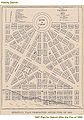
Detroit's monumental avenues and traffic circles fan out in a baroque
Baroque
The Baroque is a period and the style that used exaggerated motion and clear, easily interpreted detail to produce drama, tension, exuberance, and grandeur in sculpture, painting, literature, dance, and music...
styled radial fashion from Grand Circus Park in the heart of the city's theater district
Theatre in Detroit
Theatre in Detroit discusses performing arts in the city, its history, and its venues. With more than a dozen performing arts venues, the city's theatre district ranks as the second largest in the United States after Manhattan's Broadway, the stages and old time film palaces are generally located...
, which facilitates traffic patterns along the city's tree-lined boulevards and parks. The 'Woodward
Augustus B. Woodward
Augustus Brevoort Woodward was the first Chief Justice of the Michigan Territory. In that position, he played a prominent role in the planning and reconstruction of Detroit following a devastating fire.Woodward never married. His biographer, Arthur M...
plan' proposed a system of hexagonal street blocks, with the Grand Circus
Grand Circus Park (Detroit)
Grand Circus Park Historic District contains the Grand Circus Park in downtown Detroit, Michigan that connects the theatre district with its financial center. It is bisected by Woodward Avenue, four blocks north of Campus Martius Park, and is roughly bounded by Clifford, John R. and Adams...
at its center. Wide avenues, alternatively 200 feet (61 m) and 120 feet (36.6 m), would emanate from large circular plazas like spokes from the hub of a wheel. As the city grew these would spread in all directions from the banks of the Detroit River
Detroit River
The Detroit River is a strait in the Great Lakes system. The name comes from the French Rivière du Détroit, which translates literally as "River of the Strait". The Detroit River has served an important role in the history of Detroit and is one of the busiest waterways in the world. The river...
. When Woodward presented his proposal, Detroit had fewer than 1,000 residents. Elements of the plan were implemented. Most prominent of these are the five main "spokes" of Woodward, Michigan
Michigan Avenue
Michigan Avenue may refer to:* Michigan Avenue * Michigan Avenue , a designation for much of both current and former U.S. Route 12 in Michigan...
, Gratiot, Grand River
Grand River Avenue
US Highway 16 , also called Grand River Avenue for much of its length, is one of the principal pre-Interstate roads in the state of Michigan. Before the creation of the United States Numbered Highway System in 1926, the highway had been designated M-16...
and Jefferson
Jefferson Avenue (Detroit)
Jefferson Avenue is a scenic road along the eastern part of the Detroit metropolitan area in the U.S. state of Michigan. It travels alongside Lake Erie, the Detroit River, and Lake Saint Clair. This road also provides access to many recreational facilities in the area...
Avenues.
The Mile Road System in Metro Detroit
Metro Detroit
The Detroit metropolitan area, often referred to as Metro Detroit, is the metropolitan area located in Southeast Michigan centered on the city of Detroit which shares an international border with Windsor, Ontario. The Detroit metropolitan area is the second largest U.S. metropolitan area...
and Southeast Michigan
Southeast Michigan
Southeast Michigan, also called Southeastern Michigan, is a region in the Lower Peninsula of the U.S. state of Michigan that is home to a majority of the state's businesses and industries as well as slightly over half of the state's population, most of whom are concentrated in Metro...
facilitates ease of navigation in the region. It was established as a way to delineate east–west roads through the Detroit area and the surrounding rural rim. The Mile Road system, and its most famous road, 8 Mile Road, came about largely as a result of the Land Ordinance of 1785
Land Ordinance of 1785
The Land Ordinance of 1785 was adopted by the United States Congress on May 20, 1785. Under the Articles of Confederation, Congress did not have the power to raise revenue by direct taxation of the inhabitants of the United States...
, which established the basis for the Public Land Survey System
Public Land Survey System
The Public Land Survey System is a method used in the United States to survey and identify land parcels, particularly for titles and deeds of rural, wild or undeveloped land. Its basic units of area are the township and section. It is sometimes referred to as the rectangular survey system,...
in which land throughout the Northwest Territory
Northwest Territory
The Territory Northwest of the River Ohio, more commonly known as the Northwest Territory, was an organized incorporated territory of the United States that existed from July 13, 1787, until March 1, 1803, when the southeastern portion of the territory was admitted to the Union as the state of Ohio...
was surveyed and divided into survey township
Survey township
Survey township, sometimes called Congressional township, as used by the United States Public Land Survey System, refers to a square unit of land, that is nominally six miles on a side...
s by reference to a baseline
Baseline (surveying)
In the United States Public Land Survey System, a baseline is the principal east-west line that divides survey townships between north and south. The baseline meets its corresponding meridian at the point of origin, or initial point, for the land survey...
(east–west line) and meridian
Principal meridian
A meridian is an imaginary line on the Earth's surface from the North Pole to the South Pole that connects all locations with a given longitude. Each is half of a great circle on the Earth's surface...
(north–south line). In Southeast Michigan, many roads would be developed parallel to the base line and the meridian, and many of the east–west roads would be incorporated into the Mile Road System.
The Mile Road System extended easterly into Detroit, but is interrupted, because much of Detroit's early settlements and farms were based on early French land grants that were aligned northwest-to-southeast with frontage along the Detroit River
Detroit River
The Detroit River is a strait in the Great Lakes system. The name comes from the French Rivière du Détroit, which translates literally as "River of the Strait". The Detroit River has served an important role in the history of Detroit and is one of the busiest waterways in the world. The river...
and on later development along roads running into downtown Detroit in a star pattern, such as Woodward
M-1 (Michigan highway)
M-1, commonly known as Woodward Avenue, named for Augustus B. Woodward, is a north–south state trunkline in the US state of Michigan. Until a few years ago, the northern terminus of M-1 was at BL I-75 and BUS US 24 in Bloomfield Township between the city limits of Bloomfield Hills and...
, Jefferson
Jefferson Avenue (Detroit)
Jefferson Avenue is a scenic road along the eastern part of the Detroit metropolitan area in the U.S. state of Michigan. It travels alongside Lake Erie, the Detroit River, and Lake Saint Clair. This road also provides access to many recreational facilities in the area...
, Grand River
Grand River Avenue
US Highway 16 , also called Grand River Avenue for much of its length, is one of the principal pre-Interstate roads in the state of Michigan. Before the creation of the United States Numbered Highway System in 1926, the highway had been designated M-16...
, Gratiot
M-3 (Michigan highway)
M-3 is a north–south state highway in the US state of Michigan in the Detroit metropolitan area. For most of its length, M-3 is known as Gratiot Avenue...
, and Michigan Avenues, developed by Augustus Woodward in imitation of Washington, D.C.
Washington, D.C.
Washington, D.C., formally the District of Columbia and commonly referred to as Washington, "the District", or simply D.C., is the capital of the United States. On July 16, 1790, the United States Congress approved the creation of a permanent national capital as permitted by the U.S. Constitution....
's system. As Detroit grew, several Mile Roads were given new names within the city borders, while some roads incorporated as part of the Mile Road System have traditionally been known by their non-mile names. It is unclear if they ever bore mile numbers formally.
The baseline used in the survey of Michigan lands runs along 8 Mile Road, which is approximately eight miles directly north of the junction of Woodward Avenue and Michigan Avenue in downtown Detroit. As a result, the direct east–west portion of Michigan Avenue, and M-153
M-153 (Michigan highway)
M-153 is a state trunkline highway in the U.S. state of Michigan. It is also known as Ford Road for nearly its entire length, except for its westernmost portion where it splits from Ford Road and junctions with the M-14 freeway...
(Ford Road) west of Wyoming Avenue, forms the "zero mile" baseline for this mile road system.
The precise point of origin is located in Campus Martius Park
Campus Martius Park
Campus Martius Park is a re-established park in downtown Detroit, Michigan. After the fire of 1805, Campus Martius was the focal point of judge Augustus Woodward's plans to rebuild the city. It is where the "point of origin" of Detroit's coordinate system is located...
, marked by a medallion embedded in the stone walkway. It is situated in the western point of the diamond surrounding Woodward Fountain, just in front of the Fountain Bistro.
Freeways

.png)
 |
I-75 Interstate 75 in Michigan Interstate 75 is a part of the Interstate Highway System and runs from Miami, Florida to Sault Ste. Marie in the Upper Peninsula of Michigan. I-75 enters the state from Ohio in the south, just to the north of Toledo. It runs generally north through Detroit, Pontiac and Bay City, crossing the... (known as the Walter P. Chrysler Walter Chrysler Walter Percy Chrysler was an American machinist, railroad mechanic and manager, automotive industry executive, Freemason, and founder of the Chrysler Corporation.- Railroad career :... Freeway from Downtown Detroit to Pontiac in the north and Fisher Fisher Body Fisher Body is an automobile coachbuilder founded by the Fisher brothers in 1908 in Detroit, Michigan; it is now an operating division of General Motors Company... Freeway though southern and central Detroit) is the region's main north-south route, serving Flint, Pontiac, Troy, and Detroit, before continuing south (as the Detroit-Toledo and Seaway Freeways) to serve many of the communities along the shore of Lake Erie Lake Erie Lake Erie is the fourth largest lake of the five Great Lakes in North America, and the tenth largest globally. It is the southernmost, shallowest, and smallest by volume of the Great Lakes and therefore also has the shortest average water residence time. It is bounded on the north by the... ,most notably Toledo, Ohio Toledo, Ohio Toledo is the fourth most populous city in the U.S. state of Ohio and is the county seat of Lucas County. Toledo is in northwest Ohio, on the western end of Lake Erie, and borders the State of Michigan... . |
 |
I-94 Interstate 94 in Michigan Interstate 94 is a part of the Interstate Highway System that runs from Billings, Montana, to the Lower Peninsula of the US state of Michigan. In Michigan, it is a state trunkline highway that enters the state south of New Buffalo... (Edsel Ford Edsel Ford Edsel Bryant Ford , son of Henry Ford, was born in Detroit, Michigan, USA. He was president of Ford Motor Company from 1919 until his death in 1943.-Life and career:... Freeway & Detroit Industrial Expressway) runs east-west through Detroit and serves Ann Arbor to the west (where it continues to Chicago Chicago Chicago is the largest city in the US state of Illinois. With nearly 2.7 million residents, it is the most populous city in the Midwestern United States and the third most populous in the US, after New York City and Los Angeles... ) and Port Huron to the northeast. The stretch of the current I-94 freeway from Ypsilanti to Detroit was one of America's earlier limited-access highways. Henry Ford built it to link his factories at Willow Run Willow Run The Willow Run manufacturing plant, located between Ypsilanti and Belleville, Michigan, was constructed during World War II by Ford Motor Company for the mass production of the B-24 Liberator military aircraft.... and Dearborn Dearborn, Michigan -Economy:Ford Motor Company has its world headquarters in Dearborn. In addition its Dearborn campus contains many research, testing, finance and some production facilities. Ford Land controls the numerous properties owned by Ford including sales and leasing to unrelated businesses such as the... during World War II World War II World War II, or the Second World War , was a global conflict lasting from 1939 to 1945, involving most of the world's nations—including all of the great powers—eventually forming two opposing military alliances: the Allies and the Axis... . It also serves the North Access to the Detroit Metro Airport Detroit Metropolitan Wayne County Airport Detroit Metropolitan Wayne County Airport , usually called Detroit Metro Airport, Metro Airport locally, or simply DTW, is a major international airport covering in Romulus, Michigan, a suburb of Detroit. It is Michigan's busiest airport.... in Romulus Romulus, Michigan Romulus is a suburban city of Metro Detroit, located in Wayne County in the U.S. state of Michigan. The population was 23,989 at the 2010 census, an increase from 22,979 in 2000. Romulus is home to Detroit Metropolitan Wayne County Airport and a General Motors plant that opened in 1976... . A portion was known as the Willow Run Expressway. |
 |
I-96 runs northwest-southeast through Livingston, Oakland and Wayne counties and has its eastern terminus in downtown Detroit. Originally named the Edward Jeffries Edward Jeffries Edward J. Jeffries Jr. was an American politician, councilman, and mayor of Detroit.-Early life:Edward Jeffries was born in Detroit, Michigan On April 3, 1900, the son Judge Edward J. Jeffries and Minnie Stott Jeffries. The elder Jeffries was an alderman, a police justice, and a long-serving... Freeway in Wayne County, the portion between the Fisher and the Ford was renamed by the state legislature to the Rosa Parks Rosa Parks Rosa Louise McCauley Parks was an African-American civil rights activist, whom the U.S. Congress called "the first lady of civil rights", and "the mother of the freedom movement".... Memorial Highway in December 2005. |
 |
I-275 runs north-south from I-75 in the south to the junction of I-96 and I-696 in the north, providing a bypass through the western suburbs of Detroit. |
 |
I-375 is a short spur route in downtown Detroit, an extension of the Chrysler Freeway. |
 |
I-696 (Walter P. Reuther Walter Reuther Walter Philip Reuther was an American labor union leader, who made the United Automobile Workers a major force not only in the auto industry but also in the Democratic Party in the mid 20th century... Freeway) runs east-west from the junction of I-96 and I-275, providing a route through the northern suburbs of Detroit. Taken together, I-275 and I-696 form a semicircle around Detroit. |
 |
M-5 M-5 (Michigan highway) M-5 is a highway in the metro Detroit area of the US state of Michigan.-Route description:M-5's eastern terminus is at the junction of Grand River Avenue and Interstate 96 in western Detroit... This freeway begins as the stub leftover from the Brighton-Farmington Expressway after Interstate 96 Interstate 96 Interstate 96 is an intrastate Interstate Highway that is entirely within the US state of Michigan. Its western terminus is at an interchange with US Highway 31 and Business US Highway 31 , on the western boundary of Norton Shores southeast of Muskegon. Its eastern terminus is at I-75 near the... was rerouted to the Jeffries. From 1994 to 2002, it was extended north as the Haggerty Connector. |
 |
M-8 M-8 (Michigan highway) M-8 is a state trunkline highway in the U.S. state of Michigan lying within the cities of Detroit and Highland Park. Much of it is the Davison Freeway, the nation's first urban depressed freeway, which became a connector between the Lodge and the Chrysler Freeways.Named for an English immigrant... is the Davison Freeway. Opened in 1942, this was the first modern depressed limited-access freeway in America. |
 |
M-10 M-10 (Michigan highway) M-10, is a state trunkline route in the US state of Michigan. The southernmost portion follows Jefferson Avenue in downtown Detroit, and the southern terminus is at the intersection of Jefferson and Randolph Street leading to the entrance to the Detroit–Windsor Tunnel... : The John C. Lodge Freeway runs largely parallel to I-75 from Southfield to downtown. |
 |
M-14 M-14 (Michigan highway) M-14 is a east–west state trunkline highway in the southeastern portion of the US state of Michigan. Entirely freeway, it connects Ann Arbor with Detroit by way of connecting with I-96.-Route description:... runs east-west from I-275 in Livonia to Ann Arbor. |
 |
M-39 M-39 (Michigan highway) M-39 is a state highway in the US state of Michigan that runs from Lincoln Park to Southfield. The southern terminus of M-39 is at the corner of Southfield Road and Lafayette Boulevard in Lincoln Park, one block southeast of the junction of I-75 and two blocks northwest of M-85... : The Southfield Freeway runs north-south from Southfield to Allen Park from I-94. North of 10 Mile Road, the freeway ends and continues as Southfield Road into Birmingham. |
 |
M-53 M-53 (Michigan highway) M-53 is a gateway route to The Thumb region of the US state of Michigan, carrying vacationers to the many cottages and resorts located on Saginaw Bay and Lake Huron in the vicinity of Caseville and Port Austin. This highway is also used to transport agricultural and manufactured products from the... (Christopher Columbus Freeway from Sterling Heights Sterling Heights, Michigan Sterling Heights is a city in Macomb County of the U.S. state of Michigan, and one of Detroit's core suburbs. As of the 2010 census, the city had a total population of 129,699... to Washington), more commonly known as the Van Dyke Expressway or Van Dyke Freeway. Continues as Van Dyke Road or Van Dyke Avenue north to Port Austin and south through Warren Warren, Michigan Warren is a city in Macomb County in the U.S. state of Michigan. The 2010 census places the city's population at 134,056, making Warren the largest city in Macomb County, the third largest city in Michigan, and Metro Detroit's largest suburb.... to Gratiot Avenue in Detroit. |
 |
M-59 M-59 (Michigan highway) M-59 is an east–west state trunkline highway that crosses the northern part of Metropolitan Detroit in the US state of Michigan. It runs between Howell at Interstate 96 and I-94 on the Chesterfield Township – Harrison Township line near the Selfridge Air National Guard Base... (Veterans Memorial Freeway from Utica Utica, Michigan Utica is a city in Macomb County in the U.S. state of Michigan. The population was 4,577 at the 2000 census. The 2008 Census Bureau Estimate places the population at 4,924.- History :... to Pontiac), continues east as Hall Road to Clinton Township Clinton Charter Township, Michigan The Charter Township of Clinton, usually referred to as Clinton Township, is a charter township of Macomb County in the U.S. state of Michigan. It is a part of Metro Detroit. As of the 2010 census, the township had a total population of 96,796, and is Michigan's most populous township... and west as Huron Road through Pontiac and Waterford, and as Highland Road further west through Highland and Milford to I-96 near Howell Howell, Michigan Howell is a city in the U.S. state of Michigan. As of the 2010 census, the city had a total population of 9,489. It is the county seat of Livingston County and is located mostly within Howell Township, but is politically independent from Howell Township... |
Other selected major roads
- 8 Mile RoadM-102 (Michigan highway)M-102 is a state trunkline in the US state of Michigan, running along the northern boundary of Detroit. It is known as 8 Mile Road for most of its length. As part of the land surveying of the state, the road follows the Michigan Baseline, and it is called Base Line Road in places. M-102 is the...
, known by many due to the film 8 Mile8 Mile (film)8 Mile is a 2002 American hip-hop drama film written by Scott Silver, directed by Curtis Hanson, and starring Eminem, Mekhi Phifer, Brittany Murphy, and Kim Basinger....
, forms the dividing line between Detroit on the south and the suburbs of Macomb and Oakland counties on the north. It is also known as Baseline Road outside of Detroit, because it coincides with the baselineBaseline (surveying)In the United States Public Land Survey System, a baseline is the principal east-west line that divides survey townships between north and south. The baseline meets its corresponding meridian at the point of origin, or initial point, for the land survey...
used in surveying Michigan; that baseline is also the boundary for a number of Michigan counties. It is designated as M-102M-102 (Michigan highway)M-102 is a state trunkline in the US state of Michigan, running along the northern boundary of Detroit. It is known as 8 Mile Road for most of its length. As part of the land surveying of the state, the road follows the Michigan Baseline, and it is called Base Line Road in places. M-102 is the...
for much of its length in Wayne County. - Gratiot Avenue (M-3)M-3 (Michigan highway)M-3 is a north–south state highway in the US state of Michigan in the Detroit metropolitan area. For most of its length, M-3 is known as Gratiot Avenue...
is a major road that runs from Marysville to downtown Detroit. - Jefferson AvenueJefferson Avenue (Detroit)Jefferson Avenue is a scenic road along the eastern part of the Detroit metropolitan area in the U.S. state of Michigan. It travels alongside Lake Erie, the Detroit River, and Lake Saint Clair. This road also provides access to many recreational facilities in the area...
is a scenic highway that runs parallel to the shore of the Detroit RiverDetroit RiverThe Detroit River is a strait in the Great Lakes system. The name comes from the French Rivière du Détroit, which translates literally as "River of the Strait". The Detroit River has served an important role in the history of Detroit and is one of the busiest waterways in the world. The river...
and Lake St. ClairLake Saint Clair (North America)Lake St. Clair is a fresh-water lake named after Clare of Assisi that lies between the Province of Ontario and the State of Michigan, and its midline also forms the boundary between Canada and the United States of America. Lake St. Clair includes the Anchor Bay along the Metro Detroit coastline...
. It is also the principal thoroughfare for the Grosse PointeGrosse PointeGrosse Pointe refers to a coastal area in Metro Detroit, Michigan, United States that comprises five adjacent individual communities. From southwest to northeast, they are:*Grosse Pointe Park, city*Grosse Pointe, city*Grosse Pointe Farms, city...
s, where it is called Lake Shore Drive. Another important dividing line between Detroit and the city of Grosse Pointe ParkGrosse Pointe Park, MichiganGrosse Pointe Park is a city in Wayne County in the U.S. state of Michigan. The population was 11,555 at the 2010 census. Bordering on Detroit with frontage on southern Lake Saint Clair, it is the westernmost of the noted Grosse Pointe suburbs, with the oldest overall housing stock of the five cities...
is Alter RoadAlter RoadAlter Road is a north-south thoroughfare of approximately four miles length in southeastern Michigan's Wayne County.-Basic History:Although Alter Road itself is completely within the Detroit city limits, nevertheless it is a symbolic dividing line between the overwhelmingly African-American City of...
, where portions of some intersecting streets have been reconfigured or walled-off in order to thwart vehicular and pedestrian movement from Detroit into Grosse Pointe Park. - Michigan Avenue/US 12U.S. Route 12U.S. Route 12 or US 12 is an east–west United States highway, running from Grays Harbor on the Pacific Ocean, in the state of Washington, to downtown Detroit, for almost . As a thoroughfare, it has mostly been supplanted by I-90 and I-94, but remains an important road for local travel.The...
runs from downtown Detroit through the western suburbs toward Ypsilanti, passes south of Ann Arbor, and eventually reaches ChicagoChicagoChicago is the largest city in the US state of Illinois. With nearly 2.7 million residents, it is the most populous city in the Midwestern United States and the third most populous in the US, after New York City and Los Angeles...
. - Woodward Avenue (M-1)M-1 (Michigan highway)M-1, commonly known as Woodward Avenue, named for Augustus B. Woodward, is a north–south state trunkline in the US state of Michigan. Until a few years ago, the northern terminus of M-1 was at BL I-75 and BUS US 24 in Bloomfield Township between the city limits of Bloomfield Hills and...
is considered the Detroit area's main thoroughfare. It is the dividing line between the East Side and the West Side. Woodward stretches from downtown Pontiac to the Detroit RiverDetroit RiverThe Detroit River is a strait in the Great Lakes system. The name comes from the French Rivière du Détroit, which translates literally as "River of the Strait". The Detroit River has served an important role in the history of Detroit and is one of the busiest waterways in the world. The river...
near Hart Plaza. In Downtown Detroit, the Fox TheatreFox Theatre (Detroit)The Fox Theatre is an ornate performing arts center located at 2211 Woodward Avenue in downtown Detroit, Michigan, near Grand Circus Park. It was originally completed in 1928 as the first movie palace in the world to have sound systems for films. It was listed on the National Register of Historic...
and Detroit Institute of Arts are located on Woodward as well as the Detroit Zoo just outside of the city. The Woodward Dream CruiseWoodward Dream CruiseThe Woodward Dream Cruise event is a classic car event held annually on the third Saturday of August in Metropolitan Detroit, along Woodward Avenue. The WDC Event spans much of the avenue, from Pontiac through Ferndale in Oakland County, Michigan, all the way to the State Fair Grounds inside the...
, a classic car cruise from Pontiac to FerndaleFerndale, MichiganFerndale is adjacent to the cities of Detroit to the south, Oak Park to the west, Hazel Park to the east, Pleasant Ridge to the north, Royal Oak Township to the southwest, and Royal Oak to the north....
is held in August and is the largest single day classic car cruise in America. - Telegraph Road (US 24U.S. Route 24U.S. Route 24 is one of the original United States highways of 1926. It originally ran from Pontiac, Michigan, in the east to Kansas City, Missouri, in the west. Today, the highway's eastern terminus is west of Clarkston, Michigan, at an intersection with I-75 and its western terminus is near...
) is a major north-south road extending from Toledo, OhioToledo, OhioToledo is the fourth most populous city in the U.S. state of Ohio and is the county seat of Lucas County. Toledo is in northwest Ohio, on the western end of Lake Erie, and borders the State of Michigan...
through Monroe, Wayne, and Oakland Counties to PontiacPontiac, MichiganPontiac is a city in the U.S. state of Michigan named after the Ottawa Chief Pontiac, located within the Detroit metropolitan area. As of the 2010 census, the city had a total population of 59,515. It is the county seat of Oakland County...
. It has gained notoriety in a song (Telegraph Road) by the group Dire StraitsDire StraitsDire Straits were a British rock band active from 1977 to 1995, composed of Mark Knopfler , his younger brother David Knopfler , John Illsley , and Pick Withers .Dire Straits' sound drew from a variety of musical influences, including jazz, folk, blues, and came closest...
. - Dixie HighwayDixie HighwayThe Dixie Highway was a United States automobile highway, first planned in 1914 to connect the US Midwest with the Southern United States. It was part of the National Auto Trail system, and grew out of an earlier Miami to Montreal highway. The final result is better understood as a small network of...
or (Dix-Toledo) is one of America's historic highways. Its eastern division extended from Miami, FL to Sault Ste. Marie, MI. The remnants of this highway exist northbound and southbound through the Detroit metropolitan area. - Fort Street (M-85)M-85 (Michigan highway)M-85, also known as Fort Street or Fort Road for its entire length, is a state highway route in the U.S. state of Michigan.In Detroit proper, M-85 consists of West Fort street and South Fort street...
is the only Michigan highway in Downriver. It extends from Flat Rock to Detroit. - Grand River AvenueGrand River AvenueUS Highway 16 , also called Grand River Avenue for much of its length, is one of the principal pre-Interstate roads in the state of Michigan. Before the creation of the United States Numbered Highway System in 1926, the highway had been designated M-16...
connects the suburbs of Brighton, Novi, and Farmington to downtown Detroit. It is one of the five roads planned by Judge Augustus Woodward to radiate out from Detroit and connect the city to other parts of the state. It extends out to Lansing and in East Lansing is the main road and the dividing line between the city of East Lansing and the campus of Michigan State University.
Mile roads within Wayne County
The mile roads that cross through Wayne CountyWayne County, Michigan
-History:Wayne County was one of the first counties formed when the Northwest Territory was organized. It was named for the American general "Mad Anthony" Wayne. It originally encompassed the entire area of the Lower Peninsula of Michigan, as well as small sections that are now part of northern...
are designated as follows:
- 0 Mile - Michigan Avenue in Detroit; Ford RoadM-153 (Michigan highway)M-153 is a state trunkline highway in the U.S. state of Michigan. It is also known as Ford Road for nearly its entire length, except for its westernmost portion where it splits from Ford Road and junctions with the M-14 freeway...
west of Detroit, though Ford Road does straddle the Detroit city limits for some blocks. Michigan Avenue is slightly north of Ford Road. Occupied by Cadillac Square east of Campus Martius. - 1 Mile - Warren Avenue (turns east-northeastward at 25th Street in Detroit to conform with the Woodward plan). Western county line to Mack Avenue on the Detroit/Grosse Pointe Farms limits. Deviates off-grid to the south between just east of Lilley Road in Canton to Cowan Road in Westland. From the east, for a half-mile east of the western county line, it is not paved.
- 2 Mile - Joy Road (also turns east-northeastward (at Livernois), but for a shorter distance). Western county line to Linwood Street in Detroit. Interrupted twice, first between Hines Drive and Wayne Road on the Westland/Livonia border and again just before the western county line, where it's gridline is occupied by Ann Arbor Road.
- 3 Mile - Plymouth RoadM-14 (Michigan highway)M-14 is a east–west state trunkline highway in the southeastern portion of the US state of Michigan. Entirely freeway, it connects Ann Arbor with Detroit by way of connecting with I-96.-Route description:...
. Mill Street in Plymouth (here it continues westward as Main Street) to Grand River Avenue near Oakman Boulevard in Detroit. Runs off-grid west of the Ann Arbor Road split in Livonia. - 4 Mile - Schoolcraft Avenue (Detroit); Schoolcraft Road (now the service drive for I-96Interstate 96Interstate 96 is an intrastate Interstate Highway that is entirely within the US state of Michigan. Its western terminus is at an interchange with US Highway 31 and Business US Highway 31 , on the western boundary of Norton Shores southeast of Muskegon. Its eastern terminus is at I-75 near the...
). 5 Mile Road in Plymouth to Ewald Circle in Detroit.
Note that the 0-4 Mile roads are not signed and never referred to as Mile Roads; it remains unclear if they were ever signed as Mile Roads. There is a Three Mile Drive in the far eastern portion of Detroit and going into Grosse Pointe Park, but it is unclear if this was ever intended to be a part of the Mile Road System.
- 5 Mile - Fenkell Street (Detroit); 5 Mile Road (west of Detroit). Western county line to Rosa Parks Boulevard in Detroit.
- 6 Mile - McNichols Street (Detroit); 6 Mile Road (west of Detroit). Western county line to Gratiot Avenue in Detroit.
- 7 Mile - 7 Mile Road (Detroit and west of Detroit). Western county line to Kelly Road in Detroit.
- 8 Mile - 8 Mile Road (Detroit and suburbs); Base Line Road (west of Detroit); also signed as M-102M-102 (Michigan highway)M-102 is a state trunkline in the US state of Michigan, running along the northern boundary of Detroit. It is known as 8 Mile Road for most of its length. As part of the land surveying of the state, the road follows the Michigan Baseline, and it is called Base Line Road in places. M-102 is the...
from Grand River AvenueGrand River AvenueUS Highway 16 , also called Grand River Avenue for much of its length, is one of the principal pre-Interstate roads in the state of Michigan. Before the creation of the United States Numbered Highway System in 1926, the highway had been designated M-16...
to Vernier Road.
Note: On Detroit's far east side, which is aligned according to the French colonial long lot system rather than the Northwest Ordinance
Northwest Ordinance
The Northwest Ordinance was an act of the Congress of the Confederation of the United States, passed July 13, 1787...
survey grid, Cadieux, Moross, and Vernier Roads are not extensions of 6 Mile Road, 7 Mile Road and 8 Mile Road, respectively. East McNichols (6 Mile) ends at Gratiot Avenue, with traffic continuing to Cadieux two miles (3 km) away via Seymour Street and Morang Drive. East 7 Mile Road ends as a short four-lane one-way side street at Kelly Road, two blocks east of where Moross veers off from 7 Mile, taking most traffic with it. Most traffic on 8 Mile Road continuing east of Kelly Road veers onto Vernier Road; 8 Mile continues as a side street eastward for a short distance past Harper Avenue. This is a common misconception by residents of Detroit, Harper Woods and Grosse Pointe
Grosse Pointe
Grosse Pointe refers to a coastal area in Metro Detroit, Michigan, United States that comprises five adjacent individual communities. From southwest to northeast, they are:*Grosse Pointe Park, city*Grosse Pointe, city*Grosse Pointe Farms, city...
, as Cadieux, Moross and Vernier appear to be extensions of their mile-road neighbors, but are in fact roads in their own right.
In the city of Detroit, residents only refer to 3 of the mile roads; 6, 7, & 8 Mile. 6 Mile Road is signed as "McNichols" throughout the city of Detroit, but is often referred to as "6 Mile" by residents. 5 Mile road, on the other hand, is almost always referred to as "Fenkell" (which is how it is signed in Detroit), and only very rarely as "5 Mile". The dual naming of McNichols is an occasional source of confusion to out-of-town travelers.
Although not signed as such, Detroit also has roads along half-mile gridlines:
Mile - Paul Street (Dearborn and Detroit), Ann Arbor Trail (for a short distance), Hass Avenue (Dearborn Heights), Maplewood Avenue (Garden City), Hunter Street (Westland), Hanford Road (Canton)
- 1 Mile - Tireman Avenue (Detroit (there turns east-northeastward), Dearborn and Dearborn Heights), Ann Arbor Trail (also for a short distance), Gyde Road (Canton)
- 2 Mile - Chicago Avenue, Chicago Street (once again, turns east-northeastward)
- 3 Mile - Fullerton Avenue (once again, turns east-northeastward)
- 4 Mile - Lyndon Avenue
- 5 Mile - Puritan Avenue, Puritan Street (once again, turns east-northeastward)
- 6 Mile - Curtis Street (west of Woodward), Nevada Street (east of Woodward)
- 7 Mile - Pembroke Avenue; also Outer Drive and State Fair east of Woodward Avenue.
Mile roads within Washtenaw County
Much like Livingston County, very few mile roads extend west into Washtenaw County.- 0 Mile (M-153) - Ford Road - Runs off the grid to meet M-14M-14 (Michigan highway)M-14 is a east–west state trunkline highway in the southeastern portion of the US state of Michigan. Entirely freeway, it connects Ann Arbor with Detroit by way of connecting with I-96.-Route description:...
. This is the only portion of Ford Road within Washtenaw County that is paved. - 0 Mile (West of M-153) - Ford Road - West to Earhart Road, interrupted between Plymouth and Dixboro roads.
- 1 Mile - Warren Road - Eastern county line west to Whitmore Lake Road, interrupted between Berry and Curtis Roads due to M-14. Paved for a short distance west of Curtis Road.
- 2 Mile - Joy Road - Eastern county line west to Mast Road and DexterDexter, MichiganDexter is a village in Washtenaw County in the U.S. state of Michigan. The majority of the village is in the northwest corner of Scio Township with a small portion in Webster Township. The population was 4,067 at the 2010 census...
. Runs off the grid west of Whitmore Lake Road. - 5 Mile - Eastern county line west to a dead end west of Whitmore Lake Road, interrupted between Spencer and Nollar Roads.
- 6 Mile - Eastern county line west to Whitmore Lake Road, interrupted between Spencer and Nollar Roads , where it falls off the grid westward.
- 7 Mile - Eastern county line west to Shore Drive near Whitmore Lake. T's with Tower Road and then resumes off the grid.
- 8 Mile (Eastern Section) - Eastern county line west to Spencer Road near Whitmore Lake
- 8 Mile (Western Section) - US 23 (Exit 53) to Hall Road
Mile roads within Livingston County
Few of the mile roads continue west into Livingston County.- 8 Mile Road
- 9 Mile - Eastern county line west to Spicer Road. Signed as M-36 from US 23 to Spicer Road. Does not follow a straight east–west route west of US 23.
- 10 Mile - Eastern county line west to Rushton Road.
- 12 Mile - Eastern county line west to Rushton Road.
Mile roads within Oakland County
The mile roads in the southernmost part of Oakland CountyOakland County, Michigan
-Demographics:As of the 2010 Census, there were 1,202,362 people, 471,115 households, and 315,175 families residing in the county. The population density as of the 2000 census was 1,369 people per square mile . There were 492,006 housing units at an average density of 564 per square mile...
are known only by their numbers. From 15 Mile Road northward, however, all mile roads have local names, sometimes several. And like Macomb County and Detroit, some roads are placed at half-mile intervals.
- 8 Mile Road
- 8 Mile Road - Northend Avenue (only within Oak Park and Royal Oak Township)
- 9 Mile Road
- 9 Mile Road - Mount Vernon Street (Southfield), Oak Park Boulevard (Oak Park), Woodward Heights Boulevard (Ferndale, Hazel Park)
- 10 Mile Road - Lake Street (through South LyonSouth Lyon, MichiganSouth Lyon is a city in Oakland County in the U.S. state of Michigan. The population was 11,327 at the 2010 census. The city is part of the South Lyon-Howell-Brighton Urban Area, which had a population of 106,139 according to the 2000 census...
), service drive for I-696 from approximately Coolidge Highway to Dequindre Road. - 10 Mile Road - Lincoln Avenue, Civic Center Drive (Southfield)
- 11 Mile Road - service drive for I-696 from approximately Greenfield Road to M-10.
- 11 Mile Road - Gardenia Avenue, Catalpa Drive, Saratoga Boulevard, Winchester Street
- 12 Mile Road
- 12 Mile Road - Webster Road
- 13 Mile Road
- 13 Mile Road - Whitcomb Avenue, Normandy Road, Beverly Road
- 14 Mile Road
- 14 Mile Road - Elmwood Avenue, Lincoln Street
- 15 Mile Road - Maple Road
- 16 Mile Road - see below
- 16 Mile Road - Lone Pine Road
- 17 Mile Road - Wattles Road
- 17 Mile Road - Long Lake Road (west of Woodward)
- 18 Mile Road - Long Lake Road (east of Woodward)
- 18 Mile Road - Westview Road, Hickory Grove Road
- 19 Mile Road - Square Lake Road
- 20 Mile Road - South Boulevard
- 21 Mile Road - Auburn Road
- 22 Mile Road - Hamlin Road, Featherstone Road/Street
- 23 Mile Road - Avon Road
- 24 Mile Road - Hatchery Road, Walton Boulevard, University Drive in downtown RochesterRochester, MichiganRochester is an affluent city in north Oakland County in the U.S. state of Michigan on the northern outskirts of metro Detroit. The population was 12,711 at the 2010 census...
, Parkdale Road East of downtown Rochester - 25 Mile Road - Williams Lake Road, Walton Boulevard (for a short distance before deviating a mile south), Runyon Road, Tienken Road (end of the Official Metro-Detroit designation, though disputed)
- 26 Mile Road - Mead Road, Dutton Road, Brown Road, Mann Road
- 27 Mile Road - Silver Bell Road, Maybee Road
- 27 Mile Road - Snell Road
- 28 Mile Road - Waldon Road, Gunn Road
- 29 Mile Road - Buell Road
- 30 Mile Road - Stoney Creek Road, Clarkston Road
- 31 Mile Road - Predmore Road
- 32 Mile Road - Romeo Road
- 33 Mile Road - Brewer Road, Drahner Road
- 34 Mile Road - Mack Road, Lakeville Road
- 35 Mile Road - Frick Road
- 36 Mile Road - Noble Road
- 37 Mile Road - Oakwood Road
- 38 Mile Road - Davison Lake Road
Mile roads within Macomb County
Through Macomb CountyMacomb County, Michigan
-Demographics:As of the census of 2000, there were 788,149 people, 309,203 households, and 210,876 families residing in the county. The population density was 1,640 people per square mile . There were 320,276 housing units at an average density of 667 per square mile...
, most of these road names are not carried over, and nearly all of the Mile Roads are known by their mile numbers. One notable exception is Hall Road, which is part of M-59
M-59 (Michigan highway)
M-59 is an east–west state trunkline highway that crosses the northern part of Metropolitan Detroit in the US state of Michigan. It runs between Howell at Interstate 96 and I-94 on the Chesterfield Township – Harrison Township line near the Selfridge Air National Guard Base...
and almost never referred to as 20 Mile Road. 16 Mile Road is never referred to that either as it is known as Metropolitan Parkway in Macomb County.
Note: there were some roads listed as xx-half Mile Roads, and placed in between the roads, such as 13 Mile Road, 13 Mile Road, 14 Mile Road, in that succession for example. Some are signed as such.
- 8 Mile Road
- 8½ Mile Road - Toepfer Road
- 9 Mile Road
- 9½ Mile Road - Stephens Road and Woodward Heights
- 10 Mile Road - I-696 Service Drive from roughly Dequindre Road to roughly Coolidge Highway
- 10½ Mile Road - Frazho Road and Lincoln Avenue
- 11 Mile Road - I-696 Service Drive from I-94 to roughly Dequindre Road)
- 11½ Mile Road - Martin Road (Called "Tank Avenue" for part of its length running through the old Arsenal property between Van Dyke and Mound)
- 12 Mile Road
- 12½ Mile Road - Common Road
- 13 Mile Road (partly diverted to become Chicago Road. Old alignment is now Old 13 Mile Road, from Van Dyke Road to Chicago Road/13 Mile intersection)
- 13½ Mile Road - Masonic Boulevard
- 14 Mile Road
- 14½ Mile Road - Quinn Road (only exists east of Gratiot), Cottrell Road (exists east of Harper, turns east-southeast)
- 15 Mile Road - Maple Road (Oakland County)
- 15½ Mile Road - Brougham Drive, Glenwood Road (between Gratiot Ave/M-3 and Harper Ave)
- 16 Mile Road (See notes on 16 Mile Road, below)
- 16½ Mile Road (between Van Dyke Road and Dodge Park Road)
- 17 Mile Road (has been carved up and re-aligned in some parts to fit in with newer suburbs as they were built in the 1970s and 1980s)
- 18 Mile Road
- 18½ Mile Road (between Van Dyke Road and Ryan Road only)
- 19 Mile Road
- 19½ Mile Road (within Utica, MI only)
- 20 Mile Road (See notes above for 20-24 Mile Roads in Macomb County)
- 21 Mile Road
- 22 Mile Road
- 23 Mile Road - Part of M-29M-29 (Michigan highway)M-29 is a state trunkline highway in the US state of Michigan that runs in a south–north direction from Chesterfield Township to Marysville. It generally runs along the shore of Lake St. Clair and the St. Clair River....
east of I-94 towards New Baltimore - 24 Mile Road - French Road (brief segment just E of Dequindre)
- 25 Mile Road
- 26 Mile Road - Marine City Highway east of I-94
- 27 Mile Road - Clark Road (within New Haven, MI)
- 28 Mile Road
- 29 Mile Road
- 30 Mile Road
- 31 Mile Road - St. Clair Highway (from Richmond, MI east all the way to the east Michigan water border)
- 32 Mile Road - Division Road(within Richmond, MI), St. Clair Road (within Romeo, MI)
- 33 Mile Road - Clay Road
- 34 Mile Road - Woodbeck Road
- 35 Mile Road - Schoof Road
- 36 Mile Road - Dewey Road
- 37 Mile Road - McPhall Road
Mile roads within St. Clair County
Through St. Clair CountySt. Clair County, Michigan
-Interstates:* I-69 enters the county from the west, coming from Lansing and Flint, terminating at the approach to the Blue Water Bridge in Port Huron....
, most of these mile number names are not carried over, and nearly all of the Mile Roads are known by their road names.
- 25 Mile Road - Arnold Road
- 26 Mile Road - Marine City Highway
- 27 Mile Road - Springborn Road
- 28 Mile Road - Meisner Road
- 29 Mile Road - Lindsey Road
- 30 Mile Road - Puttygut Road
- 31 Mile Road - St. Clair Highway
- 32 Mile Road - Division Road (Richmond, MI to Palms Rd.), Fred W Moore Highway (Palms Rd.to St. Clair, MI)
- 33 Mile Road - Clay Road
- 34 Mile Road - Woodbeck Road, Big Hand Road
- 35 Mile Road - Crawford Road
- 36 Mile Road - Meskill Road
- 37 Mile Road - Frith Road
Mile roads within Lapeer County
The system continues uninterrupted in sequence up to 38 Mile Road, on the Macomb County / Lapeer County boundary near Almont, MI and Van Dyke Road (M-53). However, although not signed as mile roads, major roads still lie at one-mile (1.6 km) intervals for several miles into Lapeer County.- 38 Mile Road - Bordman Road/Davison Lake Road
- 39 Mile Road - Hough Road
- 40 Mile Road - Almont Road, St. Clair Street, General Squier Road
- 41 Mile Road - Tubspring Road
- 42 Mile Road - Dryden Road
- 43 Mile Road - Hollow Corners Road
- 44 Mile Road - Webster Road, Ross Road, Sutton Road
- 45 Mile Road - Hunters Creek Road
- 46 Mile Road - Newark Road
- 47 Mile Road - Belle River Road
- 48 Mile Road - Attica Road
- 49 Mile Road - Imlay City Road (W of Van Dyke); Weyers Road (E of Van Dyke)
- 50 Mile Road - Bowers Road
8 Mile Road
Locally, 8 Mile Road is considered the political and social dividing line between the city of Detroit and its northern suburbs. (It marks most of the northern boundary of both Detroit and Wayne County.) In 2002 this local notoriety was promoted to international attention, reflected in the name of EminemEminem
Marshall Bruce Mathers III , better known by his stage name Eminem or his alter ego Slim Shady, is an American rapper, record producer, songwriter and actor. Eminem's popularity brought his group project, D12, to mainstream recognition...
's acclaimed film, 8 Mile
8 Mile (film)
8 Mile is a 2002 American hip-hop drama film written by Scott Silver, directed by Curtis Hanson, and starring Eminem, Mekhi Phifer, Brittany Murphy, and Kim Basinger....
.
16 Mile Road
The alignment for 16 Mile Road through Oakland and Macomb Counties is composed of four named roads:- Walnut Lake Road (through West Bloomfield TownshipWest Bloomfield Township, MichiganWest Bloomfield Charter Township is an affluent charter township in Oakland County in the U.S. state of Michigan, within the Detroit metropolitan area. As of the 2010 census, the township had a population of 64,690. As of 2008, West Bloomfield Township was ranked the 8th highest income city in the...
) - Quarton Road (from Inkster Road to Woodward Avenue)
- Big Beaver Road (from Woodward to Dequindre)
- Metropolitan Parkway (from Dequindre to Metro Beach MetroparkMetro BeachMetro Beach Metropark is a 770 acre unit of the Huron-Clinton Metroparks system located roughly north of downtown Detroit, Michigan in Harrison Township, Macomb County. Metro Beach has been in existence since 1950 and has changed much since those times. The main attractions in Metro Beach are the...
)
Walnut Lake Road turns slightly southward in West Bloomfield and runs parallel to Quarton Road 0.5 mile (0.80467 km) to the south, between Inkster and Franklin Roads. West and East Quarton Roads are disconnected slightly by Telegraph Road
U.S. Route 24
U.S. Route 24 is one of the original United States highways of 1926. It originally ran from Pontiac, Michigan, in the east to Kansas City, Missouri, in the west. Today, the highway's eastern terminus is west of Clarkston, Michigan, at an intersection with I-75 and its western terminus is near...
due to Gilbert Lake.
Addresses
With a few exceptions, one can determine which mile roads an address is between on major north–south roads north of Five Mile/Fenkell by using the formula:- [(first two numbers of the address)-5] / 2
- Example: 34879 Gratiot Avenue [(34-5)/2] = 14.5 which indicates the address is between 14 and 15 Mile Road.
In the early days of addresses in the area, surveyors calculated position on the grid of mile roads to define addresses. The resulting system, sometimes referred to as the Detroit Edison system, generally assigns 2000 addresses to each mile. (There are often gaps in the numbering; for instance, East addresses 9000 to 10999 are skipped). Addresses in the Detroit area tend to be much higher than in other large cities, with numbers in the 20000's common within the city limits and in the inner-ring suburbs. Typically, addresses of single family homes on adjacent lots on the grid system, both within Detroit and in the suburbs, are incremented by 8, 10, 12 or more rather than by 2 as is the case in most other large cities in the United States.
The highest addresses used in the Detroit system are the range 79000 to 80999, for north–south roads beyond 37 Mile Road in northern Macomb County, and from 81000 to the high 81900’s in the portion of the city of Memphis, MI that bulges ~0.5 mile (0.80467 km) into St. Clair County. For many years, the Guinness Book of Records incorrectly listed 81951 Main St (aka M-19) in Memphis as the highest street address number anywhere, but much higher numbers appear in Topaz, CA, Key Largo, FL, and Grey County, Ontario addresses.
Mile roads traveling south
The grid continues south of Ford Road, although not numbered as part of the Mile Road System. None of these roads connect to Detroit. Further south and west, and along Downriver, the roads tend to fall off the grids more often, for several reasons, including their closeness to the state of Ohio and natural features preventing straight road building.- Ford Road - Zero Mile Road
- Saltz Road - South 0½ Mile, Saltz Road west of I-275, Marquette Avenue/Road east of I-275 to Inkster Road, Wilson Drive east of Inkster Road.
- Cherry Hill - South 1 Mile, Dixboro to Dearborn.
- Avondale Street - South 1½ Mile, Dearborn Heights to Westland.
- Palmer Road - South 2 Mile, Canton Township to Westland-Inkster border. Vreeland Road in Washtenaw County
- Glenwood Road - South 2½ Mile (only within Wayne and Westland, Michigan)
- Geddes Road - South 3 Mile, Superior Township to Canton Township. Carlysle Road in Inkster and Dearborn.
- Annapolis Road - South 3 Mile, Wayne to Dearborn Heights (1/2 mile gap in Westland)
- Van Born Road - South 4 Mile, township border road, from Van Buren Township to Allen Park, where it ends at a trumpet interchange with M-39 and its service drives. On the north, it borders Canton, Wayne, Westland and Dearborn Heights. On the south it borders Van Buren Township, Romulus, Taylor and Allen Park. Just before Lilly Road it falls off grid due to the Norfolk Southern RailwayNorfolk Southern RailwayThe Norfolk Southern Railway is a Class I railroad in the United States, owned by the Norfolk Southern Corporation. With headquarters in Norfolk, Virginia, the company operates 21,500 route miles in 22 eastern states, the District of Columbia and the province of Ontario, Canada...
Michigan Line, which at this point is used also by AmtrakAmtrakThe National Railroad Passenger Corporation, doing business as Amtrak , is a government-owned corporation that was organized on May 1, 1971, to provide intercity passenger train service in the United States. "Amtrak" is a portmanteau of the words "America" and "track". It is headquartered at Union...
's Wolverine service. - Beverly Road - South 4½ Mile (only within Romulus and Taylor)
- Ecorse Road - South 5 Mile, former M-17M-17 (Michigan highway)M-17 is a long state trunkline highway in the U.S. state of Michigan, connecting the cities of Ypsilanti and Ann Arbor in Washtenaw County. It was once part of a highway that spanned the southern Lower Peninsula of Michigan before the creation of the U.S. Highway System in 1926...
. Once a major artery to the Willow Run ExpresswayM-112 (Michigan highway)M-112 was the state trunkline highway designation given to segments of what is now Interstate 94 in the Metro Detroit area of the US state of Michigan.-Route description:...
. West of US-12 in Washtenaw County almost migrates a mile. - Champaign Street/Road - South 5½ Mile, Taylor to Lincoln Park (side street for its entire length)
- Wick Road/Hartwick Highway - South 6 Mile, Romulus to Lincoln Park, divided side street in Allen Park. Ends at Vine Avenue and resumes as Hartwick Highway (despite its name is a residential street), merging with Minnie Street at Bailey Avenue and falls off grid. East of I-75 it is almost followed by the residential Progress Avenue for three blocks.
- Hildebrandt/Kinyon- South 6½ Mile - Hildebrandt Street in Romulus, starting at Middlebelt Road which runs along the boundary of the Detroit Metro Airport, ends a mile after, Kinyon Street takes over in Taylor, but is a residential street and is interrupted a couple times. Midway Avenue in Allen Park also follows it twice. It is also followed by Buckingham Avenue in Lincoln Park.
- Goddard Road - South 7 Mile, Romulus to Wyandotte, falls off grid just east of I-75 but has no exit. Moran Avenue takes over to River Drive while Goddard runs jagged to Biddle AvenueJefferson Avenue (Detroit)Jefferson Avenue is a scenic road along the eastern part of the Detroit metropolitan area in the U.S. state of Michigan. It travels alongside Lake Erie, the Detroit River, and Lake Saint Clair. This road also provides access to many recreational facilities in the area...
in Wyandotte. - Brest Road - South 7½ Mile - 2nd Street in Wyandotte to Inkster Road in Taylor. Has a few interruptions. Brest Road (west of Wyandotte); Baumey Avenue (Wyandotte)
- Northline - South 8 Mile - Northline Road (west of Wyandotte); Ford Avenue (Wyandotte). Interrupted by the Metro Airport, then west of there, meanders northwest with Wabash Street taking over just west of the CSX TransportationCSX TransportationCSX Transportation operates a Class I railroad in the United States known as the CSX Railroad. It is the main subsidiary of the CSX Corporation. The company is headquartered in Jacksonville, Florida, and owns approximately 21,000 route miles...
crossing, ends at Hannan Road and become a service drive for I-94. - Superior - South 8½ Mile - Superior Street/Boulevard (west of Wyandotte); Vinewood Avenue (Wyandotte)
- Eureka Road - South 9 Mile, forms southern boundary of Detroit Metropolitan Airport. Recently improved from I-275Interstate 275 (Michigan)Interstate 275 in the US state of Michigan is an Interstate Highway that functions as a western bypass of the Detroit metropolitan area. The Michigan Department of Transportation maintains it as a component of the larger state trunkline highway system. The freeway runs through the western suburbs...
to handle increased airport traffic. - Leroy Street - South 9½ Mile - Leroy Street (west of Wyandotte); Grove Street (Wyandotte)
- Pennsylvania - South 10 Mile, township border road. Borders Wyandotte, Southgate, Taylor and Romulus on the north side and Riverview, Brownstown Township and Huron Township to the south.
- Prescott - South 10½ Mile - Prescott (Huron Township); Crawford (Brownstown Township); Longsdorf Street (Riverview). Is interrupted near its western end by the Pinnacle Race CoursePinnacle Race CoursePinnacle Race Course is a thoroughbred horse racing track located in Huron Township, Michigan, southwest of Detroit off of Interstate 275. The track is just south of the Detroit Metro Airport.-History and information:...
- Sibley Road - South 11 Mile, Jefferson on the Riverview/Trenton limits to Huron River Drive in New Boston.
- Bredow Road/Avenue - South 11½ Mile
- King Road - South 12 Mile, Jefferson in Trenton to Vining Road in Huron Township.
- Carter Road - South 12½ Mile - Carter (west of Trenton); Harrison Avenue (Trenton)
- Huron Road / West Road - South 13 Mile - Huron (west of I-275); West (east of I-275)
- Grix Road - South 13½ Mile - Grix/Stacey/Provincal/Marian in Huron Township, Brownstown Township, Woodhaven and Trenton, respectively.
- Van Horn - South 14 Mile, Willow Metropark to Trenton.
- Vreeland - South 15 Mile, city limit road, with Woodhaven and Trenton on the north side and Flat Rock, Brownstown Township and Gibraltar on the south side. Recently extended west of Telegraph Road and at the Telegraph Road intersection mast-arm traffic lights have been installed.
- Will Carleton Road / Gibraltar Road - South 16 Mile (border of WayneWayne County, Michigan-History:Wayne County was one of the first counties formed when the Northwest Territory was organized. It was named for the American general "Mad Anthony" Wayne. It originally encompassed the entire area of the Lower Peninsula of Michigan, as well as small sections that are now part of northern...
and Monroe CountyMonroe County, MichiganMonroe County is a county in the U.S. state of Michigan. According to the U.S. Census Bureau, the 2010 population is 152,021. The largest city and county seat is Monroe. The U.S. Census Bureau defines all of Monroe County as conterminous with the Monroe Metropolitan Area...
) - Woodruff Road - South 17 Mile, H.R. Drive in Flat Rock to Jefferson in Gibraltar
- Carleton-Rockwood Road / Huron River Drive - South 18 Mile
- Ready Road / Lee Road - South 19 Mile
- Sigler Road - South 20 Mile
- Labo Road - South 21 Mile
- Newport Road - South 22 Mile
- Buhl Road - South 23 Mile
- Post Road / Stumpier Road - South 24 Mile
In Wyandotte, residents refer to the names of Goddard, Northline, Eureka and Pennsylvania. Northline is signed as "Ford" throughout the city, but is referred by residents as "Northline". Northline's dual naming in Wyandotte is a likely source of confusion for out-of-town visitors.
The north–south mile grid
There are many roads through Wayne, Oakland, Macomb and even Monroe counties that parallel the Michigan MeridianMichigan Meridian
The Michigan Meridian is the meridian used as a reference in the Michigan Survey, the survey of the U.S. state of Michigan in the early 19th century. It is located at 84 degrees, 22 minutes and 24 seconds west longitude at its northern terminus at Sault Ste...
, creating a grid-type system. Like the east–west Mile Road System, the north–south grid roads lose cohesion to the grid in much of Detroit, and in the lake-filled areas of Oakland County.
Proceeding west from Lake St. Clair:
- Greater Mack Ave - Residential street, cuts off several times between 10 and 15 Mile before becoming a steady street. Mack Avenue in Detroit.
- Little Mack Ave - Approximately 9-16 Mile, cutting off once at 14 Mile. Gridline taken by Heydenreich Road in the northern suburbs.
- Kelly Road and Romeo Plank Road (Between Clinton River Road and roughly 24 Mile Road) Becomes diagonal at 9 Mile and remains that way to Hayes Street in Detroit.
- Garfield Road - From Utica Road in Fraser to 22 Mile Road in Macomb Township.
- [Hayes Road] - Although not fully contiguous, Hayes Road is a township border road through eastern Macomb County. Terminates at 28 Mile. Also continues south of 8 Mile in Detroit as Hayes Street to the large intersection of Harper, Chalmers and Hayes just near I-94.
- Schoenherr RoadSchoenherr RoadSchoenherr Road is a major thoroughfare on the east side of the Metro Detroit Area. Its southern terminus is at McNichols street in the city of Detroit, Michigan, USA. It's a paved road until 26 Mile Road...
- An example of a gridline road with a divided highwayDivided HighwayDivided Highway is a compilation album by American rock band The Doobie Brothers, released in 2003. . All tracks are taken from the albums Cycles and Brotherhood .-Track listing:...
portion. Paved between southern terminus and 26 Mile Road. Terminates at 29 Mile. - Hoover Road, Dodge Park Road, (Chicago Road and Maple Lane Drive connect Hoover and Dodge Park from just south of 14 Mile to 15 Mile), M-53M-53 (Michigan highway)M-53 is a gateway route to The Thumb region of the US state of Michigan, carrying vacationers to the many cottages and resorts located on Saginaw Bay and Lake Huron in the vicinity of Caseville and Port Austin. This highway is also used to transport agricultural and manufactured products from the...
Freeway, and Jewell Road. These series of roads follow the same grid line until about 29 Mile Road when Van Dyke Avenue takes over. - Van Dyke Avenue M-53M-53 (Michigan highway)M-53 is a gateway route to The Thumb region of the US state of Michigan, carrying vacationers to the many cottages and resorts located on Saginaw Bay and Lake Huron in the vicinity of Caseville and Port Austin. This highway is also used to transport agricultural and manufactured products from the...
(Van Dyke Avenue) Runs from Jefferson Avenue in Detroit past 18 Mile Road in Sterling Heights. Although M-53M-53 (Michigan highway)M-53 is a gateway route to The Thumb region of the US state of Michigan, carrying vacationers to the many cottages and resorts located on Saginaw Bay and Lake Huron in the vicinity of Caseville and Port Austin. This highway is also used to transport agricultural and manufactured products from the...
ends at Gratiot Avenue in Detroit, Van Dyke Avenue itself actually continues to Jefferson Avenue in Detroit, adjacent to the Detroit River. At 18-Mile Road in Sterling Heights, M-53 splits off towards the East into a freeway, and the grid road (old M-53) continues northward as the Van Dyke Road (also signed in some places as the Earle Memorial Highway). South of 28 Mile Road, Van Dyke begins a NorthEast shift to a mile eastward and Camp Ground Road takes over to continue the Grid. Van Dyke Ends in Port Austin, MI. - Mound Road - Originally planned to be at least partially a freeway, connecting the Davison FreewayM-8 (Michigan highway)M-8 is a state trunkline highway in the U.S. state of Michigan lying within the cities of Detroit and Highland Park. Much of it is the Davison Freeway, the nation's first urban depressed freeway, which became a connector between the Lodge and the Chrysler Freeways.Named for an English immigrant...
with I-696Interstate 696Interstate 696 is an intrastate Interstate Highway entirely within the US state of Michigan. I-696 is also known as the Walter P. Reuther Freeway, named for a prominent figure in early automobile factory labor union activity. I-696 is a spur route, partially circling the city of Detroit, but...
and the M-53M-53 (Michigan highway)M-53 is a gateway route to The Thumb region of the US state of Michigan, carrying vacationers to the many cottages and resorts located on Saginaw Bay and Lake Huron in the vicinity of Caseville and Port Austin. This highway is also used to transport agricultural and manufactured products from the...
Freeway, hence the massive stacked interchange at I-696. - Ryan Road - Runs from 23 Mile in Shelby Township through Sterling Heights, Warren and into Detroit before falling off the grid at McNichols.
- Dequindre Road - The borderline between Oakland and Macomb Counties. Not fully contiguous, falling off the grid briefly at 26 Mile before resuming just north of 28 Mile.
- John R Road - Begins at Bloomer Park in Rochester just north of 23 Mile (Avon Rd.) and continues south to McNichols. Past that it turns to run parallel with Woodward to downtown Detroit.
- Stephenson Highway - Branches off of Rochester Road south of the Troy I-75 Interchange. Rochester turns west before turning back south and running parallel with Stephenson. Stephenson becomes the service drive for I-75 at 12 Mile.
- Campbell Road - Begins at 14-Mile. Runs parallel to Stephenson Highway and Rochester Road. Continues past the I-696 exit as Hilton Road in Ferndale. North of I-696/10 Mile, the road runs in Royal Oak and Madison Heights, and it serves as the border between the two cities for most of the stretch.
- Rochester Road (north of Troy I-75 interchange). Known as Main Street in downtown Rochester. Splits off to Stevenson Highway and turns west for a short path until it turns back parallel with Stevenson. It continues down into Royal Oak, where it ends at the Main-Crooks-Rochester interchange. Ends in Lapeer County on the Northern end. Carries the M-150 state highway designation through Rochester Hills.
- Livernois Road - Broken between FerndaleFerndale, MichiganFerndale is adjacent to the cities of Detroit to the south, Oak Park to the west, Hazel Park to the east, Pleasant Ridge to the north, Royal Oak Township to the southwest, and Royal Oak to the north....
and Royal OakRoyal Oak, MichiganRoyal Oak is a city in Oakland County of the U.S. state of Michigan. It is a suburb of Detroit. As of the 2010 census, the city had a total population of 57,236. It should not be confused with Royal Oak Charter Township, a separate community located nearby....
, due in part to Pleasant Ridge not allowing the road through 1920s and the massive I-696/Woodward interchange. Livernois is known as Main Street in Royal Oak and Clawson. Southward, it extends past Joy Road before turning to run parallel with Woodward to Jefferson. Northward, it ends in Rochester, at 26 Mile (Dutton) as a dirt road. - Dix Road - Begins at Oakwood Boulevard in Melvindale, runs along the Greenfield Road line through Lincoln Park, Southgate, and then becomes diagonal again and continue even further as Toledo Road
- Allen Road - Beginning at an off-grid Greenfield in the same city that Dix starts in, Allen also continues south through Allen Park and at Goddard Road runs along the Evergreen/Cranbrook line as a city limit road with Taylor to the west and Southgate through the east, then going through Brownstown Township and Woodhaven before running parallel with Fort Street to a T with Gibraltar Road.
- Wyoming Avenue, Crooks Road, Old Perch Road, Lake George Road - Although disconnected by several miles, these four roads lie along the same grid alignment. Wyoming is the easternmost north–south grid road to reach the Zero Mile road (Ford Road) on the same north–south alignment. 5th Street in WyandotteWyandotte, MichiganWyandotte is a city in Wayne County in the U.S. state of Michigan. The population was 25,883 at the 2010 census, a decrease of 7.6% from 2000. Wyandotte is located in southeastern Michigan, approximately south of Detroit on the Detroit River, and is part of the collection of communities known as...
follows this grid. - Schaefer Highway (south of 8 Mile Road), Coolidge Highway (north of 8 Mile Road). Prior to Detroit's annexation of Greenfield Township, Schaefer Highway was known as Monnier Road. 19th, Krause and Roehrig streets follow this line in Wyandotte, RiverviewRiverview, MichiganRiverview is a city in Wayne County in the U.S. state of Michigan. The population was 12,486 at the time of the 2010 census.The city is a suburb in the Metro Detroit area, located along the shore of the Detroit River. Riverview incorporated as a village in 1922 and as a city in 1959...
and TrentonTrenton, MichiganTrenton is a small city in Wayne County in the southeast portion of the U.S. state of Michigan. As of the 2010 census, the city population was 18,853...
respectively. - Greenfield Road - Township border road. Formed the border of former Greenfield Township and Redford Township, now parts of Detroit. Begins in Dearborn and runs north to end at 14 Mile Road. Dix and Trenton roads follow this line in SouthgateSouthgate, MichiganSouthgate is a city in Wayne County in the U.S. state of Michigan. The population was 30,047 at the 2010 census.Southgate was the last city to incorporate from the former Ecorse Township, gaining city status in October 1958...
and this line is followed by Gorno Street in Trenton. - Adams Road - Begins at Woodward (just south of Lincoln = 14 Mile) and runs north along the line set by Greenfield Road About 1/3 mile north of Auburn Road (21 Mile), Adams swings about a mile east, then runs north roughly along the Schaefer/Coolidge line to end at Stoney Creek Road (30 Mile)
- Squirrel Road - Unusual for not following exactly the mile grid lines, Squirrel runs north from Wattles Road (17 Mile) along a north–south line displaced ~1/4 mi E from the line of Southfield Road Squirrel then drifts further east before ending at Silver Bell Road (27 Mile Road).
- Southfield Road - M-39M-39 (Michigan highway)M-39 is a state highway in the US state of Michigan that runs from Lincoln Park to Southfield. The southern terminus of M-39 is at the corner of Southfield Road and Lafayette Boulevard in Lincoln Park, one block southeast of the junction of I-75 and two blocks northwest of M-85...
, a limited-access freeway with service drive for much of its length from Allen Park north into Southfield. Beyond 9 Mile Road, Southfield Road is a surface street, running north to end at Maple Road (15 Mile). Park Avenue in Allen Park and Churchill Street in Southgate follow this line. - Evergreen Road (south of 13 Mile Road), Cranbrook Road (13 Mile Road to just north of Maple, then Covington Road until end at Quarton Road) Pelham and Allen roads follow Evergreen's grid from Dearborn to Gibraltar Road near Fort Street.
- Opdyke Road - Follows Evergreen's grid. Runs north from Woodward just north of Long Lake Road (which at that point is roughly 17 Mile), then drifts further east before dumping into M-24 (Lapeer Road) just north of Walton Boulevard (24 Mile). Opdyke is pronounced by the locals as “UP-dike”.
- Lahser Road - The center road for old Redford Township (now part of Detroit), Lahser connects with Outer DriveOuter DriveOuter Drive is a bypass road which encircles both the eastern and western portions of the Metro Detroit area. It resembles a jagged horseshoe and was not originally intended to move traffic as much as to provide a pleasurable drive around Detroit. This drive would include travel through beautiful...
south of 5 Mile Road and runs north to end at Square Lake Road (19 Mile). The name Lahser is often mispronounced, most often because of careless misreading as “Lasher”. Another common but deprecated pronunciation is “LAH-zer”. Students of Lahser High SchoolLahser High SchoolLahser High School is a high school in Bloomfield Hills, Michigan. Opened in 1967 with 200 students, it now has under 900 students. Now the school is receiving the International Baccalaureate program for the class of 2013 and beyond. The teachers at Lahser have been preparing for this for 3 years...
in Bloomfield Township are quick to assert “LAH - sir” as the correct pronunciation, but many older Detroiters are equally insistent on “LAH - sher” (rhymes with ‘nosher’). Monroe and Racho roads follow Lahser's grid, in a discontinuous fashion, from southern Dearborn to Brownstown Township. - Telegraph RoadTelegraph Road (Michigan)In the U.S. state of Michigan, US Highway 24 , also known as Telegraph Road, is a major north–south state trunkline highway; it is mostly divided highway. The total length is approximately and is signed as US 24 in its entirety...
- US 24U.S. Route 24U.S. Route 24 is one of the original United States highways of 1926. It originally ran from Pontiac, Michigan, in the east to Kansas City, Missouri, in the west. Today, the highway's eastern terminus is west of Clarkston, Michigan, at an intersection with I-75 and its western terminus is near...
follows the grid alignment from Brownstown Township to Southfield, where it strays slightly off the gridlines. Telegraph forms much of the western boundary of Detroit. The second Single-Point Urban InterchangeSingle-point urban interchangeA single-point urban interchange , also called a single-point interchange or single-point diamond interchange , is a type of highway interchange...
in metro Detroit opened at Telegraph and I-94Interstate 94Interstate 94 is the northernmost east–west Interstate Highway, connecting the Great Lakes and Intermountain regions of the United States. I-94's western terminus is in Billings, Montana at a junction with Interstate 90; its eastern terminus is the U.S...
. Recently improved in Taylor with new pavement and 1950's suburban streetlights installed. - Beech Daly Road - simply Beech Road between 8 Mile and 10 Mile, where it ends; Franklin Road in Oakland County roughly corresponds to this alignment north of 11 Mile Road
- Inkster Road - Township border road; separates several communities, including Farmington Hills and Southfield in Oakland County, and Redford Township and Livonia in Wayne County. Runs through the city of InksterInkster, MichiganInkster is a city in Wayne County of the U.S. state of Michigan. At the 2010 census, the city population was 25,369. It is one of several suburbs in Metro Detroit whose population is majority or plurality African American.- History :...
. - Middlebelt Road - sometimes incorrectly signed as "Middle Belt Road"
- Merriman Road (south of 8 Mile Road), Orchard Lake Road (north of 8 Mile Road) - At its south end, Merriman leads into the Detroit Metropolitan Airport, and becomes John D. Dingell Drive It resumes its grid position south of the airport.
- Farmington Road - Major road north of E.N. Hines Drive, and exists as a small, residential road through Westland and Garden City. Venoy Road serves as the major artery although at a grid position 1/4 mile east of Farmington from Hines Park south to Van Born. Vining Road resumes Farmington Road's position south of Metro Airport.
- Drake Road (north of 9 Mile Road), Wayne Road (south of Plymouth Road)
- Newburgh Road (south of 8 Mile Road), Halsted Road (north of 8 Mile Road)
- Haggerty Road - A township border road between Pontiac Trail and 6 Mile Road, Haggerty significantly deviates westward south of 6 Mile, migrating to an alignment one mile (1.6 km) west within Canton Township. Other roads that follow the border alignment include Eckles Road, Hannan Road, Clark Road, and, in Monroe CountyMonroe County, MichiganMonroe County is a county in the U.S. state of Michigan. According to the U.S. Census Bureau, the 2010 population is 152,021. The largest city and county seat is Monroe. The U.S. Census Bureau defines all of Monroe County as conterminous with the Monroe Metropolitan Area...
, Exeter Road. - Meadowbrook Road, Welch Road - Separated between 13 and 14 Mile. Haggerty follows this alignment in Canton Township
- Lilley Road - aligned on a half-mile line, Lilley forms much of the eastern border of the city of PlymouthPlymouth, MichiganPlymouth is a city in Wayne County of the U.S. state of Michigan. The population was 9,132 at the 2010 census. The City of Plymouth is an enclave completely surrounded by Plymouth Charter Township, Michigan.-Geography:...
, where it is also known as Mill Street. - Novi Road - from 8 Mile north to 14 Mile, originally; north of 12 Mile Road, Novi Road was realigned in the 1990s to meet with Decker Road, which runs 1/2 mile to the east. Very briefly veers to the west to end at 8 Mile because there is a large bridge on 8 Mile over a railroad track where Novi Road would normally end.
- Morton-Taylor Road - In Canton Township and Martinsville Road in Van Buren and Sumpter Townships, although not connected to Novi Road or each other, follow this alignment.
- Sheldon Road - Like Lilley, Sheldon Road is on a half-mile alignment, and it is a county road from 8 Mile Road in NorthvilleNorthville, MichiganNorthville is a city located in and divided by Oakland and Wayne counties in the U.S. state of Michigan and a suburb in Metro Detroit. The population was 5,970 at the 2010 census. The Oakland County portion is surrounded by the city of Novi. The Wayne County portion is surrounded by Northville...
to Van Born Road at the Canton/Van Buren Township border. Sheldon forms much of the western boundary of the city of Plymouth, and is one of only two exits off of M-14M-14 (Michigan highway)M-14 is a east–west state trunkline highway in the southeastern portion of the US state of Michigan. Entirely freeway, it connects Ann Arbor with Detroit by way of connecting with I-96.-Route description:...
that services Plymouth. Known as Center Street between 7 Mile and 9 Mile where the road ends. - Canton Center Road - In Canton Township, most urban development prior to the 21st century occurred east of Canton Center Road. Although originally slightly discontinuous with Belleville Road at Michigan Avenue, Canton Center Road was realigned to connect with Belleville Road. Taft Road follows this line in Novi and Northville.
- Beck Road - from Tyler Road in Van Buren Township to Potter Road in Wixom. Recently, a Single-Point Urban InterchangeSingle-point urban interchangeA single-point urban interchange , also called a single-point interchange or single-point diamond interchange , is a type of highway interchange...
opened at Beck and I-96Interstate 96Interstate 96 is an intrastate Interstate Highway that is entirely within the US state of Michigan. Its western terminus is at an interchange with US Highway 31 and Business US Highway 31 , on the western boundary of Norton Shores southeast of Muskegon. Its eastern terminus is at I-75 near the...
, the first in Metro Detroit. - Ridge Road - a largely rural route, Ridge veers off to the west significantly south of Ford Road, crossing the Wayne-Washtenaw county line and into the easternmost part of YpsilantiYpsilanti, MichiganYpsilanti is a city in Washtenaw County in the U.S. state of Michigan. As of the 2000 census, the city population was 22,362. The city is bounded to the north by the Charter Township of Superior and on the west, south, and east by the Charter Township of Ypsilanti...
. Garfield and Wixom Roads follow this line in Oakland County. - Napier Road - from Cherry Hill to Grand River. Napier forms part of the border between Wayne and Washtenaw Counties for the most part, though it does veer off to the west for a few miles. From I-94Interstate 94Interstate 94 is the northernmost east–west Interstate Highway, connecting the Great Lakes and Intermountain regions of the United States. I-94's western terminus is in Billings, Montana at a junction with Interstate 90; its eastern terminus is the U.S...
to Oakville-Waltz Road, Rawsonville Road follows the same alignment. - Chubb Road - from 5 to 10 Mile Roads, entire length is gravel
- Currie Road - from 5 to 10 Mile Roads, paved from 6 to 8 Mile.
- Milford Road - Milford Road starts at 10 Mile and runs northwaRoad
- Griswold Road, Tower Road - Tower Road is gravel. Griswold runs from 8 to 10 Mile in Lyon Township and South Lyon.
- Pontiac Trail - A portion of Pontiac Trail from roughly 5 Mile to Silver Lake Roads, going through downtown South LyonSouth Lyon, MichiganSouth Lyon is a city in Oakland County in the U.S. state of Michigan. The population was 11,327 at the 2010 census. The city is part of the South Lyon-Howell-Brighton Urban Area, which had a population of 106,139 according to the 2000 census...
, and then turning southwesterly toward Ann Arbor. - Dixboro Road - Oakland and Livingston County line, also runs southward into Ann Arbor and YpsilantiYpsilanti, MichiganYpsilanti is a city in Washtenaw County in the U.S. state of Michigan. As of the 2000 census, the city population was 22,362. The city is bounded to the north by the Charter Township of Superior and on the west, south, and east by the Charter Township of Ypsilanti...
. - Earhart Road - Washtenaw County
Irregularities in the gridline alignment
There are some notable irregularities to the gridline system as described above. This is similar to enclaves and exclaves in terms of geographical discrepancies.East–west
8 Mile- Veers slightly north between Griswold and Taft Roads in Northville due to the ravine.
- Interrupted by Whitmore Lake in Livingston County. Traffic carried over Spencer, 7 Mile, East Lake Shore Drive, and Main Street.
- 8 Mile ends at a cul-de-sacCul-de-sacA cul-de-sac is a word of French origin referring to a dead end, close, no through road or court meaning dead-end street with only one inlet/outlet...
east of Greater Mack Avenue, with a discontinuous 1 block gap to the west of that portion.
9 Mile
- Interrupted east of Grand River for approximately 2 miles until west of route 5 in Farmington. 9 Mile diverts south into Orchard Lake Rd.
10 Mile
- Interrupted in much of the FarmingtonFarmington, MichiganFarmington is a city in Oakland County of the U.S. state of Michigan. It is a northern suburb of Detroit and is part of the Metro Detroit area. As of the 2010 census, the city population was 10,372. It is fully surrounded by Farmington Hills, except for a small portion bordered by Livonia to the...
area, where its gridline is occupied by Grand River AvenueGrand River AvenueUS Highway 16 , also called Grand River Avenue for much of its length, is one of the principal pre-Interstate roads in the state of Michigan. Before the creation of the United States Numbered Highway System in 1926, the highway had been designated M-16...
.
11 Mile
- Approaching Telegraph Road from the East, veers north to avoid the Telegraph/696/Lodge/Northwestern Highway interchange.
- Approaching Telegraph Road from the West, veers south and becomes Franklin Road once it's off the grid line.
- Ends at Farmington Road from the East. Crossing Farmington continues as Brittany Drive, a residential street that meanders south and west to a dead end.
- Ends at Drake Road from the West. Crossing Drake continues as Pleasant Valley Road, a residential street that curves south.
- Becomes Eleven Mile Court crossing Halsted Road from the east. This ends at a cul-de-sacCul-de-sacA cul-de-sac is a word of French origin referring to a dead end, close, no through road or court meaning dead-end street with only one inlet/outlet...
where Saratoga Circle exits north. - Breaks into two parts east of Meadowbrook Road at the 96/696/M5 interchange, where it discontinues westwaRoad
- Ends at Town Center Drive from the east, is contiguous with Ingersol Drive in the Novi Town Center shopping plaza.
- Ends at Whipple and Creek Crossing roads, from the west, west of Novi Road
- Ends at a T junction with Wixom Road, from the east.
- Continues from Napier Road to Johns Road
- Ends at Haas Lake Road from the west.
- Approaching Dixboro Road from the east, it veers north and ends, continuing as Dixboro.
14 Mile
- Interrupted between Evergreen and Southfield Roads in the BirminghamBirmingham, MichiganBirmingham is a city in Oakland County of the U.S. state of Michigan and an affluent suburb of Detroit. As of the 2010 census, the population was 20,103...
and Beverly HillsBeverly Hills, MichiganBeverly Hills is a village in Southfield Township, Oakland County of the U.S. state of Michigan. It is a suburb of Detroit. As of the 2010 census, the population was 10,267.-Geography:...
area.
Mutual
This section covers irregularities involving areas where an east–west and north–south road would otherwise intersect. All roads involved with a domino effect will be involved in a single summary.- In eastern Washtenaw County, M-14 runs diagonally. Because of this, it causes other irregularities. From the west, Warren Road falls off the grid to run along the westbound side of the freeway and T's with Curtis Road. Ford and Plymouth roads physically cross each other near M-14. Ford Road also has an indigenous dirt road segment between Dixboro and Earhart Roads.
- 6 Mile/McNichols in Detroit is interrupted between French Road and Outer Drive/Conner Street by Coleman A. Young Airport. East of that, starting at Gunston StreetGunston StreetGunston Street is a comic strip that deals with the many challenges of a married couple and their 3 sons, , just to name a few of the wide variety of classic characters....
, it meanders to follow the Woodward grid used throughout Detroit and ends at Gratiot Avenue near Schoenherr Street. Because of this, Sauer Street follows the same grid to Waltham Street. - Orchard Lake Road physically continues as 9 Mile Road at the Grand River Avenue junctions just north of the M-5M-5 (Michigan highway)M-5 is a highway in the metro Detroit area of the US state of Michigan.-Route description:M-5's eastern terminus is at the junction of Grand River Avenue and Interstate 96 in western Detroit...
freeway where it curves to have an overpass perpendicular to the freeway whose angle causes other irregularities. From the west, 9 Mile physically continues as Folsom Road (along the eastbound side of the freeway) with a slip ramp to the eastbound side (partial interchange at Farmington Road with east exit and east entrance only); and to the South of Orchard Lake has a sign that indicates the direction of 9 Mile. 9 Mile Road also has an indigenous dirt road segment between Grand River and Freedom road (along the westbound side of the freeway). - At Shiawassee Road, Farmington Road and 10 Mile Road physically end at T-junctions (10 Mile ending at Farmington north of Shiawassee, Farmington ending at Shiawassee; north T to the west, south T to the east). East of Halsted Road, Grand River physically continues as 10 Mile. Halsted has 2 T-junctions at Grand River (north to the west, south to the east) with an overpass of M-5 between the T-junctions. South of the west T junction, Halsted has a slip ramp onto eastbound M-5; also westbound M-5 has an entrance toward northbound Halsted road.
External links
- Detroit's "Mile" Roads (History Detroit 1701–2001)
- Rand McNally: The Road Atlas 2006 (Canada, USA, Mexico)