
Ridge Route
Encyclopedia
Highway
A highway is any public road. In American English, the term is common and almost always designates major roads. In British English, the term designates any road open to the public. Any interconnected set of highways can be variously referred to as a "highway system", a "highway network", or a...
running between Los Angeles
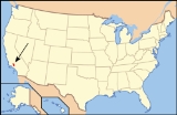
Los Angeles County, California
Los Angeles County is a county in the U.S. state of California. As of 2010 U.S. Census, the county had a population of 9,818,605, making it the most populous county in the United States. Los Angeles County alone is more populous than 42 individual U.S. states...
and Kern counties
Kern County, California
Spreading across the southern end of the California Central Valley, Kern County is the fifth-largest county by population in California. Its economy is heavily linked to agriculture and to petroleum extraction, and there is a strong aviation and space presence. Politically, it has generally...
, California. Opened in 1915 and paved with concrete
Concrete
Concrete is a composite construction material, composed of cement and other cementitious materials such as fly ash and slag cement, aggregate , water and chemical admixtures.The word concrete comes from the Latin word...
between 1917 and 1921, the road was the first paved highway directly linking the Los Angeles Basin
Los Angeles Basin
The Los Angeles Basin is the coastal sediment-filled plain located between the Peninsular and Transverse ranges in southern California in the United States containing the central part of the city of Los Angeles as well as its southern and southeastern suburbs...
with the San Joaquin Valley
San Joaquin Valley
The San Joaquin Valley is the area of the Central Valley of California that lies south of the Sacramento – San Joaquin River Delta in Stockton...
over the Tejon Pass
Tejon Pass
The Tejon Pass is a mountain pass at the southwest end of the Tehachapi Mountains linking Southern to Central California.-Geography:The apex of the pass is near the northwesternmost corner of Los Angeles County, north of Gorman...
and the rugged ridge south of Gorman
Gorman, California
Gorman, California, is an unincorporated community in northwestern Los Angeles County. As of 2005 it had just 15 homes and a few registered voters, but tens of thousands of motorists traveled through it daily on the Interstate 5 freeway....
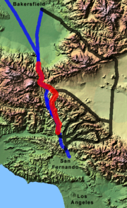
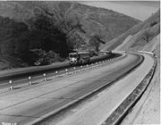
. Most of the road was bypassed in 1933 by the Ridge Route Alternate (then U.S. Route 99), which has since been upgraded to a modern freeway, Interstate 5.
The portion of the road within the Angeles National Forest
Angeles National Forest
The Angeles National Forest of the U.S. National Forest Service is located in the San Gabriel Mountains of Los Angeles County, southern California. It was established on July 1, 1908, incorporating the first San Bernardino National Forest and parts of the former Santa Barbara and San Gabriel...
was added to the National Register of Historic Places
National Register of Historic Places
The National Register of Historic Places is the United States government's official list of districts, sites, buildings, structures, and objects deemed worthy of preservation...
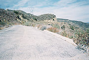
in 1997 and is closed pending repairs; other remnants of the road still remaining are used by local traffic.
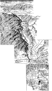
Description
The official limits of the Ridge Route, as built in the 1910s, were State Route 126 at Castaic Junction and the bottom of the grade at GrapevineGrapevine, California
Grapevine is an unincorporated community in Kern County, California. At an elevation of 1499 feet , the community is located at the foot of a road grade known as The Grapevine through the Grapevine Canyon to Tejon Pass in the Tehachapi Mountains at the southern end of the San Joaquin Valley along...
. At that time, the road from San Fernando to Castaic Junction passed through the Newhall Tunnel at San Fernando Pass and ran along San Fernando Road, Magic Mountain Parkway (both part of State Route 126 until the early 2000s), and Feedmill Road to a former bridge over the Santa Clara River
Santa Clara River (California)
The Santa Clara River is approximately long, located in southern California in the United States. It drains an area of the coastal mountains north of Los Angeles. The Santa Clara is one of the largest river systems along the coast of Southern California and one of only a few remaining river...
. A 1930 bypass of the tunnel and Newhall through Weldon Canyon
Weldon Canyon
-Los Angeles County:In Los Angeles County, California, United States, at , Weldon is a canyon through which Interstate 5 passes. The Old Road, now paralleled by I-5, opened on May 28, 1930 through the canyon as a bypass of the 1910 Newhall Tunnel. This original road through the canyon was 20 feet ...
is now part of The Old Road.
From Castaic Junction north to Castaic, the old Ridge Route has been largely buried by construction of the Ridge Route Alternate and Interstate 5. The split of the old Ridge Route and the Alternate at Castaic is now the intersection of Castaic Road and Neely Street, which dead-ends just shy of Ridge Route Road. The first piece of Ridge Route Road out of Castaic has been rebuilt and realigned as recently as the late 1990s, when the North Lake housing development was built. The road begins to climb after passing North Lake; a portion was straightened in 1924, and now lies next to the southbound lanes of I-5. In this area, known as the Five-Mile Grade, the four-lane Ridge Route Alternate was converted into the northbound lanes of I-5, while the added four-lane alignment, built to the east (next to the old Ridge Route), was built with better grades, and became the southbound (downhill) lanes to reduce issues with runaway trucks. Because traffic drives on the right side of the road in the U.S., two bridges had to be built to enable traffic to cross over to the left side. Near the north end of this area, the Ridge Route curves away from the newer bypass.
The road enters the Angeles National Forest
Angeles National Forest
The Angeles National Forest of the U.S. National Forest Service is located in the San Gabriel Mountains of Los Angeles County, southern California. It was established on July 1, 1908, incorporating the first San Bernardino National Forest and parts of the former Santa Barbara and San Gabriel...
about 1 mile (2 km) south of Templin Highway
Templin Highway
Templin Highway is a two-lane road in Los Angeles County, California, United States that connects Interstate 5 and the old Golden State Highway with the north end of Castaic Lake. Originally named Warm Springs Road, it was renamed in 1967 after county highway commissioner Newton H. Templin, who had...
, with the Forest Service road designation 8N04. A number of establishments were located in the forest, including the National Forest Inn, Kelly's Half Way Inn, Tumble Inn, and Sandberg's Summit Hotel.
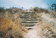
Clapboard (architecture)
Clapboard, also known as bevel siding or lap siding or weather-board , is a board used typically for exterior horizontal siding that has one edge thicker than the other and where the board above laps over the one below...
buildings, it was described in a 1932 highway beautification
Highway beautification
Highway beautification is landscaping and control of the usage of the land by highways.In the United States, highway beautification is subject the Highway Beautification Act, Section 131 of Title 23, United States Code , commonly referred to as "Title I of the Highway Beautification Act of 1965, as...
pamphlet as "the sort of filling station that gets into a national forest and is no addition thereto". On February 14, 1932, a fire began in the garage, and took over a day to put out. Due to the construction of the Ridge Route Alternate, bypassing the site to the west, the inn was not rebuilt, and all that remains are concrete
Concrete
Concrete is a composite construction material, composed of cement and other cementitious materials such as fly ash and slag cement, aggregate , water and chemical admixtures.The word concrete comes from the Latin word...
steps.
Sea level
Mean sea level is a measure of the average height of the ocean's surface ; used as a standard in reckoning land elevation...
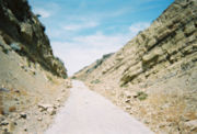
). North of the curves, the road passes through Swede's Cut (34.640°N 118.722°W), also called Big Cut, Culebra Excavation, or Castaic Cut. The cut was the largest on the route, with a depth of 110 feet (34 m).
Reservoir Summit (34.663°N 118.725°W), also called Reservoir Hill, is 3883 feet (1184 m) above sea level. The Reservoir Summit Café was a popular high-class restaurant on the east side of the road, closed in the late 1920s; the foundation
Foundation (architecture)
A foundation is the lowest and supporting layer of a structure. Foundations are generally divided into two categories: shallow foundations and deep foundations.-Shallow foundations:...
remains. The summit was named after a now-dry reservoir
Reservoir
A reservoir , artificial lake or dam is used to store water.Reservoirs may be created in river valleys by the construction of a dam or may be built by excavation in the ground or by conventional construction techniques such as brickwork or cast concrete.The term reservoir may also be used to...
, one of three probably built for the concrete
Concrete
Concrete is a composite construction material, composed of cement and other cementitious materials such as fly ash and slag cement, aggregate , water and chemical admixtures.The word concrete comes from the Latin word...
used in paving the road.
Kelly's Half Way Inn (34.683°N 118.729°W) was roughly halfway between Los Angeles and Bakersfield - 62 and 64 mi (100 and 103 km) respectively. Located on a small knoll with a single tree on the east side of the road, all that remains is remnants of the foundation.

Retaining wall
Retaining walls are built in order to hold back earth which would otherwise move downwards. Their purpose is to stabilize slopes and provide useful areas at different elevations, e.g...
remain.
Timber
Timber may refer to:* Timber, a term common in the United Kingdom and Australia for wood materials * Timber, Oregon, an unincorporated community in the U.S...
s, it was a high-class hotel. The place, which had become a ceramic
Ceramic
A ceramic is an inorganic, nonmetallic solid prepared by the action of heat and subsequent cooling. Ceramic materials may have a crystalline or partly crystalline structure, or may be amorphous...
s factory, burned down on April 29, 1961 from a fire started by the new owner — who was converting it into a "camp-type operation" for underprivileged children—burning trash in the fireplace. The lease from the U.S. Forest Service was canceled in 1963, and only portions of the foundation and a rock wall remain. The name "Sandberg" is still used by the National Weather Service
National Weather Service
The National Weather Service , once known as the Weather Bureau, is one of the six scientific agencies that make up the National Oceanic and Atmospheric Administration of the United States government...
for an automated weather station a short distance to the north at Pine Canyon Road. Pine Canyon Road - County Route N2 - marks the end of the forest and the beginning of county maintenance, and CR N2 uses the old Ridge Route to reach State Route 138 near Quail Lake
Quail Lake
Quail Lake is an artificial lake in Los Angeles County, California. It is located in the San Andreas Rift Zone along the north side of State Route 138, and serves as a regulatory storage body for the West Branch California Aqueduct.If approval By Los Angeles County board after 2010 Quail Lake could...
.
Tejon Pass
The Tejon Pass is a mountain pass at the southwest end of the Tehachapi Mountains linking Southern to Central California.-Geography:The apex of the pass is near the northwesternmost corner of Los Angeles County, north of Gorman...
and past Lebec and Fort Tejon
Fort Tejon
Fort Tejon in California is a former United States Army outpost which was intermittently active from June 24, 1854, until September 11, 1864. It is located in the Grapevine Canyon area of Tejon Pass along Interstate 5, the main route through the mountains separating the Central Valley from Los...
. Past Fort Tejon, the route descends through Grapevine Canyon to Grapevine (named for grape
Grape
A grape is a non-climacteric fruit, specifically a berry, that grows on the perennial and deciduous woody vines of the genus Vitis. Grapes can be eaten raw or they can be used for making jam, juice, jelly, vinegar, wine, grape seed extracts, raisins, molasses and grape seed oil. Grapes are also...
vines in the area). The best-known curve on the road, Deadman's Curve or Death Curve (34.886°N 118.906°W), is visible from Digier Road on the west side of I-5. The next part of old road to still exist is near the bottom of the grade, where a number of curves (34.926°N 118.923°W) brought the road down to Grapevine. The original plan was to build the road nearer to the center of the canyon, but a March 1914 flood destroyed the work, and the grading was redone higher up. Deadman's Curve and the Grapevine loops were both bypassed by the Ridge Route Alternate, which was built directly over most of the old road in this area. At Grapevine, the land suddenly flattens out, and the road north of Grapevine was the longest straight section of road in the state - 17 miles (27 km) - in 1926. Most of this road lies under I-5 and State Route 99, but the southernmost piece in Grapevine was bypassed by the Alternate, and is now in the median of I-5.
Before the Ridge Route
El Camino Real (California)
El Camino Real and sometimes associated with Calle Real usually refers to the 600-mile California Mission Trail, connecting the former Alta California's 21 missions , 4 presidios, and several pueblos, stretching from Mission San Diego de Alcalá in San Diego...
(Spanish, "the King's road"), the first major road in California, connected Los Angeles and the various missions
Spanish missions in California
The Spanish missions in California comprise a series of religious and military outposts established by Spanish Catholics of the Franciscan Order between 1769 and 1823 to spread the Christian faith among the local Native Americans. The missions represented the first major effort by Europeans to...
, presidio
Presidio
A presidio is a fortified base established by the Spanish in North America between the sixteenth and nineteenth centuries. The fortresses were built to protect against pirates, hostile native Americans and enemy colonists. Other presidios were held by Spain in the sixteenth and seventeenth...
s and settlements with San Francisco and Sonoma
Sonoma County, California
Sonoma County, located on the northern coast of the U.S. state of California, is the largest and northernmost of the nine San Francisco Bay Area counties. Its population at the 2010 census was 483,878. Its largest city and county seat is Santa Rosa....
. The San Joaquin Valley route split from the El Camino Real at present-day Universal City, the western leg running along the Pacific Coast
Pacific Coast
A country's Pacific coast is the part of its coast bordering the Pacific Ocean.-The Americas:Countries on the western side of the Americas have a Pacific coast as their western border.* Geography of Canada* Geography of Chile* Geography of Colombia...
and coastal valleys and the eastern El Camino Viejo
El Camino Viejo
El Camino Viejo à Los Angeles , also known as the Old Los Angeles Trail, established in 1820's, was the oldest north-south trail in the interior of Alta California...
, (Spanish, "the old road") laid out via the San Joaquin Valley to San Antonio, now East Oakland.
An alternate route between Los Angeles and Bakersfield followed the southern approach to the Ridge Route to Saugus, but took a longer route between Saugus and Gorman, heading northeast through the San Francisquito Canyon
San Francisquito Canyon
San Francisquito Canyon is a canyon created by the erosion of the Sierra Pelona Ridge of the San Gabriel Mountains within the Transverse Range of California, USA by San Francisquito Creek. At its head is the San Francisquito Pass which the early routes between Los Angeles and the San Joaquin...
to the Antelope Valley
Antelope Valley
The Antelope Valley in California, United States, is located in northern Los Angeles County and the southeastern portion of Kern County, California, and constitutes the western tip of the Mojave Desert...
and west to Gorman. The rest of the route, from Gorman toward Bakersfield via the Tejon Pass
Tejon Pass
The Tejon Pass is a mountain pass at the southwest end of the Tehachapi Mountains linking Southern to Central California.-Geography:The apex of the pass is near the northwesternmost corner of Los Angeles County, north of Gorman...
, followed the same path as the Ridge Route.
The Butterfield Overland Stage
Butterfield Overland Mail
The Butterfield Overland Mail Trail was a stagecoach route in the United States, operating from 1857 to 1861. It was a conduit for the U.S. mail from two eastern termini, Memphis, Tennessee and St. Louis, Missouri, meeting Fort Smith, Arkansas, and continuing through Indian Territory, New Mexico,...
, the first overland mail service to California, went from Tipton
Tipton, Missouri
Tipton is a city in Moniteau County, Missouri, United States. The population was 3,261 at the 2000 census. It is part of the Jefferson City, Missouri Metropolitan Statistical Area.-Geography:Tipton is located at ....
, Missouri
Missouri
Missouri is a US state located in the Midwestern United States, bordered by Iowa, Illinois, Kentucky, Tennessee, Arkansas, Oklahoma, Kansas and Nebraska. With a 2010 population of 5,988,927, Missouri is the 18th most populous state in the nation and the fifth most populous in the Midwest. It...
and Memphis to San Francisco via Los Angeles. From October 1858, when the first stage passed through Tejon Pass, until April 1861, the route was identical to El Camino Viejo, running via San Francisquito Canyon. In order to keep the stages from running directly northwest from San Bernardino and bypassing Los Angeles, the Los Angeles County Board of Supervisors
Los Angeles County Board of Supervisors
The Los Angeles County Board of Supervisors is the five-member nonpartisan governing board of Los Angeles County, California. Members of the board of supervisors are elected by district. They were as of December 2, 2008:*District 1: Gloria Molina...
spent $8000 in 1858 to deepen the cut — later Beale's Cut — at San Fernando Pass, south of Saugus. The path followed by the stages was changed to pass along the Pacific Coast from Los Angeles in April 1861.
Similarly, the residents of the City of Los Angeles approved the expenditure of a good deal of money towards the building of the Southern Pacific Railroad
Southern Pacific Railroad
The Southern Pacific Transportation Company , earlier Southern Pacific Railroad and Southern Pacific Company, and usually simply called the Southern Pacific or Espee, was an American railroad....
, which had originally planned to bypass the city. The line to San Francisco, including the 6966-foot (2123 m) San Fernando Tunnel through San Fernando Pass, was completed on September 5, 1876. The railroad's route between Saugus and Bakersfield was even longer than that of El Camino Viejo and the Butterfield Overland Stage, heading east through Soledad Canyon
Soledad Canyon
Soledad Canyon is a long narrow canyon / valley located in Los Angeles County, California between the cities of Palmdale and Santa Clarita. Soledad Canyon contains the localities of Vincent, Acton, Ravenna, Russ, and Agua Dulce....
before turning north via Palmdale to Mojave and northwest over Tehachapi Pass
Tehachapi Pass
Tehachapi Pass is a mountain pass crossing the Tehachapi Mountains in Kern County, California in the United States. The route over the pass connects the San Joaquin Valley to the Mojave Desert...
.
In the 1910s, several power companies built lines through the area. The General Pipe Line Company completed an oil pipeline connecting the San Joaquin Valley's Midway-Sunset Oil Field
Midway-Sunset Oil Field
The Midway-Sunset Oil Field is a large oil field in Kern County, San Joaquin Valley, California in the United States. Discovered in 1894, and having a cumulative production of close to of oil at the end of 2006, it is the largest oil field in California and the third largest in the United States....
with the port at San Pedro in 1913. Its alignment followed the Ridge Route north of Gorman and south of Reservoir Summit, a longer distance than any of the earlier transportation routes, but from Gorman south to the present location of Pyramid Lake, where it turned east to Reservoir Summit, it roughly followed the later Ridge Route Alternate. That same year, the Midway Gas Company opened a natural gas line, and the Pacific Light and Power Company opened a power line
Electric power transmission
Electric-power transmission is the bulk transfer of electrical energy, from generating power plants to Electrical substations located near demand centers...
, both staying fairly close to the entire Ridge Route.
The two general routes followed by the Butterfield Overland Stage and the Southern Pacific Railroad — known respectively as the Tejon Pass Route and the Tehachapi or Midway Route - were the main automobile
Automobile
An automobile, autocar, motor car or car is a wheeled motor vehicle used for transporting passengers, which also carries its own engine or motor...
routes between Los Angeles and the San Joaquin Valley at the turn of the century. The State Bureau of Highways recommended in 1895 that a more direct route be built to shorten this distance. A bond issue was approved in 1909 and 1910 to build a state highway
State highway
State highway, state road or state route can refer to one of three related concepts, two of them related to a state or provincial government in a country that is divided into states or provinces :#A...
system, including the Ridge Route. The new California Highway Commission
California Highway Commission
The California Highway Commission was established in 1895 and continued until 1978 as the primary state highway bureaucracy in California.Their first noticeable efforts centered on the Lake Tahoe Wagon Road over the Sierra Nevada mountains...
was unable to raise funds in the East
Eastern United States
The Eastern United States, the American East, or simply the East is traditionally defined as the states east of the Mississippi River. The first two tiers of states west of the Mississippi have traditionally been considered part of the West, but can be included in the East today; usually in...
, but Los Angeles again contributed funds to ensure that construction would go forward.
California State Legislature
The California State Legislature is the state legislature of the U.S. state of California. It is a bicameral body consisting of the lower house, the California State Assembly, with 80 members, and the upper house, the California State Senate, with 40 members...
authorized a turnpike
Toll road
A toll road is a privately or publicly built road for which a driver pays a toll for use. Structures for which tolls are charged include toll bridges and toll tunnels. Non-toll roads are financed using other sources of revenue, most typically fuel tax or general tax funds...
in 1861, and it was completed in 1863, then owned by Edward Fitzgerald Beale
Edward Fitzgerald Beale
Edward Fitzgerald "Ned" Beale was a national figure in 19th century America. He was naval officer, military general, explorer, frontiersman, Indian affairs superintendent, California rancher, diplomat, and friend of Kit Carson, Buffalo Bill Cody and Ulysses S. Grant...
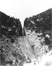
. The cut, which came to be known as Beale's Cut, was deepened by Beale, and lowered once more by the county in 1904. To improve the crossing, the county bypassed the cut with the narrow 435-foot (133 m) Newhall Tunnel, opened in October 1910.
Construction
The California Highway Commission considered several easterly routes between Saugus and Gorman: Soledad CanyonSoledad Canyon
Soledad Canyon is a long narrow canyon / valley located in Los Angeles County, California between the cities of Palmdale and Santa Clarita. Soledad Canyon contains the localities of Vincent, Acton, Ravenna, Russ, and Agua Dulce....
(used by the Southern Pacific) had frequent washout
Washout
A washout is the sudden erosion of soft soil or other support surfaces by a gush of water, usually occurring during a heavy downpour of rain or other stream flooding. These downpours may occur locally in a thunderstorm , or over a large area, such as following the landfall of a tropical cyclone...
s; Mint Canyon (used by the Midway Route) was too long and cost too much; Bouquet Canyon (used by both automobile routes) had bad drainage; and San Francisquito Canyon
San Francisquito Canyon
San Francisquito Canyon is a canyon created by the erosion of the Sierra Pelona Ridge of the San Gabriel Mountains within the Transverse Range of California, USA by San Francisquito Creek. At its head is the San Francisquito Pass which the early routes between Los Angeles and the San Joaquin...
(used by the Tejon Pass Route) was steep and narrow. Another possible route, through Piru Canyon to the west, was rejected because of a proposal for a dam. (This route was later chosen for the Ridge Route Alternate, but had to be abandoned in the 1970s due to the construction of Pyramid Lake.)
Thus the route chosen was a direct line between Saugus and Gorman, over the top of the ridge for many miles. Due to cost and drainage concerns, the road was built with many curves, high in the mountains. Construction on the Ridge Route, officially considered to run from Castaic Junction (west of Saugus on the road to Ventura) to the bottom of the grade at Grapevine, began in 1914.
The new road, designed with an ideal grade of 6% (but with several 7% grades, including at Grapevine), cut the distance by 24 miles (39 km) over the Tejon Pass Route or 58 miles (93 km) over the Midway Route. A speed limit
Speed limit
Road speed limits are used in most countries to regulate the speed of road vehicles. Speed limits may define maximum , minimum or no speed limit and are normally indicated using a traffic sign...
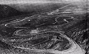
of 15 miles per hour (25 km/h) was enforced between Castaic and Quail Lake, making the trip from Los Angeles to Bakersfield take about 12 hours. On the 48-mile (77 km) Ridge Route, between Castaic Junction and Grapevine, the curves added up to a total of about 109.5 complete circles, with a minimum radius
Radius of curvature (mathematics)
In geometry, the radius of curvature, R, of a curve at a point is a measure of the radius of the circular arc which best approximates the curve at that point. If this value taken to be positive when the curve turns anticlockwise and negative when the curve turns clockwise...
of 70 feet (21 m). The unpaved road, which had cost $450,000, opened in October 1915.
In addition to being part of the state highway system (as a portion of the unsigned Sacramento-Los Angeles Legislative Route 4), the road was also part of the National Park to Park Highway
National Park to Park Highway
The National Park to Park Highway was an auto trail in the United States in the 1910s and 1920s, plotted by A. L. Westgard. It followed a large loop through the West, connecting twelve National Parks:*Rocky Mountain National Park*Yellowstone National Park...
, a privately-designated auto trail
Auto trail
The system of auto trails was an informal network of marked routes that existed in the United States and Canada in the early part of the 20th century. Marked with colored bands on telephone poles, the trails were intended to help travellers in the early days of the automobile.Auto trails were...
, and became part of U.S. Route 99 in 1926. The continuation south via Saugus and the Newhall Tunnel towards Los Angeles, also part of Route 4, was added to the state highway system in 1917.
According to the San Francisco Chronicle
San Francisco Chronicle
thumb|right|upright|The Chronicle Building following the [[1906 San Francisco earthquake|1906 earthquake]] and fireThe San Francisco Chronicle is a newspaper serving primarily the San Francisco Bay Area of the U.S. state of California, but distributed throughout Northern and Central California,...
, the new route was "one of the most remarkable engineering feats accomplished by the State Highway Commission. It is Southern California's Magnus Opus
Masterpiece
Masterpiece in modern usage refers to a creation that has been given much critical praise, especially one that is considered the greatest work of a person's career or to a work of outstanding creativity, skill or workmanship....
[sic
Sic
Sic—generally inside square brackets, [sic], and occasionally parentheses, —when added just after a quote or reprinted text, indicates the passage appears exactly as in the original source...
] in mountain highway construction." It was also credited with stopping efforts to split California into two states, by linking its two halves over the rugged terrain separating them.
Pavement (material)
Road surface or pavement is the durable surface material laid down on an area intended to sustain vehicular or foot traffic, such as a road or walkway. In the past cobblestones and granite setts were extensively used, but these surfaces have mostly been replaced by asphalt or concrete. Such...
the Ridge Route with 20-foot (6 m) wide and 4-inch (100 mm) thick reinforced concrete
Reinforced concrete
Reinforced concrete is concrete in which reinforcement bars , reinforcement grids, plates or fibers have been incorporated to strengthen the concrete in tension. It was invented by French gardener Joseph Monier in 1849 and patented in 1867. The term Ferro Concrete refers only to concrete that is...
began in 1917, but was delayed until 1919 by the U.S. entry into World War I
World War I
World War I , which was predominantly called the World War or the Great War from its occurrence until 1939, and the First World War or World War I thereafter, was a major war centred in Europe that began on 28 July 1914 and lasted until 11 November 1918...
. During work on the central portion, traffic was detour
Detour (road)
A detour or diversion route is a route around a planned area of prohibited or reduced access, such as a construction site.Standard operating procedure for many road departments is to route any detour over roads within the same jurisdiction as the road with the obstructed area.On multi-lane highways...
ed via Mint and Bouquet Canyons. The road was reopened on November 15, 1919, completely paved except north of Lebec, including the grade at Grapevine, which was only oiled. After a bond issue was passed in July 1919, this portion was paved from September 1919 to May 1921; the dangerous detour included a 20% grade. This paving added about $1 million to the cost, for a total price of about $1.5 million, not paid off until 1965. Asphalt
Asphalt
Asphalt or , also known as bitumen, is a sticky, black and highly viscous liquid or semi-solid that is present in most crude petroleums and in some natural deposits, it is a substance classed as a pitch...
was added on top of the concrete for 20 miles (32 km) south from Swede's Cut in 1922, and in 1924 a number of dangerous blind curves were widened and straightened.
Bypasses and the fate of the bypassed road
Radius of curvature (mathematics)
In geometry, the radius of curvature, R, of a curve at a point is a measure of the radius of the circular arc which best approximates the curve at that point. If this value taken to be positive when the curve turns anticlockwise and negative when the curve turns clockwise...
from 70 feet (21 m) to 1000 feet (300 m). Construction began in 1930, and the road south of Tejon Pass was officially opened on October 29, 1933; replacement of the Grapevine grade was completed by 1936. The road, which included a center "suicide" passing lane, cost $3.5 million, paid for by the state gas tax. It was estimated that it would pay itself off in 2.5 years with the savings in time and gas. A new bypass of the Newhall Tunnel, through Weldon Canyon
Weldon Canyon
-Los Angeles County:In Los Angeles County, California, United States, at , Weldon is a canyon through which Interstate 5 passes. The Old Road, now paralleled by I-5, opened on May 28, 1930 through the canyon as a bypass of the 1910 Newhall Tunnel. This original road through the canyon was 20 feet ...
, had been opened on May 28, 1930, thus giving drivers a better route all the way from Los Angeles to Bakersfield. The roadway was widened to an expressway
Limited-access road
A limited-access road known by various terms worldwide, including limited-access highway, dual-carriageway and expressway, is a highway or arterial road for high-speed traffic which has many or most characteristics of a controlled-access highway , including limited or no access to adjacent...
by 1952 at a cost of $13.5 million, providing two lanes in each direction and a center median, but retaining at-grade intersection
At-grade intersection
An at-grade intersection is a junction at which two or more transport axes cross at the same level .-Traffic management:With areas of high or fast traffic, an at-grade intersection normally requires a traffic control device such as a stop sign, traffic light or railway signal to manage conflicting...
s. The 1955 song Hot Rod Lincoln
Hot Rod Lincoln
"Hot Rod Lincoln" was recorded in 1955, as an answer song to "Hot Rod Race", a 1951 hit for Arkie Shibley and his Mountain Dew Boys. Hot Rod Race tells the story of a late-model Ford and Mercury who end up racing along the highway, neither driver gaining an advantage, and staying "neck and neck"...
celebrates the long steep and already fairly straight section up Grapevine Canyon.
Even this four-lane Ridge Route Alternate was not good enough for the large amounts of traffic using the road, and construction of the eight-lane freeway Interstate 5 with a minimum curve radius of 3000 feet (900 m) began in June 1963. Large parts of the Ridge Route Alternate were incorporated into the new roadway, but the area through the present Pyramid Lake was completely bypassed. Interstate 5 over the mountains between Castaic Junction and Grapevine, still in use today, was completed on August 24, 1970 at a cost of $103 million.
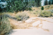
Meanwhile, the old road continued to exist in several pieces as a local county road. The longest preserved segment was that part completely bypassed by the Ridge Route Alternate, between Castaic and State Route 138 near Sandberg
Sandberg, California
Sandberg is the name of a post office and small surrounding community that was attached to Sandberg's lodge or inn on Southern California's Ridge Route highway, which linked the Los Angeles area to Central California from 1919 through 1933....
, including the portion through the Angeles National Forest
Angeles National Forest
The Angeles National Forest of the U.S. National Forest Service is located in the San Gabriel Mountains of Los Angeles County, southern California. It was established on July 1, 1908, incorporating the first San Bernardino National Forest and parts of the former Santa Barbara and San Gabriel...
. The road for about 2 miles (3 km) south from SR 138 is part of County Route N2, but the rest only serves local travel.
Harrison Scott was traveling north on Interstate 5 with his son in 1991, when his son speculated about the difficulty of driving over the first road through the rugged terrain. Having some extra time, and recalling a drive on the old road in 1955, they left the freeway and traveled along most of the abandoned section. Near SR 138, Scott asked a county road crew which was resurfacing the road if it was still maintained by the county, and the crew replied that they didn't know who maintained it through the desert. It turned out that the county officially owned it but did not maintain it; Scott has since convinced the county and forest to exchange ownership with the Santa Anita Canyon Road, then a county road.
For the next six years, Scott worked on getting the road added to the National Register of Historic Places
National Register of Historic Places
The National Register of Historic Places is the United States government's official list of districts, sites, buildings, structures, and objects deemed worthy of preservation...
, and finally succeeded when, on September 25, 1997, the National Park Service
National Park Service
The National Park Service is the U.S. federal agency that manages all national parks, many national monuments, and other conservation and historical properties with various title designations...
added the 17.6 miles (28.3 km) within the forest to the National Register. He subsequently wrote a book, Ridge Route: The Road That United California, from the research he had done for the National Register application.
External links
- Ridge Route Preservation Organization
- Historic US 99 Guide: The Ridge Route (includes detailed history of the Ridge Route Alternate and Interstate 5)
- Virtual Tour of the Ridge Route (includes detailed history of the Ridge Route Alternate and Interstate 5)
- The Mountain Enterprise (local newspaper) (mostly old postcards)